1 of 10
A Set of Four Miguel Covarrubias Pacific Maps
$5,600List Price
About the Item
- Dimensions:Height: 36.5 in (92.71 cm)Width: 39 in (99.06 cm)Depth: 1.25 in (3.18 cm)
- Materials and Techniques:
- Place of Origin:
- Period:
- Date of Manufacture:1940
- Condition:Excellent.
- Seller Location:Hudson, NY
- Reference Number:1stDibs: 1207198307580
Authenticity Guarantee
In the unlikely event there’s an issue with an item’s authenticity, contact us within 1 year for a full refund. DetailsMoney-Back Guarantee
If your item is not as described, is damaged in transit, or does not arrive, contact us within 7 days for a full refund. Details24-Hour Cancellation
You have a 24-hour grace period in which to reconsider your purchase, with no questions asked.Vetted Professional Sellers
Our world-class sellers must adhere to strict standards for service and quality, maintaining the integrity of our listings.Price-Match Guarantee
If you find that a seller listed the same item for a lower price elsewhere, we’ll match it.Trusted Global Delivery
Our best-in-class carrier network provides specialized shipping options worldwide, including custom delivery.You May Also Like
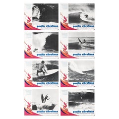
Pacific Vibrations
Located in London, GB
Original US set of 8 Lobby cards for the 1970 surfing documentary by John Severson features some good interviews, great music and surfing footage….like Woodstock on a wave. This se...
Category
Vintage 1970s American Posters
Materials
Paper
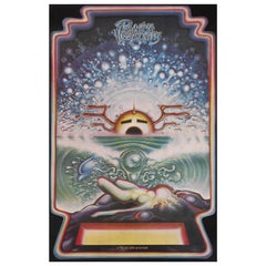
Pacific Vibrations
Located in London, GB
Exceptionally rare US film poster, that was only used for the film's American premiere in 1970.
This surfing documentary by John Severson's features som...
Category
Vintage 1970s American Posters
Materials
Paper
Set of (14) Vintage Anatomy Charts by American Map Co. - sold individually
Located in Philadelphia, PA
Set of (14) Vintage Anatomy Charts
American Map Co. - Circa 1950.
14 Total Charts - Sold Individually -( 14 available )
( discounted to buy as a set )
29" x 37" unfolded
9.5" x 12...
Category
Mid-20th Century American Mid-Century Modern Posters
Materials
Paper
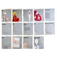
$100 / item
H 37 in W 29 in D 0.07 in
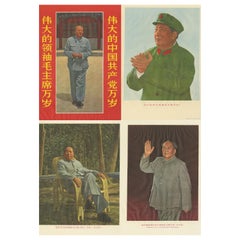
Set of Four Vintage Mao Zedong Posters, circa 1968
Located in Langweer, NL
A set of propaganda photographic posters featuring well-known images of Chairman Mao. Mao Zedong, also known as Chairman Mao, was a Chinese communist...
Category
Late 20th Century Prints
Materials
Paper
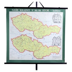
Vintage School Map of Czechoslovakia, 1960s
Located in Zohor, SK
This is a great vintage school map produced in Czechoslovakia by Skolske pomucky n.p., which was a national factory for producing the school items i...
Category
Vintage 1960s Slovak Mid-Century Modern Posters
Materials
Paper
Original WWII Illustrated Map Poster - Time And Tide Map Of The Atlantic Charter
By "Leslie MacDonald ""Max"" Gill"
Located in London, GB
Original vintage illustrated map poster in Spanish by the notable graphic designer, cartographer and artist MacDonald Gill (Leslie MacDonald Gill aka Max Gill; 1884-1947) commissioned by the British Time & Tide magazine (1920-1986) following the World War Two Atlantic Charter agreement between the US President Franklin D. Roosevelt and UK Prime Minister Winston Churchill "for a better future for the world" 14 August 1941 - La Carta del Atlantico. Stunning design featuring detailed colorful pictorial depictions of agriculture and food production, Industrial raw materials and traditional life around the world including images of people, animals, trees, cattle, ships at sea, planes flying overhead and markers with a symbol box listing the locations of metals, wine, crops, petroleum, tobacco, sugar, rubber, silk, coffee, fruit, precious stones etc., surrounded by clouds on the sides and the sun shining down from The Atlantic Charter in the text box at the top with a black and white image below of an Industrial metal worker destroying tanks and machinery and a farming family ploughing a field with horses, the cities, countries, continents and quotes in banners with a seal and a compass point on both sides, all framed within a decorative border. Printed in Great Britain by Philip George & Son Ltd London and published in collaboration with the Time and Tide...
Category
Vintage 1940s British Posters
Materials
Paper
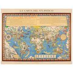
$7,509
H 44.89 in W 34.85 in D 0.04 in
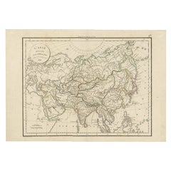
Antique Map of Asia by Delamarche, 1826
Located in Langweer, NL
Vaugondy's map plates and copyrights and later addes many plates from other sources as well. Charles Delamarche eventually passed control of the firm to his son Felix Delamarche (18t...
Category
Antique 19th Century Maps
Materials
Paper
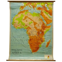
W&A K Johnston’s Charts of Physical Maps by G W Bacon
Located in Godshill, Isle of Wight
Large University chart “Africa Physical Political” by Bacon
W&A K Johnston’s charts of physical maps by G W Bacon,
This is a Physical Political map...
Category
Early 20th Century Rustic Posters
Materials
Linen
Large Detailed Map of Australia Wint Inset of Tasmania, 1937
Located in Langweer, NL
Antique map titled 'Australia'. Large folding map of Australia. With inset map of Tasmania. Printed by L.F. Johnston, Canberra.
Artists and Engravers: Compiled and drawn by Propert...
Category
20th Century Maps
Materials
Paper

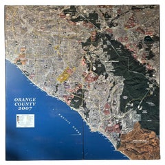
Large Format Map of Orange County, CA 2007
Located in Alhambra, CA
Killer Large Format Map of Orange County CA.
Two panels 90” h x 45” wide. Amazing detail.
Good vintage condition.
2007 Landiscor.
Category
21st Century and Contemporary American Post-Modern Posters
Materials
Paper
Still Thinking About These?
All Recently ViewedMore Ways To Browse
Villemot Perrier Poster
Vintage Basketball Posters
Vintage German Anatomical Chart
Vintage Hygiene Posters
Vintage Ice Hockey Posters
Vintage Indonesian Posters
Vintage Isle Of Wight Posters
Vintage Japanese Godzilla Poster
Vintage Lora Lamm
Vintage Peugeot Poster
Vintage Poster Indonesia
Vintage Poster Turkey
Vintage Posters Soap
Vintage Posters Ww1
Vintage Pull Down Anatomy Chart
Vintage Shakespeare Posters
Vintage Snoopy Poster
Vintage Tennis Posters Davis Cup