Items Similar to Antique Map of Batavia by Van Schley
c.1750


Want more images or videos?
Request additional images or videos from the seller
1 of 5
Antique Map of Batavia by Van Schley
c.1750
$431.22
$539.0320% Off
£322.46
£403.0720% Off
€360
€45020% Off
CA$594.12
CA$742.6420% Off
A$647.97
A$809.9620% Off
CHF 343.25
CHF 429.0620% Off
MX$7,768.19
MX$9,710.2420% Off
NOK 4,371.46
NOK 5,464.3320% Off
SEK 3,997.38
SEK 4,996.7220% Off
DKK 2,743.34
DKK 3,429.1820% Off
About the Item
Antique map titled 'Batavia'. Original antique map of Batavia, Jakarta, Indonesia. This print originates from the Dutch edition of Prevost's 'Histoire Generale des Voyages' (Paris 1746-1759). Engraved by J. van Schley.
- Dimensions:Height: 9.85 in (25 cm)Width: 19.69 in (50 cm)Depth: 0.02 in (0.5 mm)
- Materials and Techniques:
- Period:
- Date of Manufacture:circa 1750
- Condition:General age-related toning. Original folding lines. Minor wear, blank verso. Please study image carefully.
- Seller Location:Langweer, NL
- Reference Number:Seller: BG-12950-111stDibs: LU3054325444452
About the Seller
5.0
Recognized Seller
These prestigious sellers are industry leaders and represent the highest echelon for item quality and design.
Platinum Seller
Premium sellers with a 4.7+ rating and 24-hour response times
Established in 2009
1stDibs seller since 2017
2,788 sales on 1stDibs
Typical response time: <1 hour
- ShippingRetrieving quote...Shipping from: Langweer, Netherlands
- Return Policy
More From This Seller
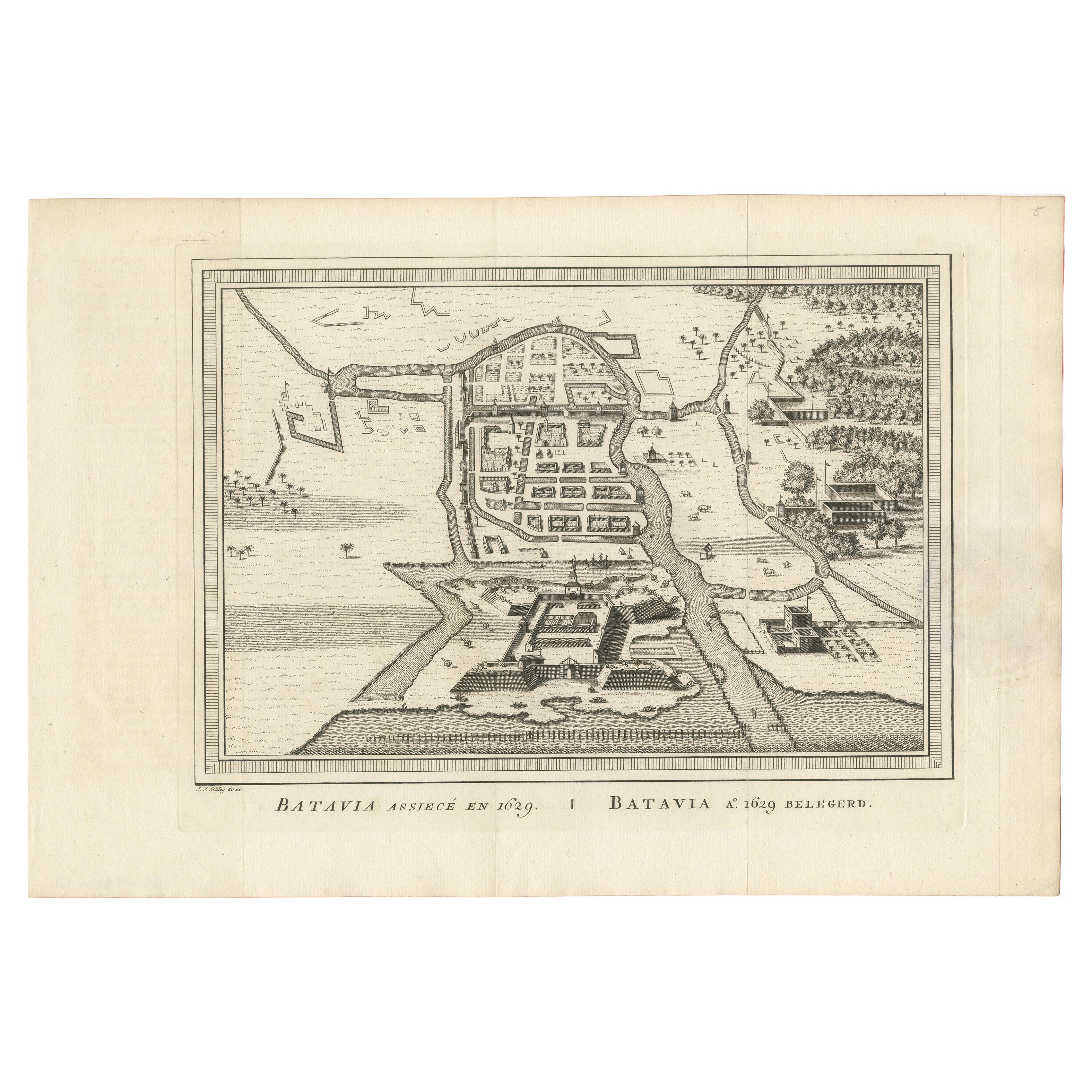
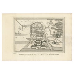
View AllAntique Map of the Siege of Batavia by Van Schley
c.1750
Located in Langweer, NL
Antique map titled 'Batavia assiecé en 1629 - Batavia 1629 belegerd'. Bird's eye view map of the siege of Batavia in 1629, Jakarta, Indonesia. This print originates from the Dutch ed...
Category
Antique Mid-18th Century Prints
Materials
Paper
$239 Sale Price
20% Off
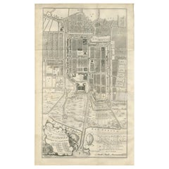
Antique Map of Batavia
Jakarta, Indonesia
, the Dutch East-Indies, 1782
Located in Langweer, NL
Antique map titled 'Batavia zo als het was in den Jaare 1731.' (Batavia as it was in the year 1731.) Map of the city of Batavia (Jakarta) in Indonesia. With legend and scale. This pr...
Category
Antique 18th Century Maps
Materials
Paper

Antique Map of the City of Batavia by Van der Aa, circa 1730
Located in Langweer, NL
Antique map titled 'Plan de la Ville et du Chateau de Batavia en l'Isle de Iava - Ware affbeeldinge wegens het Casteel ende Stadt Batavia gelegen op groot Eylant Java'. Detailed plan...
Category
Antique Mid-18th Century Dutch Maps
Materials
Paper

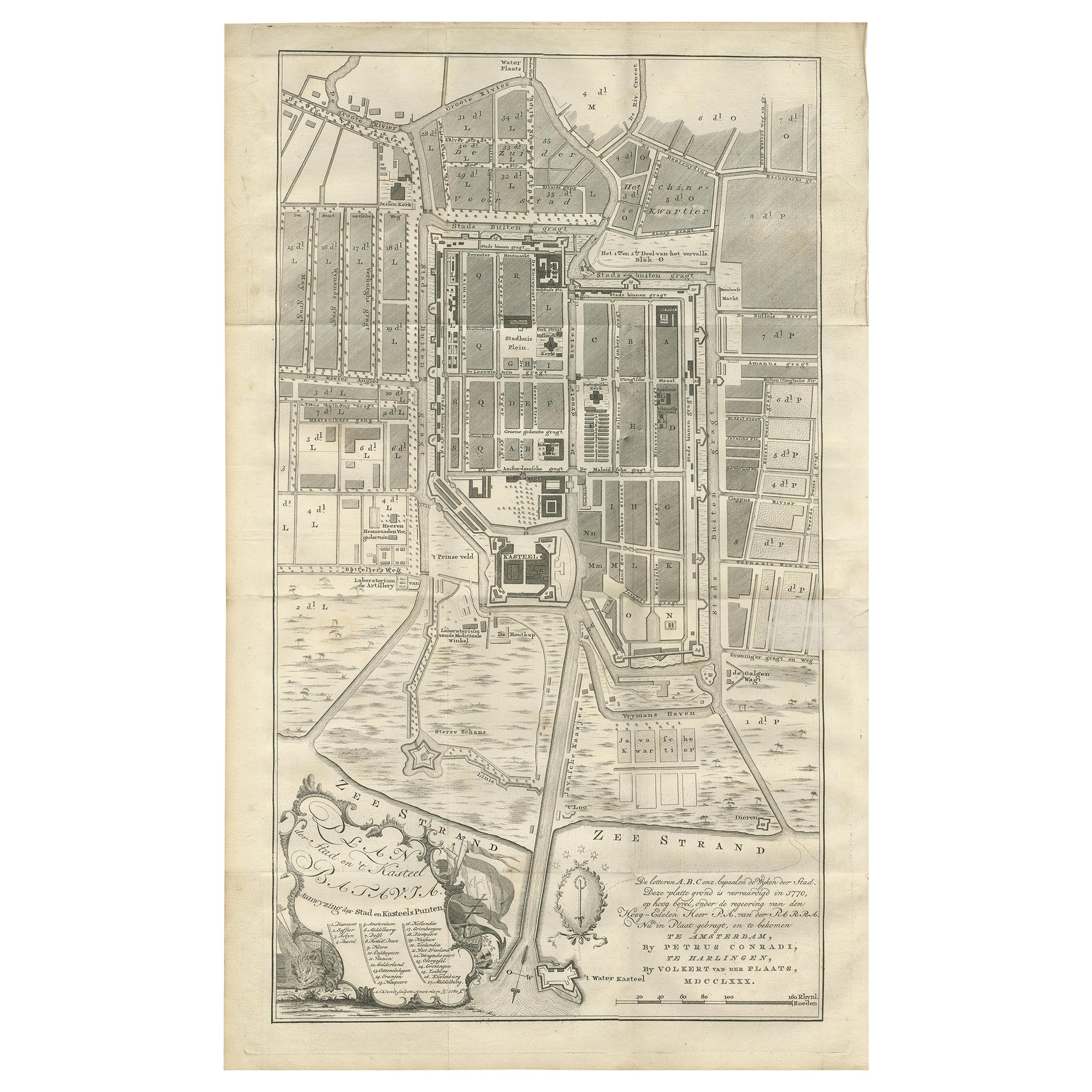
Antique Plan of Batavia by Van Krevelt, circa 1780
Located in Langweer, NL
Antique map titled 'Plan der Stad en 't Kasteel Batavia'. A very rare late 18th century detailed plan of Batavia, Indonesia, with an alpha-numeric key showing the main areas and buil...
Category
Antique Late 18th Century Dutch Prints
Materials
Paper
$1,796 Sale Price
40% Off
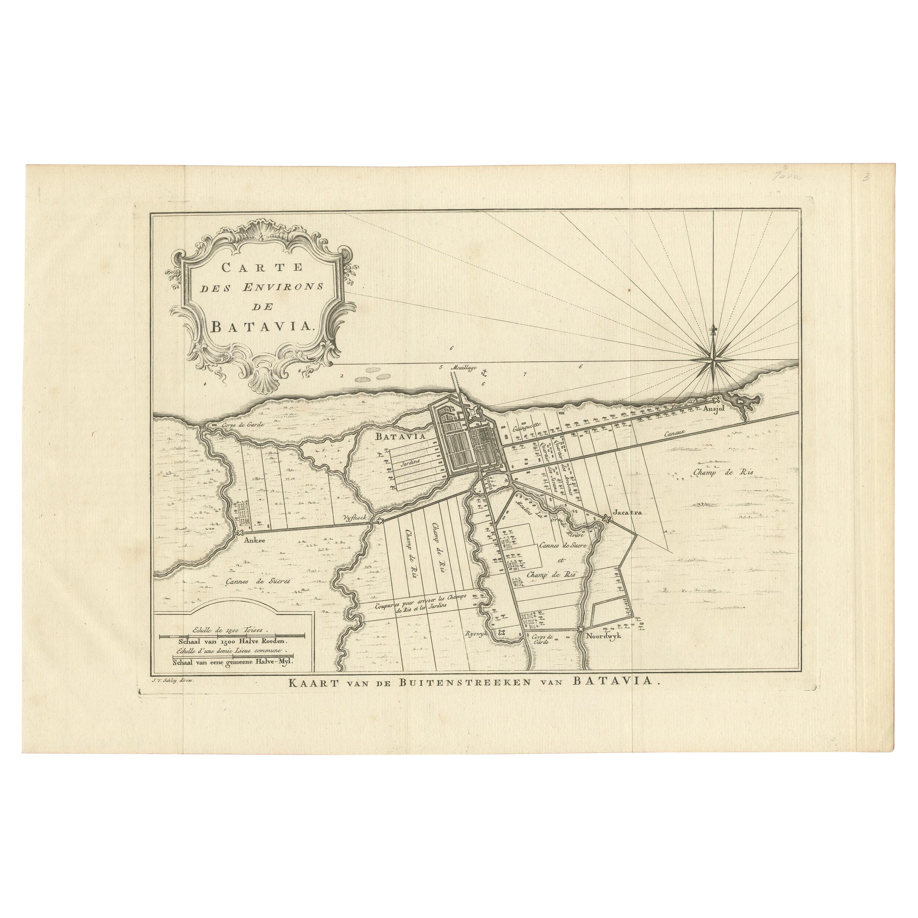
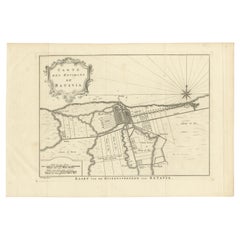
Antique Print of the Region of Batavia by Van Schley
c.1750
Located in Langweer, NL
Antique print titled 'Carte des Environs de Batavia - Kaart van de Buitenstreeken van Batavia'. Map of Batavia and surroundings (Jakarta). This print originates from the Dutch editio...
Category
Antique Mid-18th Century Prints
Materials
Paper
$287 Sale Price
20% Off
Antique Map of Batavia, Jakarta, Indonesia by P. Van Der Aa, 1719
Located in Langweer, NL
A small early 18th century black and white map of Batavia by the Dutch cartographer Pieter Van Der Aa. This map was first published in his 'Nouvel ...
Category
Antique Early 18th Century Prints
Materials
Paper

You May Also Like
1748 Map of Richmond Upon Thames by John Roque
Located in Gloucestershire, GB
A 1748 map of Richmond-Upon-Thames by famed surveyor and cartographer, John Roque. Placed in a simple black and gilt frame. The map is in fair condition but there are small sections ...
Category
Antique Mid-18th Century English Maps
Materials
Wood, Paper

Map Of The City Of Geneva, Framed Engraving, Late 18th Century
Located in MARSEILLE, FR
Beautiful engraving representing the city of Geneva corrected in 1775 and 1793
The engraving also presents inserts with the evolution of the city, the plan of ancient Geneva and ...
Category
Antique Late 18th Century Swiss Louis XV Prints
Materials
Paper

Antique Town Plan Map, Poole, English, Framed Cartography, Georgian, Circa 1780
Located in Hele, Devon, GB
This is an antique town plan map of Poole in Dorset. An English, framed atlas engraving, dating to the 18th century and later.
Fascinating cartography with annotated streets and pl...
Category
Antique Late 18th Century British George III Maps
Materials
Glass, Wood, Paper

1597 German Map of Alexandria by Georg Braun and Frans Hogenberg
By Georg Braun and Frans Hogenberg
Located in Chapel Hill, NC
1597 Map of Alexandria by Georg Braun and Frans Hogenberg, Germany. From "Civitas Orbis Terrarum", part 2, published in Cologne by Bertram Buchholz. Printed in 2 parts. Title: "Alexa...
Category
Antique 16th Century German Renaissance Maps
Materials
Paper

$480 Sale Price
20% Off
Large Original Antique Folding Map of Manchester, England, Dated 1793
Located in St Annes, Lancashire
Superb map of Manchester and Salford
Folding map. Printed on paper laid on to the original canvas
Unframed.
Published by C. Laurent, 1793.
Free shippi...
Category
Antique 1790s English Georgian Maps
Materials
Canvas, Paper

1752 Vaugoundy Map of Flanders : Belgium, France, and the Netherlands, Ric.a002
Located in Norton, MA
Large Vaugoundy Map of Flanders:
Belgium, France, and the Netherlands
Colored -1752
Ric.a002
Description: This is a 1752 Didier Robert de Vaugondy map of Flanders. The map de...
Category
Antique 17th Century Unknown Maps
Materials
Paper
