Items Similar to Antique Map of Kerguelens Island Coast by Cook, 1784


Want more images or videos?
Request additional images or videos from the seller
1 of 6
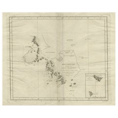
Antique Map of Kerguelens Island Coast by Cook, 1784
$324.27
$432.3625% Off
£240.20
£320.2725% Off
€270
€36025% Off
CA$443.68
CA$591.5825% Off
A$482.76
A$643.6825% Off
CHF 255.62
CHF 340.8225% Off
MX$5,807.93
MX$7,743.9125% Off
NOK 3,245.75
NOK 4,327.6625% Off
SEK 2,969.63
SEK 3,959.5125% Off
DKK 2,057.62
DKK 2,743.4925% Off
About the Item
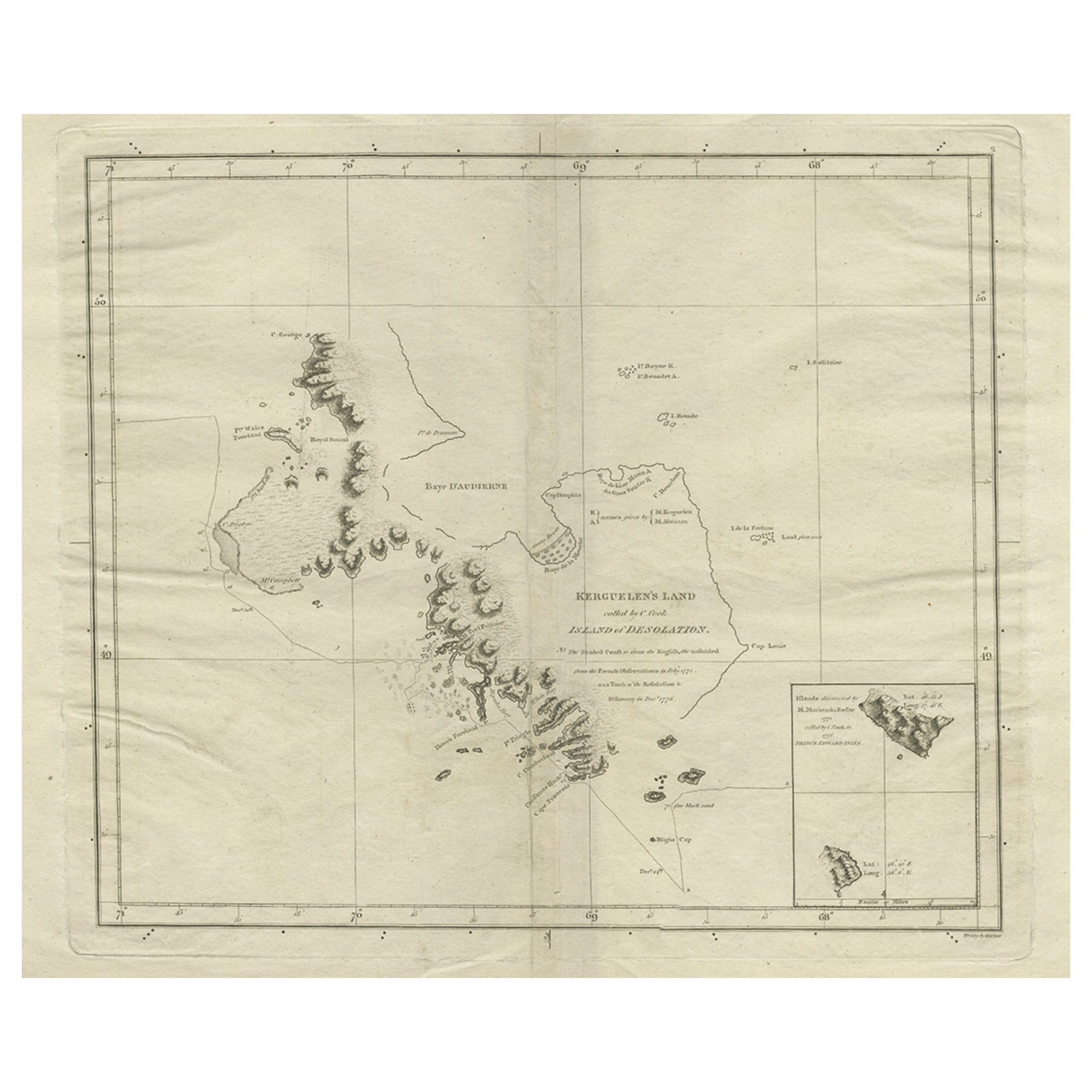
Antique print titled 'Kerguelen's Land (..)'. Antique map of Kerguelens island coast, known today as the Desolation islands. Originates from 'A Voyage to the Pacific Ocean: Undertaken, by the Command of His Majesty, for Making Discoveries in the Northern Hemisphere (..)' published in Dublin.
Artists and Engravers: James Cook (Author, 1728-1779) was a British captain, explorer and cartographer.
Condition: Good, general age-related toning. Some defects, also along folding lines. Please study image carefully.
Date: 1784
Overall size: 40 x 29 cm.
Image size: 29 x 35 cm.
Antique prints have long been appreciated for both their aesthetic and investment value. They were the product of engraved, etched or lithographed plates. These plates were handmade out of wood or metal, which required an incredible level of skill, patience and craftsmanship. Whether you have a house with Victorian furniture or more contemporary decor an old engraving can enhance your living space. We offer a wide range of authentic antique prints for any budget.
- Creator:James Cook (Author)
- Dimensions:Height: 11.42 in (29 cm)Width: 15.75 in (40 cm)Depth: 0 in (0.01 mm)
- Materials and Techniques:
- Period:
- Date of Manufacture:1784
- Condition:Condition: Good, general age-related toning. Some defects, also along folding lines. Please study image carefully.
- Seller Location:Langweer, NL
- Reference Number:Seller: BGJC-2111stDibs: LU3054329869792
About the Seller
5.0
Recognized Seller
These prestigious sellers are industry leaders and represent the highest echelon for item quality and design.
Platinum Seller
Premium sellers with a 4.7+ rating and 24-hour response times
Established in 2009
1stDibs seller since 2017
2,816 sales on 1stDibs
Typical response time: 1 hour
- ShippingRetrieving quote...Shipping from: Langweer, Netherlands
- Return Policy
More From This Seller
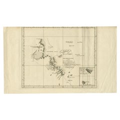
View AllAntique Map of Kerguelens Island Coast in the Indian Ocean by Cook, 1785
By James Cook
Located in Langweer, NL
Antique print titled 'Kerguelen's Land (..)'. Antique map of Kerguelens island coast, known today as the Desolation islands. Originates from 'Voyage to the Pacific Ocean, undertaken ...
Category
Antique 18th Century Prints
Materials
Paper
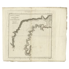
Antique Map of the Coast of Kerguelens Island by Cook, 1803
Located in Langweer, NL
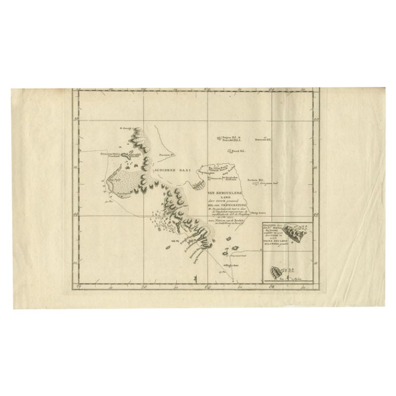
Antique map Desolation Islands titled 'Van Kerguelens Land door Cook genaamd (..)'. Antique map of Kerguelens island coast, known today as the Desolation islands. Originates from 'Re...
Category
Antique 19th Century Maps
Materials
Paper
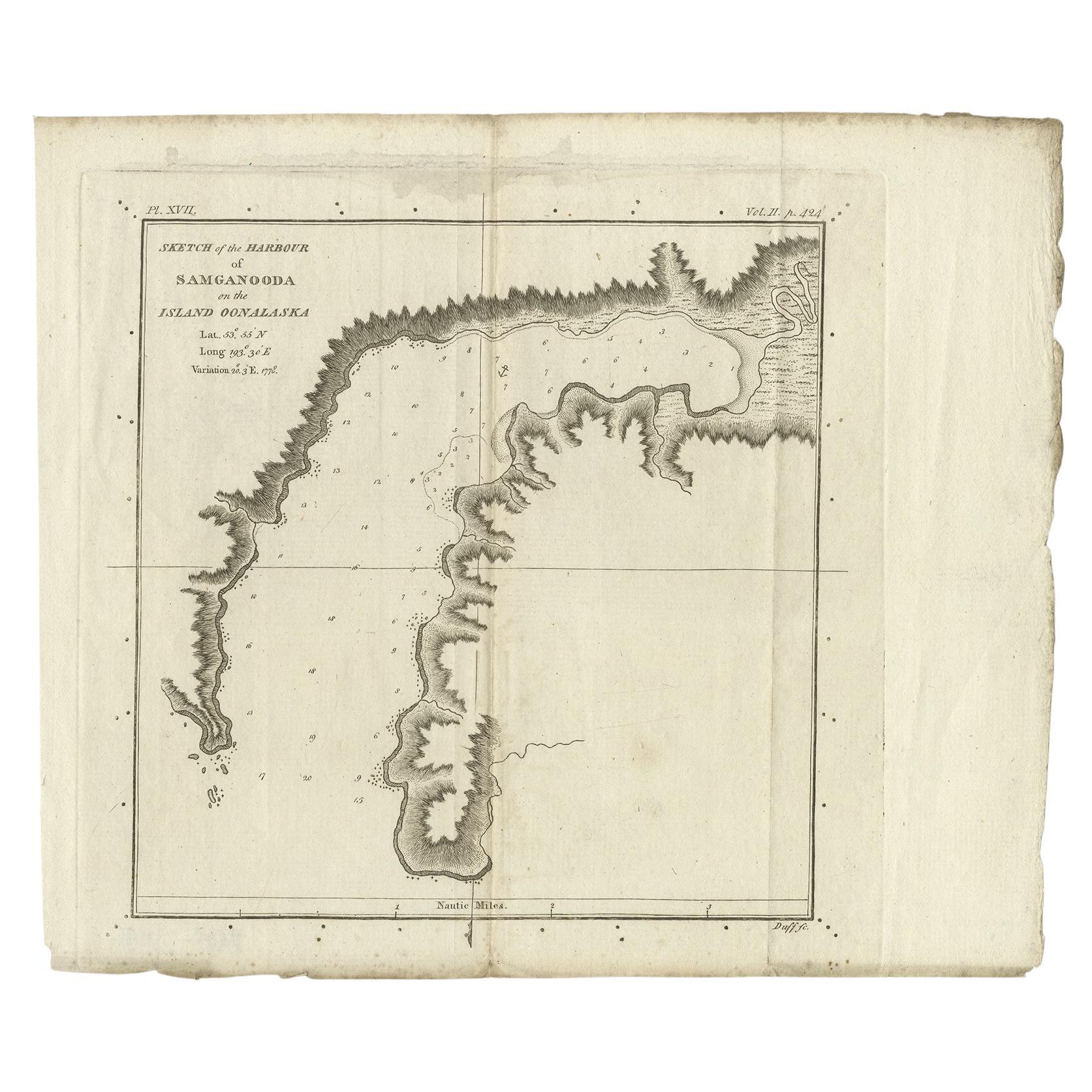
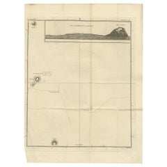
Antique Map of the Harbour of Samganoodha by Cook, c.1781
Located in Langweer, NL
Antique map titled 'Sketch of the Harbour of Samganooda (..)'. Antique map of the Harbour of Samganoodha, Oonalaska, North America. Originates from an edition of Cook's Voyages.
Art...
Category
Antique 18th Century Maps
Materials
Paper
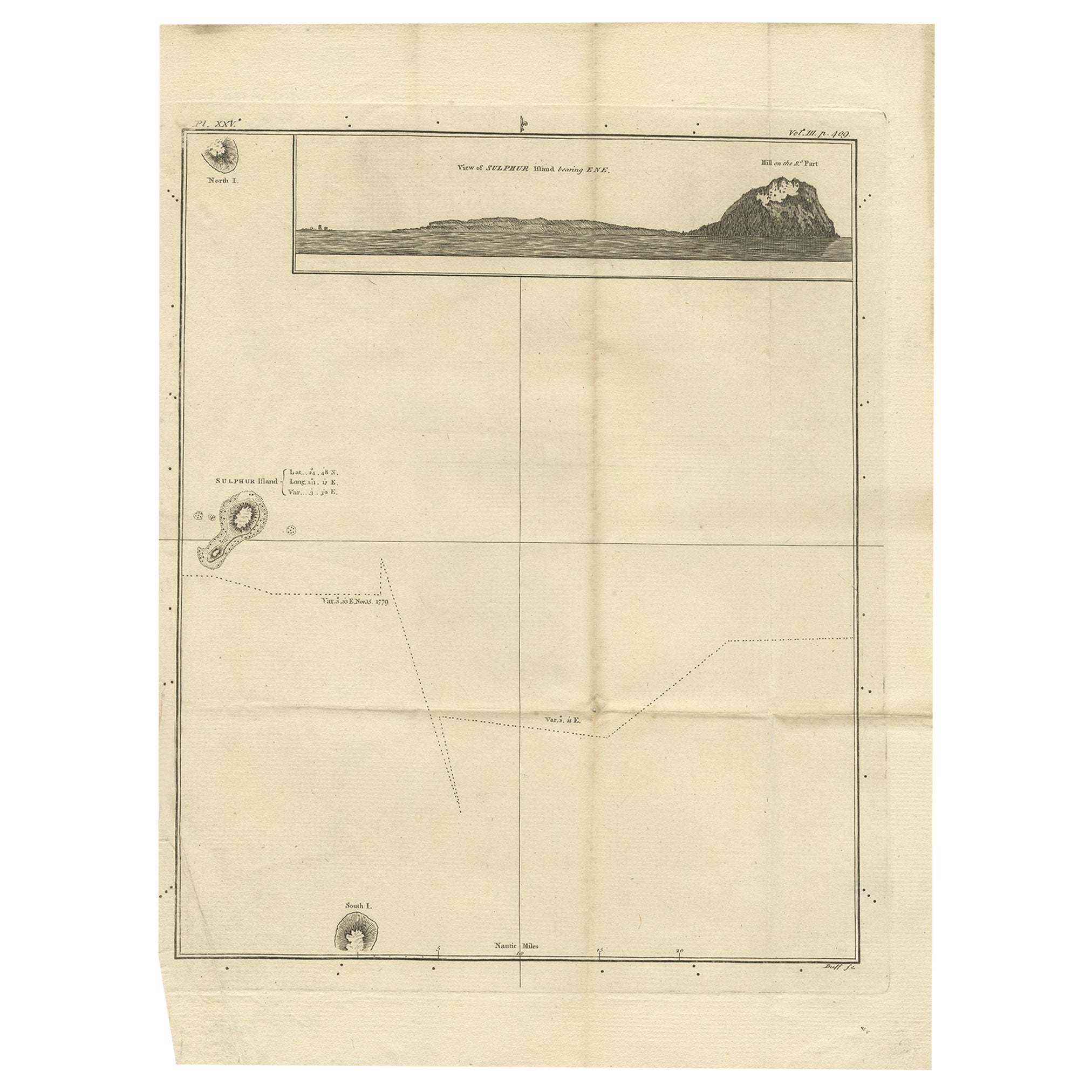
Antique Map of Suffren Island by Cook, c.1781
Located in Langweer, NL
Antique map titled 'View of Sulphur Island (..)'. Antique map and view of Suffren Island. Originates from an edition of Cook's Voyages.
Artists and Engravers: Engraved by Duff.
...
Category
Antique 18th Century Maps
Materials
Paper
$144 Sale Price
20% Off
Antique Map of the Friendly Islands by Cook, 1803
Located in Langweer, NL
Antique map Friendly Islands titled 'Kaart van de Vrienden Eilanden'. Antique map of the Friendly Islands depicting Rotterdam or Anamocka, Middelburg or Eaoowe and Amsterdam or Tonga...
Category
Antique 19th Century Maps
Materials
Paper

Antique Map of the Friendly Islands by Cook, 1803
Located in Langweer, NL
Antique map Friendly Islands titled 'Kaart van de Vrienden-Eilanden'. Antique map of the Friendly Islands depicting Rotterdam or Anamocka, Middelburg or Eaoowe and Amsterdam or Tonga...
Category
Antique 19th Century Maps
Materials
Paper

You May Also Like
Von Reilly Map of the Russian Empire, 1796
Located in Savannah, GA
A map of the Russian Empire in Europe by Von Reilly. Published in Vienna, 1796.
32 inches wide by 24 ½ inches tall
Category
Antique 1790s Austrian Prints
Materials
Glass, Wood, Paper

Original Antique Map of South America. C.1780
Located in St Annes, Lancashire
Great map of South America
Copper-plate engraving
Published C.1780
Two small worm holes to left side of map
Unframed.
Category
Antique Early 1800s English Georgian Maps
Materials
Paper

California, Alaska and Mexico: 18th Century Hand-Colored Map by de Vaugondy
By Didier Robert de Vaugondy
Located in Alamo, CA
This is an 18th century hand-colored map of the western portions of North America entitled "Carte de la Californie et des Pays Nord-Ouest separés de l'Asie par le détroit d'Anian, ex...
Category
Antique 1770s French Maps
Materials
Paper

West Coast of Africa, Guinea
Sierra Leone: An 18th Century Map by Bellin
By Jacques-Nicolas Bellin
Located in Alamo, CA
Jacques Bellin's copper-plate map entitled "Partie de la Coste de Guinee Dupuis la Riviere de Sierra Leona Jusquau Cap das Palmas", depicting the coast of Guinea and Sierra Leone in ...
Category
Antique Mid-18th Century French Maps
Materials
Paper

$460 Sale Price
20% Off
St. Christophe
St. Kitts
Island: An 18th Century Hand-colored Map by Bellin
By Jacques-Nicolas Bellin
Located in Alamo, CA
Jacques Bellin's copper-plate map of the Caribbean island of Saint Kitts entitled "Carte De De l'Isle St. Christophe Pour servir á l'Histoire Genle. des V...
Category
Antique Mid-18th Century French Maps
Materials
Paper

$460 Sale Price
20% Off
Map Lancashire 1793 John Cary engraver 37cm 14 1/2" high
Located in BUNGAY, SUFFOLK
Map of Lancashire by John Cary engraver
published 1st Jan 1793 by J Cary Engraver & Mapseller Strand
in original black and gold classic map frame
Category
Antique 18th Century English Georgian Maps
Materials
Paper

More Ways To Browse
Chinese Qing Dynasty Ginger Jars
Chinese Taoist
Chinese Tool
Chip Carved Furniture
Christ Statue
Cigar Matches
Clay Sphere
Custom Display Case
Czech Glass Signed
David Palombo Menorahs
De Schrijver Olivier
Demi Lune Commode
Desk Sliding Top
Dimore Studio
Dining Table Asymmetrical
Dog Tray
Dorothy Draper Pair Of Chests
Edwardian Chinoiserie