Items Similar to Antique Plan of Paliacatta or Pulicat in Tamil Nadu, on the Coromandel, India
Want more images or videos?
Request additional images or videos from the seller
1 of 6
Antique Plan of Paliacatta or Pulicat in Tamil Nadu, on the Coromandel, India
$156.13
£115.69
€130
CA$213.53
A$232.85
CHF 123.12
MX$2,800.95
NOK 1,562.38
SEK 1,431.90
DKK 990.44
About the Item
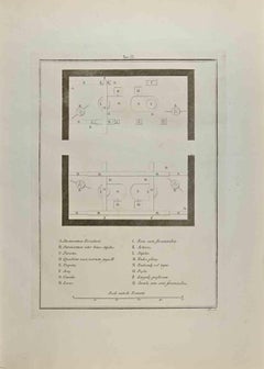
Antique print titled 'Paliacatta'. Plan of the fortified trading settlement of Paliacatta, present day Pulicat in Tamil Nadu, on the Coromandel coast of southeast India. Originates from Awnsham
John Churchill's 'A Collection of Voyages and Travels'.
Artists and Engravers: Published by Henry Lintot and John Osborne.
Condition: Fair, general age-related toning. Several defects and some staining (slightly affecting image). Please study image carefully.
Date: 1744
Overall size: 40 x 34 cm.
Image size: 35 x 28 cm.
We sell original antique maps to collectors, historians, educators and interior decorators all over the world. Our collection includes a wide range of authentic antique maps from the 16th to the 20th centuries. Buying and collecting antique maps is a tradition that goes back hundreds of years. Antique maps have proved a richly rewarding investment over the past decade, thanks to a growing appreciation of their unique historical appeal. Today the decorative qualities of antique maps are widely recognized by interior designers who appreciate their beauty and design flexibility. Depending on the individual map, presentation, and context, a rare or antique map can be modern, traditional, abstract, figurative, serious or whimsical. We offer a wide range of authentic antique maps for any budget.
- Dimensions:Height: 13.39 in (34 cm)Width: 15.75 in (40 cm)Depth: 0 in (0.01 mm)
- Materials and Techniques:
- Period:
- Date of Manufacture:1744
- Condition:Condition: Fair, general age-related toning. Several defects and some staining (slightly affecting image). Please study image carefully.
- Seller Location:Langweer, NL
- Reference Number:Seller: BGJC-00253 1stDibs: LU3054329263402
About the Seller
5.0
Recognized Seller
These prestigious sellers are industry leaders and represent the highest echelon for item quality and design.
Platinum Seller
Premium sellers with a 4.7+ rating and 24-hour response times
Established in 2009
1stDibs seller since 2017
2,811 sales on 1stDibs
Typical response time: 1 hour
- ShippingRetrieving quote...Shipping from: Langweer, Netherlands
- Return Policy
More From This Seller
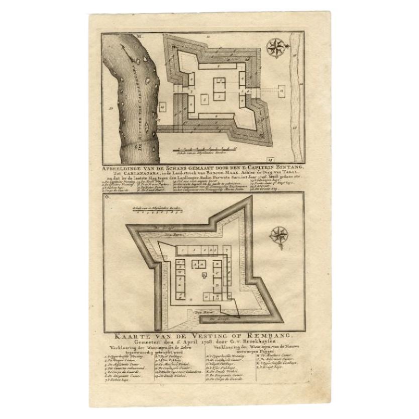
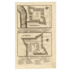
View AllAntique Map of the Fortress of Captain E. Bintang by Valentijn, 1726
Located in Langweer, NL
Antique print titled 'Kaarte van de Schans gemaakt door den E. Capitein Bintang. Kaarte van de Vesting op Rembang.' A plan of the fort constructed by the Captain E. Bintang, in the B...
Category
Antique 18th Century Maps
Materials
Paper
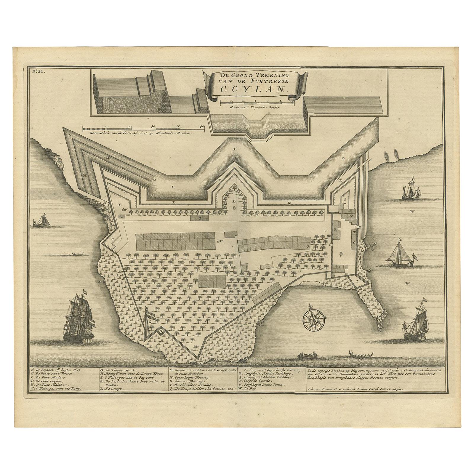
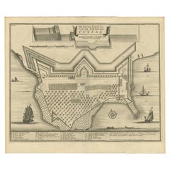
Antique Print of the Fort at Kollam ‘India’ by Valentijn, 1726
By F. Valentijn
Located in Langweer, NL
Antique print titled 'De Grond Tekening van de Fortresse Coylan'. Bird's-eye plan of the fort at Kollam, along the Malabar coast of India. This print ori...
Category
Antique Early 18th Century Dutch Prints
Materials
Paper
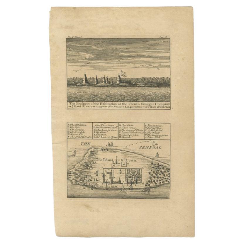
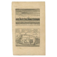
Antique Plan and View of Saint-Louis, Senegal, Africa, 1746
Located in Langweer, NL
Antique print titled ‘The Prospect of the Habitation of the French Senegal Company’. Plan and view of Saint-Louis, Senegal, Africa. This print originates from 'A Collection of Voyage...
Category
Antique 18th Century Prints
Materials
Paper
Antique Engraving of a Bird
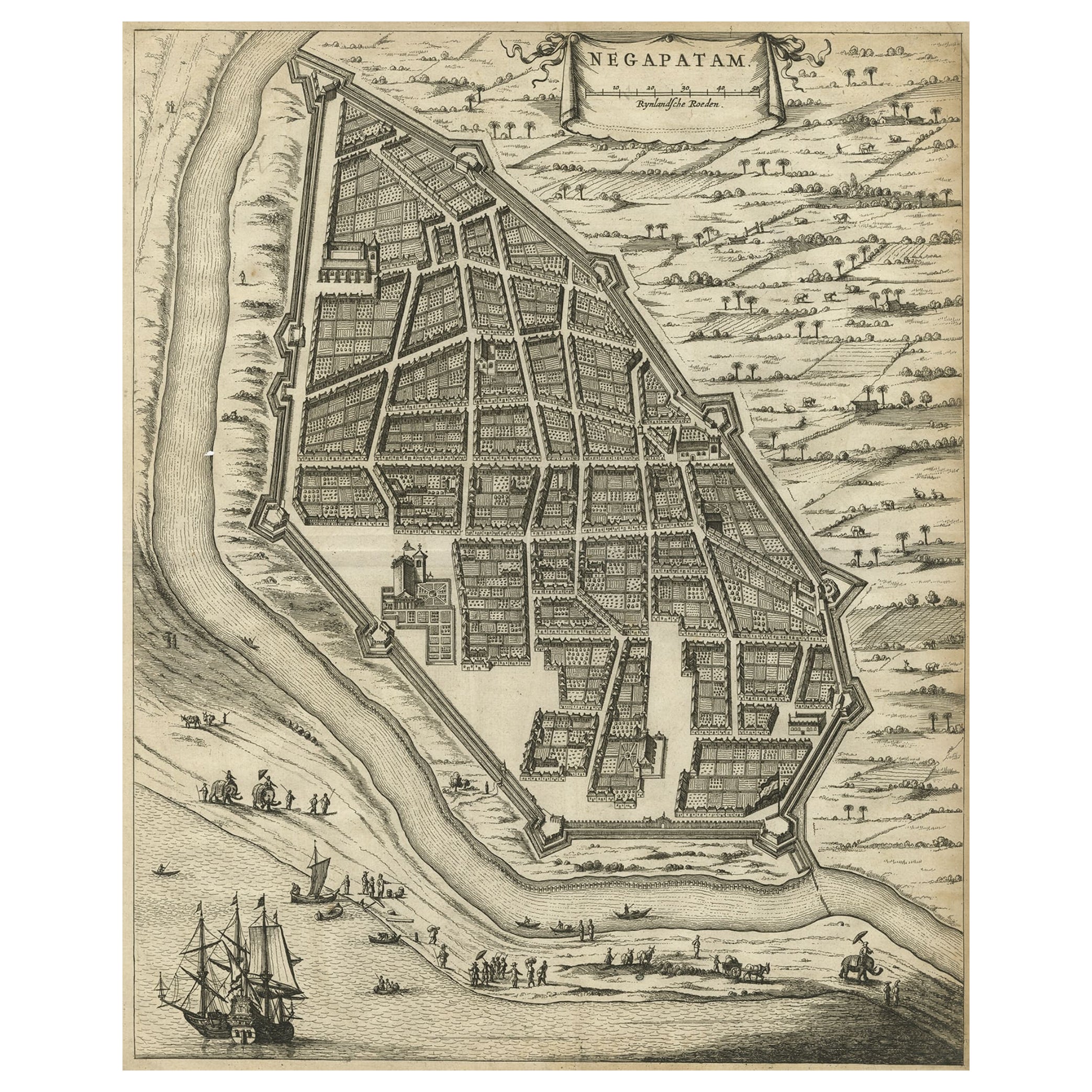
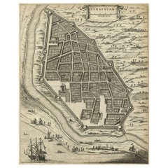
s-Eye Plan of Nagapattinam or Negapatam, India, 1672
Located in Langweer, NL
Antique map titled 'Negapatam.'
Bird's-eye plan of Nagapattinam or Negapatam, India. This map originates from 'Naauwkeurige Beschryvinge van Malabar en Choromandel…en het machtige ...
Category
Antique 1670s Maps
Materials
Paper
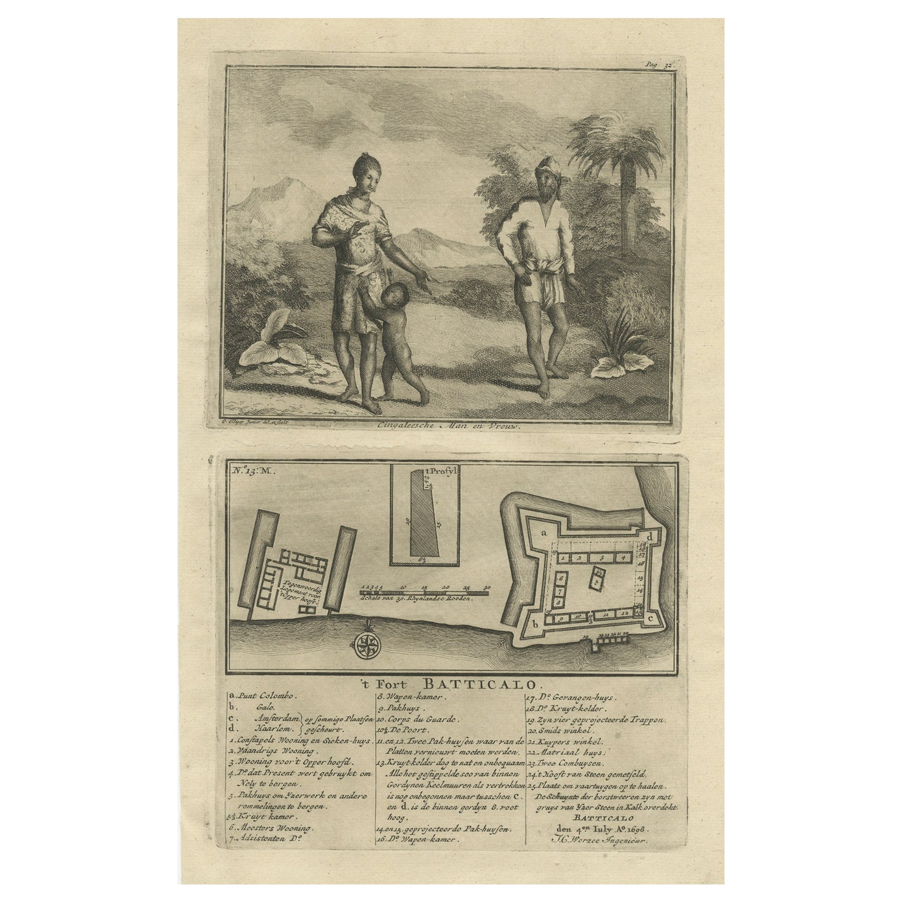
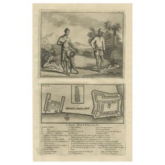
Old Print of the Fort at Batticaloa in the Eastern Province Sri Lanka (Ceylon)
Located in Langweer, NL
Antique print titled 't Fort Batticalo'. Old print depicting a Sinhalese man and woman and the Fort at Batticaloa, India. This print originates from 'Oud en Nieuw Oost-Indiën' by F. ...
Category
Antique 18th Century Prints
Materials
Paper
$422 Sale Price
20% Off
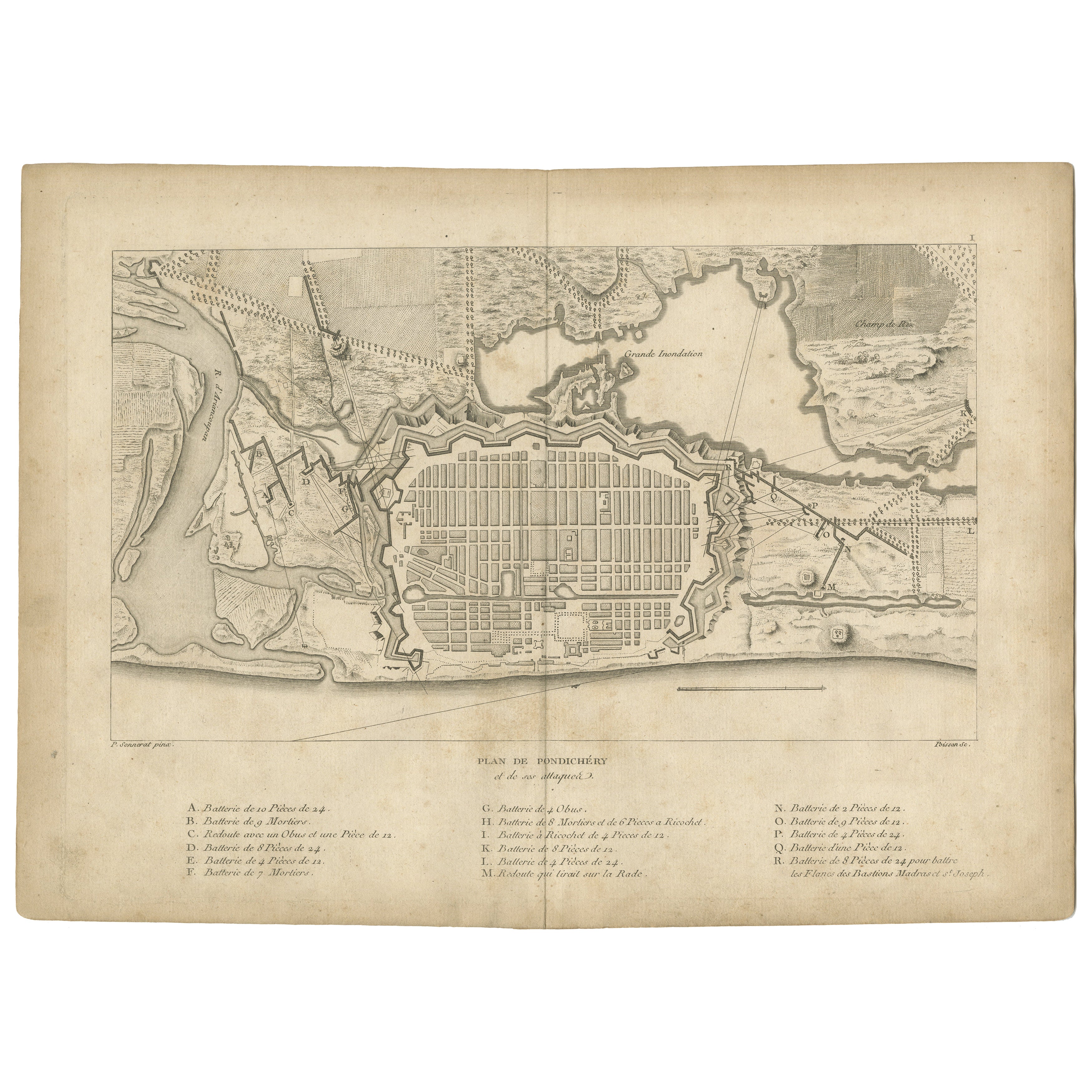
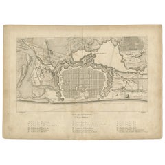
Plan of Pondicherry Fortifications and Attacks, France, c.1750
Located in Langweer, NL
Plan of Pondicherry Fortifications and Attacks, France, c.1750
This finely engraved map depicts the fortified city of Pondicherry, titled "Plan de Pondichéry et de ses attaques." It...
Category
Antique Mid-18th Century French Maps
Materials
Paper
You May Also Like
Original Antique Map or City Plan of Geneva, Switzerland. Circa 1835
Located in St Annes, Lancashire
Nice map of Geneva
Drawn and engraved by J.Dower
Published by Orr & Smith. C.1835
Unframed.
Free shipping
Category
Antique 1830s English Maps
Materials
Paper

Map Of India - Original Lithograph - 19th Century
Located in Roma, IT
Map of India is an original lithograph artwork realized by an Anonymous engraver of the 19th Century.
Printed in the series of "France Pittoresque".
Titled "France Pittoresque".
...
Category
19th Century Modern Figurative Prints
Materials
Lithograph

Antique Voc Print Holland Malaysia Old Map Melaka History, 1663
Located in Amsterdam, Noord Holland
From my own collection I offer this impressive Antique print of the city of Malakka
A very interesting piece for collectors . It is an museum piece from the Dutch Institute of Orien...
Category
Antique 17th Century European Paintings
Materials
Paper

$293 Sale Price
20% Off
Architectural Roman Map - Etching by Vincenzo Scarpati - 18th Century
Located in Roma, IT
Architectural Roman Map from "Antiquities of Herculaneum" is an etching on paper realized by Vincenzo Scarpati in the 18th Century.
Signed on the plate.
Go...
Category
18th Century Old Masters Figurative Prints
Materials
Etching

Map - Etching by Nicola Fiorillo - 18th Century
Located in Roma, IT
Map from "Antiquities of Herculaneum" is an etching on paper realized by Nicola Fiorillo in the 18th Century.
Signed on the plate.
Good conditions with some folding and foxing.
Th...
Category
18th Century Old Masters Figurative Prints
Materials
Etching
Plan of Port Siagi - Etching by Joseph Roux - 1795
Located in Roma, IT
Plan of Port Siagi is al colored etching realized by Joseph Roux in 1795.
The title at the top " Plan du Port Siagi"
Passepartout included: 34 x 49
The artwork is hand water-color...
Category
1790s Modern Figurative Prints
Materials
Etching

More Ways To Browse
Gilded Age Furniture
Grand Rapids Used Office Furniture
Griffin Dining Table
Haddon Hall Furniture
Hanging Cabinet Mahogany
Henry Ford Museum
Hindu Statues
Hoopoe Birds
Italian Olive Jar
Ivory Inlay Furniture
Jacobean Panel
Jade Bi
Japanese Bonsai
Japanese Kimono Antiques
Japanese Marquetry
Japanese Root
Japanese Screens Large
Joe Colombo For Kartell