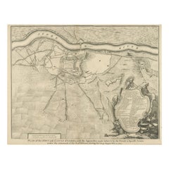
Items Similar to Antique Plan of the Siege of the Castle of Cardona in 1714

Want more images or videos?
Request additional images or videos from the seller
1 of 6
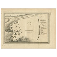
Antique Plan of the Siege of the Castle of Cardona in 1714
$326.39
$407.9920% Off
£241.87
£302.3420% Off
€272
€34020% Off
CA$446.08
CA$557.6020% Off
A$485.59
A$606.9920% Off
CHF 257.75
CHF 322.1920% Off
MX$5,842.71
MX$7,303.3920% Off
NOK 3,266.07
NOK 4,082.5920% Off
SEK 2,992.64
SEK 3,740.8120% Off
DKK 2,071.91
DKK 2,589.8820% Off
About the Item
Antique print titled 'Plan of Cardona a strong city and castle of Catalonia, upon the river Cardoner as besieged by the French and defended by the Allies'. A plan of the siege of the Castle of Cardona in 1714, towards the end of the War of the Spanish Succession, after the Treaty of Utrecht had removed Britain from the hostilities. Built by Wilfred the Hairy in 886, the French bombardment destroyed much of the walls. The fall of Cardona and Barcelona soon after ended Catalan hopes for independence from Spain.
Nicholas Tindal (1687-1774), at one time Chaplain to Greenwich Hospital, first published a translation of Frenchman Paul de Rapin's 'History of England' in 1727, running to thirteen volumes; in 1732 it was enlarged with his own notes and maps. This map was published in 'A summary of Mr Rapin de Thoyras's History of England, and Mr Tindal's Continuation, from the Invasion of Julius Caesar, to the End of the Reign of King George I. Illustrated With Medals, Plans of Battles, Towns, and Sieges', 1751.
- Dimensions:Height: 15.67 in (39.8 cm)Width: 18.9 in (48 cm)Depth: 0.02 in (0.5 mm)
- Materials and Techniques:
- Period:
- Date of Manufacture:1751
- Condition:Age-related toning. Original folding line. Shows some wear, soiling and staining. Blank verso. Please study image carefully.
- Seller Location:Langweer, NL
- Reference Number:Seller: BG-13432-51stDibs: LU3054335982042
About the Seller
5.0
Recognized Seller
These prestigious sellers are industry leaders and represent the highest echelon for item quality and design.
Platinum Seller
Premium sellers with a 4.7+ rating and 24-hour response times
Established in 2009
1stDibs seller since 2017
2,819 sales on 1stDibs
Typical response time: 1 hour
- ShippingRetrieving quote...Shipping from: Langweer, Netherlands
- Return Policy
More From This Seller
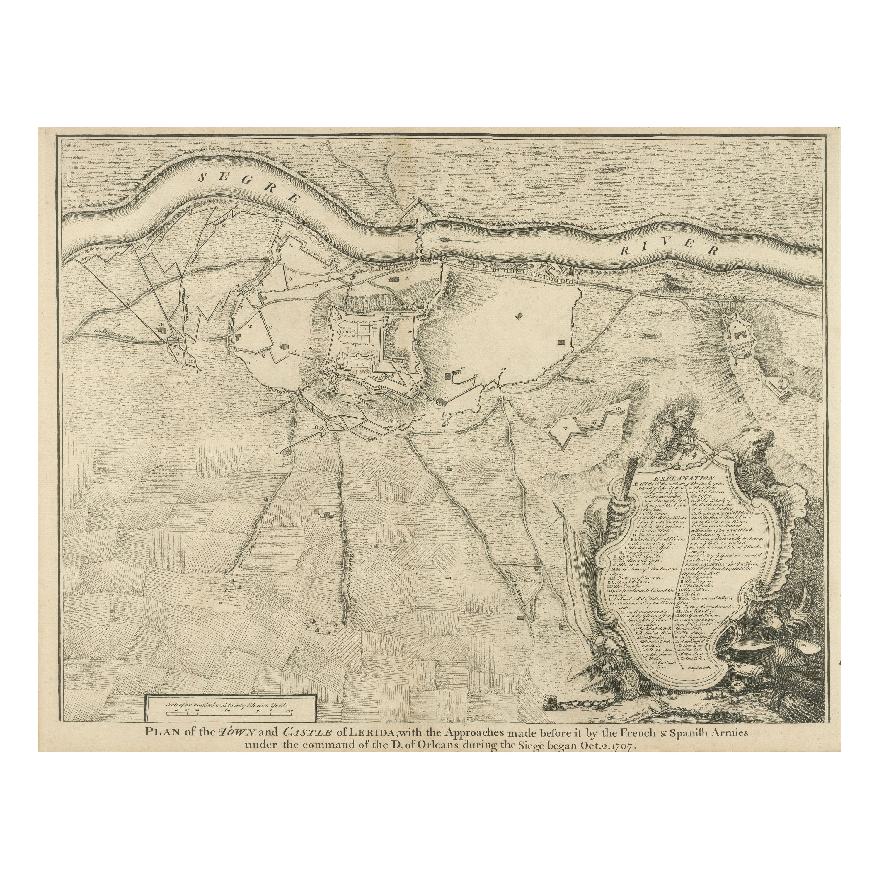
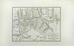
View AllAntique Plan of the Fortifications of Lleida, Spain
Located in Langweer, NL
Antique print titled 'Plan of the Town and Castle of Lerida, with the Approaches Made Before It by the French & Spanish Armies Under the Command of the D. of Orleans During the Siege...
Category
Antique Mid-18th Century Prints
Materials
Paper
$422 Sale Price
20% Off
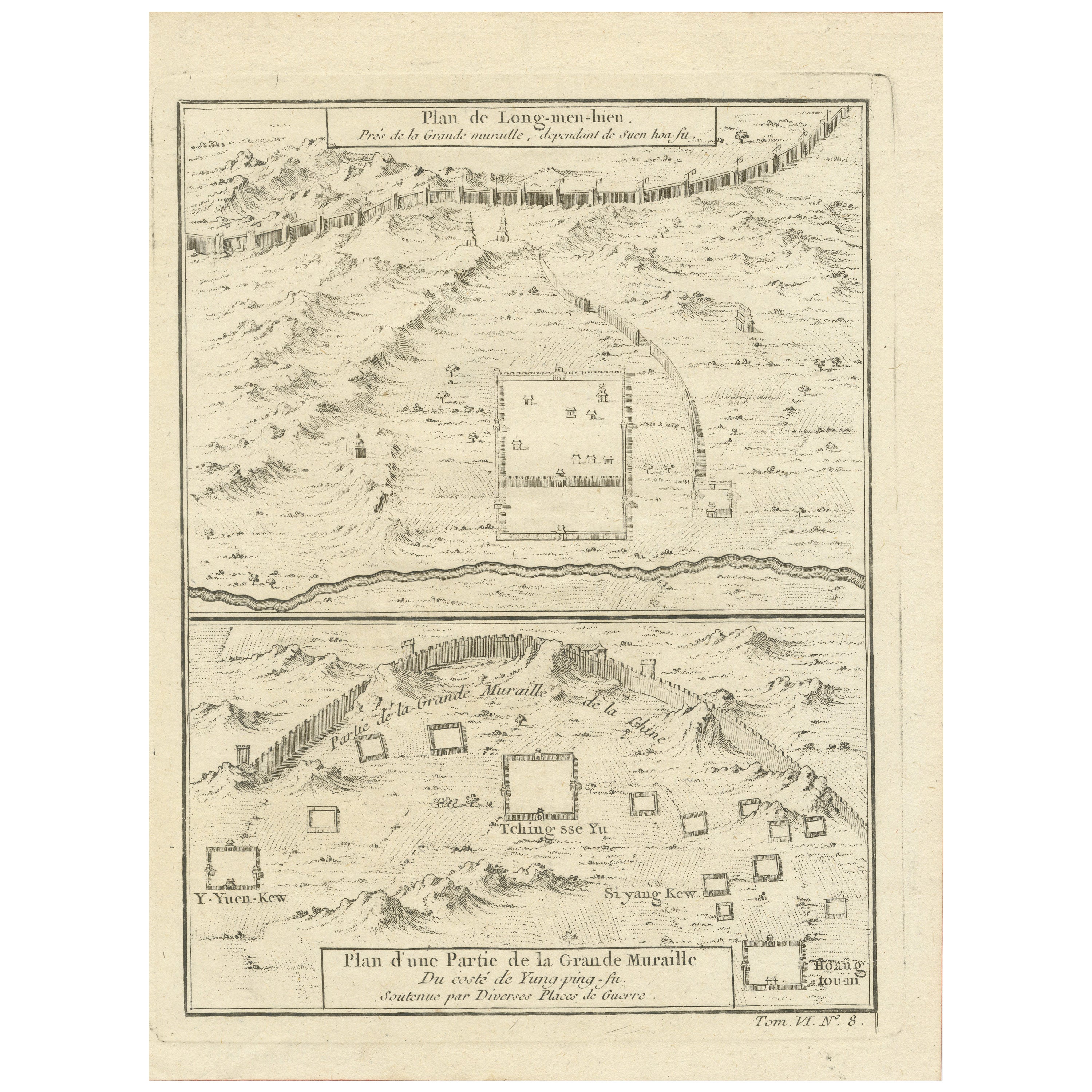
1749 Jacques Nicolas Bellin Map of the Great Wall of China Near Kiang-nan fu
Located in Langweer, NL
This original antique image is an historical map by Jacques Nicolas Bellin, depicting the Great Wall of China as it was understood in the mid-18th century.
The map includes French ...
Category
Antique 1750s Prints
Materials
Paper

$143 Sale Price
20% Off
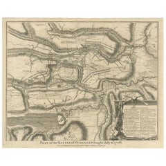
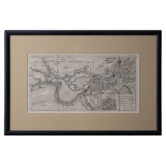
Antique Print of the Battle of Oudenard by I. Basire, 1751
Located in Langweer, NL
Plan of the Battle of Oudenard, fought during the war of the Spanish Succession (1701-1714), in which the Allies, led by Marlborough and Prince Eugene of Savoy, beat the French under the leadership of Louis Joseph, duc de Vendôme, and Louis, duc de Bourgogne (later the Dauphin, but died of measles at 29). The French commanders had quarrelled, resulting in a divided force that was easily beaten. Nicholas Tindal (1687-1774), at one time Chaplain to Greenwich Hospital...
Category
Antique Mid-18th Century Prints
Materials
Paper
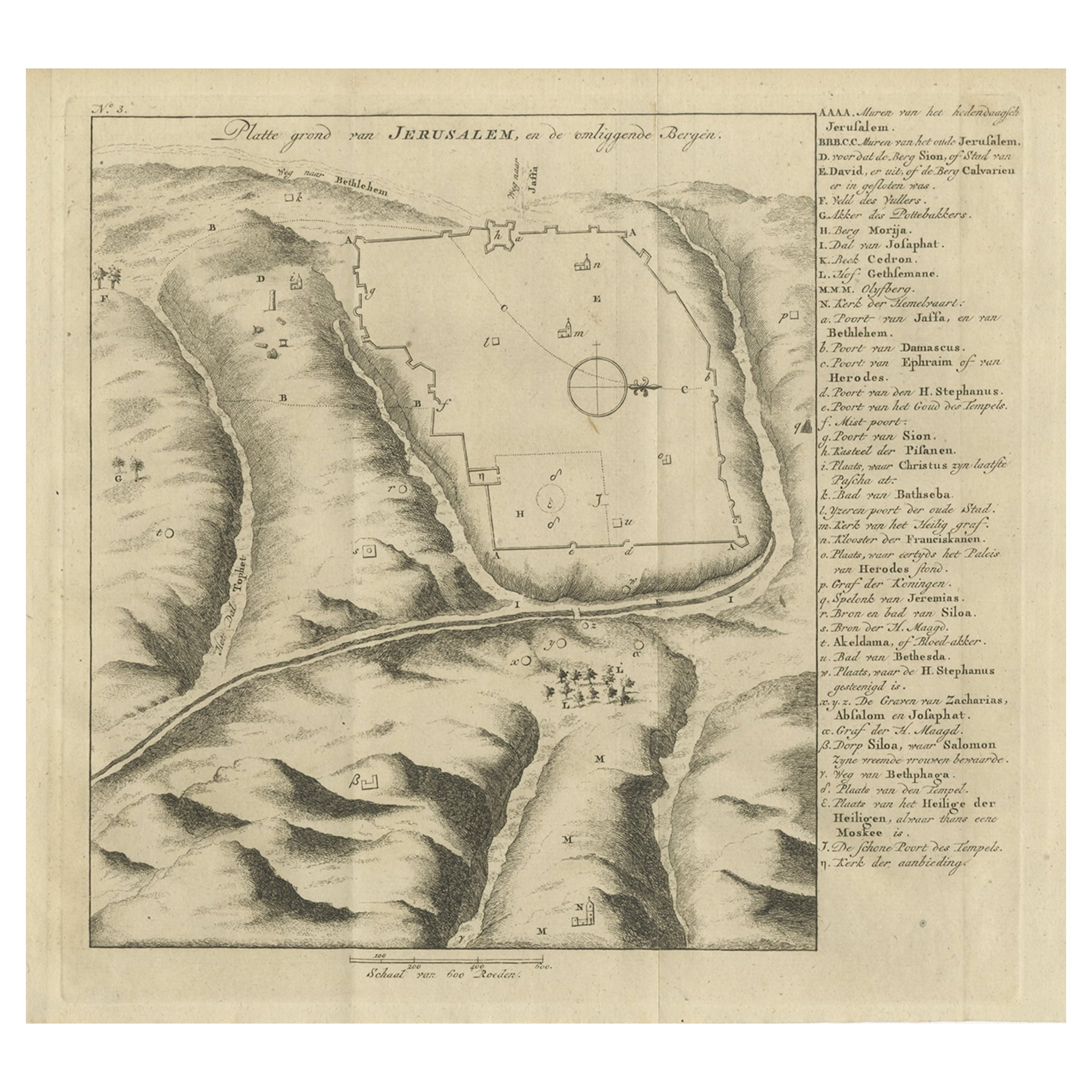
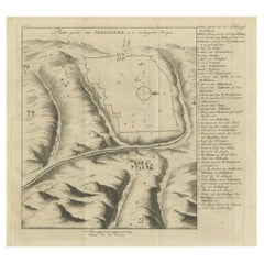
Antique Engraving of a Map or Plan of Jerusalem and Surrounding Mountains, 1773
Located in Langweer, NL
Antique map titled 'Platte grond van Jerusalem, en de omliggende Bergen'. Plan of the city of Jerusalem, with surrounding mountains. Originates from the first Dutch editon of an inte...
Category
Antique 18th Century Maps
Materials
Paper
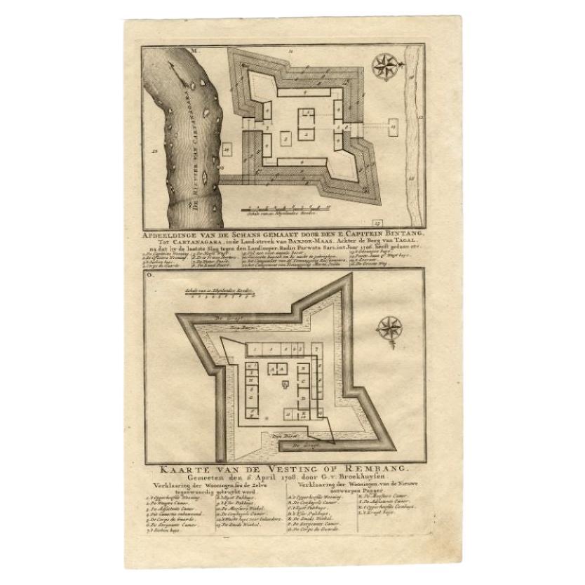
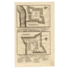
Antique Map of the Fortress of Captain E. Bintang by Valentijn, 1726
Located in Langweer, NL
Antique print titled 'Kaarte van de Schans gemaakt door den E. Capitein Bintang. Kaarte van de Vesting op Rembang.' A plan of the fort constructed by the Captain E. Bintang, in the B...
Category
Antique 18th Century Maps
Materials
Paper
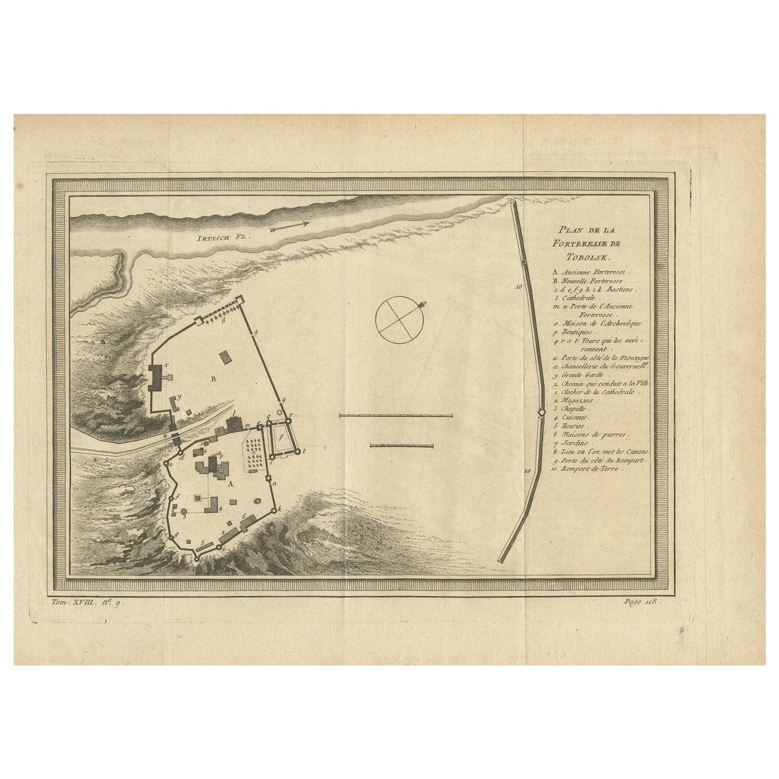
Antique Plan of the Fortress of Tobolsk by Bellin
1768
Located in Langweer, NL
Antique map titled 'Plan de la Forteresse de Tobolsk'. Original plan of the Fortress of Tobolsk, a town in Tyumen Oblast, Russia. Engraved by J.N. Bellin ...
Category
Antique Mid-18th Century Maps
Materials
Paper
$191 Sale Price
20% Off
You May Also Like
Battle of Grocka Campaign Map, 1753 - James Oglethorpe, John Lindsay, Henry Köpp
Located in Savannah, GA
A campaign map of the Battle of Grocka, 1753.
Drawn and engraved by Henry Köpp for the journals of John Lindsay, 20th Earl of Crawford and dedicated to James Oglethorpe.
sight:...
Category
Antique 1750s British Prints
Materials
Glass, Wood, Paper
Map Of The City Of Geneva, Framed Engraving, Late 18th Century
Located in MARSEILLE, FR
Beautiful engraving representing the city of Geneva corrected in 1775 and 1793
The engraving also presents inserts with the evolution of the city, the plan of ancient Geneva and ...
Category
Antique Late 18th Century Swiss Louis XV Prints
Materials
Paper

Li Governi di Borgogna - Ancient Map - 1777
Located in Roma, IT
Li Governi di Borgogna is an original black and white etching on paper, printed by Antonio Zatta in Venice, 1777.
Original Title: Li Governi di Borgogna della Franca Contea e del Ly...
Category
1770s Modern Landscape Prints
Materials
Etching

Original Antique Map or City Plan of Geneva, Switzerland. Circa 1835
Located in St Annes, Lancashire
Nice map of Geneva
Drawn and engraved by J.Dower
Published by Orr & Smith. C.1835
Unframed.
Free shipping
Category
Antique 1830s English Maps
Materials
Paper

Map of Battle of Smolensk - Etching by Pierre François Tardieu - 1837
Located in Roma, IT
Map of Battle of Smolensk is an Etching realized by Pierre François Tardieu in 1837.
Good conditions.
The artwork is realized in a well-balanced composition. the artwork and belong...
Category
1830s Modern Figurative Prints
Materials
Lithograph
1654 Joan Blaeu Map the Sutherland, Scotland, Entitled "Southerlandia, "Ric0007
Located in Norton, MA
1654 Joan Blaeu map of the
Sutherland, Scotland, entitled
"Southerlandia,"
Hand Colored
Ric0007
Description:
Lovely map centered on Sedan and D...
Category
Antique 17th Century Dutch Maps
Materials
Paper

More Ways To Browse
Arne Wahl Iversen Rosewood
Art Deco Clock With Garnitures
Arthur Umanoff Rattan
Atomic Age Art
Aureliano Toso On Sale
Baker Rattan Furniture
Baker Rattan
Beetle Model
Bell Collection
Beyer Vintage
Birds In Flight Sculpture
Blue And Green Majolica
Bombay Company Furniture
Bombay Style Furniture
Boot Scraper
Bronze Rhinoceros
Buffalo China
Burmese Buddha Head