Items Similar to Antique Print of Fort St. Louis Near the Senegal River, circa 1747

Want more images or videos?
Request additional images or videos from the seller
1 of 10
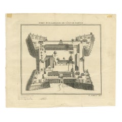
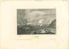
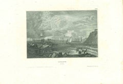
Antique Print of Fort St. Louis Near the Senegal River, circa 1747
$343.32
£256.49
€290
CA$478.06
A$513.64
CHF 275.57
MX$6,051.33
About the Item
Antique print titled 'Plan du Fort St. Louis dans l'Isle de Sanaga ou du Senegal'. Old print with a plan of Fort St. Louis near the Senegal River. This print orginates from 'Histoire Générale des Voyages, ou nouvelle collection de toutes les relations de voyages par mer et par terre'.
Artists and Engravers: Jacques-Nicolas Bellin (1703-1772) was a French hydrographer, geographer and member of The Philosophes. His career, spanning over 50 years, caused an enormous output in maps, particular of maritime interest.
Condition: Good, general age-related toning. Please study image carefully.
Date: circa 1747
Overall size: 36 x 25.8 cm.
Image size: 30.5 x 20.7 cm.
We sell original antique maps to collectors, historians, educators and interior decorators all over the world. Our collection includes a wide range of authentic antique maps from the 16th to the 20th centuries. Buying and collecting antique maps is a tradition that goes back hundreds of years. Antique maps have proved a richly rewarding investment over the past decade, thanks to a growing appreciation of their unique historical appeal. Today the decorative qualities of antique maps are widely recognized by interior designers who appreciate their beauty and design flexibility. Depending on the individual map, presentation, and context, a rare or antique map can be modern, traditional, abstract, figurative, serious or whimsical. We offer a wide range of authentic antique maps for any budget.
- Creator:Jacques-Nicolas Bellin (Artist)
- Dimensions:Height: 10.16 in (25.8 cm)Width: 14.18 in (36 cm)Depth: 0.01 in (0.2 mm)
- Materials and Techniques:Paper,Engraved
- Place of Origin:
- Period:
- Date of Manufacture:c.1747
- Condition:Condition: Good, general age-related toning. Please study image carefully.
- Seller Location:Langweer, NL
- Reference Number:Seller: BG-054621stDibs: LU3054329585542
Jacques-Nicolas Bellin
Jacques Nicolas Bellin (1703 –1772) was a French hydrographer (official cartographer) and a geographer. While still a teenager he became the chief cartographer to the French Navy and later to the king of France. Bellin created a large number of maps for Antoine François Prévost's (L'Abbe Prevost) 'Histoire Generale des Voyages', which was a 25 volume publication focused on 17th and 18th century exploration.It was published in French, Dutch and German. He also contributed maps and articles to the 35-volume Encyclopédie edited by Denis Diderot and Jean le Rond d'Alembert. He was part of the group called Philosophes, which included many of the great intellectuals of the Age of Enlightenment, including Voltaire, Rousseau and Montesquieu. Bellin died at Versailles in 1772.
About the Seller
5.0
Recognized Seller
These prestigious sellers are industry leaders and represent the highest echelon for item quality and design.
Platinum Seller
Premium sellers with a 4.7+ rating and 24-hour response times
Established in 2009
1stDibs seller since 2017
2,836 sales on 1stDibs
Typical response time: 1 hour
- ShippingRetrieving quote...Shipping from: Langweer, Netherlands
- Return Policy
More From This Seller
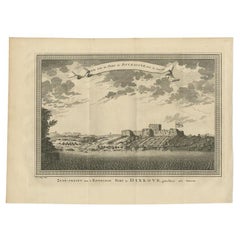
View AllAntique Print of the English Fort at Dixcove in Ghana, 1748
Located in Langweer, NL
Antique print titled 'Vue sud du Fort de Dickscove - Zuid-gezigt van 't Engelsse Fort te Dixkove'. View of the English fort at Dixcove, Ghana. This print originates from 'Historische...
Category
Antique 18th Century Prints
Materials
Paper
$151 Sale Price
20% Off
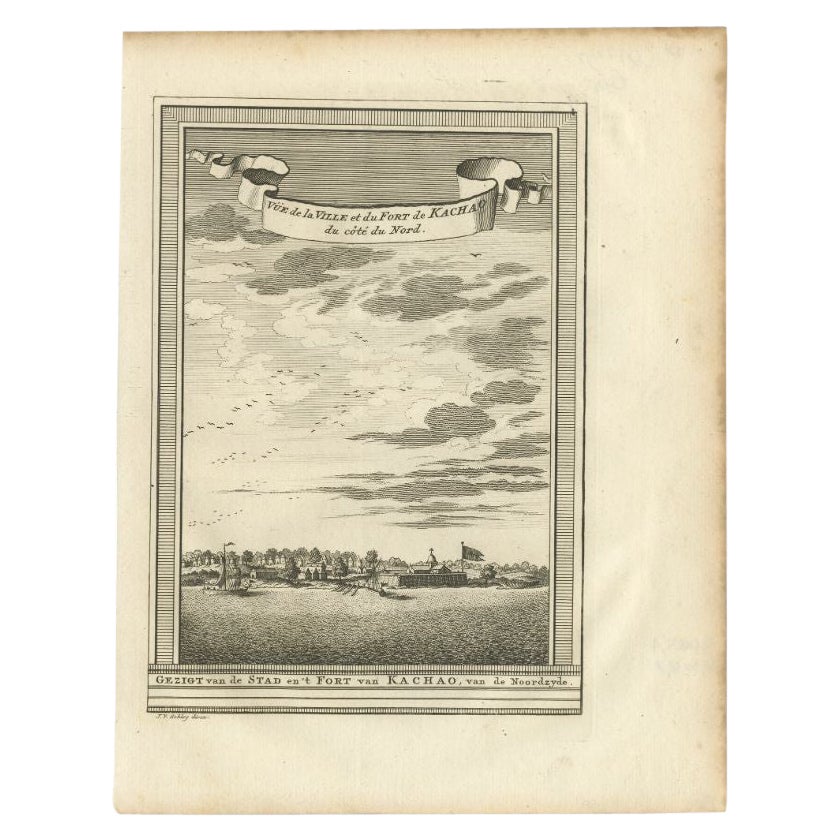
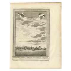
Antique Print of the City and Fortress of Kachao in Guinea Bissau, Africa, 1747
By Jakob van der Schley
Located in Langweer, NL
Antique print titled 'Gezigt van de Stad en 't Fort van Kachao'. View of the city and Fortress of Kachao, Guinea Bissau, Africa. Engraved by J. van Schley for a Dutch edition of 'l'H...
Category
Antique 18th Century Prints
Materials
Paper
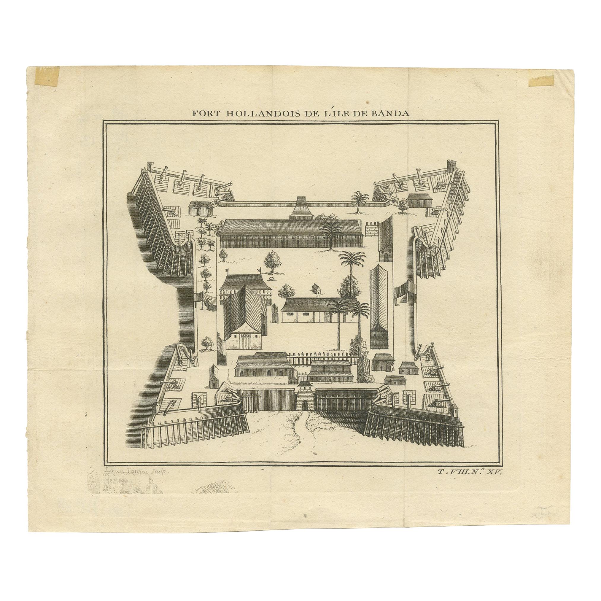
Antique Print of the Dutch Fort on Banda by Tardieu
circa 1750
Located in Langweer, NL
Antique print titled 'Fort Hollandois de l'Ile de Banda'. Engraving of the Dutch VOC fortress Nassau, on Banda Neira, Indonesia. This print originates from '...
Category
Antique Mid-18th Century Prints
Materials
Paper
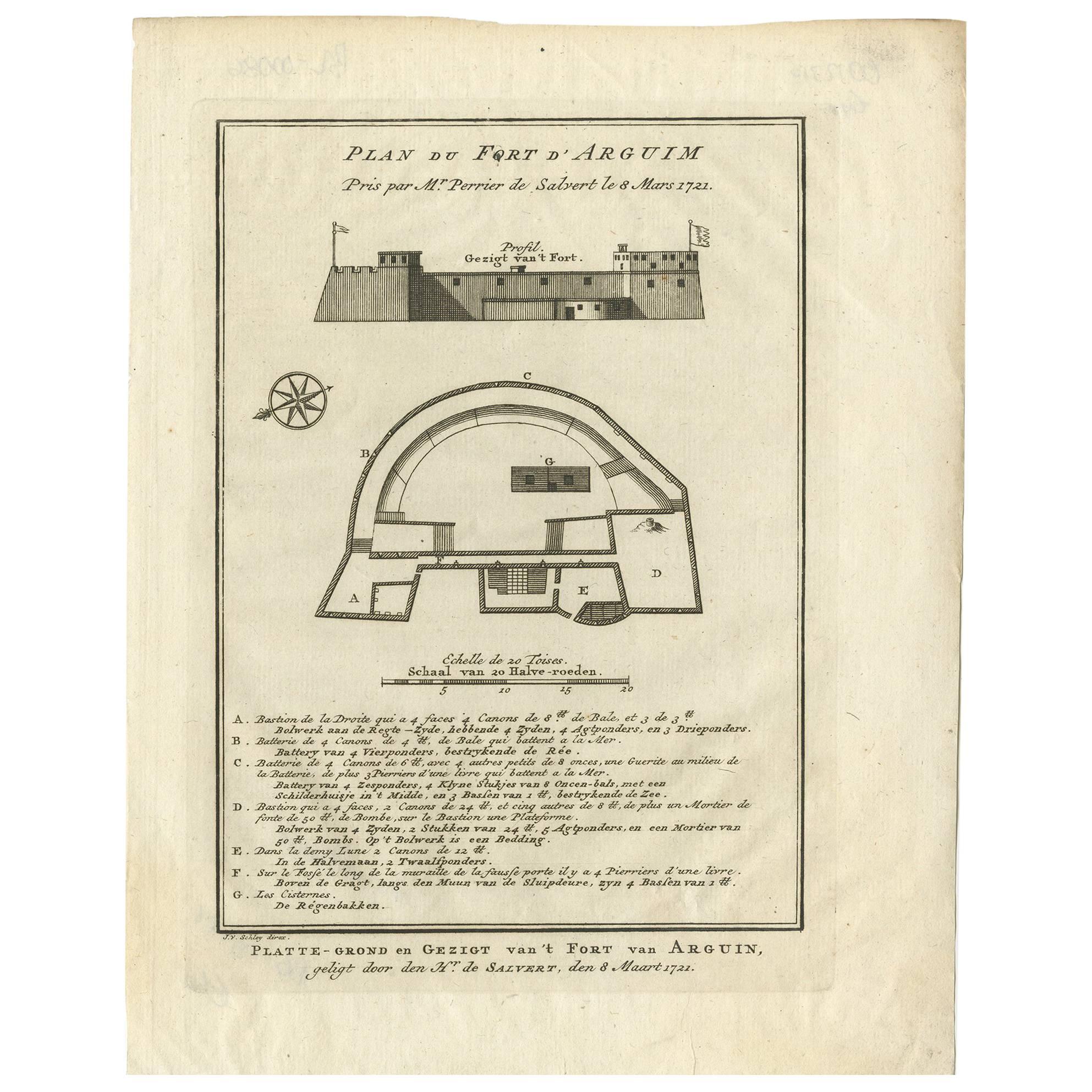
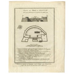
Antique Print of the Fortress of Arguin
Mauritania, Africa, circa 1747
Located in Langweer, NL
Antique print titled 'Platte-Grond en Gezigt van 't Fort van Arguin'. Engraved by J. van Schley. Published in 'Histoire Générale des Voyages (..)', circa 1747.
Category
Antique Mid-18th Century French Prints
Materials
Paper
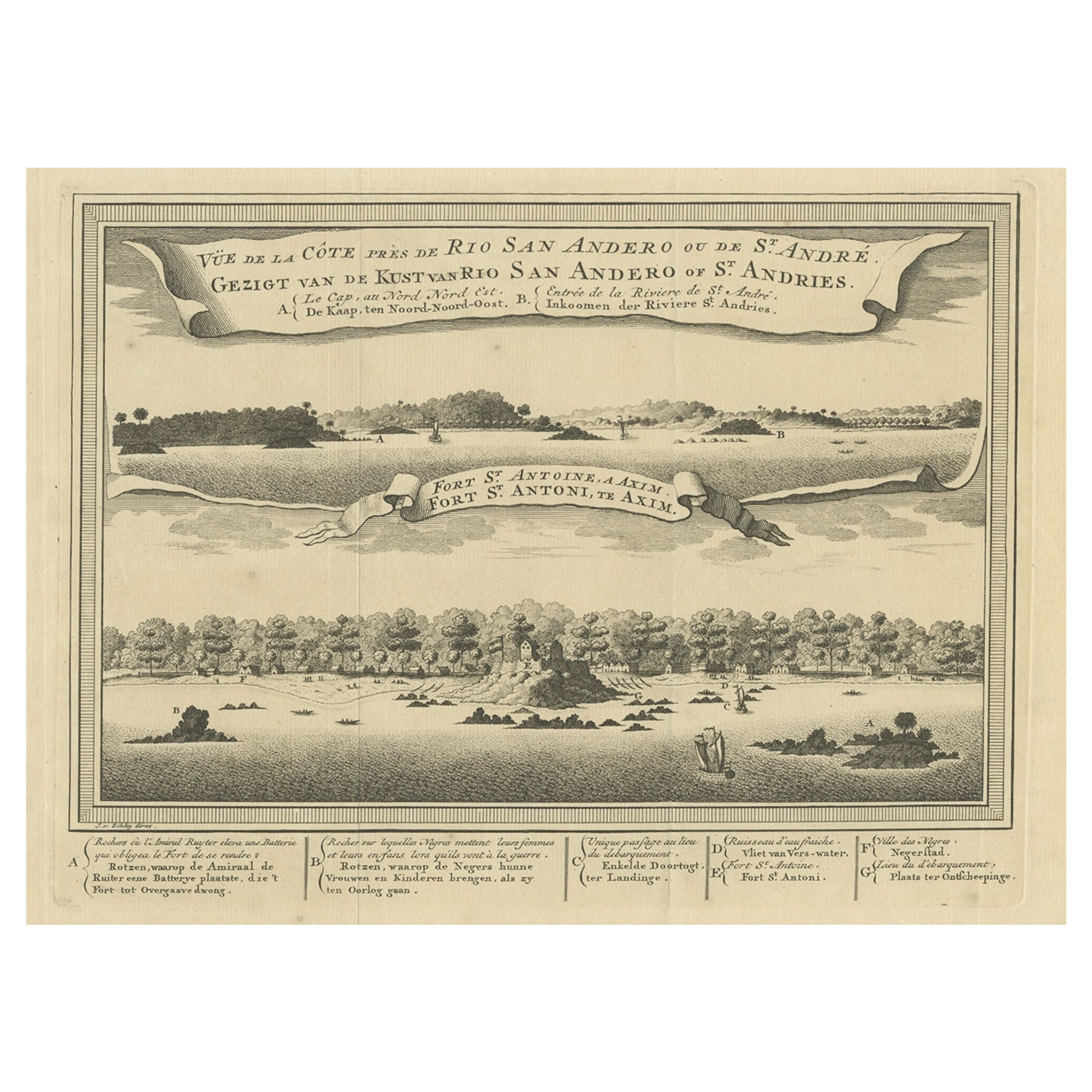
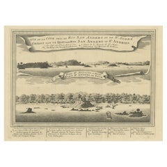
Antique Print of a Fort on the Ivory Coast and Axim, Africa, 1748
By Jakob van der Schley
Located in Langweer, NL
Antique print titled 'Vue de la Cote pres de Rio San Andero - Gezigt van de Kust van Rio San Andero' and 'Fort St. Antoine a Axim - Fort St. Antoni, te Axim'. View of the Ivory coast...
Category
Antique 18th Century Prints
Materials
Paper
$274 Sale Price
20% Off
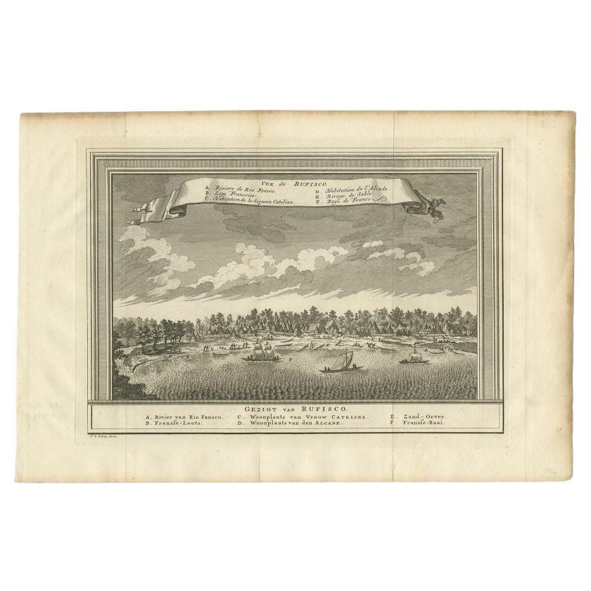
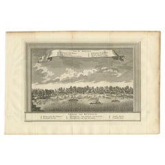
Antique Print with a View of Rufisque, Dakar, Senegal, 1747
By Jakob van der Schley
Located in Langweer, NL
Antique print titled 'Vue de Rufisco - Gezigt van Rufisco'. View of Rufisque, Dakar, Senegal. This print originates from 'Historische beschryving der reizen, of Nieuwe en volkoome ve...
Category
Antique 18th Century Prints
Materials
Paper
You May Also Like
Ancient View of La Valetta - Original Lithograph - Early-19th Century
Located in Roma, IT
La Valetta is an original modern artwork realized in Italy in the first half of the 19th Century.
Original Lithograph on Ivory Paper.
Inscripted in capital letters on the lower ma...
Category
1850s Modern Figurative Prints
Materials
Lithograph
Lithograph View on Nieuw Amsterdam J . Vingboons 1660s
Located in Den Haag, NL
Afther a gouache by J Vingboons 1660s Beautiful Lithograph from 1910/20
Nieuw Amsterdam ofte nue nieuw Lorx opt Teyland Man .
Very nice fresh colors . Comes with a old label on the...
Category
Antique 1650s Dutch American Colonial Prints
Materials
Paper
Architectural Roman Map - Etching by Vincenzo Scarpati - 18th Century
Located in Roma, IT
Architectural Roman Map from "Antiquities of Herculaneum" is an etching on paper realized by Vincenzo Scarpati in the 18th Century.
Signed on the plate.
Go...
Category
18th Century Old Masters Figurative Prints
Materials
Etching

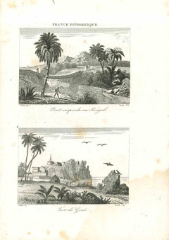
Views of Senegal - Original Lithograph - 19th century
Located in Roma, IT
Views of Senegal is an original lithograph artwork realized by an Anonymous engraver of the 19th century.
Printed in the series of "France Pittoresque".
Titled "France Pittoresqu...
Category
19th Century Modern Figurative Prints
Materials
Lithograph
Print, Handcolored, Copperplate, Engraved, London Bridge, William Maitland, 1739
Located in BUNGAY, SUFFOLK
In original condition. Page 33, 'The History of London from its Foundation by the Romans to the Present Time', by William Maitland, published in 1739....
Category
Antique 18th Century British George II Prints
Materials
Paper
Ancient View of La Valetta - Original Lithograph - Early-19th Century
Located in Roma, IT
La Valetta is an original modern artwork realized in Italy in the first half of the 19th Century.
Original Lithograph on Ivory Paper.
Inscripted in capital letters on the lower ma...
Category
1850s Modern Figurative Prints
Materials
Lithograph
More Ways To Browse
Sword Guard
The President Furniture
Thomas Taylor
Tiger Print Fabric
Tobacco Pot
Torquato Tasso
Usa Stoneware
Used Corian
Used Ethan Allen
Used Hospitality Furniture
Victorian 8 Day Mantel Clock
Victorian Cupid
View In Room
Vintage Childrens Chairs
Vintage Glass Grapes
Vintage Gracie
Vintage Italy Calendar
Vintage Martial Arts