Items Similar to Antique Print of the Town and Fortress of Ternate by Renneville, 1725
Want more images or videos?
Request additional images or videos from the seller
1 of 6
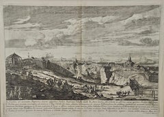
Antique Print of the Town and Fortress of Ternate by Renneville, 1725
$347.37
£259.76
€290
CA$478.59
A$521.97
CHF 276.51
MX$6,257.71
NOK 3,521.46
SEK 3,220.11
DKK 2,209.92
About the Item
Antique print Ternate titled 'La Ville et la Fort de Gamma lamma dans l'isle de Ternade lequel Fort apartient aux Espagnols'. Antique print of the town and fortress of the island of Ternate. Originates from 'Recueil des voyages qui ont servi à l’établissement et aux progrès de la compagnie des Indes orientales (..)'.
Artists and Engravers: Made by or after Rene Augustin Constantin de Renneville. Rene Augustin Constantin de Renneville (1650-1723) a French writer who edited translated Issac Commelin’s Dutch travel accounts.
Condition: Good, general age-related toning. Please study image carefully.
Date: 1725
Overall size: 19 x 16 cm.
Image size: 16 x 13 cm.
Whilst cartography holds a special place in our collection, we also offer thousands of antique prints covering fields of interest as diverse as architecture, natural history, religion, ethnology and many more. Antique prints have long been appreciated for both their aesthetic and investment value. They were the product of engraved, etched or lithographed plates. These plates were handmade out of wood or metal, which required an incredible level of skill, patience and craftsmanship. Whether you have a house with Victorian furniture or more contemporary decor an old engraving can enhance your living space. We offer a wide range of authentic antique prints for any budget.
- Dimensions:Height: 6.3 in (16 cm)Width: 7.49 in (19 cm)Depth: 0 in (0.01 mm)
- Materials and Techniques:
- Period:
- Date of Manufacture:1725
- Condition:
- Seller Location:Langweer, NL
- Reference Number:Seller: BG-093701stDibs: LU3054329311072
About the Seller
5.0
Recognized Seller
These prestigious sellers are industry leaders and represent the highest echelon for item quality and design.
Platinum Seller
Premium sellers with a 4.7+ rating and 24-hour response times
Established in 2009
1stDibs seller since 2017
2,791 sales on 1stDibs
Typical response time: <1 hour
- ShippingRetrieving quote...Shipping from: Langweer, Netherlands
- Return Policy
More From This Seller
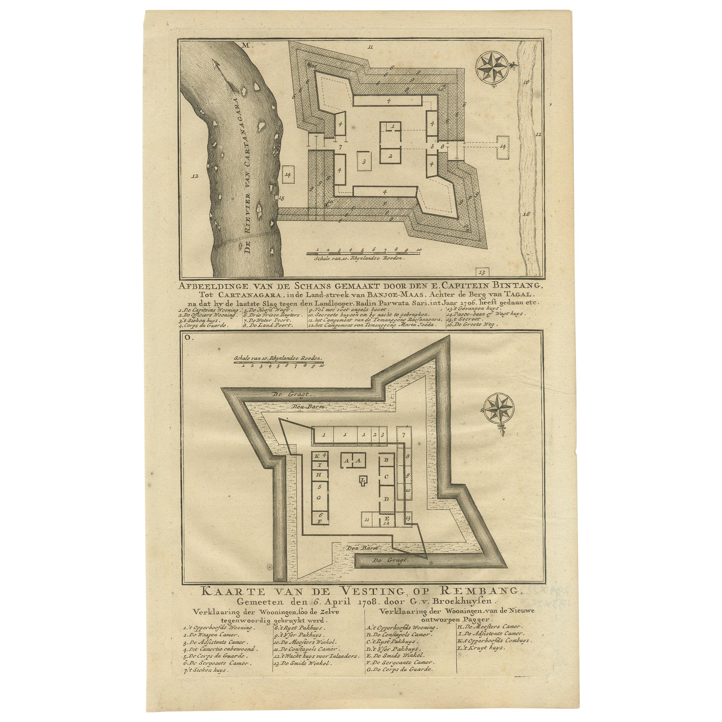
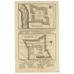
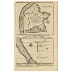
View AllAntique Print of Fortresses in the Banyumas Region by Valentijn, 1726
By F. Valentijn
Located in Langweer, NL
Antique print titled 'Kaarte van de Schans gemaakt door den E. Capitein Bintang. Kaarte van de Vesting op Rembang. ' A plan of the fort constructed by the Captain E. Bintang, in the ...
Category
Antique Mid-18th Century Prints
Materials
Paper
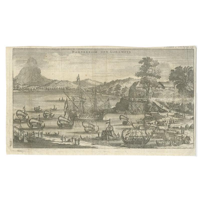
Antique Print of the Fortress of Goram by Schouten, 1725
Located in Langweer, NL
Antique print titled 'Forteresse des Goramois'. View of the fortress of Goram. Originates from 'Voyage de Gautier Schouten aux Indes Orientales (..)'.
...
Category
Antique 18th Century Prints
Materials
Paper
$124 Sale Price
20% Off
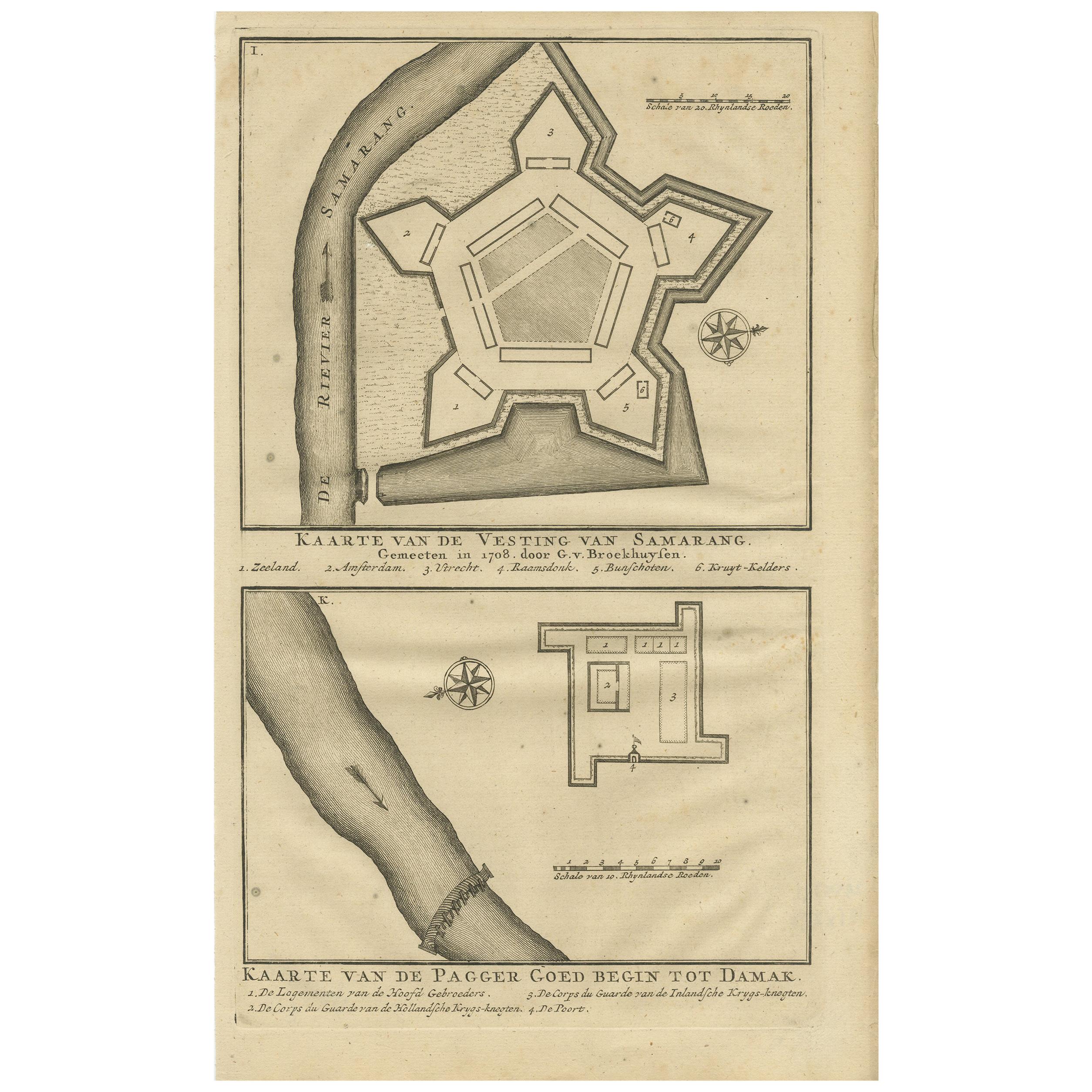
Antique Print of the castle of Semarang and a fortress by Valentijn, 1726
By F. Valentijn
Located in Langweer, NL
Antique print titled 'Kaarte van de Vesting van Samarang. Kaarte van de Pagger Goed begin tot Damak. ' Plans of the castle of Semarang and the fortress (Pagger/Pagar) Demak. From the...
Category
Antique Mid-18th Century Prints
Materials
Paper
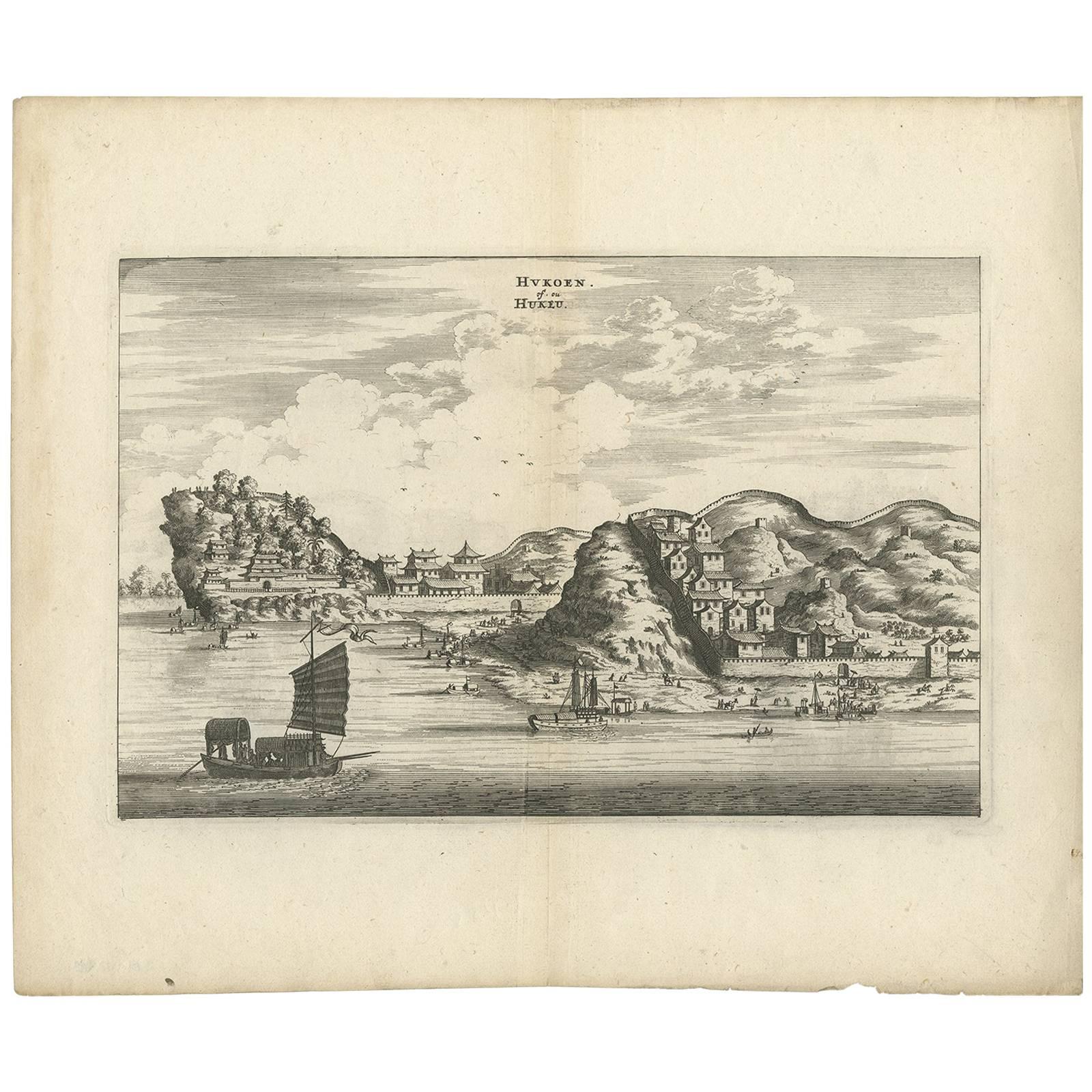
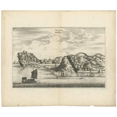
Antique Print of the City of Hukoen
China
by J. Nieuhof, 1666
Located in Langweer, NL
Antique print titled 'Hukoen of Hukeu'. This plate shows a view on the Chinese city of Hukoen with its ramparts. Also depicted are ships. This print originates from a German edition ...
Category
Antique Mid-17th Century Prints
Materials
Paper
$268 Sale Price
20% Off
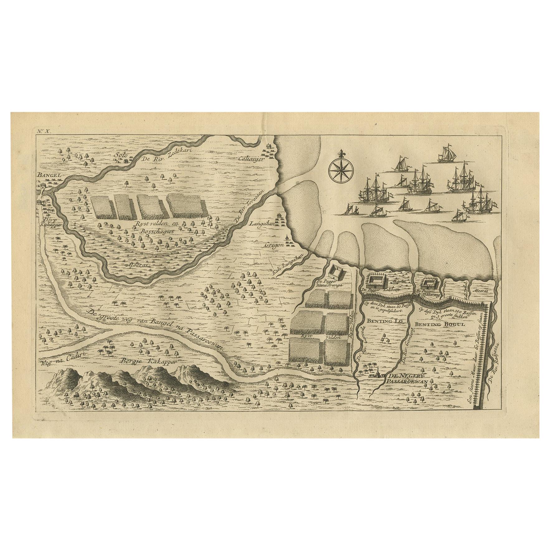
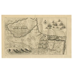
Antique Print of the Region around Pasuruan Indonesia by Valentijn, 1726
Located in Langweer, NL
Antique print of the region around Pasuruan near Surabaya, Indonesia. It shows the location of rice fields, the village Bangil, as well as three places named Pagger (also Pagar), a cluster of buildings surrounded by a bamboo fence. The location of a earthen wall with pallisade and small cannons...
Category
Antique Mid-18th Century Dutch Prints
Materials
Paper
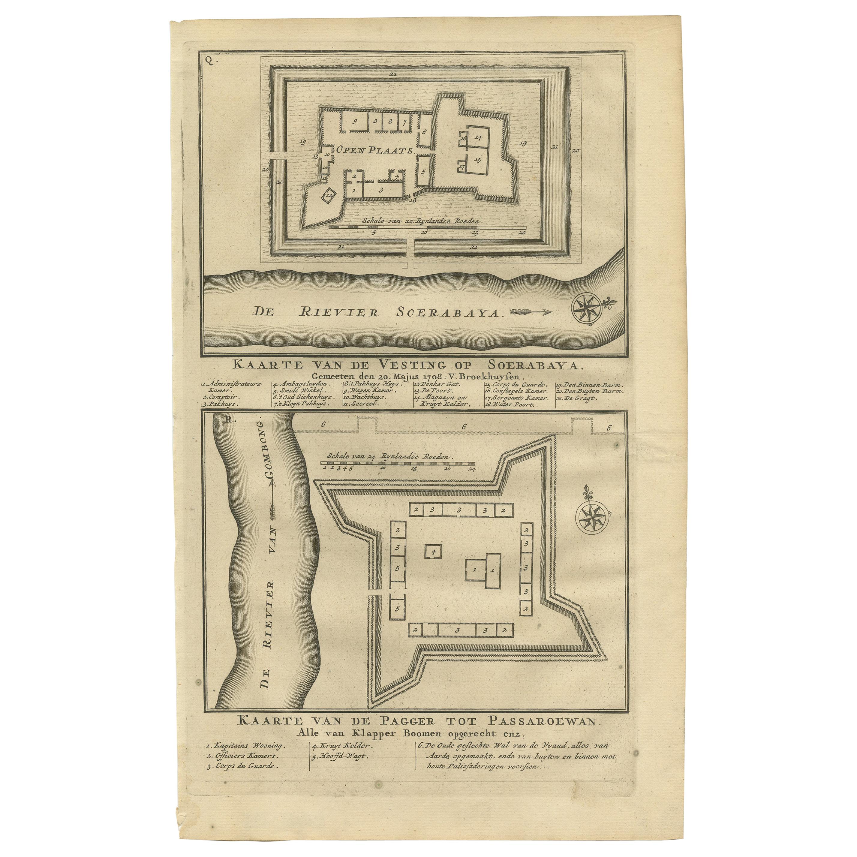
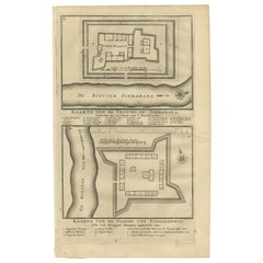
Antique Print of the Fortress on Surabaya and Pasuruan by Valentijn, 1726
Located in Langweer, NL
Antique print titled 'Kaarte van de vesting op Soerabaya. Kaarte van de Pagger tot Passaroewan. ' A plan of the fortress on Surabaya, and a plan of the fo...
Category
Antique Mid-18th Century Prints
Materials
Paper
$95 Sale Price
20% Off
You May Also Like
Antique Voc Print Holland Malaysia Old Map Melaka History, 1663
Located in Amsterdam, Noord Holland
From my own collection I offer this impressive Antique print of the city of Malakka
A very interesting piece for collectors . It is an museum piece from the Dutch Institute of Orien...
Category
Antique 17th Century European Paintings
Materials
Paper

$293 Sale Price
20% Off
17th Century Topographical Engraving Nantes
St. Malo, France, by Iohan Peeters
Located in New York, NY
The ancient city of Saint Malo in North Western France has long been associated with adventure on the high seas, piracy and exploration. It was the birthplace of several important in...
Category
Antique 17th Century Dutch Maps
Materials
Paper

17th Century Toulouse, Savve, Sommieres Topographical Map by Iohan Peeters
Located in New York, NY
Fine topographical 17th century map of Toulouse, Savve and Sommieres by Iohan Peeters
Beautiful engraving of the capital of France's Occitanie Region, Toulouse, called La Ville Rose- the Pink City, for the terracotta bricks used in its many buildings, giving the city a distinct apricot-rose hue. An important cultural and educational center, the city's residents included Nobel Prize winners and world renown artists- Henri de Toulouse-Lautrec, Henri Martin, Jean-Auguste-Dominique Ingres, Antonin Mercie, Alexandre Falguiere and more recently Cyril Kongo...
Category
Antique 17th Century Dutch Maps
Materials
Paper

An Antique Engraved View of Copper Mining in Sweden in the 17th C. by Dahlberg
By Erik Dahlberg
Located in Alamo, CA
This is an antique engraved view entitled "Fodinae aerariae Falunenfis, qui orientem fpectat, delineatio" (Copper mining in Falun), Sweden in 1705 from "Sueciae Antiquae et Hodiernae"' published in Stockholm by Erik Dahlberg (1625-1703). The engraving was created by Johannes van den Aveelen (1650-1727), who was an accomplished copperplate engraver who emigrated to Sweden to work on Dahlberg's spectacular book, "Sueciae Antiquae et Hodiernae", which was focused on the views and architecture of Sweden, both in the ancient past and at the time of the publication.
This engraving depicts a very active 17th century working scene...
Category
Early 18th Century Naturalistic Landscape Prints
Materials
Laid Paper, Engraving
View of the City of Paris from the side of the island called... - Etching - 1748
Located in Roma, IT
Etching on paper realized in 1748.
Very good condition except for some minor foxing.
Includes a wooden frame cm. 27.5x41.5
Category
1740s Modern Abstract Prints
Materials
Etching
18th Century French Map and City View of Joppe/Jaffa (Tel Aviv) by Sanson
By Nicholas Sanson d
Abbeville
Located in Alamo, CA
An original antique engraving entitled "Joppe; in ’t Hebreeusch by ouds Japho; hedendaags Japha, of Jaffa; volgens d’aftekening gedaan 1668", by Nicholas Sanson d'Abbeville (1600 - 1667). This is a view of the city of Joppe (in Hebrew Japho), now called Japha or Jaffa, the harbor portion of modern day Tel Aviv, Israel as it appeared in 1668 . It depicts a very busy harbor with numerous boats. A large ship on the left appears to be firing its canons and a small ship on the right appears to be sitting very low in the water, either heavily loaded with cargo or sinking. The town is seen on the far shore with a fortress on a hill across in the background. The map is printed from the original Sanson copperplate and was published in 1709 by his descendants.
The map is presented in an ornate brown wood frame embellished by gold-colored leaves and gold inner trim with a double mat; the outer mat is cream-colored and the inner mat is black. There is a central vertical fold, as issued. There are two small spots in the lower margin and one in the upper margin, as well as two tiny spots adjacent to the central fold. 1717 is written below the date 1668 in the inscription. The map is otherwise in very good condition.
Another map of the "Holy Land" (by Claes Visscher in 1663), with an identical style frame and mat is available. This pair of maps would make a wonderful display grouping. Please see Reference #LU117324709892.
Artist: Nicholas Sanson d'Abbeville (1600 - 1667) and his descendents were important French cartographer's active through the 17th century. Sanson started his career as a historian and initially utilized cartography to illustrate his historical treatises. His maps came to the attention of Cardinal Richelieu and then King Louis XIII of France, who became a supporter and sponsor. He subsequently appointed Sanson 'Geographe Ordinaire du Roi' the official map maker to the king. Sanson not only created maps for the king, but advised him on geographical issues and curated his map collection...
Category
Early 1700s Prints and Multiples
Materials
Engraving

More Ways To Browse
W Hayes
Walnut 3 Drawer Commode
White Marble Plaques
Wood Paddle
Wood Statue Stand
Wooden Counter
19th Century Puppet
1900 Wicker Furniture
1930s Butterfly
Amitabha Buddha
Antique Beech Chest Of Drawers
Antique Canning Pot
Antique Chestnut Baskets
Antique Chinese Bells
Antique Chinese Jadeite
Antique Clock Ornament
Antique Dog House
Antique Fu Dogs