Want more images or videos?
Request additional images or videos from the seller
1 of 9
Bell Rock Lighthouse: Guardian of Scotland’s Treacherous North Sea Coast, 1790
Price:$200
$272.29List Price
About the Item
- Dimensions:Height: 9.97 in (25.3 cm)Width: 8.08 in (20.5 cm)Depth: 0 in (0.02 mm)
- Materials and Techniques:Paper,Engraved
- Period:1790-1799
- Date of Manufacture:1790
- Condition:Condition: good, given age. Light foxing, browning and general age-related toning and/or occasional minor defects from handling. Original hand-coloring. Please study scan carefully.
- Seller Location:Langweer, NL
- Reference Number:Seller: BG-13825-291stDibs: LU3054341251552
About the Seller
5.0
Recognized Seller
These prestigious sellers are industry leaders and represent the highest echelon for item quality and design.
Platinum Seller
Premium sellers with a 4.7+ rating and 24-hour response times
Established in 2009
1stDibs seller since 2017
2,834 sales on 1stDibs
Typical response time: 1 hour
Authenticity Guarantee
In the unlikely event there’s an issue with an item’s authenticity, contact us within 1 year for a full refund. DetailsMoney-Back Guarantee
If your item is not as described, is damaged in transit, or does not arrive, contact us within 7 days for a full refund. Details24-Hour Cancellation
You have a 24-hour grace period in which to reconsider your purchase, with no questions asked.Vetted Professional Sellers
Our world-class sellers must adhere to strict standards for service and quality, maintaining the integrity of our listings.Price-Match Guarantee
If you find that a seller listed the same item for a lower price elsewhere, we’ll match it.Trusted Global Delivery
Our best-in-class carrier network provides specialized shipping options worldwide, including custom delivery.You May Also Like
Lighthouses by Doug Brega Print (Set of 2)
Located in Medina, OH
Lighthouses by Doug Brega print, this is a listing for a set of (2) framed prints. Doug Brega, a well known American realist artist continues to attract new admirers who recognize t...
Category
1990s American American Colonial Prints
Materials
Wood, Paper
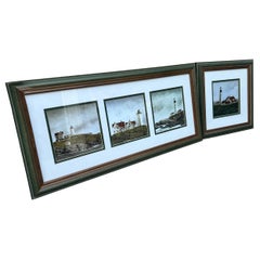
Chart of the East Coast of England
Located in Norwell, MA
Chart of the East Coast of England, from Dungeness to Flamborough, including the entrances to the Thames River. Drawn by hydrographer J.W. Norie in 1841. Includes Kent, Essex and Suf...
Category
Antique 1840s English Nautical Objects
Materials
Paper

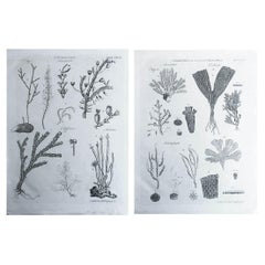
Pair of Original Antique Prints of Corals, C.1790
Located in St Annes, Lancashire
Great images of corals
Copper-plate engravings
Drawn and engraved by A.Bell
Published C.1790
Unframed.
Free shipping.
Category
Antique 1790s English Georgian Prints
Materials
Paper
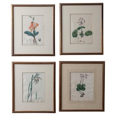
Henry C. Andrews Botanical Prints, c.1790s - set of 4
Located in Savannah, GA
Henry Cranke Andrews
(British, 1759-1835)
A set of four hand-colored botanical engravings published in the 1790s.
14 ¾ by 17 ½ inches
Category
Antique 1790s English Prints
Materials
Glass, Wood, Paper
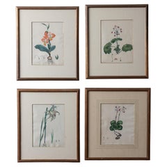
Henry C. Andrews Botanical Prints, c.1790s - set of 4
Located in Savannah, GA
Henry Cranke Andrews
(British, 1759-1835)
A set of four hand-colored botanical engravings published in the 1790s.
14 ¾ by 17 ½ inches
Category
Antique 1790s British Prints
Materials
Glass, Wood, Paper
Set of 4 Original Antique Prints of Monkeys, circa 1790
Located in St Annes, Lancashire
Great images of monkeys
Copper-plate engraving
Published C.1790
Unframed.
Category
Antique 1790s English Georgian Prints
Materials
Paper
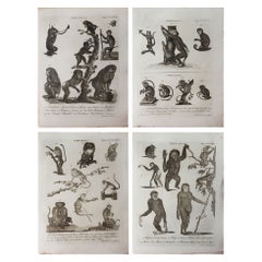
$120 / set
Free Shipping
H 11 in W 8.75 in D 0.07 in
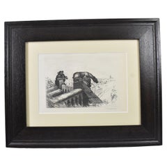
"Guardian of the Spire" Etching by John Taylor Arms
Located in Toledo, OH
This etching by John Taylor Arms is titled "Guardians of the Spire." John Taylor Arms(1887-1953) was a famous printmaker in the early 20th century. This etching features two griffin ...
Category
Vintage 1920s Gothic Revival Prints
Materials
Paper
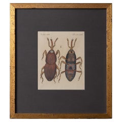
Bertuch Insects Wheat Weevil c. 1790s
Located in Savannah, GA
Friedrich Justin Bertuch
(Germany 1747-1822)
Original handcolored engraving of "The Wheat Weevil” from the volume Harmful Insects of Bilderbuch für Kinder (Picture Book for Chil...
Category
Antique 1790s German Prints
Materials
Glass, Giltwood, Paper
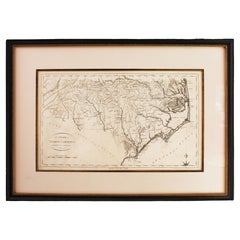
1796 Map of North Carolina by John Reid
Located in Chapel Hill, NC
1796 Map of North Carolina by John Reid. A rare & important early map of the state based on the 1795 Lewis/Carey map for his "An American Atlas". Engraved by Benjamin Tanner. Old pur...
Category
Antique Late 18th Century American Prints
Materials
Paper
Hand Colored Framed Map Print of North Africa
By Abraham Ortelius
Located in Barcelona, ES
Original antique map of North Africa
Antique framed map print titled 'Barbariae et Biledulgerid Nova Descriptio'.
Artist: Abraham Ortelius (1527 -1598)
Published by A. Ortelius, ci...
Category
20th Century European Spanish Colonial Prints
Materials
Giltwood, Paper

More From This Seller
View AllAntique Map of the West Coast of North America
North East Coast of Asia
1772
Located in Langweer, NL
Antique map titled 'Carte des nouvelles decouvertes/ Extrait d'une Carte Japonoise de l'Universe'. Map of the West Coast of North America and North-East Coast of Asia, based upon Buache's report of the various Russian Discoveries between 1731 and 1742 including the various explorers routes and notes. The lower map is based upon a Japanese map...
Category
Antique Late 18th Century Maps
Materials
Paper

$615 Sale Price
20% Off
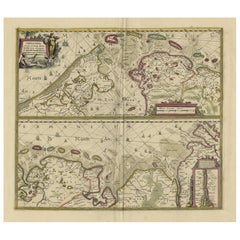
Antique Engraving of Dutch and German North Sea Coast of Friesland, ca.1680
Located in Langweer, NL
Antique map titled 'Tabula Nova In qua accuratè demonstratur tota Navigatio ab Amstelodami Statione per Vada vulgo de Watten Hamburgum usq.' -
Two maps with the Dutch and German North Sea coast of Friesland, with West Frisian Islands and below East Frisian Islands with inset map of the Elbe around Hamburg. With title and a scale cartouche. Map by Henricus Hondius...
Category
Antique 1680s Maps
Materials
Paper
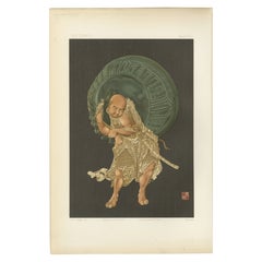
The Guardian of the Bell – An Audsley’s Japanese-Inspired Chromolithograph, 1884
Located in Langweer, NL
Title: The Guardian of the Bell – Plate VIII from G. A. Audsley’s Japanese-Inspired Chromolithographic Series
Description: Plate VIII from Section V of G. A. Audsley’s collection is...
Category
Antique 1880s Prints
Materials
Paper
Antique Print of the North Coast of Gibraltar by F. Appel
c.1890
Located in Langweer, NL
Antique print titled 'Gibraltar (Côte du Nord)'. View of Gibraltar. Published by F. Appel after a painting by Louis Lebreton. Published circa 1890.
Category
Antique Late 19th Century Prints
Materials
Paper
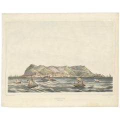
$473 Sale Price
20% Off
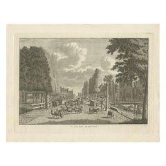
Antique Print of Sint Jacobiparochie, Village in the North of Holland circa 1790
Located in Langweer, NL
Antique print titled 'St. Jacobi Parochie'. Orginal antique print of the village of Sint Jacobiparochie, Friesland, the Netherlands. This print originates from 'Vaderlandsche gezicht...
Category
Antique 18th Century Prints
Materials
Paper
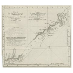
Old Chart of the North-Eastern Coast of Australia Discovered by Cook, 1774
Located in Langweer, NL
Antique print titled Carte d'une Partie de la Cote de la N.le Galles Merid etc.
An interesting chart of the north-eastern coast of Australia discovered by Cook in 1770, showing th...
Category
Antique 1770s Maps
Materials
Paper
$719 Sale Price
20% Off