Items Similar to Charting the West: Surveyor General Roe’s Western Australian Expedition , 1852


Want more images or videos?
Request additional images or videos from the seller
1 of 10
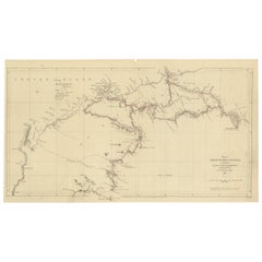
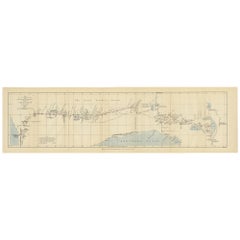
Charting the West: Surveyor General Roe’s Western Australian Expedition , 1852
$277.62
$347.0320% Off
£207.35
£259.1920% Off
€232
€29020% Off
CA$382.47
CA$478.0920% Off
A$416.83
A$521.0420% Off
CHF 220.73
CHF 275.9120% Off
MX$5,006.56
MX$6,258.2020% Off
NOK 2,794.48
NOK 3,493.1020% Off
SEK 2,569.25
SEK 3,211.5620% Off
DKK 1,767.44
DKK 2,209.3020% Off
About the Item
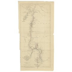
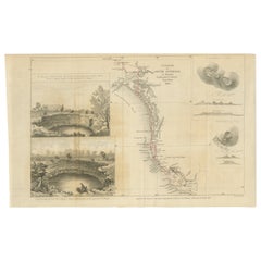
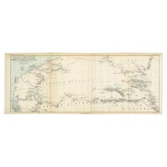
This map is a historical document, focused on Western Australia. It illustrates the route of an expedition under Surveyor General Roe from Perth to Russell Range during 1848 and 1849.
The 1848-1849 expedition of John Septimus Roe to the Russell Ranges stands as a significant chapter in the exploration history of Western Australia. Roe, serving as the first Surveyor General of Western Australia—a role he held for an impressive 43 years—undertook this journey as one of his major exploratory endeavors. His expeditions were pivotal in charting unknown territories and fostering a deeper understanding of the Australian landscape.
During his tenure, Roe was responsible for mentoring future explorers and is often described as the 'Father of Australian Explorers'. His meticulous field notes and sketches from his various expeditions provide a detailed and accurate record of the land as it was during the first contact by European settlers. His observations covered a wide range of aspects, from the landscapes and water sources to the flora and fauna, as well as interactions with Indigenous peoples and their place names.
The expedition to the Russell Ranges was one of Roe's four major explorations, with the others occurring in 1835 to King George Sound, in 1836 to Wongan Hills, and in 1847 to Champion Bay and Hutt River. The complete record of his exploratory work was compiled and published in 2014, ensuring that his contributions to Australian exploration are preserved and accessible for future generations. This comprehensive collection not only includes Roe's field reports but is also enhanced with expert analysis of the region's plant and animal species, and insights into the navigation and surveying techniques of the time.
Roe's work was instrumental in mapping the Australian frontier and his legacies in navigation and exploration continue to be celebrated in Western Australian history.
- Dimensions:Height: 8.47 in (21.5 cm)Width: 16.93 in (43 cm)Depth: 0 in (0.02 mm)
- Materials and Techniques:
- Period:
- Date of Manufacture:1852
- Condition:Good. Thin paper with vertical folds as issued. Light creasing in lower right corner. A light brownish hue, mainly around the edges, adding to its patina. Study the images carefully.
- Seller Location:Langweer, NL
- Reference Number:Seller: BG-13699-31stDibs: LU3054338355732
About the Seller
5.0
Recognized Seller
These prestigious sellers are industry leaders and represent the highest echelon for item quality and design.
Platinum Seller
Premium sellers with a 4.7+ rating and 24-hour response times
Established in 2009
1stDibs seller since 2017
2,788 sales on 1stDibs
Typical response time: <1 hour
- ShippingRetrieving quote...Shipping from: Langweer, Netherlands
- Return Policy
More From This Seller
View AllGregory
s 1861 Expedition into the North West of Australia, 1862
Located in Langweer, NL
The map represents the route taken during F.T. Gregory's 1861 North West Australian Expedition.
This exploration was a significant journey that took place over the Pilbara region, starting from the Ashburton River and extending to the Dampier Archipelago and the De Grey...
Category
Antique 1860s Prints
Materials
Paper
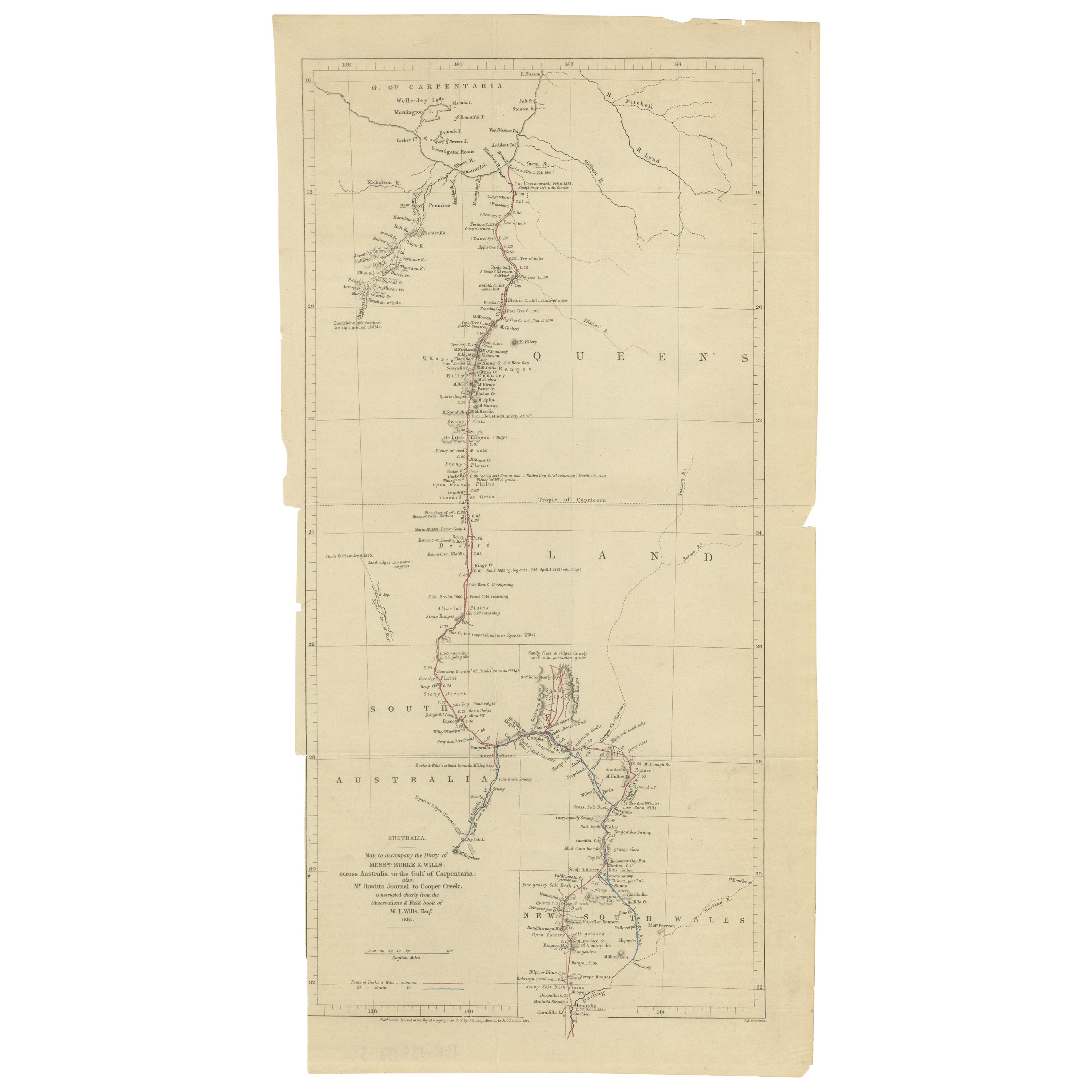
The Fateful Track of The Burke and Wills Expedition in Australia
s Outback, 1862
Located in Langweer, NL
The map depicts the route of the Burke and Wills expedition, one of the most famous and tragic explorations in Australian history. This journey was the first to cross the Australian ...
Category
Antique 1860s Prints
Materials
Paper
$258 Sale Price
20% Off
Free Shipping
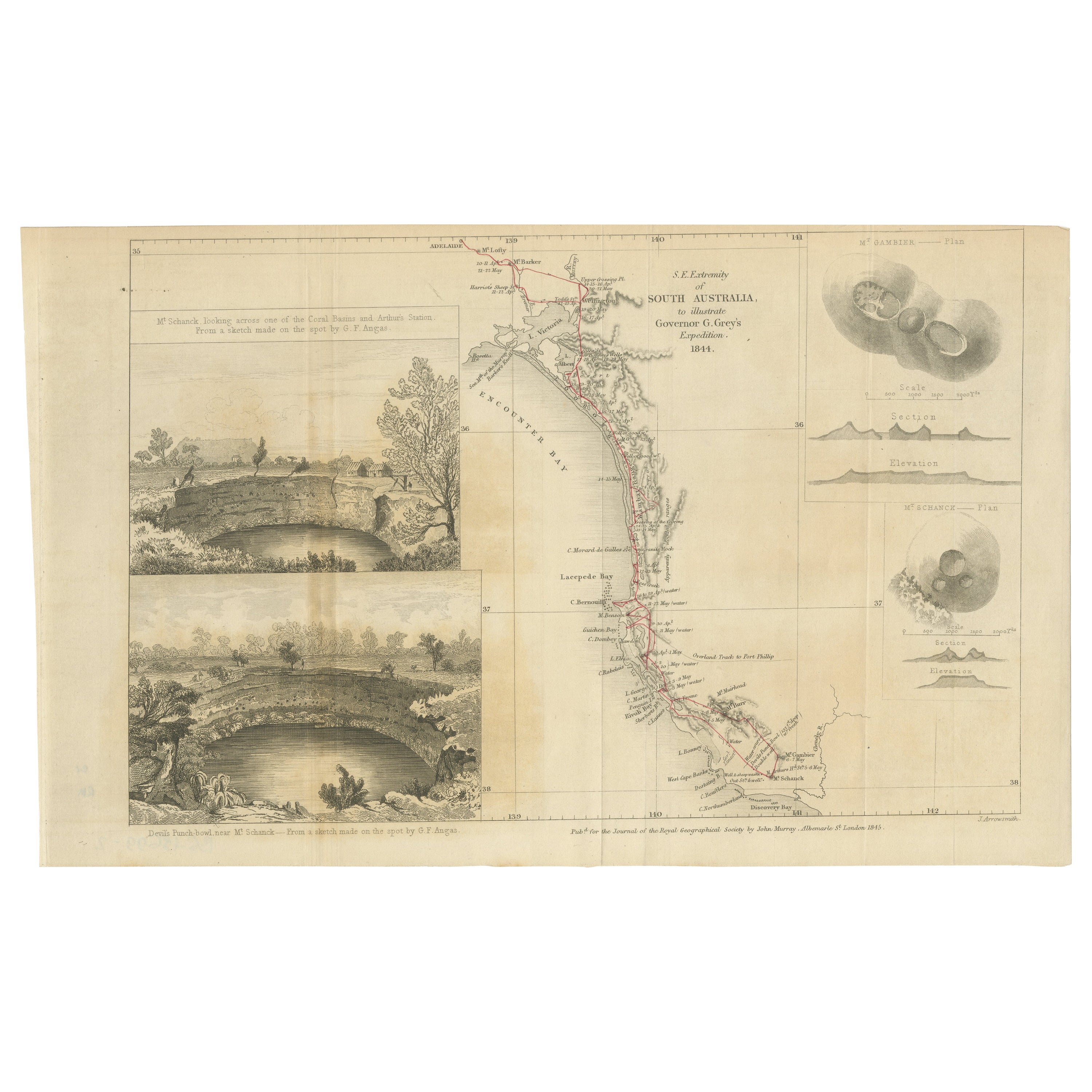
Traversing the Volcanic Frontier: A South Australian Expedition of 1844
Located in Langweer, NL
This is a historical document and part of a map and illustration from an expedition. The text indicates it is from South Australia to illustrate Governor G. Grey's Expedition in 1841...
Category
Antique 1840s Prints
Materials
Paper
$258 Sale Price
20% Off
Free Shipping
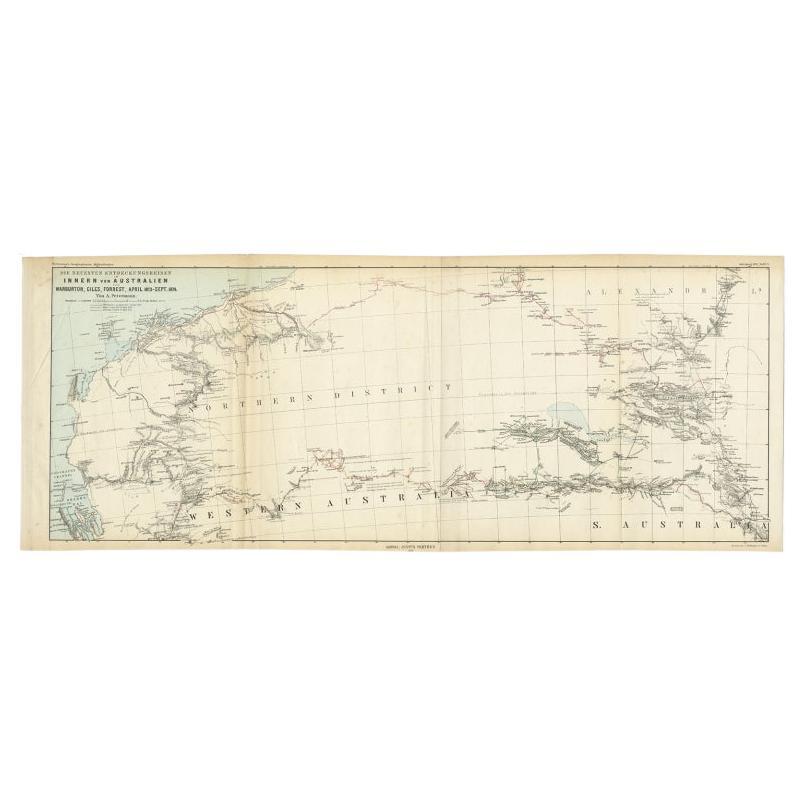
Antique Exploration Map of Australia from Sharks Bay to Alice Springs, 1876
Located in Langweer, NL
Antique map titled 'Die neuesten Entdeckungsreisen Innern von Australien von Warburton, Giles, Forrest (..)'. Old map of Australia from Sharks Bay to 90 Mile Beach over to Alice Springs...
Category
Antique 19th Century Maps
Materials
Paper
Old Map of Cook
s Discovery and Charting of the East Coast of Australia, 1803
Located in Langweer, NL
Antique map titled 'Kaart van Nieuw Zuid Wales of de Oostlyke Kust van Nieuw Holland ontdekt en onderzogt door den Luitenant J. Cook met het Schip de Endeavour in het Jaar 1770'.
...
Category
Antique Early 1800s Maps
Materials
Paper

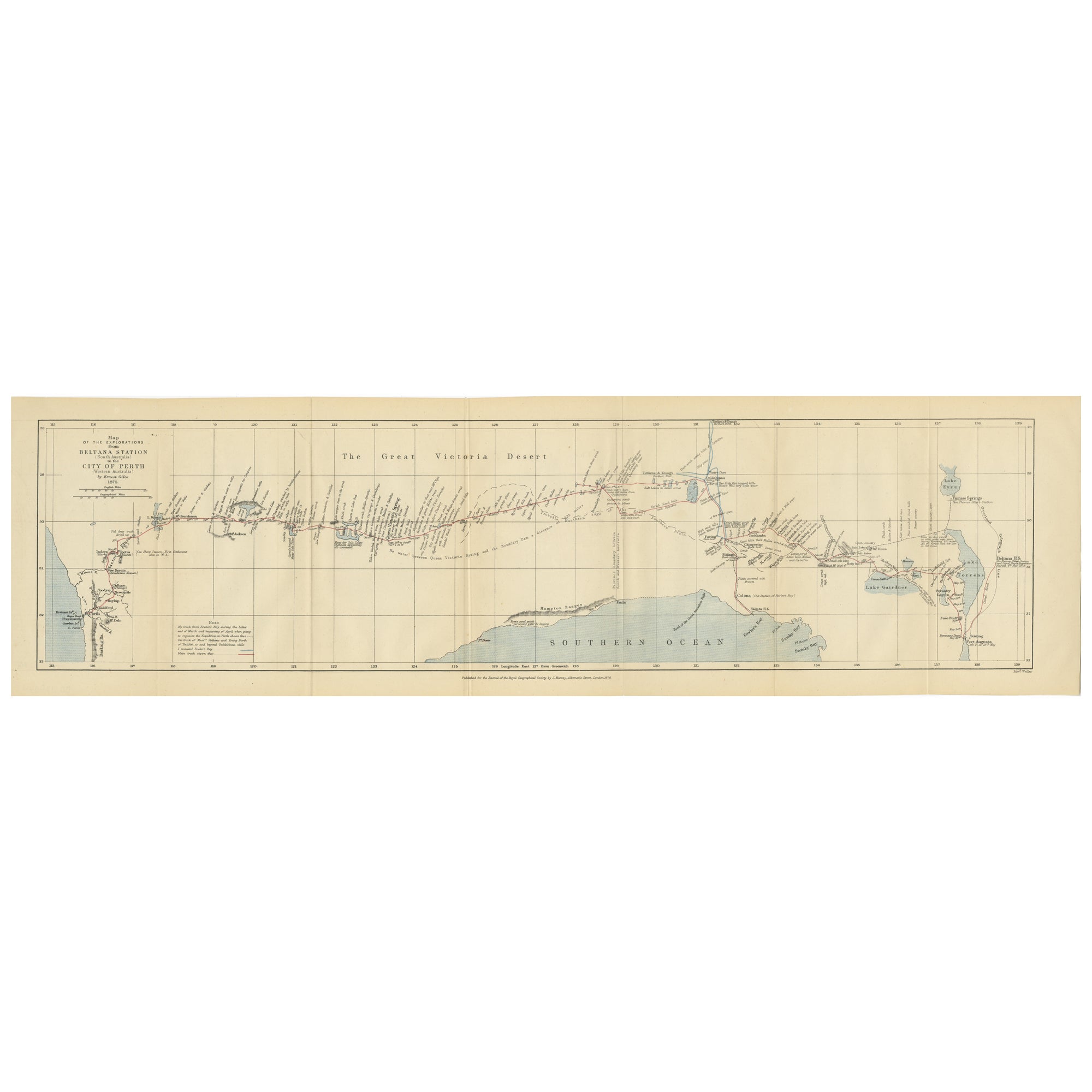
The 4000km Exploration of Ernest Giles from Beltena to Perth, Australia in 1875
Located in Langweer, NL
The map shows the route of the 1875 exploration led by Ernest Giles from Beltana Station in South Australia to the city of Perth in Western Australia. This was Giles' fourth and most...
Category
Antique 1870s Prints
Materials
Paper
You May Also Like
Original Antique Map of Australia by Dower, circa 1835
Located in St Annes, Lancashire
Nice map of Australia
Drawn and engraved by J.Dower
Published by Orr & Smith. C.1835
Unframed.
Free shipping
Category
Antique 1830s English Maps
Materials
Paper

Large U.S. Coast and Geodetic Survey Chart A of the Atlantic Coast, 1877
Located in Nantucket, MA
Large U.S. Coast and Geodetic Survey Chart A of the Atlantic Coast, 1877, re-issued in February 1881, a printed paper laid down on linen navigational chart of the U.S. Atlantic coast...
Category
Antique 1880s American Other Maps
Materials
Linen

Large Original Antique Map of Australia by Sidney Hall, 1847
Located in St Annes, Lancashire
Great map of Australia
Drawn and engraved by Sidney Hall
Steel engraving
Original colour outline
Published by A & C Black. 1847
Unframed
Free shipping.
Category
Antique 1840s Scottish Maps
Materials
Paper

Australia, Tallis antique map, 1851
Located in Melbourne, Victoria
'Australia'
With decorative border surrounds and vignettes including a view of Sydney, Kangaroos, Natives of Australia Felix, Australian Parrots and Cockatoos and Natives of the Tri...
Category
19th Century Naturalistic Landscape Prints
Materials
Engraving

Antique Maritime Chart of East Coast Virginia to Nova Scotia
Located in Norwell, MA
1920 nautical chart of the East Coast of the United States from Virginia to Maine, New Brunswick, and Nova Scotia. The chart shows Cape Cod, Long Island, the Connecticut coast, Jersey Shore, Maine, New Hampshire, etc. Very detailed, showing ports, lighthouses, shoals, depths, etc. The chart is by famous cartographer George W. Eldridge, compiled from surveys of the United States government, British Admiralty, George Eldridge, and others. First authorized by George Eldridge, published in 1916 by Wilfred O. White with a merchant's stamp of Charles Hutchinson...
Category
Vintage 1920s North American Maps
Materials
Paper

Ancient National Atlas of France with Marengo
Located in Alessandria, Piemonte
Ancient National Atlas of France with the department of Marengo: a rare French etching dated 1806.
ST/178.
Category
Antique Early 19th Century French Other Prints
Materials
Paper

More Ways To Browse
Antique Smoking Set
Antique Solingen
Antique Stable Door
Antique Staffordshire Cows
Antique Stirrup Cup
Antique Teapoy
Antique Tool Chest
Antique Wedgwood Dishes
Antique Wood Beams
Arabia Finland Kaj Franck
Arabic Plates
Art Deco Automobile
Art Deco Lizard
Art Nouveau Horn
Arte Vetraria Muranese (AVEM) On Sale
Ashford Marble
Ashley Wood
Asian Coins