Want more images or videos?
Request additional images or videos from the seller
1 of 8
Auction endedBrowse Current Auctions
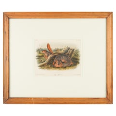
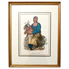
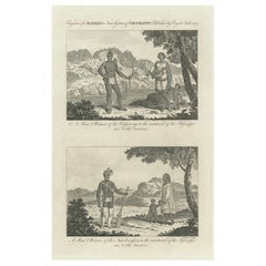
A Chippeway Family to the Eastward of The Mississippi in North America, 1788
Price:$122.24
$215.99List Price
About the Item
- Dimensions:Height: 6.7 in (17 cm)Width: 9.45 in (24 cm)Depth: 0 in (0.02 mm)
- Materials and Techniques:Paper,Engraved
- Period:1780-1789
- Date of Manufacture:1788
- Condition:Good. Chip of top corner is missing, but image and text are complete. One crease in the top, touching the text, otherwise fine. Study the images carefully.
- Seller Location:Langweer, NL
- Reference Number:Seller: BG-13600-51stDibs: LU3054338387472
About the Seller
5.0
Recognized Seller
These prestigious sellers are industry leaders and represent the highest echelon for item quality and design.
Platinum Seller
Premium sellers with a 4.7+ rating and 24-hour response times
Established in 2009
1stDibs seller since 2017
2,819 sales on 1stDibs
Typical response time: 1 hour
Authenticity Guarantee
In the unlikely event there’s an issue with an item’s authenticity, contact us within 1 year for a full refund. DetailsMoney-Back Guarantee
If your item is not as described, is damaged in transit, or does not arrive, contact us within 7 days for a full refund. Details24-Hour Cancellation
You have a 24-hour grace period in which to reconsider your purchase, with no questions asked.Vetted Professional Sellers
Our world-class sellers must adhere to strict standards for service and quality, maintaining the integrity of our listings.Price-Match Guarantee
If you find that a seller listed the same item for a lower price elsewhere, we’ll match it.Trusted Global Delivery
Our best-in-class carrier network provides specialized shipping options worldwide, including custom delivery.You May Also Like
New Map of North America from the Latest Discoveries, 1763
Located in Philadelphia, PA
A fine antique 18th century map of the North American seaboard.
Entitled "A New Map of North America from the Latest Discoveries 1763".
By the Cartographer/Engraver - John Spil...
Category
Antique Mid-18th Century English Georgian Maps
Materials
Paper

Jay
s Squirrel from the “Quadrupeds of North America" by J.J. Audubon, 1848
By John James Audubon
Located in Kenilworth, IL
Jay's Squirrel from the Audubon quarto edition of “Quadrupeds of North America”. The print has been archival mounted and framed in a period molding.
Top left: No. 18
Top right: Plat...
Category
Antique Mid-19th Century American Prints
Materials
Paper
$275
H 15.75 in W 18.75 in D 0.75 in
Pair of prints from “The Ferns of North America" by Daniel Cady Eaton, 1879
Located in Kenilworth, IL
Pair of American botanical chromolithographic prints from “The Ferns of North America” by Daniel Cady Eaton, published by S.E. Cassino. Mounted on eight ply archival mat and framed i...
Category
Antique 1870s American Prints
Materials
Paper
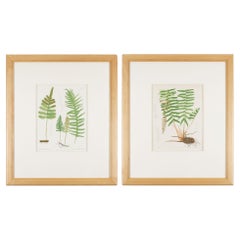
$750 / set
H 23.25 in W 19.75 in D 0.75 in
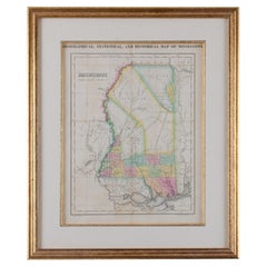
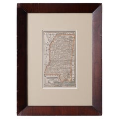
Map of Mississippi Carey
Lea, 1822
Located in Savannah, GA
Published in Philadelphia for the “Complete Historical, Chronological and Geographical American Atlas” by Henry Carey and Issac Lea, the map depicts Mississippi as it existed in 1822...
Category
Antique 1820s American Other Prints
Materials
Glass, Wood, Paper
McKenney
Hall, Hand Colored Lithos Indian Tribes Of North America
Located in Bridgeport, CT
A hand-colored lithograph from Indian Tribes of North America by Thomas McKenney (1785-1859) and James Hall (1793-1868) titled Naw-Kaw or Wood, A Winnebago Chief. The lithograph by L...
Category
Antique 19th Century American Native American Prints
Materials
Glass, Wood, Paper
$3,200 / set
H 26.75 in W 22.75 in D 1 in
Map of Mississippi from Fanning
s Illustrated Gazetteer, 1853
Located in Savannah, GA
A map of Mississippi from Fanning’s Illustrated Gazetteer, 1853.
sight: 5 by 8 ½ inches
frame: 12 ½ by 16 ½ inches
Category
Antique 1850s American Prints
Materials
Glass, Wood, Paper
Vintage Map Wall Chart Countries of North America Rollable Mural Poster
Located in Berghuelen, DE
The vintage pull-down school map illustrates the countries / states of North America. Published by Haack-Painke Justus Perthes Darmstadt. Colorful print on paper reinforced with canv...
Category
Late 20th Century German Country Prints
Materials
Canvas, Wood, Paper
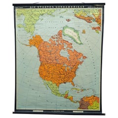
$380
H 51.19 in W 39.38 in D 0.79 in
McKenney and Hall Hand-Painted Lithograph "Chippeway Widow", circa 1837
By McKenney
Hall
Located in Incline Village, NV
"Chippeway Widow" hand-painted color lithograph on paper depicts a Native American Indian woman lamenting the death of her husband, presum...
Category
Antique 1830s Native American Prints
Materials
Paper
$1,475
H 23.75 in W 19 in D 1 in
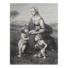
Large Original Antique Print of the Holy Family, circa 1900
Located in St Annes, Lancashire
Wonderful image of The Holy Family
Chromolithograph
Published, circa 1900
Unframed.
Category
Antique Early 1900s English Renaissance Revival Prints
Materials
Paper

$45
Free Shipping
H 19.5 in W 14 in D 0.07 in
Original Antique Print of The Holy Family After Raphael. C.1850
Located in St Annes, Lancashire
Great image after Raphael
Fine steel engraving
Published circa 1850
Unframed.
Free shipping
Category
Antique 1850s English Renaissance Prints
Materials
Paper
$35
Free Shipping
H 10.75 in W 8 in D 0.07 in
More From This Seller
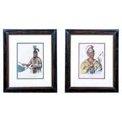
View AllEngraved Representations of North American Tribes around the Mississippi, 1787
Located in Langweer, NL
The original antique print is a pair of original engravings from "Bankes's New System of Geography." This work, as indicated by the title, was published by royal authority, suggestin...
Category
Antique 1780s Prints
Materials
Paper
$431 Sale Price
20% Off
Free Shipping
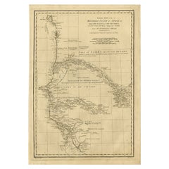
Map of the West African coast from the North of Mauretania to Guinee, 1788
Located in Langweer, NL
Antique map titled 'Particular Map of the Western Coast of Africa, from Cape Blanco to Cape de Verga, and of the Course of the Rivers Senega and Gambia.'
Map of the African coast...
Category
Antique 1780s English Maps
Materials
Paper
$364 Sale Price
20% Off
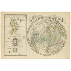
Antique Map of the North Pole
Sangihe Archipelago by Keizer
de Lat, 1788
Located in Langweer, NL
Antique map titled 'De Noord Pool waar in aangetoont werd alle de Nieuwe Landen (..) - De Eilanden van Sangir Sjauw en Pangasare (..)'. Interesting map that includes a map of the Nor...
Category
Antique Late 18th Century Maps
Materials
Paper
$479 Sale Price
20% Off
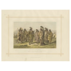
Antique Lithograph of the Aborigines of North America, 1882
Located in Langweer, NL
Experience a captivating glimpse into the world of 19th-century ethnography with the "Aborigines of North America", an antique print from Blackie's Comprehensive Atlas and Geography,...
Category
Antique 1880s British Prints
Materials
Paper
Map of the African Coast, Gulf of Guinea, from Sierra Leone to Gabon, 1788
Located in Langweer, NL
Antique map titled 'Drawn from d'Anvilles Map of the Coast of Guinea, Between Sierra Leone and the crossing of the Line.'
Map of the African coast, Gulf of Guinea, from Sierra Le...
Category
Antique 1780s English Maps
Materials
Paper
$441 Sale Price
20% Off
Antique Map of the West Coast of North America
North East Coast of Asia
1772
Located in Langweer, NL
Antique map titled 'Carte des nouvelles decouvertes/ Extrait d'une Carte Japonoise de l'Universe'. Map of the West Coast of North America and North-East Coast of Asia, based upon Buache's report of the various Russian Discoveries between 1731 and 1742 including the various explorers routes and notes. The lower map is based upon a Japanese map...
Category
Antique Late 18th Century Maps
Materials
Paper

$623 Sale Price
20% Off
Still Thinking About These?
All Recently ViewedMore Ways To Browse
Antique Smoking Set
Antique Solingen
Antique Stable Door
Antique Staffordshire Cows
Antique Stirrup Cup
Antique Teapoy
Antique Tool Chest
Antique Wedgwood Dishes
Antique Wood Beams
Arabia Finland Kaj Franck
Arabic Plates
Art Deco Automobile
Art Deco Lizard
Art Nouveau Horn
Arte Vetraria Muranese (AVEM) On Sale
Ashford Marble
Ashley Wood
Asian Coins