Items Similar to Dardanelles Strait, Ottoman Turkey – Probst Optical View with Ships, c.1770

Want more images or videos?
Request additional images or videos from the seller
1 of 10
Dardanelles Strait, Ottoman Turkey – Probst Optical View with Ships, c.1770
$1,063.26
£794.63
€890
CA$1,466.82
A$1,606.62
CHF 845.89
MX$19,174.52
NOK 10,780.08
SEK 9,854.62
DKK 6,783.71
About the Item
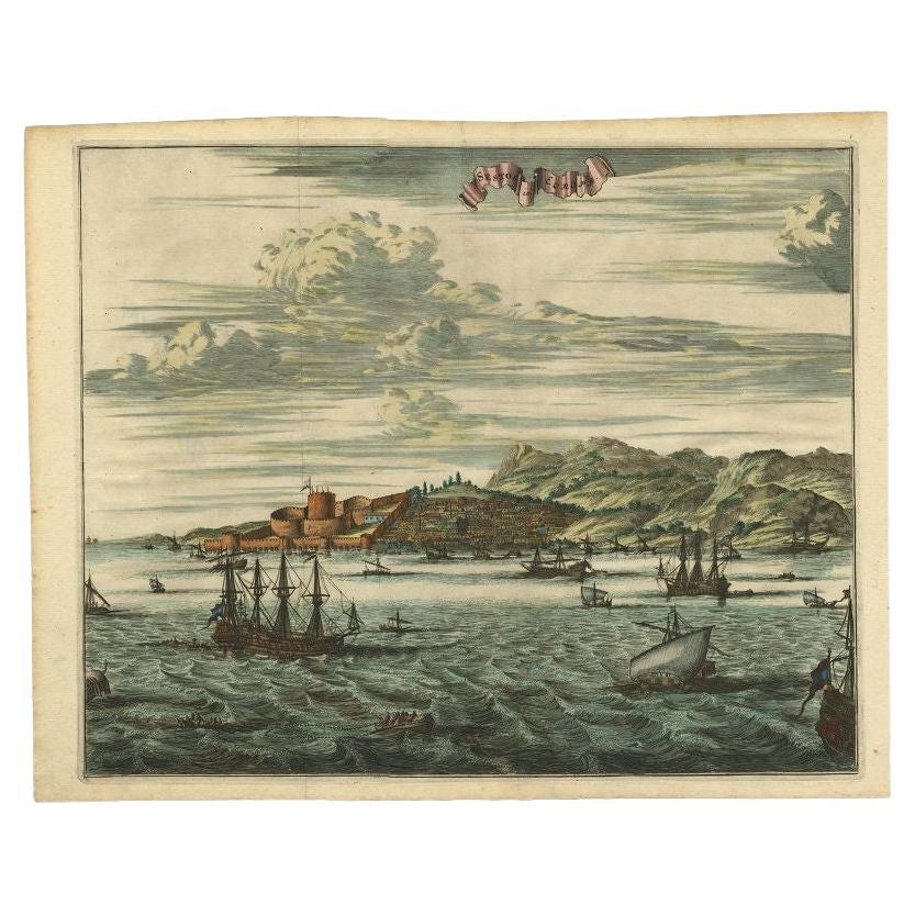
Dardanelles Strait, Ottoman Turkey – Probst Optical View with Ships, c.1770
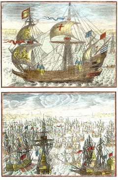
This highly decorative hand-colored optical view depicts the Strait of the Dardanelles (Çanakkale Boğazı), one of the most strategically significant maritime passages between Europe and Asia. Titled Freti Dardanellorum prospectus, the scene presents a sweeping perspective of the narrow waterway connecting the Aegean Sea to the Sea of Marmara, long controlled by the Ottoman Empire and closely monitored by European naval powers.
The composition is animated by numerous sailing vessels—large warships and merchantmen alike—flying Dutch and other European flags as they navigate the winding channel. These ships emphasize both the commercial importance and the geopolitical sensitivity of the Dardanelles during the 18th century, when passage through the strait was subject to strict Ottoman regulation. Fortified castles and towers rise prominently on both shores, illustrating the defensive architecture designed to control maritime traffic and protect Constantinople.
The view is rendered in the characteristic manner of Augsburg optical prints, intended to be viewed through a zograscope or perspective box. The exaggerated depth, receding shoreline, and strong foreground elements heighten the illusion of space and movement, making this print particularly engaging when displayed. The scene is finely hand-colored in period tones, with greens and browns for the hilly landscape, soft blues for sea and sky, and warm ochres and golds accenting the ships.
The print was published in Augsburg around 1770 by Georg Balthasar Probst, one of the most important producers of optical views in the 18th century. Probst’s views were widely distributed across Europe and prized for their visual impact and educational value. The multilingual captions—in Latin, French, Italian, and German—reflect the international audience for which these prints were intended.
As both a decorative work and a historical document, this view appeals to collectors of maritime art, Ottoman and Turkish history, Grand Tour imagery, and early visual culture. Its lively naval scene and strong graphic presence make it especially suitable for framing and display, either as a standalone statement piece or as part of a group of optical or Mediterranean views.
Condition report:
A few small wormholes, as noted, not affecting the main image; otherwise in good condition with clear impression and strong contemporary hand-coloring. Plate mark visible.
Framing tips:
This optical view works beautifully in a classic gilt or dark walnut frame, paired with a neutral or pale blue mat to echo the maritime subject. Museum glass is recommended to protect the original hand-coloring while enhancing clarity.
Technique: Engraving, hand-colored
Maker: Georg Balthasar Probst, Augsburg, c.1770
- Dimensions:Height: 13.78 in (35 cm)Width: 20.08 in (51 cm)Depth: 0.01 in (0.2 mm)
- Materials and Techniques:Paper,Engraved
- Place of Origin:
- Period:1770-1779
- Date of Manufacture:circa 1770
- Condition:A few small wormholes, as noted, not affecting the main image; otherwise in good condition with clear impression and strong contemporary hand-coloring. Plate mark visible.
- Seller Location:Langweer, NL
- Reference Number:Seller: BG-141671stDibs: LU3054347999582
About the Seller
5.0
Recognized Seller
These prestigious sellers are industry leaders and represent the highest echelon for item quality and design.
Platinum Seller
Premium sellers with a 4.7+ rating and 24-hour response times
Established in 2009
1stDibs seller since 2017
2,806 sales on 1stDibs
Typical response time: 1 hour
- ShippingRetrieving quote...Shipping from: Langweer, Netherlands
- Return Policy
More From This Seller
View AllThe Dardanelles in the Age of Sail: A Panoramic Etching, Ca.1765
Located in Langweer, NL
This rare and exquisite view depicts the strategic Dardanelles strait, the narrow passage between the Aegean and the Sea of Marmara with the distant cityscape of Istanbul. Part of th...
Category
Antique 1760s Prints
Materials
Paper

$1,146 Sale Price
20% Off
Free Shipping
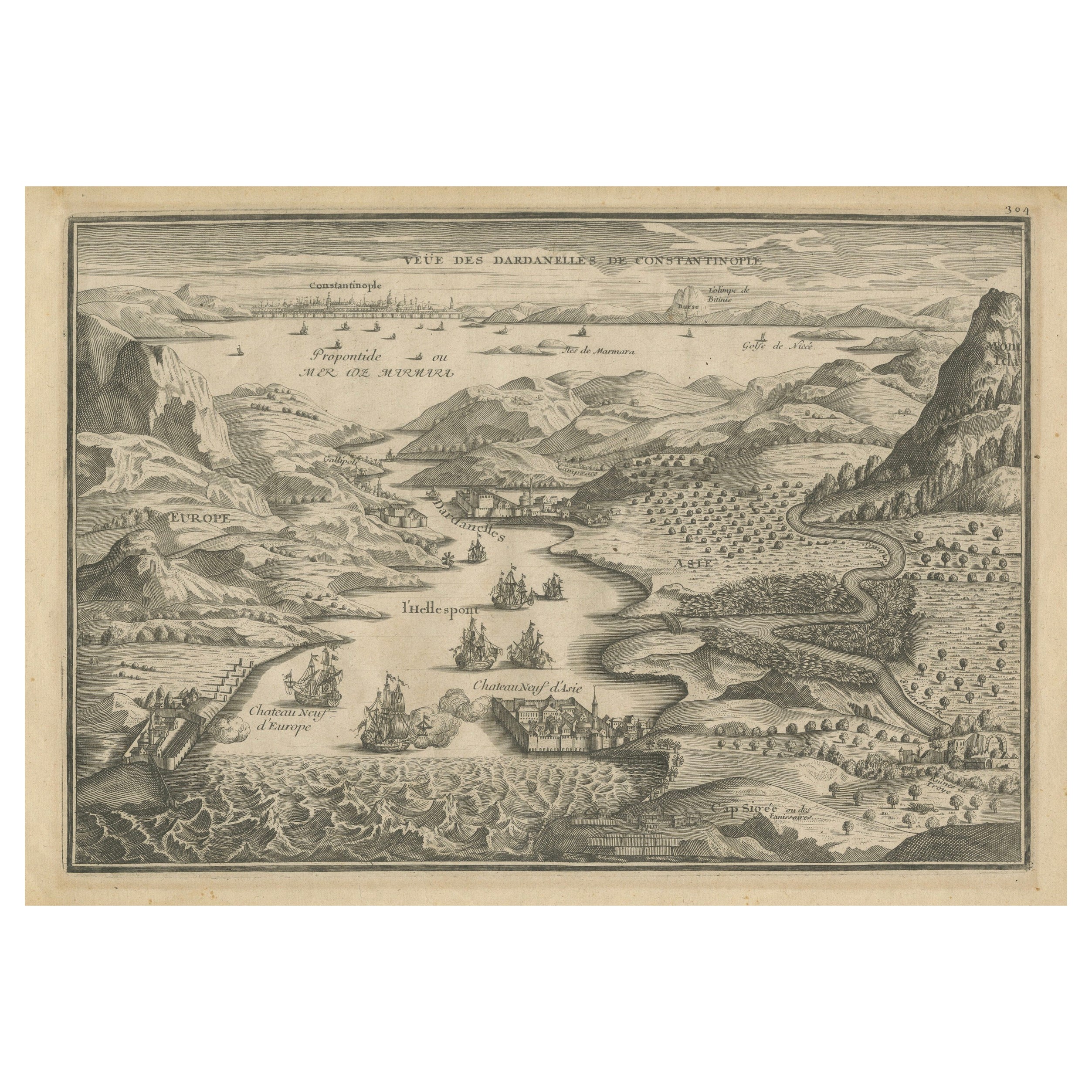
Dardanelles Strait, with a Perspective of the City of Constantinople, 1693
Located in Langweer, NL
Title: "Veue des Dardanelles de Constantinople, 1693"
Description: This historical copper engraving, crafted by Nicholas de Fer between 1646 and 1720 in Paris, is a remarkable depic...
Category
Antique 1690s Prints
Materials
Paper

$324 Sale Price
20% Off
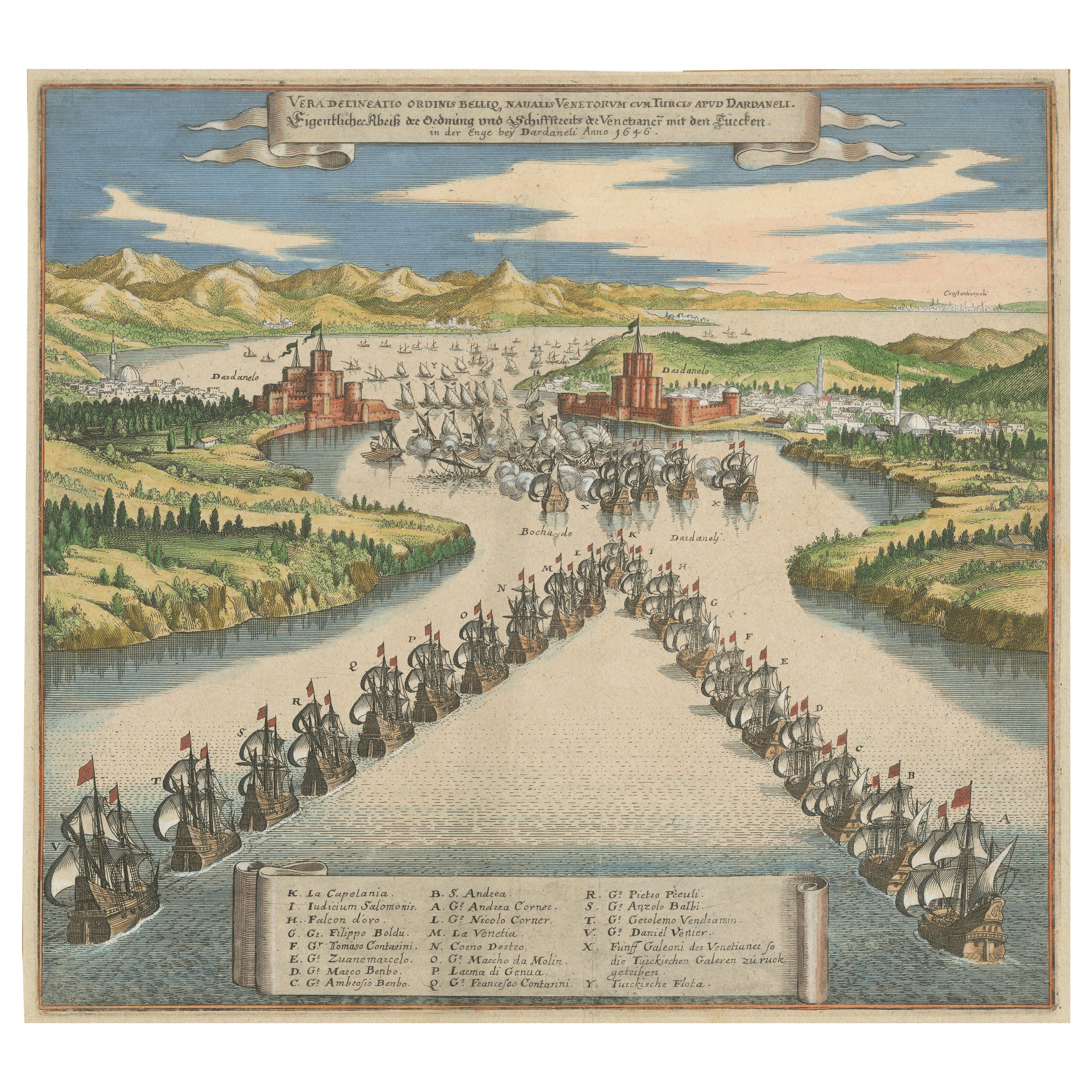
Venetian Fleet vs. Ottoman Turks – Dardanelles Naval Battle Engraving, 1656
Located in Langweer, NL
Venetian Fleet vs. Ottoman Turks – Dardanelles Naval Battle Engraving, 1656
This print was almost certainly published by Matthäus Merian’s heirs, most likely as part of the Theatru...
Category
Antique Mid-17th Century German Prints
Materials
Paper
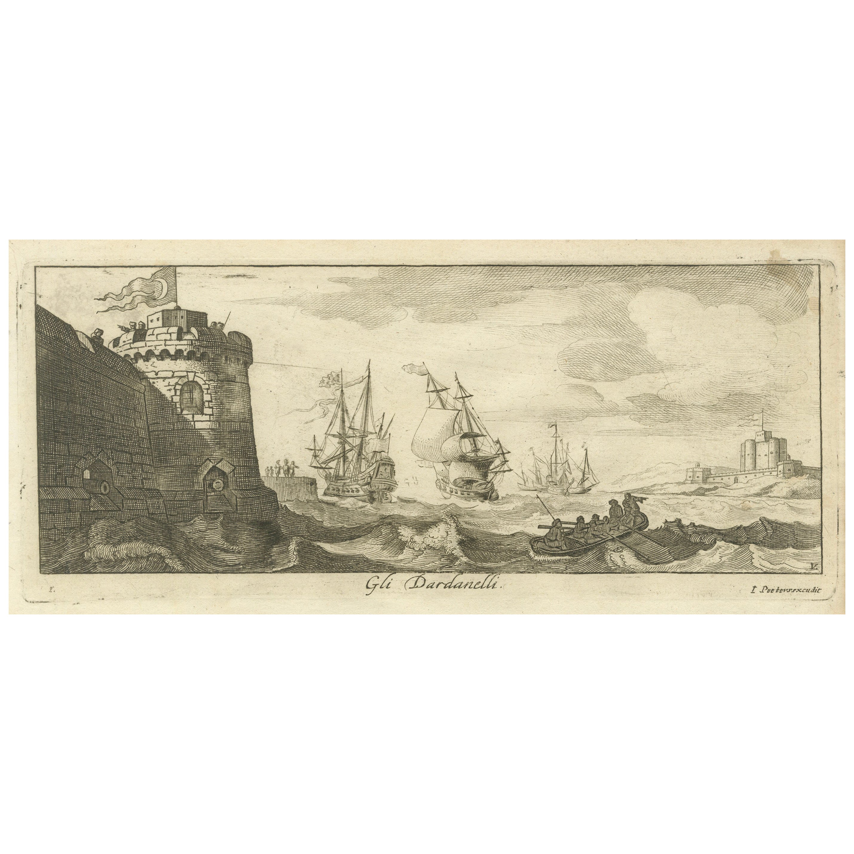
Engraved View of the Dardanelles with Fortifications and Ships, ca. 1680
Located in Langweer, NL
Title: View of the Dardanelles with Fortifications and Ships, ca. 1680
Description: This copperplate engraving offers a detailed view of the Dardanelles Strait, emphasizing its s...
Category
Antique 1680s Prints
Materials
Paper

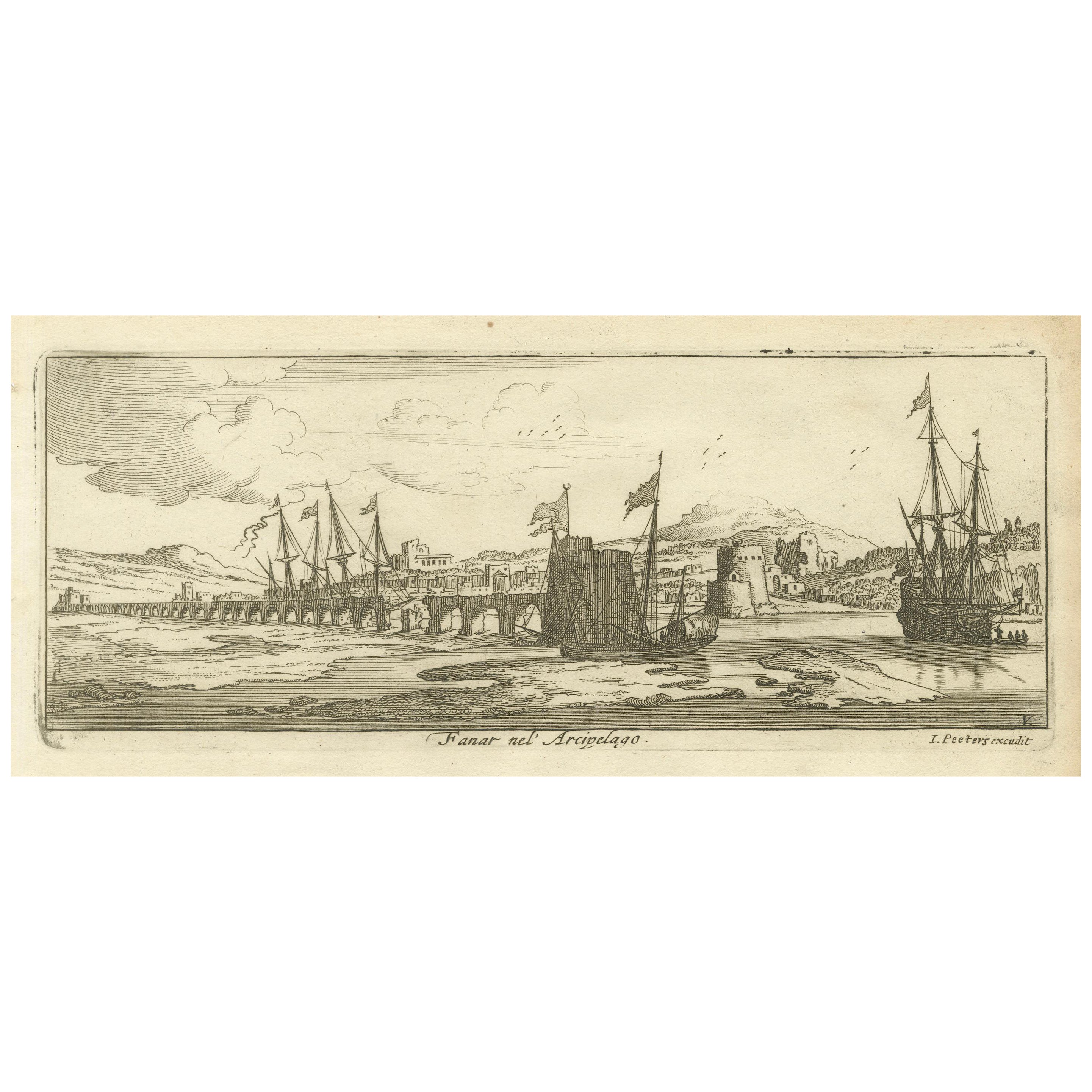
View of Fanar in the Aegean Archipelago with Bridge and Ships, ca. 1680
Located in Langweer, NL
Title: View of Fanar in the Aegean Archipelago with Bridge and Ships, ca. 1680
Description: This copperplate engraving showcases a detailed view of Fanar (possibly Fener or anothe...
Category
Antique 1680s Prints
Materials
Paper
Antique Print of Sestos in Turkey with Ships , circa 1680
Located in Langweer, NL
Antique print titled 'Sestos in Europa'. Original antique print showing a view of Sestos, Turkey with ships. This print originates from 'Naukeurige Beschryving der Eilanden in de Arc...
Category
Antique 17th Century Prints
Materials
Paper
You May Also Like
18th Century French Map and City View of Joppe/Jaffa (Tel Aviv) by Sanson
By Nicholas Sanson d
Abbeville
Located in Alamo, CA
An original antique engraving entitled "Joppe; in ’t Hebreeusch by ouds Japho; hedendaags Japha, of Jaffa; volgens d’aftekening gedaan 1668", by Nicholas Sanson d'Abbeville (1600 - 1667). This is a view of the city of Joppe (in Hebrew Japho), now called Japha or Jaffa, the harbor portion of modern day Tel Aviv, Israel as it appeared in 1668 . It depicts a very busy harbor with numerous boats. A large ship on the left appears to be firing its canons and a small ship on the right appears to be sitting very low in the water, either heavily loaded with cargo or sinking. The town is seen on the far shore with a fortress on a hill across in the background. The map is printed from the original Sanson copperplate and was published in 1709 by his descendants.
The map is presented in an ornate brown wood frame embellished by gold-colored leaves and gold inner trim with a double mat; the outer mat is cream-colored and the inner mat is black. There is a central vertical fold, as issued. There are two small spots in the lower margin and one in the upper margin, as well as two tiny spots adjacent to the central fold. 1717 is written below the date 1668 in the inscription. The map is otherwise in very good condition.
Another map of the "Holy Land" (by Claes Visscher in 1663), with an identical style frame and mat is available. This pair of maps would make a wonderful display grouping. Please see Reference #LU117324709892.
Artist: Nicholas Sanson d'Abbeville (1600 - 1667) and his descendents were important French cartographer's active through the 17th century. Sanson started his career as a historian and initially utilized cartography to illustrate his historical treatises. His maps came to the attention of Cardinal Richelieu and then King Louis XIII of France, who became a supporter and sponsor. He subsequently appointed Sanson 'Geographe Ordinaire du Roi' the official map maker to the king. Sanson not only created maps for the king, but advised him on geographical issues and curated his map collection...
Category
Early 1700s Prints and Multiples
Materials
Engraving

Antique Voc Print Holland Malaysia Old Map Melaka History, 1663
Located in Amsterdam, Noord Holland
From my own collection I offer this impressive Antique print of the city of Malakka
A very interesting piece for collectors . It is an museum piece from the Dutch Institute of Orien...
Category
Antique 17th Century European Paintings
Materials
Paper

$293 Sale Price
20% Off
Two naval images depicting 17th century warships
Located in Middletown, NY
French School 20th century
Two naval images depicting 17th century warships flying various flags, including the Plantagenet Lions and St. George's Cross. (2)
c1950. Two engravings w...
Category
20th Century French School Still-life Prints
Materials
Watercolor, Engraving
Aden, Map from "Civitates Orbis Terrarum" - by F. Hogenberg - 1575
By Franz Hogenberg
Located in Roma, IT
Braun G., Hogenberg F., Aden, from the collection Civitates Orbis Terrarum, Cologne, T. Graminaeus, 1572-1617.
Good conditions except some stains on margins and a central fold.
The ...
Category
16th Century Figurative Prints
Materials
Etching, Aquatint
Laurie and Whittle - 1794 Engraving, A General View of the City of Lisbon
Located in Corsham, GB
A vibrant and captivating print depicting an expansive view of Lisbon, with ships sailing in the foreground. Inscribed within the plate below the image. On paper.
Category
Early 18th Century Landscape Prints
Materials
Engraving
Cadiz Island: A Framed 17th Century Hand-colored Map from Blaeu
s Atlas Major
By Joan (Johannes) Blaeu
Located in Alamo, CA
This is a 17th century hand-colored map entitled "Insula Gaditana Isla de Cadiz" from Johannes (Joan) Blaeu's Atlas Maior, published in Amsterdam in 1662.
The map provides an excellent plan of Cadiz Island on the southwest coast of Spain, with its harbor, fortifications, agricultural fields and several surrounding salt processing areas. Numerous sailing ships of various sizes are included in and around the harbor and bay, including five large sailing ships, as well as twenty-four smaller ships. There is a small compass rose overlying the bay. The bridge to the mainland from the island is shown on the right. There is an extremely ornate and colorful title cartouche in the lower left, with its mythological figures reminiscent of Raphael’s Galatea fresco at the Villa Farnesina in Rome. The vibrant colors are vividly preserved. The master colorist tried to emulate a painting by using various tones to create a three-dimensional effect.
Blaeu's name is present in the plate in the lower right. Blaeu stated in his description of Cadiz: “The main wealth of the islanders consists of salt, which they harvest, and
the tuna fisheries.”
This 17th century hand-colored map is framed in an ornate, partially textured bronze-colored wood frame and glazed with UV protected conservation glass. There is a vertical center fold, as issued. There is a faint crease in the lower right and faint color offset on the left from the right side of the map, resulting from having been in an atlas for hundreds of years. Small foci of paint are present in the upper portion of the left margin and in the left corner margin. The map is otherwise in very good condition.
Due in large part to their powerful trade empire, the Dutch became known for cartography in the seventeenth century. This period is considered the Golden Age of Dutch cartography. Their publishing houses produced the highest quality work in Europe, particularly those maps and charts of foreign lands, and Dutch map-making set the bar for cartographic accuracy and artistry into the early-eighteenth century. Some of the most well-known cartographers worked in Amsterdam during this period. Perhaps the most famous of these was the Blaeu family. Willem Janszoon Blaeu, set up shop in Amsterdam. His son, Johannes (Joan), succeeded him upon his death in 1638, continuing in his father’s position as Hydrographer to the Dutch East India Company and selling maps to the public. The Blaeu map presses, located near Amsterdam’s Dam Square...
Category
Mid-17th Century Old Masters Landscape Prints
Materials
Engraving
