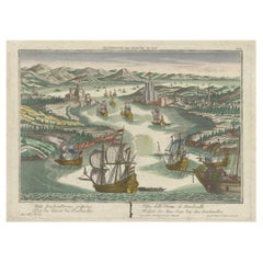
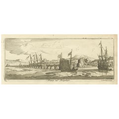
Items Similar to Dardanelles Strait, with a Perspective of the City of Constantinople, 1693

Want more images or videos?
Request additional images or videos from the seller
1 of 7
Dardanelles Strait, with a Perspective of the City of Constantinople, 1693
$324.83
$406.0320% Off
£242.72
£303.4020% Off
€272
€34020% Off
CA$448.05
CA$560.0620% Off
A$490.82
A$613.5320% Off
CHF 258.35
CHF 322.9420% Off
MX$5,858.12
MX$7,322.6520% Off
NOK 3,293.32
NOK 4,116.6520% Off
SEK 3,010.59
SEK 3,763.2420% Off
DKK 2,072.43
DKK 2,590.5320% Off
About the Item
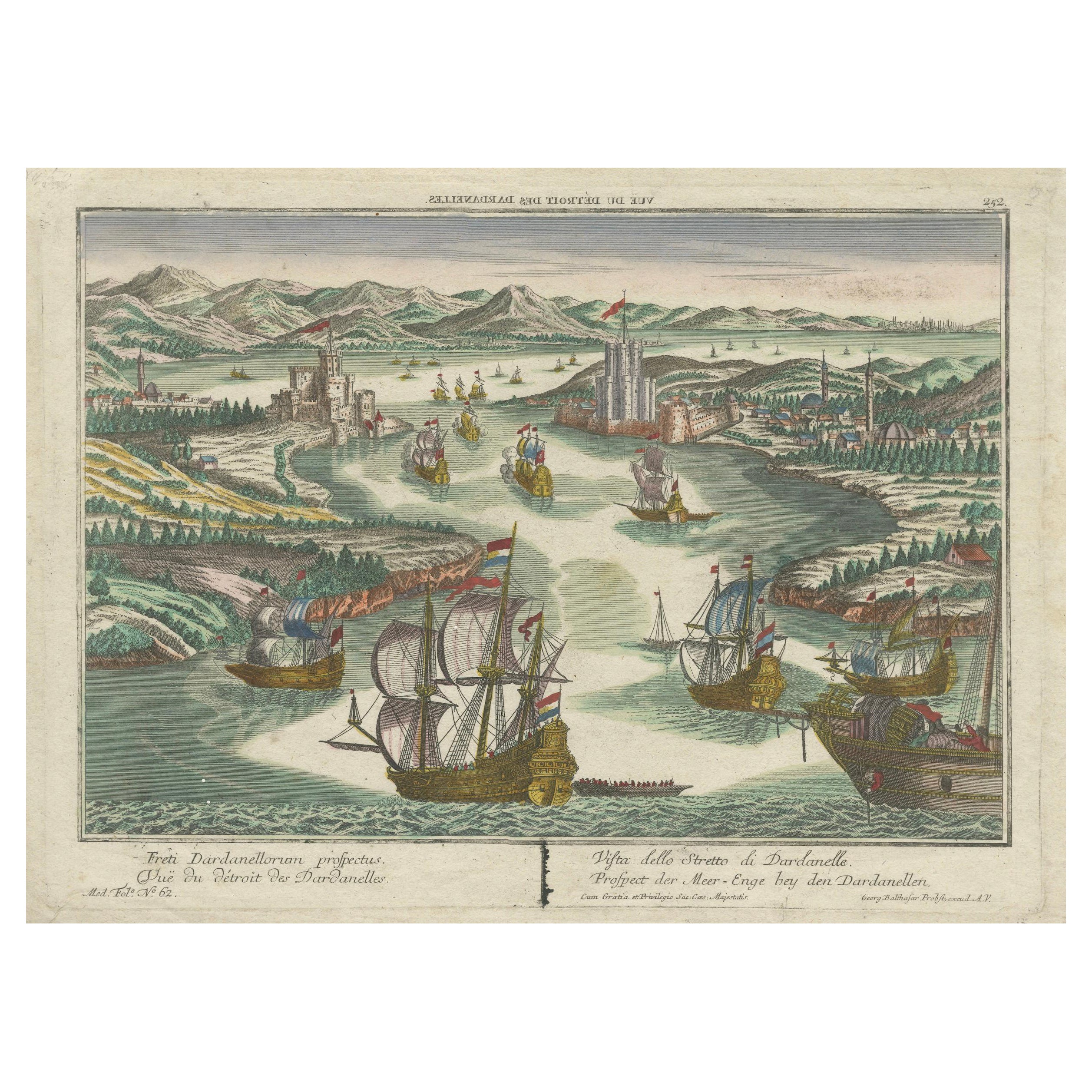
Title: "Veue des Dardanelles de Constantinople, 1693"
Description: This historical copper engraving, crafted by Nicholas de Fer between 1646 and 1720 in Paris, is a remarkable depiction titled "Veue des Dardanelles de Constantinople."
It was included in de Fer's esteemed collection, "Les Forces de l'Europe," published in 1693. The detailed artwork offers a panoramic view of the strategic Dardanelles Strait, with a distant perspective of the city of Constantinople (modern-day Istanbul) in the backdrop.
The engraving not only captures the strategic importance of the Dardanelles, historically known as the Hellespont, but also serves as a valuable cartographic document of the era, showcasing the military and maritime strength of the region during the late 17th century.
- Dimensions:Height: 10.56 in (26.8 cm)Width: 15.75 in (40 cm)Depth: 0 in (0.02 mm)
- Materials and Techniques:Paper,Engraved
- Period:1690-1699
- Date of Manufacture:1693
- Condition:Good. Engraving on hand laid (verge) paper with original watermark. General age-related toning and/or occasional minor defects from handling. Please study scan carefully.
- Seller Location:Langweer, NL
- Reference Number:Seller: BG-137291stDibs: LU3054338822542
About the Seller
5.0
Recognized Seller
These prestigious sellers are industry leaders and represent the highest echelon for item quality and design.
Platinum Seller
Premium sellers with a 4.7+ rating and 24-hour response times
Established in 2009
1stDibs seller since 2017
2,806 sales on 1stDibs
Typical response time: 1 hour
- ShippingRetrieving quote...Shipping from: Langweer, Netherlands
- Return Policy
More From This Seller
View AllDardanelles Strait, Ottoman Turkey – Probst Optical View with Ships, c.1770
Located in Langweer, NL
Dardanelles Strait, Ottoman Turkey – Probst Optical View with Ships, c.1770
This highly decorative hand-colored optical view depicts the Strait of the Dardanelles (Çanakkale Boğazı)...
Category
Antique 1770s German Prints
Materials
Paper
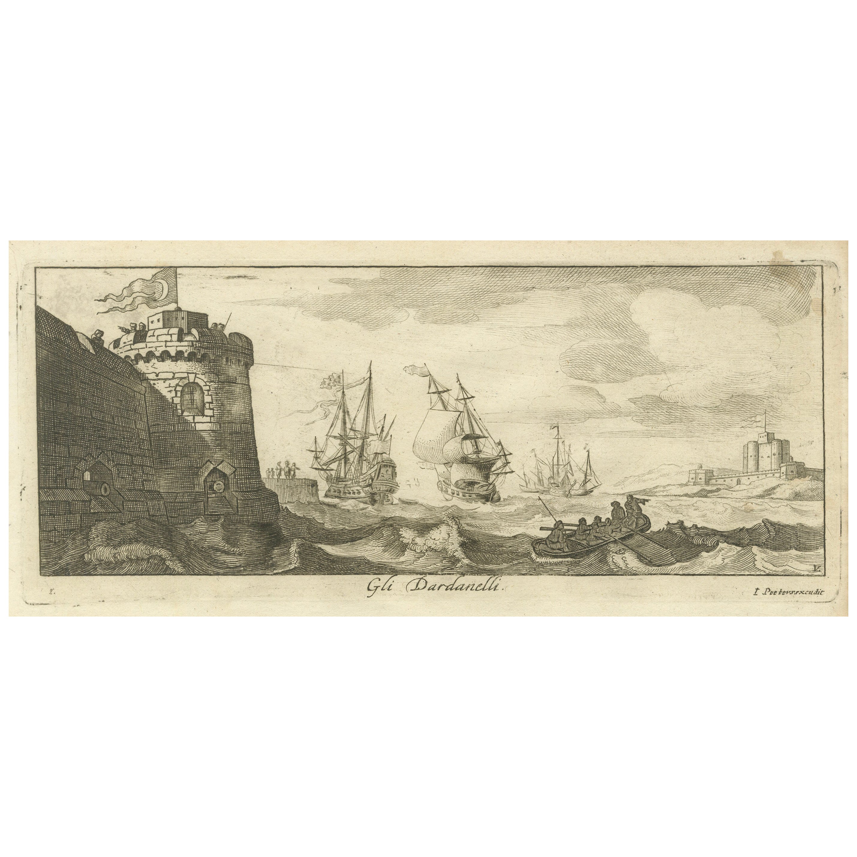
Engraved View of the Dardanelles with Fortifications and Ships, ca. 1680
Located in Langweer, NL
Title: View of the Dardanelles with Fortifications and Ships, ca. 1680
Description: This copperplate engraving offers a detailed view of the Dardanelles Strait, emphasizing its s...
Category
Antique 1680s Prints
Materials
Paper

The Dardanelles in the Age of Sail: A Panoramic Etching, Ca.1765
Located in Langweer, NL
This rare and exquisite view depicts the strategic Dardanelles strait, the narrow passage between the Aegean and the Sea of Marmara with the distant cityscape of Istanbul. Part of th...
Category
Antique 1760s Prints
Materials
Paper

$1,146 Sale Price
20% Off
Free Shipping
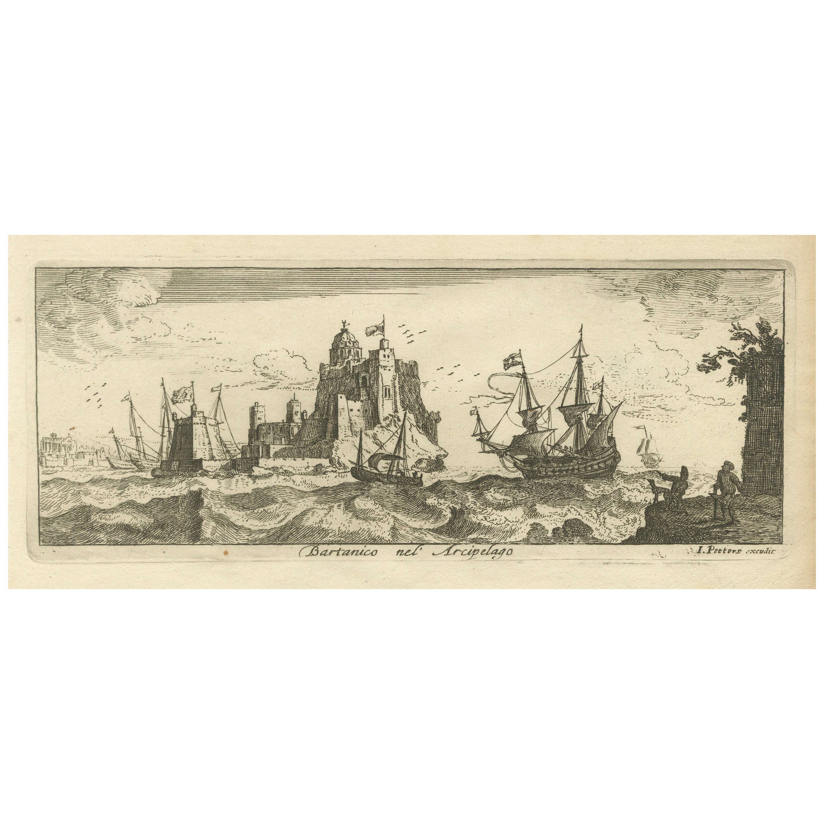
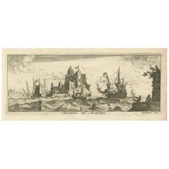
View of Bartanico in the Aegean Archipelago with Fortifications and Ships, 1680
Located in Langweer, NL
Title: View of Bartanico in the Aegean Archipelago with Fortifications and Ships, ca. 1680
Description: This copperplate engraving depicts a striking view of Bartanico (possibly P...
Category
Antique 1680s Prints
Materials
Paper
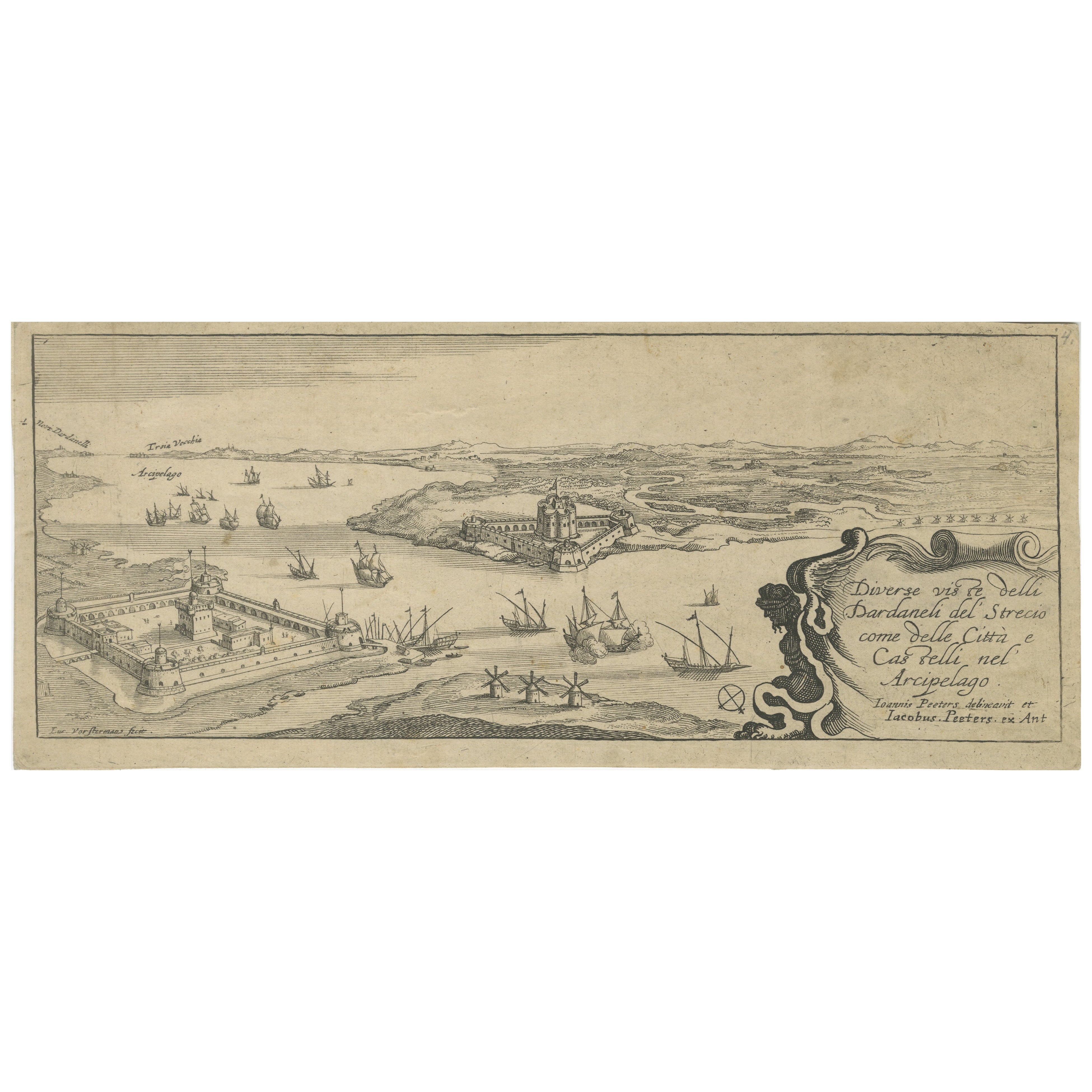
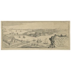
Title page from "Views of the Dardanelles", engraved by Jacob Peeters, ca. 1680
Located in Langweer, NL
Title:
Diverse viste delli Dardanelli del Strecio, come delle Città e Castelli nel Arcipelago – Title page of the series, engraved by Jacob Peeters after Jan Peeters, Antwerp, circ...
Category
Antique 1680s Prints
Materials
Paper
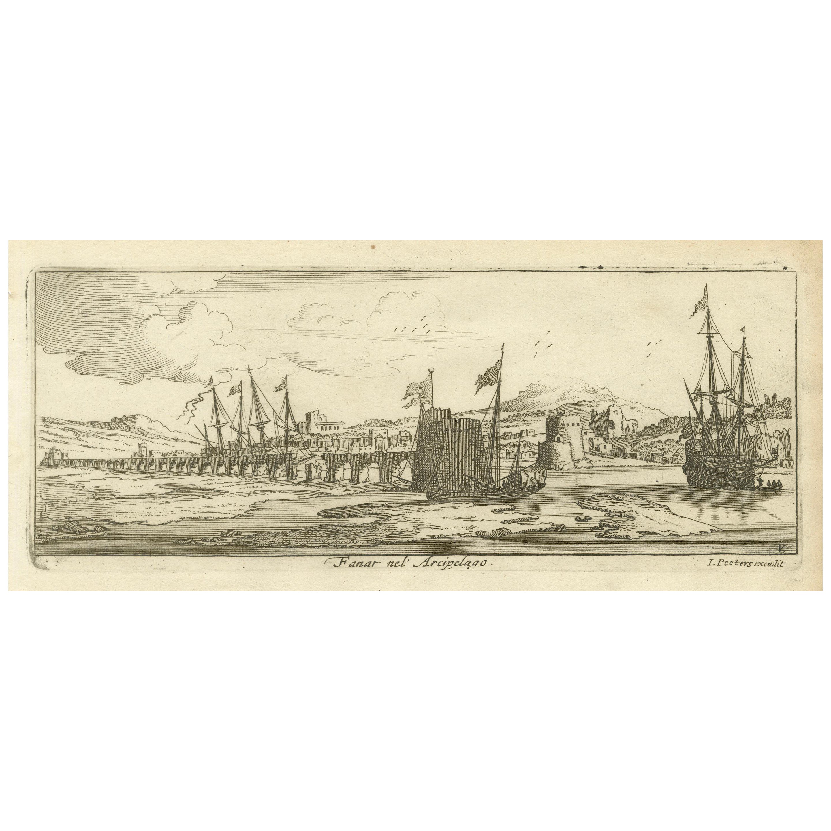
View of Fanar in the Aegean Archipelago with Bridge and Ships, ca. 1680
Located in Langweer, NL
Title: View of Fanar in the Aegean Archipelago with Bridge and Ships, ca. 1680
Description: This copperplate engraving showcases a detailed view of Fanar (possibly Fener or anothe...
Category
Antique 1680s Prints
Materials
Paper
You May Also Like
18th Century French Map and City View of Joppe/Jaffa (Tel Aviv) by Sanson
By Nicholas Sanson d
Abbeville
Located in Alamo, CA
An original antique engraving entitled "Joppe; in ’t Hebreeusch by ouds Japho; hedendaags Japha, of Jaffa; volgens d’aftekening gedaan 1668", by Nicholas Sanson d'Abbeville (1600 - 1667). This is a view of the city of Joppe (in Hebrew Japho), now called Japha or Jaffa, the harbor portion of modern day Tel Aviv, Israel as it appeared in 1668 . It depicts a very busy harbor with numerous boats. A large ship on the left appears to be firing its canons and a small ship on the right appears to be sitting very low in the water, either heavily loaded with cargo or sinking. The town is seen on the far shore with a fortress on a hill across in the background. The map is printed from the original Sanson copperplate and was published in 1709 by his descendants.
The map is presented in an ornate brown wood frame embellished by gold-colored leaves and gold inner trim with a double mat; the outer mat is cream-colored and the inner mat is black. There is a central vertical fold, as issued. There are two small spots in the lower margin and one in the upper margin, as well as two tiny spots adjacent to the central fold. 1717 is written below the date 1668 in the inscription. The map is otherwise in very good condition.
Another map of the "Holy Land" (by Claes Visscher in 1663), with an identical style frame and mat is available. This pair of maps would make a wonderful display grouping. Please see Reference #LU117324709892.
Artist: Nicholas Sanson d'Abbeville (1600 - 1667) and his descendents were important French cartographer's active through the 17th century. Sanson started his career as a historian and initially utilized cartography to illustrate his historical treatises. His maps came to the attention of Cardinal Richelieu and then King Louis XIII of France, who became a supporter and sponsor. He subsequently appointed Sanson 'Geographe Ordinaire du Roi' the official map maker to the king. Sanson not only created maps for the king, but advised him on geographical issues and curated his map collection...
Category
Early 1700s Prints and Multiples
Materials
Engraving

18th Century French Map and City View of Joppe/Jaffa
Tel Aviv
by Sanson
By Nicolas Sanson
Located in Alamo, CA
An original antique engraving entitled "Joppe; in ’t Hebreeusch by ouds Japho; hedendaags Japha, of Jaffa; volgens d’aftekening gedaan 1668", by Nicholas Sanson d'Abbeville (1600 - 1667). This is a view of the city of Joppe (in Hebrew Japho), now called Japha or Jaffa, the harbor portion of modern day Tel Aviv, Israel as it appeared in 1668 . It depicts a very busy harbor with numerous boats. A large ship on the left appears to be firing its canons and a small ship on the right appears to be sitting very low in the water, either heavily loaded with cargo or sinking. The town is seen on the far shore with a fortress on a hill across in the background. The map is printed from the original Sanson copperplate and was published in 1709 by his descendants.
The map is presented in an ornate brown wood frame embellished by gold-colored leaves and gold inner trim with a double mat; the outer mat is cream-colored and the inner mat is black. There is a central vertical fold, as issued. There are two small spots in the lower margin and one in the upper margin, as well as two tiny spots adjacent to the central fold. 1717 is written below the date 1668 in the inscription. The map is otherwise in very good condition.
Another map of the "Holy Land" (by Claes Visscher in 1663), with an identical style frame and mat is available. This pair of maps would make a wonderful display grouping. Please see Reference #LU5206220653552. A discount is available for the purchase of the pair of maps.
Artist: Nicholas Sanson d'Abbeville (1600-1667) and his descendents were important French cartographer's active through the 17th century. Sanson started his career as a historian and initially utilized cartography to illustrate his historical treatises. His maps came to the attention of Cardinal Richelieu and then King Louis XIII of France, who became a supporter and sponsor. He subsequently appointed Sanson 'Geographe Ordinaire du Roi' the official map maker to the king. Sanson not only created maps for the king, but advised him on geographical issues and curated his map collection...
Category
Antique Early 18th Century French Maps
Materials
Paper

Ancient View of the Bosphorus - Original Lithograph - Half of the 19th Century
Located in Roma, IT
Ancient View of the Bosphorus is an original modern artwork realized in the first half of the 19th Century.
Original B/W Lithograph on Ivory Paper.
Inscripted on the lower margin...
Category
Early 19th Century Modern Landscape Prints
Materials
Lithograph
Laurie and Whittle - 1794 Engraving, A General View of the City of Lisbon
Located in Corsham, GB
A vibrant and captivating print depicting an expansive view of Lisbon, with ships sailing in the foreground. Inscribed within the plate below the image. On paper.
Category
Early 18th Century Landscape Prints
Materials
Engraving
Antique Voc Print Holland Malaysia Old Map Melaka History, 1663
Located in Amsterdam, Noord Holland
From my own collection I offer this impressive Antique print of the city of Malakka
A very interesting piece for collectors . It is an museum piece from the Dutch Institute of Orien...
Category
Antique 17th Century European Paintings
Materials
Paper

$293 Sale Price
20% Off
1597 German Map of Alexandria by Georg Braun and Frans Hogenberg
By Georg Braun and Frans Hogenberg
Located in Chapel Hill, NC
1597 Map of Alexandria by Georg Braun and Frans Hogenberg, Germany. From "Civitas Orbis Terrarum", part 2, published in Cologne by Bertram Buchholz. Printed in 2 parts. Title: "Alexa...
Category
Antique 16th Century German Renaissance Maps
Materials
Paper

$480 Sale Price
20% Off
More Ways To Browse
Brass Animal Head
Brass Coat Of Arms
Brass Dice
Bronze Birds Of Prey Sculptures
Bronze Cupid And Psyche
Bronze Eagle Signed And Numbered
Bronze Lion Statues
Bronze Octopus
Bronze Saddles
Bronze Sculpture Animal Head
Bronze Terrier
Cabriole Leg Marble Top
Campaign China Cabinet
Canton Bowl
Capodimonte Pair
Car Radiators
Carved Antelope
Carved Carousel Horses