Video Loading
Want more images or videos?
Request additional images or videos from the seller
1 of 9
Early Printing of the Declaration of Independence on Silk, 1820
Price:$26,000
$32,500List Price
About the Item
- Dimensions:Height: 46 in (116.84 cm)Width: 36.75 in (93.35 cm)Depth: 2.5 in (6.35 cm)
- Style:Federal (Of the Period)
- Materials and Techniques:
- Place of Origin:
- Period:
- Date of Manufacture:1820
- Condition:Additions or alterations made to the original: Mounted and framed to the highest archival standards by Art Source International Framing, in Boulder, Colorado, in November of 2022. Wear consistent with age and use. Minor fading.
- Seller Location:Colorado Springs, CO
- Reference Number:Seller: OT5601stDibs: LU909731822982
About the Seller
4.9
Platinum Seller
Premium sellers with a 4.7+ rating and 24-hour response times
Established in 2010
1stDibs seller since 2011
474 sales on 1stDibs
Typical response time: 5 hours
Authenticity Guarantee
In the unlikely event there’s an issue with an item’s authenticity, contact us within 1 year for a full refund. DetailsMoney-Back Guarantee
If your item is not as described, is damaged in transit, or does not arrive, contact us within 7 days for a full refund. Details24-Hour Cancellation
You have a 24-hour grace period in which to reconsider your purchase, with no questions asked.Vetted Professional Sellers
Our world-class sellers must adhere to strict standards for service and quality, maintaining the integrity of our listings.Price-Match Guarantee
If you find that a seller listed the same item for a lower price elsewhere, we’ll match it.Trusted Global Delivery
Our best-in-class carrier network provides specialized shipping options worldwide, including custom delivery.You May Also Like
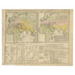
Maps of the Ancient World and the Posterity of Noah, 1820
Located in Langweer, NL
Two maps on one sheet. Hhand colored engraved lithograph, depicting the world as known to the Ancients on Mercator's projection and the Posterity of Noah. The first showns the Empire...
Category
Antique 19th Century Prints
Materials
Paper
Antique Map of France with an Inset Map of the Island of Corsica, c.1820
Located in Langweer, NL
Antique map titled 'Frankrijk naar de nieuwste bepalingen meerendeels gevolgd naar Lapie'. Beautiful map of France with an inset map of the island of Corsica. Includes a table with r...
Category
Antique 19th Century Dutch Maps
Materials
Paper
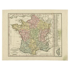
$170 Sale Price
20% Off
H 9.45 in W 12.21 in D 0 in
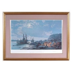
John Stobart (English, B. 1929), Independence, Ltd. Ed. Signed
By John Stobart
Located in Bridgeport, CT
"John Stobart (British b. 1929) paintings and limited edition prints are collected around the world and seen by visitors of the Peabody Museum in Massachusetts and the Portland Museum in Maine. He is well known maritime artist known for images of ports and vessels as they were in the great era of sail and stream".
INDEPENDENCE, Wayne City Landing, Start of the Santa Fe Trail...
Category
20th Century American Classical Prints
Materials
Glass, Wood, Paper
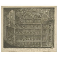
Original Old Print of the Theatre Royal, Drury Lane in London, 1820
Located in Langweer, NL
Antique print titled 'Interior of the late Theatre Royal Drury Lane (..)'.
Old print of the Theatre Royal, Drury Lane, as it was between 1794 and 1809 showing the tiers of boxes stage left and the chandelier-lit auditorium with a small party of visitors standing in one of the boxes, as if being shown around.
The Theatre Royal, Drury Lane, commonly known as Drury Lane, is a West End theatre and Grade I listed building in Covent Garden, London, England. The building faces Catherine Street (earlier named Bridges or Brydges Street) and backs onto Drury Lane. The building is the most recent in a line of four theatres which were built at the same location, the earliest of which dated back to 1663, making it the oldest theatre site in London still in use. According to the author Peter Thomson, for its first two centuries, Drury Lane could "reasonably have claimed to be London's leading theatre". For most of that time, it was one of a handful of patent theatres, granted monopoly rights to the production of "legitimate" drama in London (meaning spoken plays, rather than opera, dance, concerts, or plays with music).
The first theatre on the site was built at the behest of Thomas Killigrew in the early 1660s, when theatres were allowed to reopen during the English Restoration. Initially known as "Theatre Royal in Bridges Street", the theatre's proprietors hired prominent actors who performed at the theatre on a regular basis, including Nell Gwyn...
Category
Antique 1820s Architectural Models
Materials
Paper
Old Map of the Russian Empire, with English Language Text, Ca.1820
Located in Langweer, NL
Antique map titled 'Geographical, Statistical and Historical Map of Russia'.
Old map of the Russian Empire, encompassed on three sides by English language text. Originates from L...
Category
Antique 1820s Maps
Materials
Paper

$512 Sale Price
20% Off
H 17.72 in W 21.86 in D 0 in
Pl. 16 Antique Chart of the US Population 1790-1820 by Walker,
1874
Located in Langweer, NL
Antique chart titled 'The progress of the nation, 1790-1820. Maps showing in five degrees of density the distribution within the territory east of the 100th meridian of the populatio...
Category
Antique Late 19th Century Maps
Materials
Paper
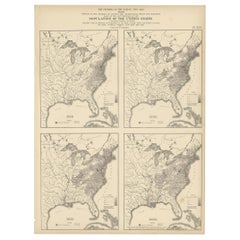
$534
H 21.66 in W 16.15 in D 0.02 in
Small Early 18th Century Map of Banten Bay on the Island Java, Indonesia, c.1725
Located in Langweer, NL
A small early 18th century map of Banten Bay showing the islands of Pulo Dua and Pulo Batto together with soundings within the Bay and profiles of hills on the islands published by C...
Category
Antique 1720s Maps
Materials
Paper
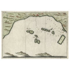
$208 Sale Price
20% Off
H 6.3 in W 8.59 in D 0 in
Old Engraving of the Battle of Chatham or Raid on Medway on the Thames, England
Located in Langweer, NL
Antique print titled 'Aftekening der Schilderye op 't Stadhuis te Dordrecht (..)'. Scene of the battle of Chattam during one of the many Anglo-Dutch wars. In this battle, the Dutch sailed up the river Thames and destroyed part of the English fleet at anchor in the harbor of Chattam. Pictured in the foreground is the Dutch commander, Cornelius de Wit, being presented with the spoils of war...
Category
Antique 18th Century Prints
Materials
Paper
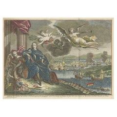
$417 Sale Price
20% Off
H 8.08 in W 11.23 in D 0 in
Antique Map of Asia by Brué
1820
Located in Langweer, NL
Antique map titled 'Carte de l'Asie'. Original antique map of Asia. A blind stamp near the title reads 'Carte Encyprotipe'. This map originates fro...
Category
Antique Early 19th Century Maps
Materials
Paper

Original Antique Map of Europe, Arrowsmith, 1820
Located in St Annes, Lancashire
Great map of Europe
Drawn under the direction of Arrowsmith.
Copper-plate engraving.
Published by Longman, Hurst, Rees, Orme and Brown, 1820
...
Category
Antique 1820s English Maps
Materials
Paper

More From This Seller
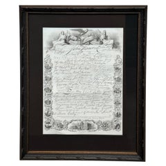
View All"Facsimile of the Signatures to the Declaration of Independence" by A.H. Wray
Located in Colorado Springs, CO
Presented is a handsome steel engraving, a patriotic composition of the facsimile signatures of the signers of the Declaration of Independence. The engraving is from John H. Hinton’...
Category
Antique 1850s American Federal Prints
Materials
Paper
“The Restaurant of the House of Representatives” Engraving by Harper
s Weekly
Located in Colorado Springs, CO
This original wood engraving is titled “The Restaurant of the House of Representatives, Washington, DC.” It was published as a double-page image, in the August 12, 1893 issue of the famous 19th century newspaper Harper’s Weekly. The print was illustrated by Charles Stanley Reinhardt.
The House Restaurant, a unique part of life in the Capitol, has been in the same location since the 1857 Capitol Expansion. Congressional members’ busy work schedule made the availability of food on site a necessity. But the restaurant also served as an informal meeting spot for members to continue conversations and deal making.
This 1893 print illustrates the convivial atmosphere. Details including elegantly dressed tables...
Category
Antique 1890s American Prints
Materials
Paper

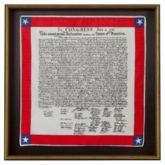
Declaration of Independence Printed Scarf
Located in Colorado Springs, CO
Presented is a patriotic silk scarf, celebrating the Declaration of Independence. At center of the silk scarf design is artistic rendering of the Declaration of Independence. The famous text and signatures are printed in black ink on white silk. A border of bright red encloses the text, with a five-pointed white star set against a blue square appearing at each corner. This is a newly made silk scarf, printed to celebrate our Nation's foundational text.
The United States Declaration of Independence...
Category
21st Century and Contemporary American Tapestries
Materials
Silk
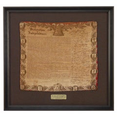
Declaration of Independence, Printed on Cotton, Circa 1876
Located in Colorado Springs, CO
Presented is a Centennial-era patriotic textile, celebrating the Declaration of Independence. At the center of the printed bandana design is artistic rendering of the Declaration of ...
Category
Antique 1870s American High Victorian Political and Patriotic Memorabilia
Materials
Cotton
1876 "Gettysburg, The Repulse of Longstreet
s Assault." Engraving
Located in Colorado Springs, CO
Presented here is an 1876 engraving of John B. Bachelder and James Walker’s Gettysburg. The Repulse of Longstreet’s Assault. The engraved scene depicts the decisive battle on the final day of the Battle of Gettysburg. Researched by the photographer and topographer John B. Bachelder and painted by James Walker, the original painting was created in 1870. This detailed engraving was done by H. B. Hall Jr. and published by James Drummond Ball.
Otherwise called Pickett’s Charge, the battle occurred on July 3, 1863. Pickett’s corp commander, Lieutenant General James Longstreet was placed in charge of the attack despite his hesitations. Longstreet’s central role led to the title of the work, Repulse of Longstreet’s Assault. In an attempt to gain control of an important supply route, nine Confederate brigades charged across three-quarters of a mile of open ground against cannon fire to take Cemetery Ridge from the defending Union Army. Despite their overwhelming numbers, the Confederate forces were repelled with considerable casualties marking not only a decisive victory for the Union, but also the beginning of the slow defeat of Lee’s Army. The furthest the charging forces advanced before being repulsed would forever be known as the “High Water Mark of the Confederacy.” The Confederate army never recovered from the losses at Gettysburg and it effectively ended Lee’s campaign into Pennsylvania.
The engraving gives the perspective from the Union rear, one that encompasses most of the battlefield, from Big Round Top on the left to the northern reaches of Cemetery Ridge on the right. The Confederate lines at Seminary Ridge are in the far distance, partially obscured by bursting shells. The image centers on the main Confederate assault, in the vicinity of what today are known as "The Copse" and "The Bloody Angle." The composition has elemen...
Category
Antique 1870s American Prints
Materials
Paper

N.E. View of the United States Capitol, Washington, DC Antique Proof Print 1858
Located in Colorado Springs, CO
This engraved print shows a view of the United States Capitol Building, in Washington, D.C. The print depicts the neoclassical building from the northeast orientation, with a bustling street scene in front. The steel engraving is a proof printing, drawn and engraved by Henry Sartain and published in 1858.
Plans began in May 1854 to build a new cast-iron dome for the United States Capitol. The then-architect of the Capitol Thomas Walter and his team were sold on the aesthetics of a new dome, as well as the utility of a fire-proof one. A year later, on March 3, 1855, President Franklin Pierce...
Category
Antique 1850s American Prints
Materials
Paper

Still Thinking About These?
All Recently ViewedMore Ways To Browse
Antique Broadside
Thai Statue Wood
Tibet Beads
Tibet Statue
Tiffany Feather
Tin Canister
Tree Bark Art
Two Geese
Used Furniture Worthing
Victorian Brush
Victorian Chest Drawers With Mirror
Vintage Airplane Sculpture
Vintage Bennington Pottery
Vintage Ceramic Pheasants
Vintage Dryer
Vintage Escutcheon Plate
Vintage Film Reel
Vintage French Trumpet