1 of 3
Extremely Rare Copy of the Venezuelan Declaration of Independance, 1811
$13,701.01List Price
About the Item
- Dimensions:Height: 33.08 in (84 cm)Width: 25.4 in (64.5 cm)Depth: 0.04 in (1 mm)
- Materials and Techniques:Paper,Engraved
- Place of Origin:Venezuela
- Period:
- Date of Manufacture:1811
- Condition:Wear consistent with age and use.
- Seller Location:Amsterdam, NL
- Reference Number:1stDibs: LU5458229707522
Authenticity Guarantee
In the unlikely event there’s an issue with an item’s authenticity, contact us within 1 year for a full refund. DetailsMoney-Back Guarantee
If your item is not as described, is damaged in transit, or does not arrive, contact us within 7 days for a full refund. Details24-Hour Cancellation
You have a 24-hour grace period in which to reconsider your purchase, with no questions asked.Vetted Professional Sellers
Our world-class sellers must adhere to strict standards for service and quality, maintaining the integrity of our listings.Price-Match Guarantee
If you find that a seller listed the same item for a lower price elsewhere, we’ll match it.Trusted Global Delivery
Our best-in-class carrier network provides specialized shipping options worldwide, including custom delivery.You May Also Like
Extremely Rare Map of the East-Indies towards the South-East
Indonesia
, 1725
Located in Langweer, NL
Antique map titled 'La partie des Indes Orientales vers le Zud-Est, depuis Timor jusqu'a Midanao (...).' (The part of the East-Indies towards the South-East, from Timor to Mindanao.)...
Category
Antique 1720s Maps
Materials
Paper
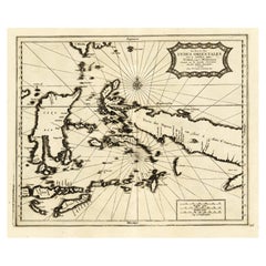
$1,096 Sale Price
20% Off
H 14.97 in W 19.3 in D 0 in
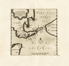
Extremely Rare Map of The land of Eso or Hokkaido in Japan, 1725
Located in Langweer, NL
Plate 46: 'Le Pais d' Eso.' (The land of Eso / Hokkaido in Japan.) Extremely rare in this edition.
This plate originates from the very scarse: 'La Galerie Agreable du Monde (..). T...
Category
Antique 18th Century Maps
Materials
Paper
Antique Map of the Swabia Region of Germany by Cary,
1811
By John Cary
Located in Langweer, NL
Antique map titled 'A New Map of the Circle of Swabia'. Antique map of Swabia in Southwestern Germany. Covers from the Upper Rhine region south as far as Switzerland, Lake Constance ...
Category
Antique Early 19th Century Maps
Materials
Paper

Antique Map of the Upper and Lower Rhine by Cary, 1811
By John Cary
Located in Langweer, NL
Antique map titled 'A New Map of the Circles of the Upper and Lower Rhine'. Antique map covering an area from Westphalia and Lower Saxony in the north to France and Swabia in the south.
Category
Antique Early 19th Century British Maps
Materials
Paper

Antique Map of Scotland by Cary,
1811
Located in Langweer, NL
Antique map titled 'A New Map of Scotland from the Latest Authorities':
**Title**: A New Map of Scotland from the Latest Authorities
**Publisher**: J....
Category
Antique Early 19th Century Maps
Materials
Linen, Paper

Antique Print View of Tula, the Sheffield of Russia, Near Moscow, Russia, 1811
Located in Langweer, NL
Antique print titled 'View of Tula, the Sheffield of Russia, in the approach from Moscow'. View of Tula, Russia. This print originates from 'Travels in Various Countries of Europe, A...
Category
Antique 19th Century Prints
Materials
Paper

$133 Sale Price
20% Off
H 8.67 in W 10.83 in D 0 in
Antique Map of Franconia, a region of Germany,
1811
By John Cary
Located in Langweer, NL
Antique map titled 'A New Map of the Circle of Franconia'. Detailed map of Franconia in Northwestern Germany. Covers from Upper Saxony south to Swabia, west to the Lower Rhine and we...
Category
Antique Early 19th Century Maps
Materials
Paper

Antique Print of Edward, Prince of Wales, by Hill, 1811
Located in Langweer, NL
Antique print titled 'Edward Prince of Aquitain & Wales Duke of Cornwall & Earl of Chester'. Old print of Edward, Prince of Wales, the Black Prince. Orig...
Category
Antique 19th Century Prints
Materials
Paper
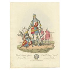
$228 Sale Price
20% Off
H 13.59 in W 10.24 in D 0 in
Antique Map of Bavaria and Salzburg by Cary, 1811
By John Cary
Located in Langweer, NL
Antique map titled 'A New Map of the Circle of Bavaria'. Antique map of Bavaria and Salzburg, Germany. Covers the Duchy of Bavaria and the mountainous A...
Category
Antique Early 19th Century Maps
Materials
Paper

Original Handcolored Antique Print of Arthur Mc Murroch, 1811
Located in Langweer, NL
The antique print titled "Arthur Mc. Murroch King of Leinster" depicts Arthur Mc. Murroch, a historical figure portrayed as the King of Leinster. The artwork originates from "Selections of the Ancient Costume...
Category
Antique 19th Century Prints
Materials
Paper
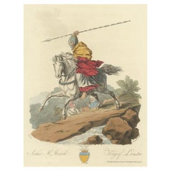
$228 Sale Price
20% Off
H 14.38 in W 10.24 in D 0 in
Still Thinking About These?
All Recently ViewedMore Ways To Browse
Antique Broadside
Chinese Antique Clocks
Chinese Bonsai
Chinese Export Roosters
Chinese Jade Dragon
Chinese Official Chair
Chinese Porcelain Guanyin
Chinese Porcelain Square
Chinese Qing Dynasty Ginger Jars
Chinese Roof Tiles
Chinese Taoist
Chinese Tool
Chip Carved Furniture
Christ Statue
Cigar Matches
Clay Sphere
Crank Handle
Custom Display Case