Want more images or videos?
Request additional images or videos from the seller
1 of 4
G.D. Giles Polo Picture
Price:$1,638.08
About the Item
- Creator:Geoffrey Douglas Giles (Artist)
- Dimensions:Height: 25.4 in (64.5 cm)Width: 35.24 in (89.5 cm)Depth: 0.04 in (1 mm)
- Place of Origin:
- Period:1900-1909
- Date of Manufacture:1904
- Condition:
- Seller Location:Oxfordshire, GB
- Reference Number:Seller: 270401stDibs: LU975710096593
About the Seller
5.0
Platinum Seller
Premium sellers with a 4.7+ rating and 24-hour response times
Established in 1977
1stDibs seller since 2013
832 sales on 1stDibs
Typical response time: 1 hour
Associations
LAPADA - The Association of Arts
Antiques Dealers
Authenticity Guarantee
In the unlikely event there’s an issue with an item’s authenticity, contact us within 1 year for a full refund. DetailsMoney-Back Guarantee
If your item is not as described, is damaged in transit, or does not arrive, contact us within 7 days for a full refund. Details24-Hour Cancellation
You have a 24-hour grace period in which to reconsider your purchase, with no questions asked.Vetted Professional Sellers
Our world-class sellers must adhere to strict standards for service and quality, maintaining the integrity of our listings.Price-Match Guarantee
If you find that a seller listed the same item for a lower price elsewhere, we’ll match it.Trusted Global Delivery
Our best-in-class carrier network provides specialized shipping options worldwide, including custom delivery.You May Also Like
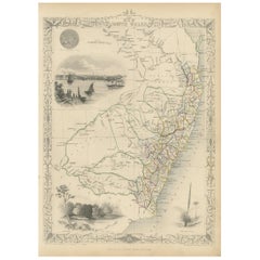
Antique Map of European Russia with Picture Frame Border
Located in Langweer, NL
Antique map titled 'La Moscovie Septentrionale (..)'. Decorative example of van der Aa's map of the northern part of European Russia. With the picture frame border, which appeared in...
Category
Antique Early 18th Century Maps
Materials
Paper
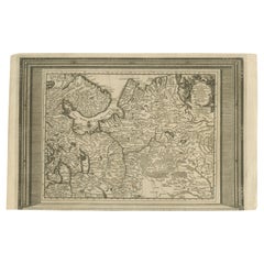
$363 Sale Price
20% Off
H 10.44 in W 16.54 in D 0.02 in
Antique Detailed Map of the Mountain Chains of Europe and Asia, c.1850
Located in Langweer, NL
Antique map titled 'The Mountain Chains of Europe & Asia'.
Old map depicting the mountain chains of Europe and Asia. Originates from 'The Physical Atlas of Natural Phenomena'.
Ar...
Category
Antique 19th Century Maps
Materials
Paper

$262
H 10.83 in W 14.18 in D 0 in
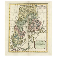
Decorative Antique Map of Sweden and Part of Finland, 1806
Located in Langweer, NL
Antique map titled 'La Suede.'
Decorative map of Sweden and part of Finland by Robert de Vaugondy, revised and published by Delamarche. Source unknown, to be determined.
Artists and Engravers: Made by 'Charles Francois Delamarche' after an anonymous artist. Charles Francois Delamarche (1740-1817) founded the important and prolific Paris based Maison Delamarche map publishing firm in the late 18th century. A lawyer by trade Delamarche entered the map business with the acquisition from Jean-Baptiste Fortin of Robert de Vaugondy's map plates...
Category
Antique Early 1800s French Maps
Materials
Paper
Old Map of the Gulf of Bothnia, the Northernmost Arm of the Baltic Sea, 1759
Located in Langweer, NL
Antique map titled 'Carte du Golphe de Bothnie'.
Original antique map of the Gulf of Bothnia, the northernmost arm of the Baltic Sea. It is situated between Finland's west coast ...
Category
Antique 1750s Maps
Materials
Paper
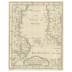
$229 Sale Price
20% Off
H 9.85 in W 7.49 in D 0 in
Antique Map of Sweden and Norway by W. G. Blackie, 1859
Located in Langweer, NL
Antique map titled 'Sweden and Norway'. Original antique map of Sweden and Norway. This map originates from ‘The Imperial Atlas of Modern Geography’. Published by W. G. Blackie, 1859.
Category
Antique Mid-19th Century Maps
Materials
Paper

$238 Sale Price
20% Off
H 21.26 in W 14.57 in D 0.02 in
Antique Map of South America by De la Harpe
1780
Located in Langweer, NL
Antique map titled 'Carte de l'Amerique Méridionale'. Original antique map of South America. Note the 'Laguna de Xarayes' is illustrated as the source of the Paraguay river. The laguna is now known as Pantanal, world's largest tropical wetland area. This map orginates from 'Abrégé de l'histoire générale des Voyages' by J.F. de la Harpe.
Category
Antique Late 18th Century Maps
Materials
Paper

$477 Sale Price
20% Off
H 19.69 in W 13.98 in D 0.02 in
Antique Map of Korea and Southern China by Bonne
1771
Located in Langweer, NL
Antique map titled 'Carte de la Tartarie Chinoise'. Original antique map of Korea and Southern China. Covers from the Lop Nor region eastward to K...
Category
Antique Mid-18th Century Maps
Materials
Paper
$549 Sale Price
20% Off
H 14.57 in W 20.28 in D 0.02 in
Antique Map of Styria by Mercator
circa 1650
Located in Langweer, NL
Antique map titled 'Stiria'. Original antique map of Styria, Austria. Published by G. Mercator, circa 1650.
Category
Antique Mid-17th Century Maps
Materials
Paper

Antique Map of New South Wales by Tallis, circa 1851
Located in Langweer, NL
Antique map titled 'New South Wales'. Decorative and detailed map of New South Wales which was drawn and engraved by J. Rapkin (vignettes by H. Warren ...
Category
Antique Mid-19th Century English Maps
Materials
Paper
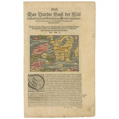
Antique Map of Denmark by Münster
1588
Located in Langweer, NL
Antique map titled 'Beschreibung des Königreichs Dennmarck (..)'. Early map of Denmark. This map originates from 'Cosmographey Oder beschreibung Aller Länder (..)' by Sebastian Münster.
Category
Antique 16th Century Maps
Materials
Paper
More From This Seller
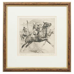
View AllPolo Engraving, California Polo by Reinhold H. Palenske
Located in Oxfordshire, GB
California Polo Etching.
A wonderful dry-point etching of Polo in America by American artist Reinhold H. Palenske (1884-1953). Inscribed and signed by th...
Category
20th Century American Sporting Art Prints
Materials
Paper
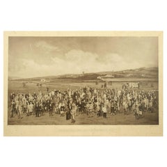
Antique Golf Print, Royal North Devon Golf Club, Photogravure of Westward Ho
Located in Oxfordshire, GB
Royal North Devon Golf Club 1893 by Mayall & Co. Ltd.
A great image of the members of the 'Royal North Devon Golf Club, Westward Ho!' from 1893. The figures are all photographs superimposed onto a painted background of the course. In the margin is printed 'Permanent Autotype, Produced by Mayall & Co. Ltd. 73 Piccadilly'. The image appears very much photographic but is more of a photomechanical print rather than a photograph.
John Jabez Edwin Paisley Mayall (1813-1901) was an English photographer who in 1860 took the first carte-de-visite photographs of Queen Victoria.
Taken from Royal North Devon:-
Royal North Devon at Westward Ho! Can rightly claim to be the cradle of English Golf. Founded in 1864, it is the oldest golf course in the country and is regarded as the St Andrews of the South. The golf course is as tough as any of the UK's more famous links layouts and has recently been placed in Golf World 's 'Top 100 Courses in the World' that a golfer 'must play'.
Not only is Royal North Devon a great course, it is also a place of huge historical importance. Inside the warmly welcoming clubhouse, the golf museum, honours boards and the clubs top competition trophies are worth a visit on their own and help to tell the story of the game and this remarkable club's unique place in it.
Above all, this is great, natural golf that is largely unchanged from 100 years ago when Harold Hilton et al pronounced Westward Ho! As England's No 1 competition golf course. RND is pure, raw exhilaration and ultimately the experience of playing a fast running links in a stiff breeze still tests the very best in the game.
Many of the great players of the last 100 years were regular competitors at RND but the greatest of them all is without doubt John Henry Taylor...
Category
Antique 1890s British Sporting Art Sports Equipment and Memorabilia
Materials
Paper
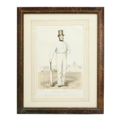
Antique Cricket Print of Joseph Guy of Nottingham
Located in Oxfordshire, GB
Cricket print of Joseph Guy of Nottingham.
A framed, tinted and hand colored lithographic portrait of the All- England cricketer Joseph Guy (1813 - 187...
Category
Antique 1850s British Sporting Art Sports Equipment and Memorabilia
Materials
Paper
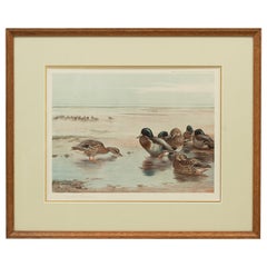
Antique Wildfowl Print Mallards Feeding by Archibald Thorburn
Located in Oxfordshire, GB
Mallards by Archibald Thorburn.
A framed wildfowl colotype print by Archibald Thorburn, signed in pencil by the artist and bearing fine Art Trade Guild blind stamp. Copyright Publis...
Category
Vintage 1920s British Sporting Art Prints
Materials
Paper
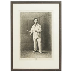
Antique Real Tennis Print, Charles Delahaye, Biboche
Located in Oxfordshire, GB
Real tennis print, Charles Delahaye, Biboche, Jeu De Paume, Joueur De Paume.
A wonderful rare original 1870s etching of Charles Delahaye, born in 1825 an...
Category
Antique Late 19th Century European Sporting Art Prints
Materials
Paper
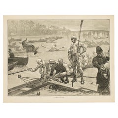
Antique Rowing Print, Cambridge University
Located in Oxfordshire, GB
Cambridge preparing for the boat race.
A wonderful atmospheric rowing lithograph of the Cambridge crew getting into a rowing scull preparing for a race....
Category
Antique 1890s British Sporting Art Prints
Materials
Paper
Still Thinking About These?
All Recently ViewedMore Ways To Browse
Paradise Bird Print
Achille Comte
Antique Chainmail
Antique Native American Prints
Antique Print Engraving Paris
Butterfly Engraving
Irish Prints Of Ireland
Sandwich Islands
Sea Shell Prints
French Botanical Prints
Funeral Antique
Pair Botanical Prints
Antique Palm Prints
Dutch Navy
Italian 19th Century Engravings
Les Lalanne
Serigraph 1980s
Antique Bat Print