1 of 1
Lizard, 1719
$6,250List Price
About the Item
- Creator:Maria Sibylla Merian (Artist)
- Dimensions:Height: 10.5 in (26.67 cm)Width: 15 in (38.1 cm)Depth: 0.5 in (1.27 cm)
- Style:Other (In the Style Of)
- Place of Origin:
- Period:
- Date of Manufacture:1719
- Condition:
- Seller Location:Houston, TX
- Reference Number:1stDibs: LU129322134032
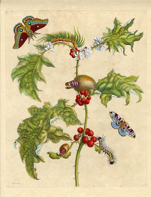
Maria Sibylla Merian
Maria Sibylla Merian (1647—1717) was a naturalist and artist. Her contributions to entomology were never appropriately recognized in her lifetime. She is now considered to be a pioneer in the fields of botany and zoology. She made detailed observations of live specimens, which was a departure from previous studies that used preserved specimens. She focused great detail on the processes of metamorphosis, which had not been studied so comprehensively before her work. The engravings for the publication were done by J. Mulder, P. Sluyter and A. Stopendaal, all after paintings on vellum by Merian. The work is considered to be one of the most beautiful, and famous illustrated natural history works of the 18th century. The work was the result of Merian's trip in 1699 with her daughter Dorothea to Surinam, a Dutch colony on the northeastern coast of South America. The pair studied and recorded plants and insects for two years under difficult conditions. They came back to Amsterdam with specimens, notes and drawings and there completed their astounding work. One naturalist proclaimed "Her portrayals of living insects and other animals were imbued with a charm, a minuteness of observation and an artistic sensibility that had not previously been seen in a natural history book; if Gould and Audubon have 'a spiritual ancestor, then it is difficult to think of a more worthy claimant to the title than Maria Sibylla Merian." On the day Maria Sibylla Merian died, Tsar Peter the Great purchased a two-volume collection of her unbound paintings, as well as her journal. Born in Frankfurt am Main, Maria Sibylla Merian was the daughter of Matthaus Merian the Elder (1593—1650), a famous German-Swiss painter, engraver and publisher. Her father died when she was three and her mother remarried Jacob Marrel (1614-1681), who was a still-life painter. From the time she was eleven, Marrel schooled Maria Sibylla Merian in the tradition of northern European still life painting, working directly from life. As her interests evolved toward the study of insects, she employed these artistic skills to create her outstanding scientific and esthetically beautiful works. She was truly at the crossroads of art and science.
Authenticity Guarantee
In the unlikely event there’s an issue with an item’s authenticity, contact us within 1 year for a full refund. DetailsMoney-Back Guarantee
If your item is not as described, is damaged in transit, or does not arrive, contact us within 7 days for a full refund. Details24-Hour Cancellation
You have a 24-hour grace period in which to reconsider your purchase, with no questions asked.Vetted Professional Sellers
Our world-class sellers must adhere to strict standards for service and quality, maintaining the integrity of our listings.Price-Match Guarantee
If you find that a seller listed the same item for a lower price elsewhere, we’ll match it.Trusted Global Delivery
Our best-in-class carrier network provides specialized shipping options worldwide, including custom delivery.You May Also Like
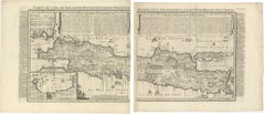
Antique Map of Java
Indonesia
by Chatelain, 1719
Located in Langweer, NL
Antique map titled 'Carte de l'Ile de Java: Partie Occidentale, Partie Orientale, Dressee tout Nouvellement Sur Les Memoires Les Plus Exacts (..)'. This beautiful map of Java exists ...
Category
Antique Early 18th Century Maps
Materials
Paper
Antique Print of Estate Vijverhof by Stoopendaal, 1719
Located in Langweer, NL
Antique print titled 'Vyverhof, de lust-plaats van den Hr. Benjamin Teixera (..)'. This print shows Vijverhof, the estate of Mr. Benjami Teixera. The estate is situated near the Vech...
Category
Antique 18th Century Prints
Materials
Paper
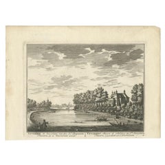
$268 Sale Price
20% Off
H 7.49 in W 10.24 in D 0 in
Original Old Print of a Blue Skink Lizard, a Striped Lizard and a Triton Lizard
Located in Langweer, NL
Original beautiful hand-colored print of Lizards.
"Scinque bleu" translates to "Blue Skink" in English. The term refers to a type of lizard from the skink family that features a bl...
Category
Antique 1840s Prints
Materials
Paper
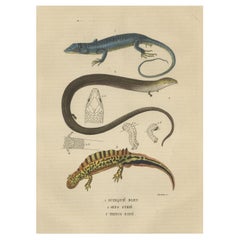
$153 Sale Price
20% Off
H 10.44 in W 6.7 in D 0 in
Antique French Map of Java, Indonesia by Chatelain,
1719
Located in Langweer, NL
Antique map titled 'Carte de l'Ile de Java: Partie Occidentale, Partie Orientale, Dressee tout Nouvellement Sur Les Memoires Les Plus Exacts (..)'. This beautiful map of Java (Indone...
Category
Antique Early 18th Century Maps
Materials
Paper

$1,832 Sale Price
45% Off
H 17.52 in W 36.82 in D 0.02 in
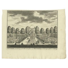
Antique Print of the
Nieuwerhoek
Estate by Stoopendaal, 1719
Located in Langweer, NL
Antique print Loenen titled 'Nieuwerhoek van binnen, op het Huis aen te sien'. Depicts Nieuwerhoek, the estate of Mr. Jan van Tarelink. Originates from 'De zegepralende Vecht', 1719....
Category
Antique 18th Century Prints
Materials
Paper
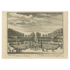
Antique Print of the
Ouderhoek
Estate by Stoopendaal, 1719
Located in Langweer, NL
Antique print titled 'Ouderhoeks, gesigt, bij de Karper-Vyver, door de Berceaux naer het Bergje'. Depicts Ouderhoek, the estate of Mr. Anthonie van den Hoek. Originates from 'De zege...
Category
Antique 18th Century Prints
Materials
Paper
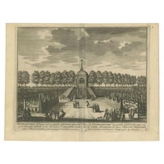
Antique Print of the Petersburg Estate by Stoopendaal, 1719
Located in Langweer, NL
Antique print titled 'Petersburgs Gesigt van 't groote Cabinet (..)'. View of the Petersburg Estate near Nigtevecht, the Netherlands. This print originates from 'De zegepraalende Vec...
Category
Antique 18th Century Prints
Materials
Paper
Antique Print of Fortress Nieuwersluis in the Netherlands, 1719
Located in Langweer, NL
Antique print titled 'De Schans Nieuwersluis (..)'. This print shows fortress Nieuwersluis, as seen towards Ouderhoek. With draw bridge over the Vecht river. Originates from 'De Zegepraalende Vecht, vertoonende verscheidene Gesichten van Lustplaatsen, Heeren Huysen en dorpen, beginnen van Uitrecht en met Muyden besluytende' published in Amsterdam by Andries de Leth / Wed. Nicolaas Visscher, 1719.
Artists and Engravers: Daniel Stoopendaal (Dutch) was active in Amsterdam from 1685 to 1713. Both Daniel and Bastiaan Stoopendaal made maps for the so-called Keur Bibles (published from 1666-1756). Most probably both were not related. Bastiaan worked mostly in the circle of Nicolaes Visscher. Daniel engraved topographical prints...
Category
Antique 18th Century Prints
Materials
Paper
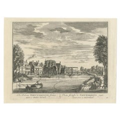
$248 Sale Price
20% Off
H 6.89 in W 9.06 in D 0 in
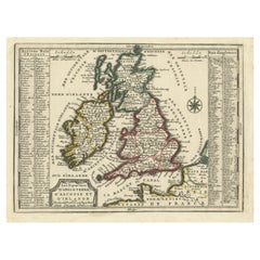
Map of the British Isles with Historical Kings, 1719
Located in Langweer, NL
This antique map, titled "Les Royaumes d'Angleterre d'Escosse et d'Irlande," offers a detailed view of the British Isles, including England, Wales, Scotland, and Ireland. Additionall...
Category
Antique Early 18th Century Maps
Materials
Paper
$421 Sale Price
20% Off
H 7.64 in W 9.93 in D 0.02 in
Antique Map of the British Isles by H. Chatelain, 1719
By Henri-Abraham Chatelain
Located in Langweer, NL
Beautiful hand colored large format map of the British Isles, with large insets of the Eastern and Western Hemispheres and the coats of arms for Engl...
Category
Antique Early 18th Century Maps
Materials
Paper
