Items Similar to Lough Derg, Donegal – Antique Irish Pilgrimage Map Engraving c.1700


Video Loading
Want more images or videos?
Request additional images or videos from the seller
1 of 13
Lough Derg, Donegal – Antique Irish Pilgrimage Map Engraving c.1700
$144.13
£106.86
€120
CA$198
A$216.15
CHF 113.80
MX$2,589.20
NOK 1,455.52
SEK 1,328.91
DKK 914.36
About the Item
Lac Derg in der Graffschafft Donegal - (Lough Derg in County Donegal).
This engraving shows the pilgrimage island in Lough Derg, famous since the Middle Ages as a site of penitential pilgrimage associated with St. Patrick’s Purgatory. The map is oriented with north to the right (as indicated by the small compass). It depicts churches, chapels, cells, and tombs of saints, including references to St. Patrick, St. Brendan, and St. Columba, all key figures in Irish Christian tradition.
This style of engraving, along with the German text, suggests it comes from a late 17th to early 18th-century continental publication describing Ireland. Many such engravings appeared in travel and history works printed in Nuremberg and Frankfurt around 1680–1720 (for example, works by Gabriel Bodenehr or Johann Christoph Weigel). The engraved number at top right (43) indicates it was part of a series or book.
Title: Antique Map of Lough Derg – St. Patrick’s Purgatory, Donegal, c.1700
This rare early engraved map presents a bird’s-eye plan of Lough Derg in County Donegal, Ireland, focusing on the famous pilgrimage site known as St. Patrick’s Purgatory. For centuries, this island on Lough Derg was one of the most important pilgrimage destinations in Ireland, attracting pilgrims from across Europe who sought spiritual purification.
The engraving, with German title “Lac Derg in der Graffschafft Donegal”, was produced around 1700 for a continental European audience, eager for descriptions of Irish religious traditions. The map shows the pilgrimage island in detail, including chapels, monastic cells, and marked graves of saints such as St. Patrick, St. Brendan, and St. Columba. A church dominates the central area, while circular enclosures, labeled tombs, and penitential stations reflect the deep spiritual association of this place. A small ship at right emphasizes both the remoteness and accessibility of the island across the lough.
Engravings such as this offered continental readers a fascinating glimpse into Irish Catholic practices, especially at a time when Catholic pilgrimage was under pressure in Ireland itself due to political and religious conflicts. Today, these prints are prized by collectors of Irish history, religious iconography, and early cartography for their rarity and cultural resonance.
Condition report:
Fair condition for age, with dark impression and fine detail. A small corner teared off and light trimming and handwritten numbering at the top margin, and some creasing to the edges of the sheet. The engraved image is clean and well-preserved, mounted to paper.
Framing tips:
This engraving would display beautifully in a simple dark wood or black frame with a cream mount, which would emphasize the rich linework and antiquarian character. A frame with gilt accents would add gravitas for collectors of Irish historical prints.
Technique: Engraving on laid paper
Maker: German engraver/publisher, c.1700 (possibly Bodenehr or Weigel, Nuremberg)
- Dimensions:Height: 6.5 in (16.5 cm)Width: 8.08 in (20.5 cm)Depth: 0.01 in (0.2 mm)
- Materials and Techniques:Paper,Engraved
- Place of Origin:
- Period:
- Date of Manufacture:circa 1700
- Condition:Fair condition for age, with dark impression and fine detail. A small corner teared off and light trimming and handwritten numbering at the top margin, some creasing to the edges.. The engraved image is clean and well-preserved, mounted on paper.
- Seller Location:Langweer, NL
- Reference Number:Seller: BG-14122-41stDibs: LU3054346377242
About the Seller
5.0
Recognized Seller
These prestigious sellers are industry leaders and represent the highest echelon for item quality and design.
Platinum Seller
Premium sellers with a 4.7+ rating and 24-hour response times
Established in 2009
1stDibs seller since 2017
2,811 sales on 1stDibs
Typical response time: 1 hour
- ShippingRetrieving quote...Shipping from: Langweer, Netherlands
- Return Policy
More From This Seller
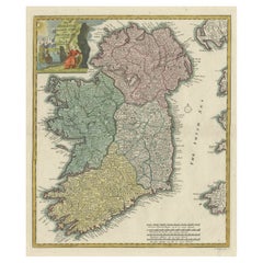
View AllDecorative Hand-Coloured Antique Map of the Four Irish Provinces, Ireland, c1718
Located in Langweer, NL
Title: Regni Hiberniae Accurata Tabula per Hermanum Moll
Decorative map of the four Irish provinces, Ireland, 1718, by Christoph Weigel (with credit to Herman Moll), engraved by Mi...
Category
Antique 1710s Maps
Materials
Paper
Ireland Antique Map – Royaume d’Irlande, De Vaugondy, Venice 1778
Located in Langweer, NL
Antique Map of Ireland – Royaume d’Irlande, Robert de Vaugondy, Venice 1778
Description:
This finely engraved 18th-century map depicts the Kingdom of Ireland under the title Royaume...
Category
Antique 1770s Italian Maps
Materials
Paper

Antique Map of the Bay of Bantam, c.1720
Located in Langweer, NL
Rare, untitled miniature map of the Bay of Bantam with various Islands including Pulo Dua and Pulo Batto. This map originates from a small travelogue and may originate from an editio...
Category
Antique 18th Century Maps
Materials
Paper

$57 Sale Price
20% Off
Hibernia Regnum Map by Carel Allard, 1700: Hand-Colored Provinces of Ireland
Located in Langweer, NL
This is a historical map of Ireland created by Carel Allard around 1700, titled "Hibernia Regnum in Quatuor Provincias Ultoniam, Connaciam, Lageniam, et Momoniam". The map is hand-colored and engraved. It includes two large decorative cartouches. The map is part of an atlas by Carel Allard, an Amsterdam-based cartographer.
Here are the detailed points about the map:
Maker: Carel Allard - a prominent Dutch cartographer and publisher from Amsterdam.
Atlas: Source Atlas - Likely part of an atlas published by Carel Allard, but specific title of the atlas isn't mentioned.
Interesting Features
1. Decorative Cartouches: The map features two large, ornate cartouches. One in the upper left depicts a classical figure and British Royal arms...
Category
Antique Early 1700s Maps
Materials
Paper

$2,017 Sale Price
30% Off
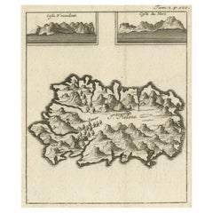
Map of Saint Helena Island: Early 18th-Century Copper Engraving by F. Bernard
Located in Langweer, NL
Map of Saint Helena Island: Early 18th-Century Copper Engraving by F. Bernard
This rare and beautifully detailed copper engraving of Saint Helena Island dates from around 1722 and...
Category
Antique 1720s Maps
Materials
Paper
Antique Map of the Bay and Island of Arguin by Van Schley, 1747
Located in Langweer, NL
Antique map titled ?Plan de la Baye et Isle d'Arguim (..) - Oppervlakte van de Baai en 't Eiland van Arguin (..)'. Original antique map of the bay and the island of Arguin. This map ...
Category
Antique 18th Century Maps
Materials
Paper

$94 Sale Price
20% Off
You May Also Like
Southeastern Ireland: A 17th Century Hand Colored Map by Mercator and Hondius
By Gerard Mercator
Located in Alamo, CA
A 17th century copperplate hand-colored map entitled "The Second Table of Ireland, Udrone" by Gerard Mercator and Jodocus Hondius, published in Amsterdam in 1635 in 'Cosmographicall ...
Category
1630s Landscape Prints
Materials
Engraving

Original Antique Map of Ireland- Kerry. C.1840
Located in St Annes, Lancashire
Great map of Kerry
Steel engraving
Drawn under the direction of A.Adlard
Published by How and Parsons, C.1840
Unframed.
Category
Antique 1840s English Maps
Materials
Paper

1636 Jansson Map of Ireland Entitled "Comitatus Lageniae, " Ric.a007
Located in Norton, MA
1646 Jansson map entitled
"Procinvia connactiae,"
Ric.a006
Description: The PROVINCE of CONNAVGT 490 x 380From vol 4 of Jansson's Atlas Novus 1646, published in Amsterdam with...
Category
Antique 17th Century Unknown Maps
Materials
Paper

Antique Map - Archipela Meridionalis - Etching by Johannes Janssonius - 1650s
By Johannes Janssonius
Located in Roma, IT
Antique Map - Archipela Meridionalis is an antique map realized in 1650 by Johannes Janssonius (1588-1664).
The Map is Hand-colored etching, with coeval watercolorang.
Good conditi...
Category
1650s Modern Figurative Prints
Materials
Etching

Map of Scotland - Etching by Johannes Blaeu - 1650s
Located in Roma, IT
Map of Scotland is an geographic map realized by Johannes Blaeu.
Etching, printed in 1660 ca.
Copper engraving, colored (coeval coloring), on paper, with center fold;
Latin text. ...
Category
1650s Modern Figurative Prints
Materials
Etching
$450 Sale Price
20% Off
Ancient Map - Zeilan - Etching by Johannes Janssonius - 1650s
By Johannes Janssonius
Located in Roma, IT
Ancient Map - Zeilan is an ancient map realized in 1650 by Johannes Janssonius (1588-1664).
The Map is Hand-colored etching, with coeval watercoloring.
...
Category
1650s Modern Figurative Prints
Materials
Etching
