Items Similar to Map Of The City Of Geneva, Framed Engraving, Late 18th Century

Video Loading
Want more images or videos?
Request additional images or videos from the seller
1 of 16
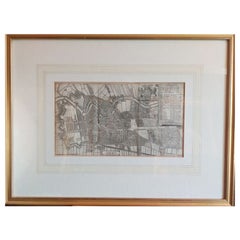
Map Of The City Of Geneva, Framed Engraving, Late 18th Century
$1,679.94
£1,244.94
€1,400
CA$2,295.99
A$2,499.37
CHF 1,326.67
MX$30,072.79
NOK 16,810.66
SEK 15,403.32
DKK 10,664.22
About the Item
Beautiful engraving representing the city of Geneva corrected in 1775 and 1793
The engraving also presents inserts with the evolution of the city, the plan of ancient Geneva and that in 1715, the map of the bailiwicks and the legend of the streets and buildings.
Engraving under glass, framed in a very beautiful 19th century frame in very richly carved wood
Late 18th century engraving, as is, with tears, folds, stains and foxing
Not examined out of frame
Dimensions with frame: 90 x 77 x 4cm
Dimensions of the engraving alone: 64 x 50 cm
- Dimensions:Height: 30.32 in (77 cm)Width: 35.44 in (90 cm)Depth: 1.58 in (4 cm)
- Style:Louis XV (Of the Period)
- Materials and Techniques:
- Place of Origin:
- Period:
- Date of Manufacture:unknown
- Condition:Wear consistent with age and use. Minor losses. Minor structural damages. Minor fading.
- Seller Location:MARSEILLE, FR
- Reference Number:1stDibs: LU6656246430252
About the Seller
5.0
Vetted Professional Seller
Every seller passes strict standards for authenticity and reliability
Established in 1999
1stDibs seller since 2022
27 sales on 1stDibs
Typical response time: <1 hour
- ShippingRetrieving quote...Shipping from: MARSEILLE, France
- Return Policy
More From This Seller
View AllFramed Engraving, View Of Gray Franche Comté, 18th Century?
Located in MARSEILLE, FR
Large framed engraving titled "View of the town of Gray Franche-Comté"
It bears the following notes: "is distributed in Paris by the author, in the hostel of the royal manufactur...
Category
Antique 18th Century French Louis XV Prints
Materials
Paper
Philae Island, framed engraving, XIXth century
Located in MARSEILLE, FR
Large framed engraving representing a view of the island and the temple of Philae: "general view taken from the North West side"
It bears the mentions "Balzac del", "Paris ag Fort" ...
Category
Antique 19th Century French Napoleon III Prints
Materials
Paper
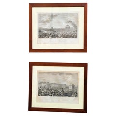
Pair Of Framed Engravings, French Revolution, 18th/19th Century
Located in MARSEILLE, FR
Pair of engravings illustrating 2 major episodes of the French Revolution:
* the day of August 10, 1792: the storming of the Tuileries ending with the arrest of Louis XVI and his ...
Category
Antique Early 19th Century Louis XVI Prints
Materials
Paper
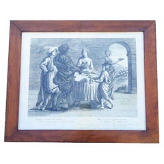
Interior Scene, Framed Engraving, 19th Century
Located in MARSEILLE, FR
Framed engraving depicting an animated interior scene of several characters around a table.
It bears the following description: "Il fumoso a smaltir cibo indigesto - non v'e piu ...
Category
Antique 19th Century Italian Louis XIII Prints
Materials
Paper
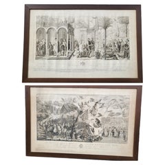
Panoramic Views Of Jerusalem In Scio, Framed Engravings, 19th Century
Located in MARSEILLE, FR
Pair of very large framed engravings representing panoramic views of the cities of Jerusalem and Scio (or Chios).
Some stains, foxing, tears and folds. 19th century period.
20...
Category
Antique 19th Century French Other Prints
Materials
Paper

Suite Of 2 Engravings, Camposanto De Pisa, Lasinio And Molini Landi
Cie, Empir
Located in MARSEILLE, FR
Suite of 2 large engravings from the Empire period, after the frescoes of the Camposanto in Pisa, the city's famous monumental cemetery, frescoes dating from the 14th century
The th...
Category
Antique Early 19th Century Italian Empire Prints
Materials
Paper
You May Also Like
Antique Map of the City of Paris by Tirion
1763
Located in Langweer, NL
Antique map titled 'Nieuwe Kaart der platte Grond van de Stad Parys (..)'. Beautiful city plan of Paris, France. This map originates from 'Nieuwe en Beknopte Hand-Atlas, bestaande in...
Category
Antique Mid-18th Century Maps
Materials
Paper

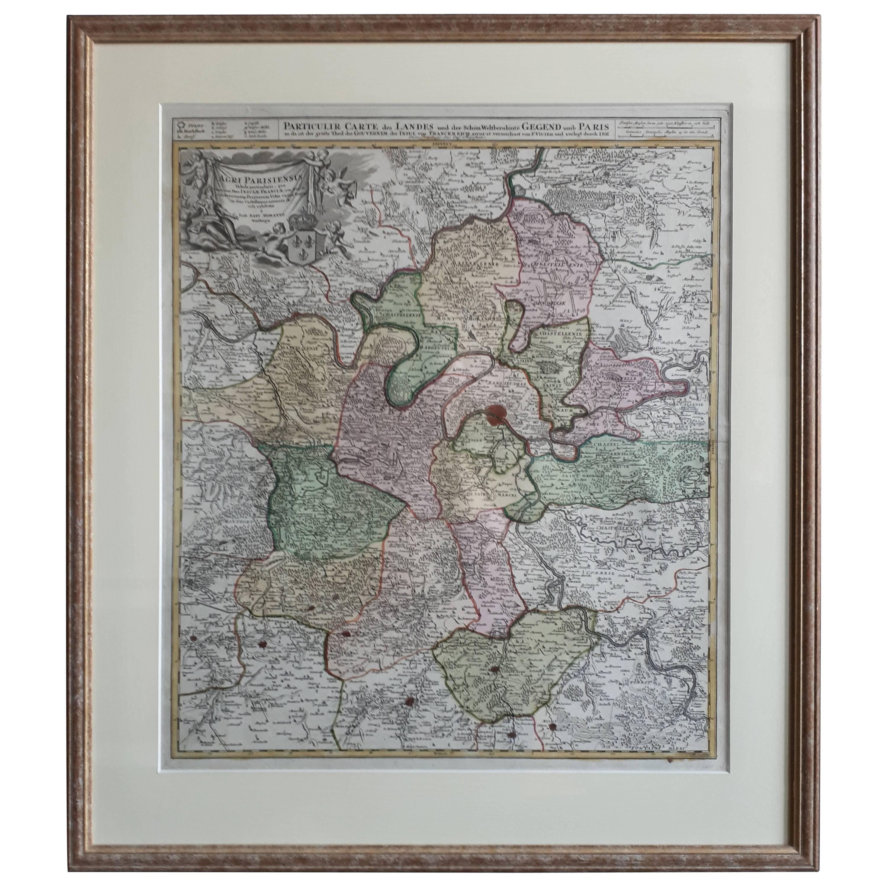
Antique Map in Frame of the Region of Paris ‘France’ by H. Heirs, circa 1720
Located in Langweer, NL
Antique map titled 'Agri Parisiensis Tabula particularis, qua maxima Pars Insulae Franciae (..)'. Incredibly detailed map showing everything from tiny villages to forests, farmland, ...
Category
Antique Early 18th Century German Maps
Materials
Paper

$1,055 Sale Price
20% Off
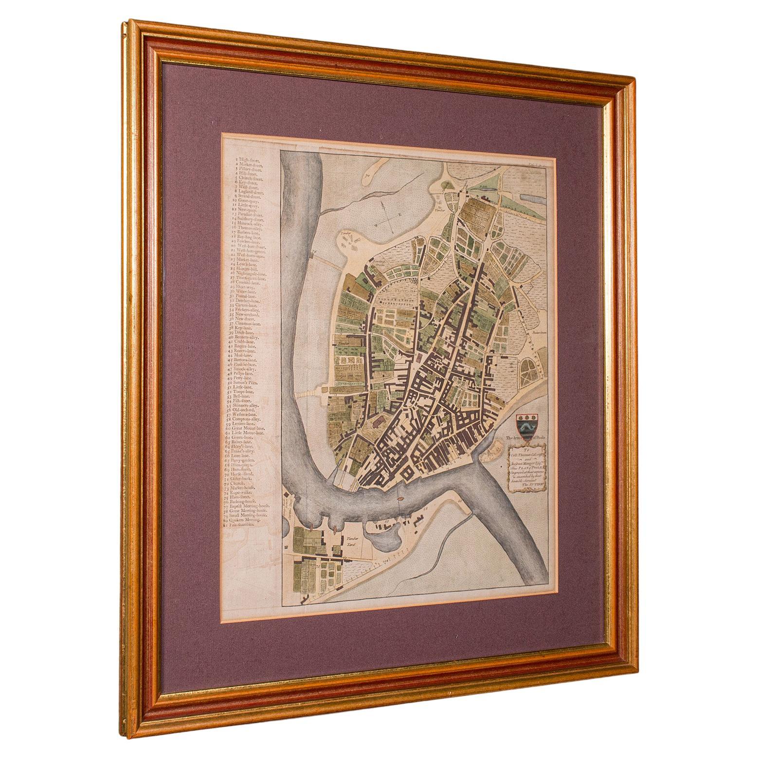
Antique Town Plan Map, Poole, English, Framed Cartography, Georgian, Circa 1780
Located in Hele, Devon, GB
This is an antique town plan map of Poole in Dorset. An English, framed atlas engraving, dating to the 18th century and later.
Fascinating cartography with annotated streets and pl...
Category
Antique Late 18th Century British George III Maps
Materials
Glass, Wood, Paper

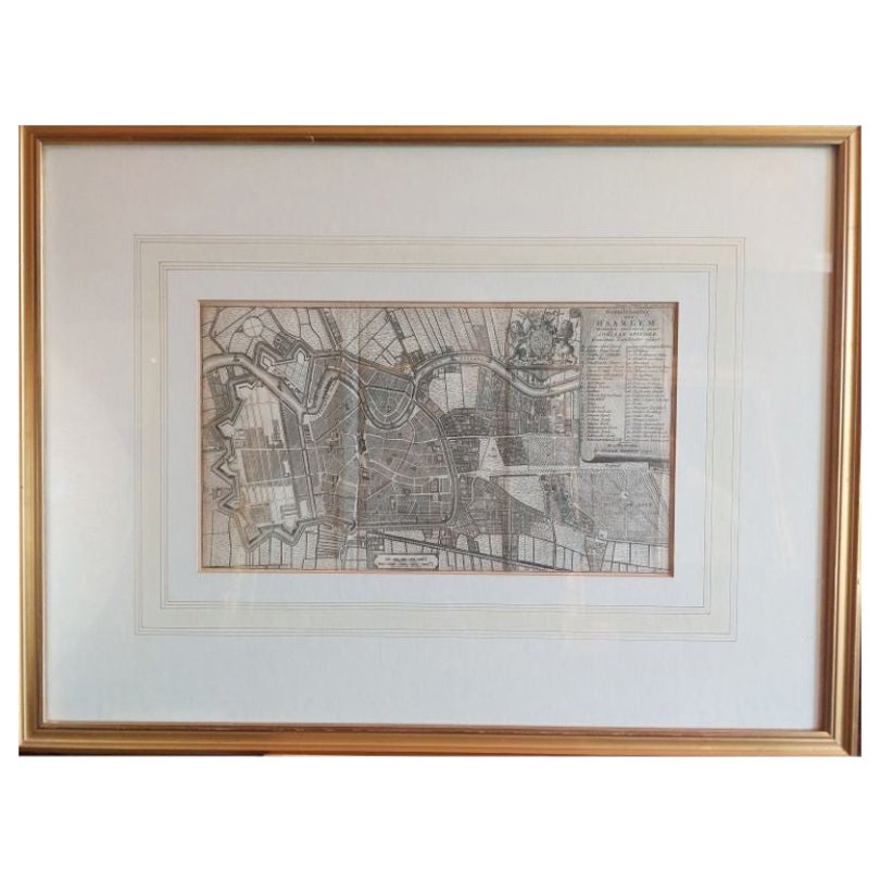
Antique Map of the City of Haarlem by Tirion, 1742
By Isaak Tirion
Located in Langweer, NL
Antique map titled 'Grondtekening van Haarlem (..)'. Original antique map of the city of Haarlem, the Netherlands. Published by I. Tirion, 1742.
Artists and Engravers: Isaak Tirio...
Category
Antique 18th Century Maps
Materials
Paper
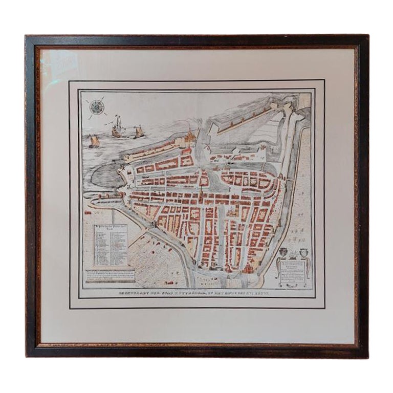
Antique City Plan of Rotterdam in Frame, ca.1850
Located in Langweer, NL
Antique map titled 'Grondkaart der stad Rotterdam (..)'. Original antique city plan of Rotterdam, the Netherlands. Published circa 1850.
Artists...
Category
Antique 19th Century Prints
Materials
Paper

$623 Sale Price
20% Off
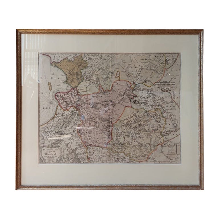
Antique Map of Overijssel by Visscher, c.1660
Located in Langweer, NL
Antique map titled 'Transisalania provincia vulgo Over-yssel'. Original antique map of the province of Overijssel, the Netherlands. Published by N. Visscher after N. ten Have, circa ...
Category
Antique 17th Century Maps
Materials
Paper

$709 Sale Price
20% Off