Items Similar to Mariners Chart of Marion Massachussets by George Eldridge 1901

Want more images or videos?
Request additional images or videos from the seller
1 of 12
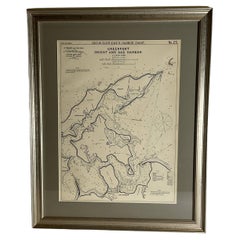
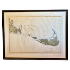
Mariners Chart of Marion Massachussets by George Eldridge 1901
$399
£304.33
€346.56
CA$560.72
A$611.54
CHF 323.95
MX$7,331.50
NOK 4,125.72
SEK 3,772.66
DKK 2,589.13
About the Item
Nautical chart showing the harbor and local waters of Marion Harbor., The chart displays depth, buoys, lighthouses, etc., Shown are Planting Island, Ram Island, Sippican Neck, Little Neck, Charles Neck, Rock Island, etc. (1821 - 1900) George Eldridge and his son George Washington Eldridge (1845-1912) were leading sea chart and sailing guide publishers from the mid 19th to the early twentieth century. George Eldridge was a fisherman who suffered an injury so he flourished as a cartographer. His bold easy to read charts were favored by mariners. He also issued an annual tide book. Dated 1901. Matted and framed.
Weight: 7 lbs.
Overall Dimensions: 27"H x 21"W
Made: America
Material: Paper
Date: 1901
- Dimensions:Height: 27 in (68.58 cm)Width: 21 in (53.34 cm)Depth: 1 in (2.54 cm)
- Materials and Techniques:
- Place of Origin:
- Period:1900-1909
- Date of Manufacture:1901
- Condition:
- Seller Location:Norwell, MA
- Reference Number:Seller: 85721stDibs: LU1741238241052
About the Seller
5.0
Gold Seller
Premium sellers maintaining a 4.3+ rating and 24-hour response times
Established in 1967
1stDibs seller since 2015
430 sales on 1stDibs
Typical response time: 8 hours
- ShippingRetrieving quote...Shipping from: Norwell, MA
- Return Policy
More From This Seller
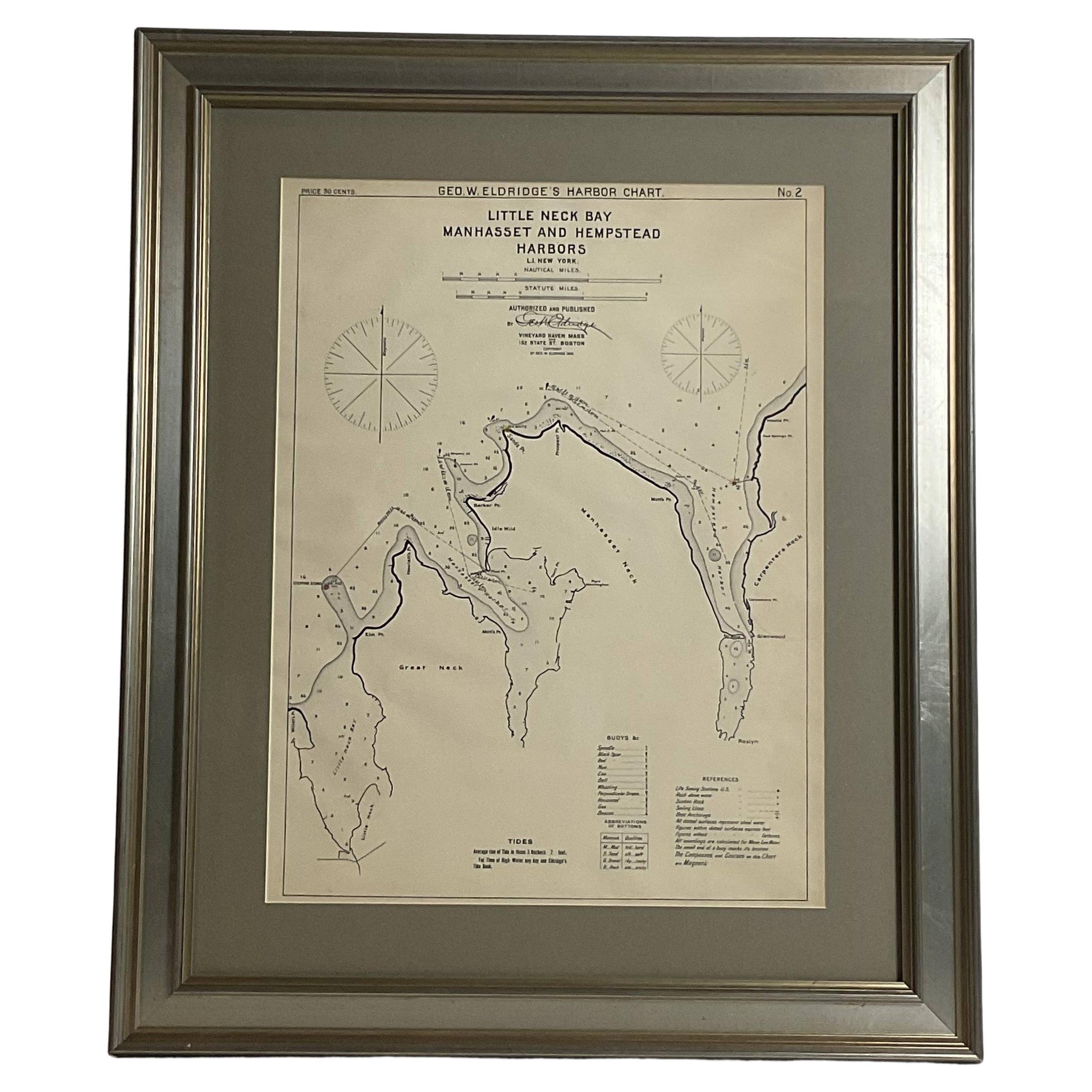
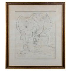
View AllMariners charts of Massachusett Long Island by George Eldridge 1901
Located in Norwell, MA
Nautical Chart showing the harbor and local waters of the Little Neck Bay, Manhasset and Hempstead Harbors. The chart displays depths, buoys, lighthouses, etc., Shown is Manhasset Ne...
Category
Antique Early 1900s North American Prints
Materials
Paper

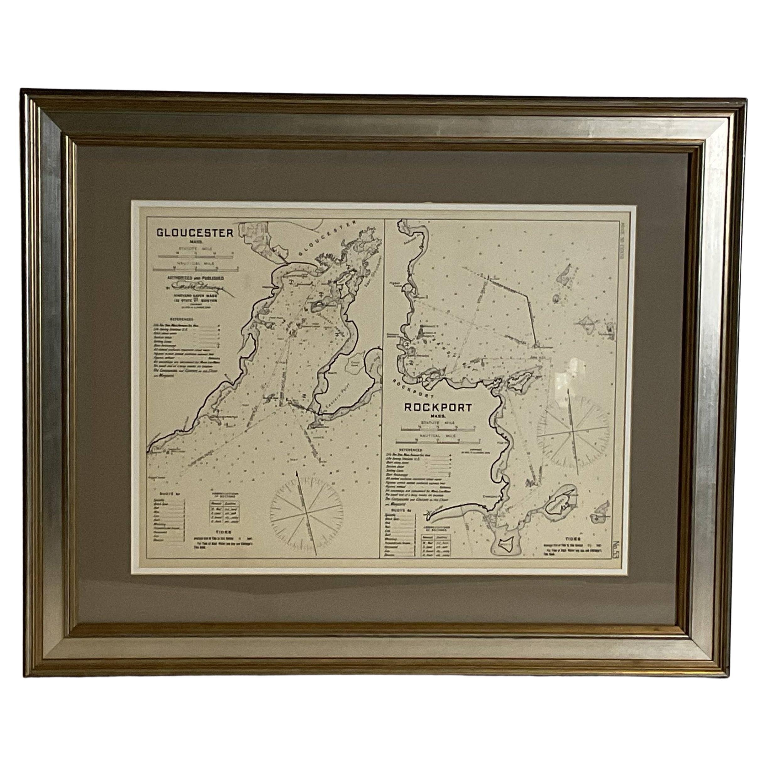
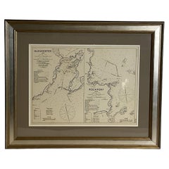
Mariners Chart of Gloucester and Rockport by George Eldridge 1910
Located in Norwell, MA
Nautical chart showing the harbor and local water. The chart display depths buoys, lighthouses, etc., This chart shows Eastern Point, Rocky Neck, Stage head, Thatcher Island, Sandy B...
Category
Vintage 1910s North American Prints
Materials
Paper
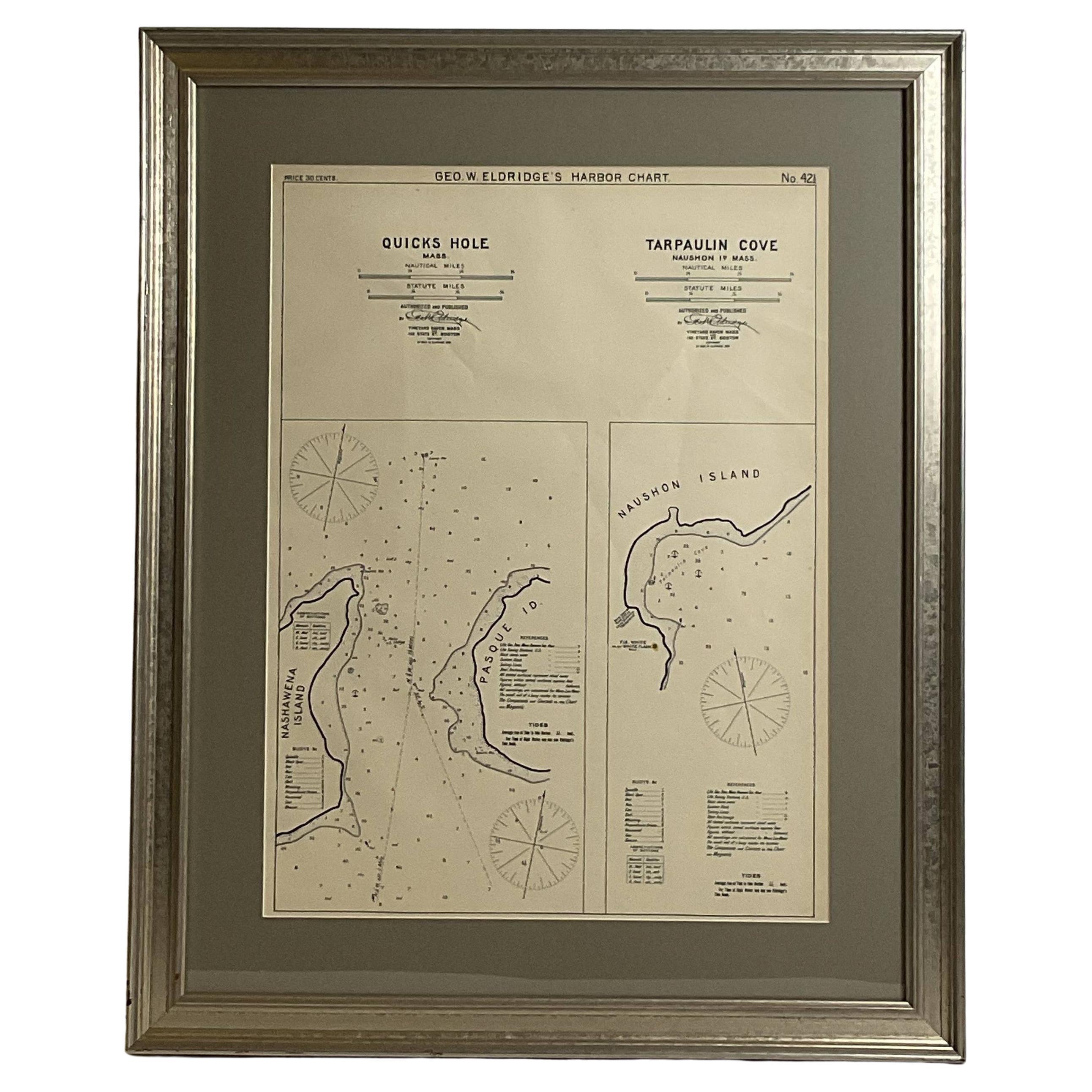
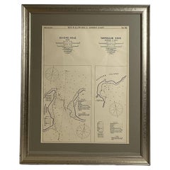
Mariners Chart of Quicks Hole and Tarpaulin Cove by George Eldridge 1901
Located in Norwell, MA
Nautical chart showing the harbor and local waters of Naushon Island Quick Holes. The chart display depths buoys, lightness, etc., The chart shows the cove in Naushon with ships stor...
Category
Antique Early 1900s North American Maps
Materials
Paper
Copy of 1901 Chart of Boston Harbor
Located in Norwell, MA
Later copy after an original Boston Harbor chart by George Eldridge of Vineyard Haven and Boston. Detailed chart of Boston Harbor from the Neponset River in Quincy south down to Kimb...
Category
Vintage 1910s North American Prints
Materials
Paper

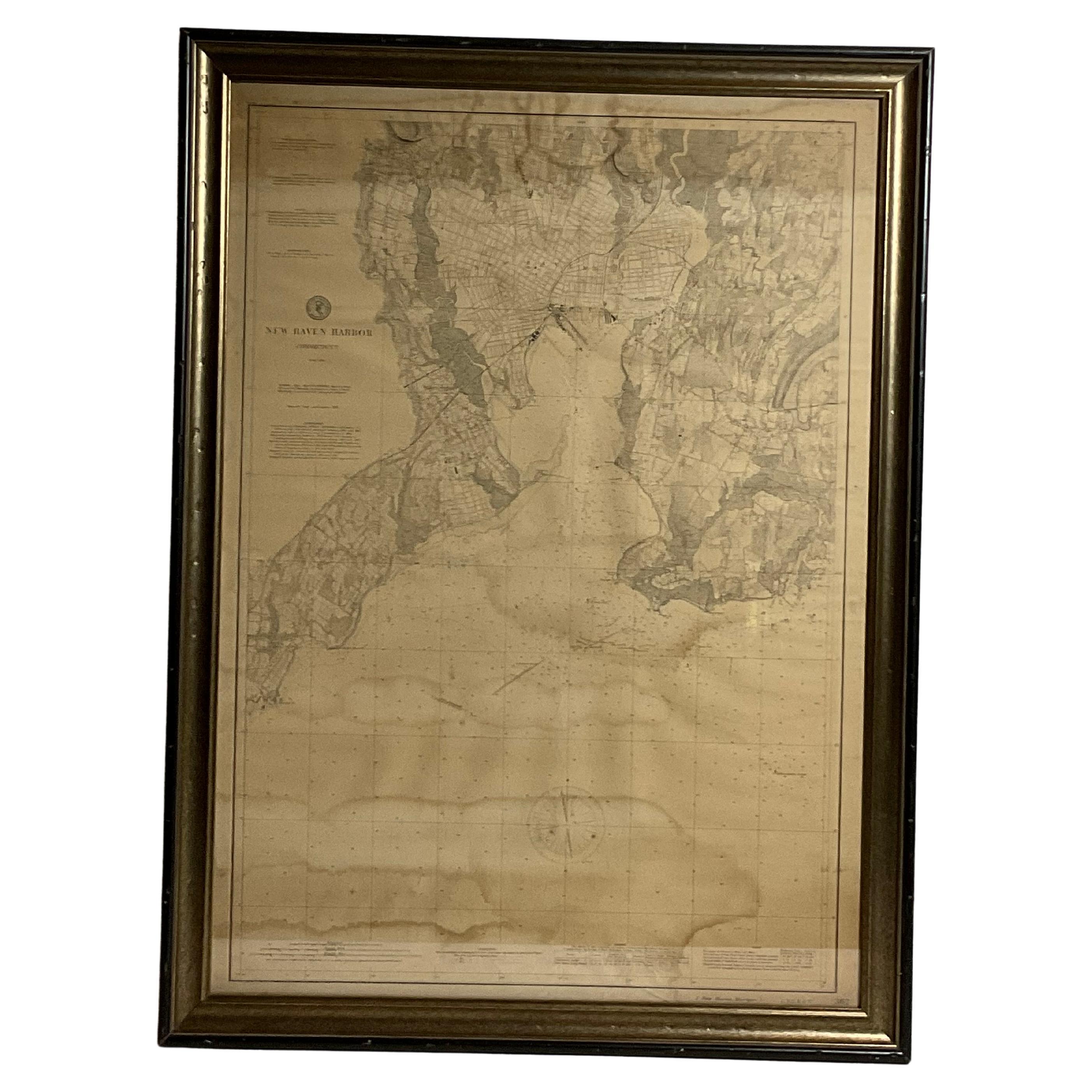
1896 Chart of the New Haven Harbor
Located in Norwell, MA
New Haven Harbor Chart published May 1896 by the United States Coast and geodetic survey. This chart is also a map of the land around the harbor and etc., loaded with detail. Nicely ...
Category
Antique 1890s North American Prints
Materials
Paper

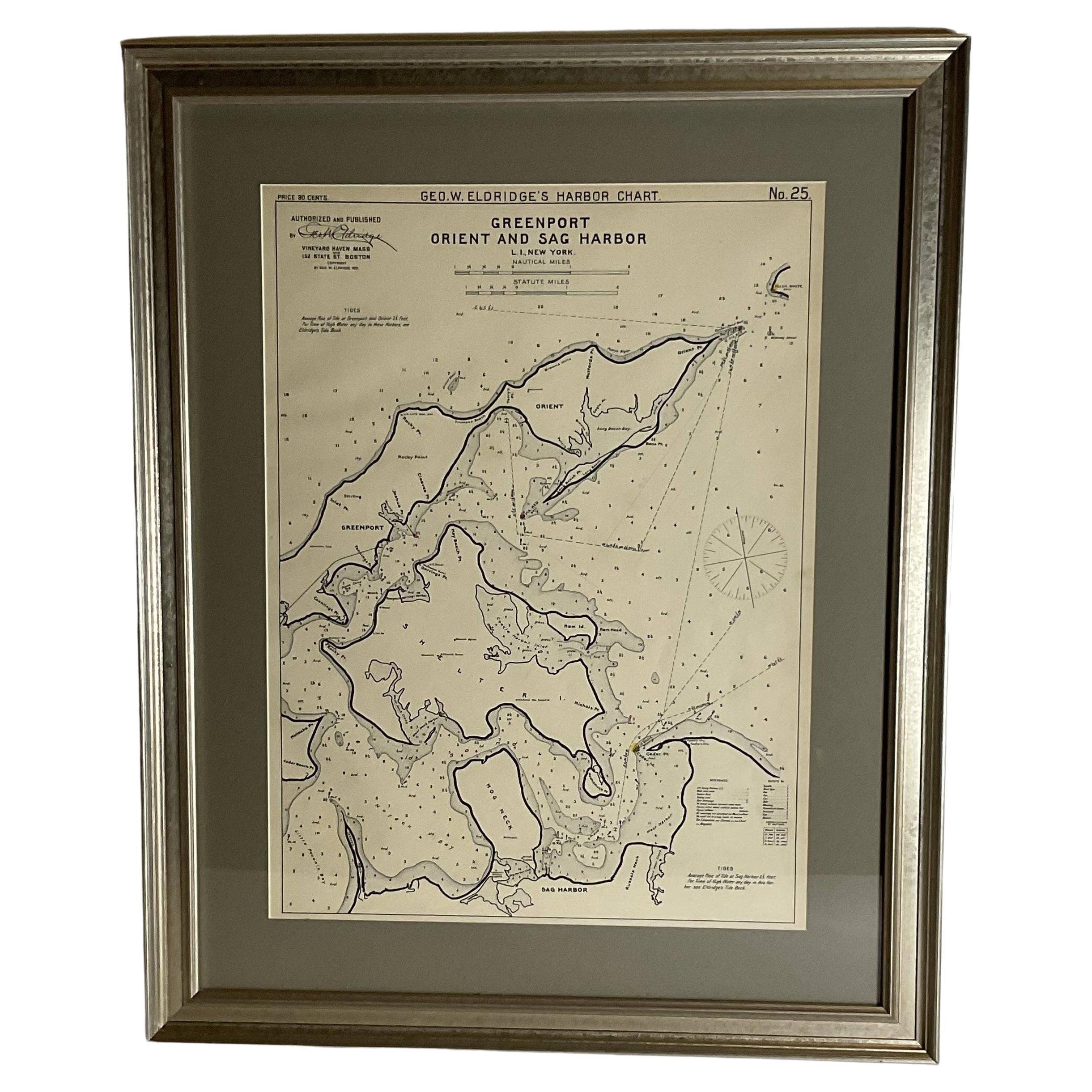
Sag Harbor Nautical Chart
Located in Norwell, MA
Marine chart of Greenport, Orient, and Sag Harbor New York published by George Eldridge in 1901. Details include the areas of Greenport, Orient, Shelter ...
Category
Antique Early 1900s Prints
Materials
Paper
You May Also Like
19th Century Chart of New England Coast, 1847
By U.S. Government
Located in Nantucket, MA
19th Century Chart of New England Coast: the U.S. Coast Survey Sketch A - Section 1, a triangulation chart showing the progress of the survey and details along the New England coas...
Category
Antique 1840s American Other Maps
Materials
Paper

1776 Navigational chart/map of the Delaware bay and river including Philadelphia
Located in Philadelphia, PA
JOSHUA FISHER
(AMERICAN, EIGHTEENTH CENTURY)
A Chart of Delaware Bay and River, 1776
Printed for John Bennet and Robert Sayer, London
Engraving on pape...
Category
1770s Realist Landscape Prints
Materials
Paper, Engraving

DesBarres (1776) Chart of Nantucket Island, 1966 Restrike
Located in Nantucket, MA
DesBarres (1776) Chart of Nantucket Island and the Eastern Half of Martha's Vineyard Restrike, published by the Massachusetts Historical Society in association with Haley
Steel...
Category
Vintage 1960s American Other Maps
Materials
Paper
Silas Holman Map of Harvard
Located in Savannah, GA
A framed historic map of Harvard, as surveyed in 1831 by Silas Holman, reproduced circa 1920s.
frame: 29 by 32 inches
Category
Vintage 1920s Other Prints
Materials
Glass, Wood, Paper
Large U.S. Coast and Geodetic Survey Chart A of the Atlantic Coast, 1877
Located in Nantucket, MA
Large U.S. Coast and Geodetic Survey Chart A of the Atlantic Coast, 1877, re-issued in February 1881, a printed paper laid down on linen navigational chart of the U.S. Atlantic coast...
Category
Antique 1880s American Other Maps
Materials
Linen

John Gibson - Map of New England
Located in Savannah, GA
A miniature map of New England from John Gibson’s The Atlas Minimus published in 1758.
John Gibson worked in London from 1748-1773 as a geographer and engraver, producing numerous ...
Category
Antique 1750s British Other Prints
Materials
Glass, Paper
More Ways To Browse
Mariner Furniture
19th Century Damask Chairs
4 Panel Asian Silk Screens
4 Panel Japanese Wall Art
70s Mexican
Adoration Shepherds
African Ebony Wood
Air Du Temps Nina Ricci
Alfredo Barbini Bird
American Federal Chest
Ancient Chinese Ceramics
Antique Bell Stand
Antique Bombay Chest
Antique Bombay Chests
Antique Chinese Hat Stand
Antique Chinese Roof Tile
Antique Copper Scale
Antique Drop Pull Handles