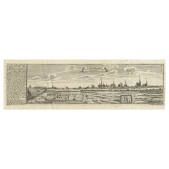
Items Similar to Maritime Majesty: The 17th-Century Skyline of Kalmar in Sweden, 1693

Want more images or videos?
Request additional images or videos from the seller
1 of 9
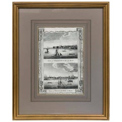
Maritime Majesty: The 17th-Century Skyline of Kalmar in Sweden, 1693
$432.36
$540.4520% Off
£320.27
£400.3320% Off
€360
€45020% Off
CA$591.58
CA$739.4720% Off
A$643.68
A$804.6020% Off
CHF 340.82
CHF 426.0320% Off
MX$7,743.91
MX$9,679.8820% Off
NOK 4,327.66
NOK 5,409.5820% Off
SEK 3,959.51
SEK 4,949.3820% Off
DKK 2,743.49
DKK 3,429.3720% Off
About the Item
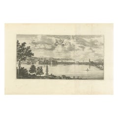
The engraving depicts the city of Kalmar, a historically significant city on the east coast of Sweden. This panoramic view captures the bustling port and the city's skyline during the late 17th to early 18th century. It's part of "Suecia Antiqua et Hodierna," a work by Erik Dahlberg, which translates to "Ancient and Modern Sweden." This ambitious work aimed to document Swedish architecture, landscapes, and towns, and was a major project of national interest at the time.
The image shows a variety of sailing vessels, indicative of Kalmar's importance as a maritime center. In the foreground, you can see the fortress of Kalmarsund, which would have been key to the city's defenses. The cityscape is rendered with fine detail, showing church spires, the characteristic rooftops of the period, and other architectural features that would have been prominent in Kalmar.
Kalmar itself is a city with a rich history, being the location where the Kalmar Union was signed in 1397, uniting Denmark, Norway, and Sweden under a single monarch. The city was also an important site for trade and military activities due to its strategic location.
Today, Kalmar is known for its well-preserved historical buildings, including Kalmar Castle, which dates back to the 12th century and was a key defensive structure throughout Sweden's history. The city has maintained much of its historical charm, with many of its older buildings and streetscapes carefully preserved, allowing visitors to get a sense of its historical significance. However, it has also evolved, with modern amenities and a vibrant cultural scene.
The engraving serves not only as a beautiful representation of Kalmar's historical vista but also as a document reflecting the city's importance during the period of its creation. For those interested in the history of Swedish cities and their development, Kalmar provides an excellent case study of the blend of historical preservation and contemporary evolution.
- Dimensions:Height: 13.08 in (33.2 cm)Width: 20.08 in (51 cm)Depth: 0 in (0.02 mm)
- Materials and Techniques:
- Period:1690-1699
- Date of Manufacture:1693
- Condition:Good. Minor soiling. Very clean overall, especially considering its age. Two plates joined with the vertical line visible. Please study the images carefully.
- Seller Location:Langweer, NL
- Reference Number:Seller: Bg-13670-231stDibs: LU3054338100362
About the Seller
5.0
Recognized Seller
These prestigious sellers are industry leaders and represent the highest echelon for item quality and design.
Platinum Seller
Premium sellers with a 4.7+ rating and 24-hour response times
Established in 2009
1stDibs seller since 2017
2,816 sales on 1stDibs
Typical response time: 1 hour
- ShippingRetrieving quote...Shipping from: Langweer, Netherlands
- Return Policy
More From This Seller
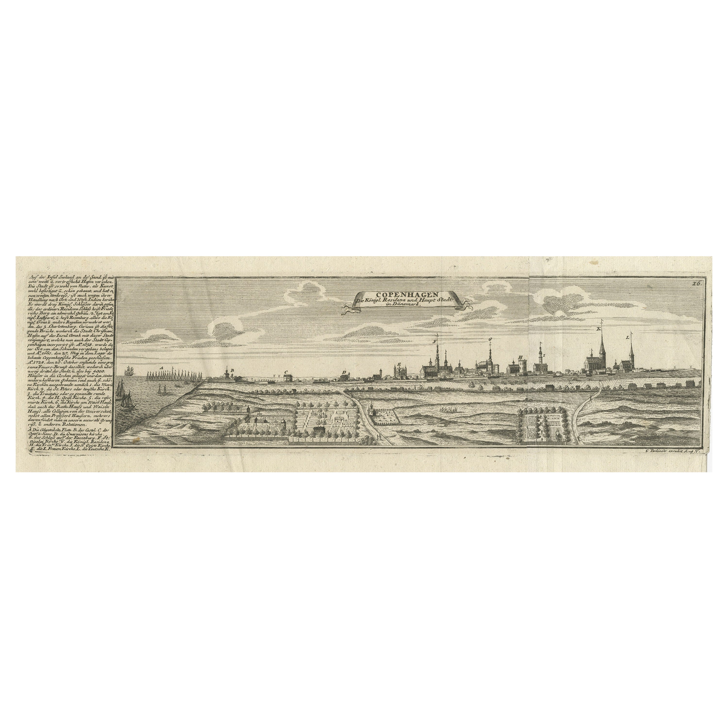
View AllRare Antique Engraving of the City of Copenhagen, Denmark, ca.1720
Located in Langweer, NL
Antique print titled 'Copenhagen. Die Königl. Residenz und Haupt Stadt in Dänemark'. Panoramic view of the city of Copenhagen, Denmark. This print, most likely, originates from the s...
Category
Antique 18th Century Prints
Materials
Paper
$441 Sale Price
20% Off
Prince Henry
s Naval and Land Battle during the Seven Years
War Engraved, 1667
Located in Langweer, NL
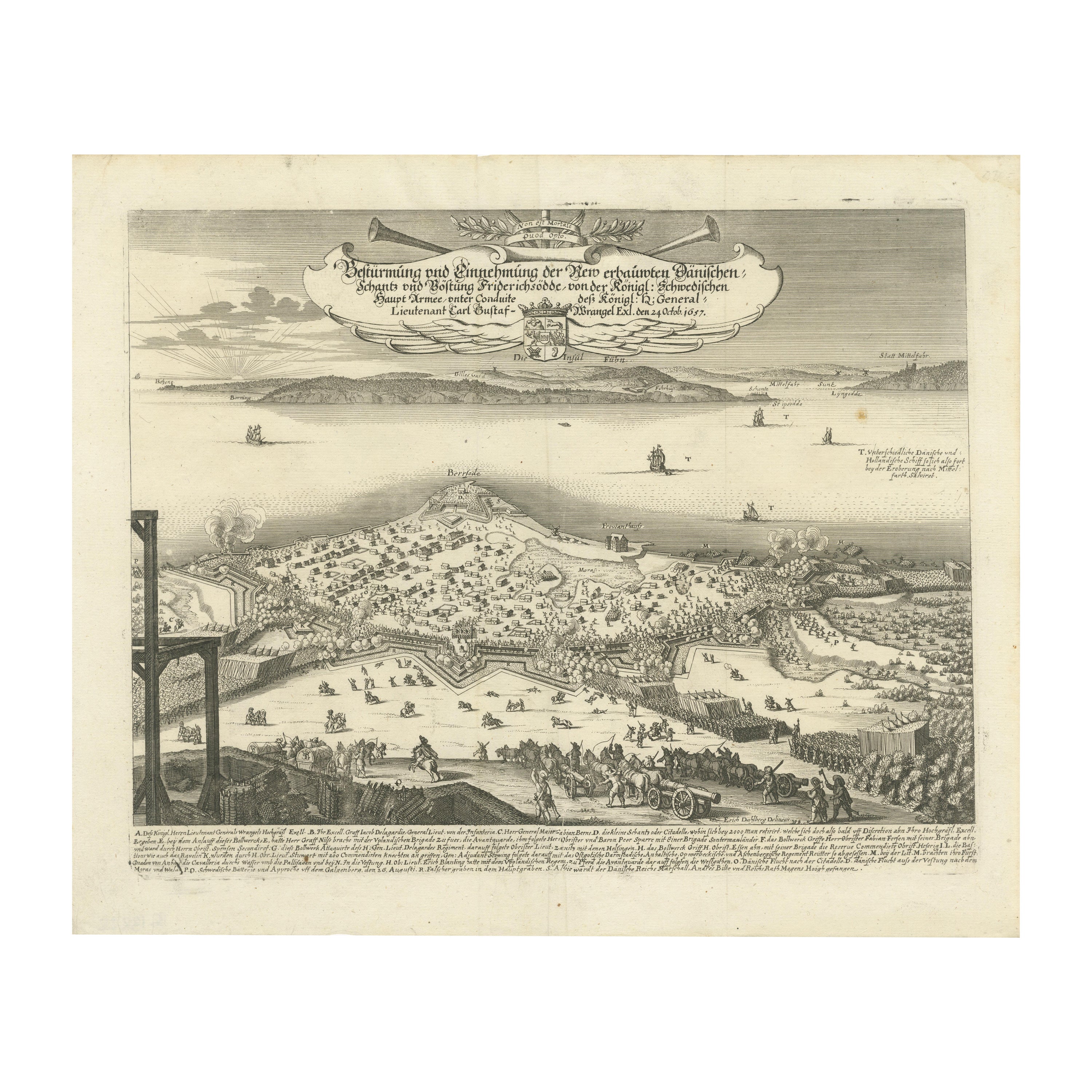
The engraving depicts the assault and capture of the Danish fortress Friderichsodde (now known as Fredericia) located on the island of Fyn. The scene, captured on October 24, 1657, vividly illustrates the Swedish main army's takeover under the command of General Carl Gustaf Wrangel. This historical event is meticulously documented in the artwork, which showcases not only the military action but also the strategic landscape and fortifications characteristic of the time.
Erik Jönsson Graf von Dahlberg, the artist behind this work, was a prominent Swedish field marshal, architect, and fortress builder. Born in 1625 and passing in 1703, Dahlberg's contributions to military and architectural fields were significant. He was renowned for his detailed and artistically valuable drawings which served as the basis for large-scale copperplate engravings. These engravings are of substantial topographical and architectural historical importance as they provide a detailed visual account of Swedish territories during the era.
In 1661, Dahlberg began work on his magnum opus—a comprehensive geographical and historical depiction of Swedish territories, which received royal privileges. His journey in 1667-1668 to Paris for the engraving of the initial plates reflects the international scope and ambition of his project. However, the work was intermittently paused when Dahlberg was tasked in 1674 with overseeing all Swedish fortress constructions, a role that significantly impacted his career and works. The project resumed and was published in 1684, highlighting a significant period of Swedish history and military achievements under his visual documentation.
MORE ABOUT THE BATTLE:
The image is an intricate engraving depicting a battle scene. Based on the details and the text in the cartouche, the scene illustrates a significant historical battle involving Prussian forces. The presence of multiple ships and extensive fortifications suggests a combined land and naval engagement.
Key Features in the Engraving:
1. Land Battle: The forefront of the image shows numerous troops, artillery pieces, and cavalry in action, depicting the intensity and scale of the land combat.
2. Naval Elements: Ships in the background indicate that this battle had a naval component, which would have been crucial for controlling trade routes or strategic waterways.
3. Fortifications: Extensive fortifications, including bastions and protective walls, suggest a well-defended location, possibly a city or a significant stronghold.
Historical Context:
From the text, it appears the battle involves "Prinz Heinrich," referring to Prince Henry of Prussia, who was an influential military leader during the reign of his brother, Frederick the Great. Under Frederick’s rule, Prussia engaged in several key conflicts, including the Seven Years' War (1756-1763), which saw major battles across Europe and involved complex alliances.
Given the level of detail and the era suggested by the style of ships and fortifications, the battle was of the significant engagements during the Seven Years' War, where Prince Henry played a critical role. His campaigns often involved maneuvering to protect Prussia from multiple fronts, including naval engagements in the Baltic.
Interpretation:
This engraving serves not only as a historical document but also as a piece of propaganda, likely glorifying the prowess and strategic capabilities of the Prussian military...
Category
Antique 1670s Prints
Materials
Paper
$441 Sale Price
20% Off
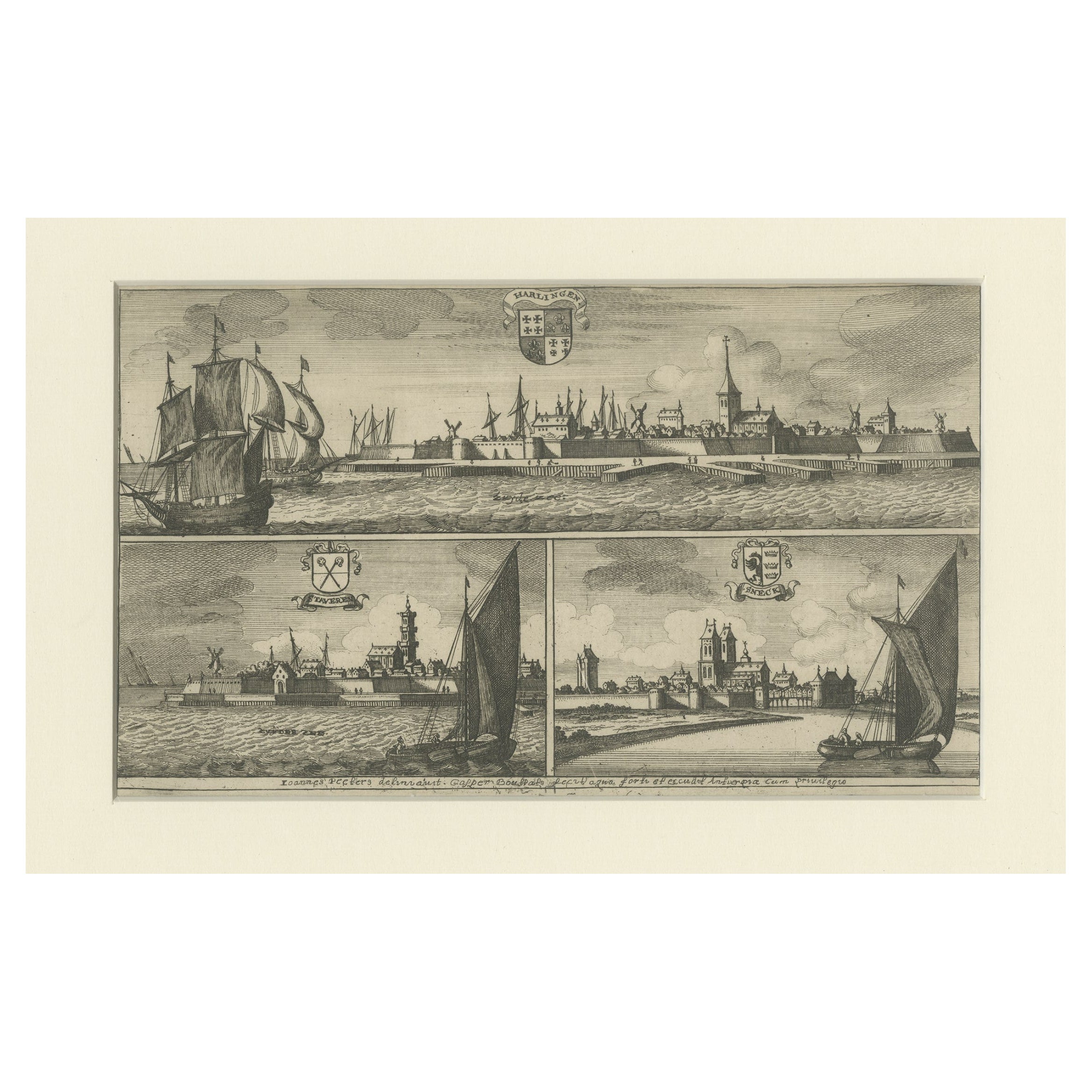
Engravings of Harlingen, Stavoren and Sneek in Friesland, the Netherlands, 1680
Located in Langweer, NL
Antique print titled 'Harlingen, Staveren, Sneck'. Views of the cities of Harlingen, Stavoren and Sneek, Friesland, the Netherlands. This print originates from 'Thooneel der Steden e...
Category
Antique 17th Century Prints
Materials
Paper
Antique Engraving of Königsberg from Suecia Antiqua et Hodierna, c.1690
Located in Langweer, NL
Antique Engraving of Königsberg from *Suecia Antiqua et Hodierna*, c.1690
Original 17th-century engraving from the celebrated work Suecia Antiqua et Hodierna, directed by the Swedis...
Category
Antique Late 17th Century Swedish Prints
Materials
Paper
Antique Print of Amboina by Van der Aa, circa 1725
By Pieter Van Der Aa
Located in Langweer, NL
Antique print titled 'Ville d'Amboine, capitale des Iles Molucques.' This view shows Amboina, the capital of the Molucca Islands, Indonesia. In the foreground several VOC and local s...
Category
Antique Mid-18th Century Prints
Materials
Paper
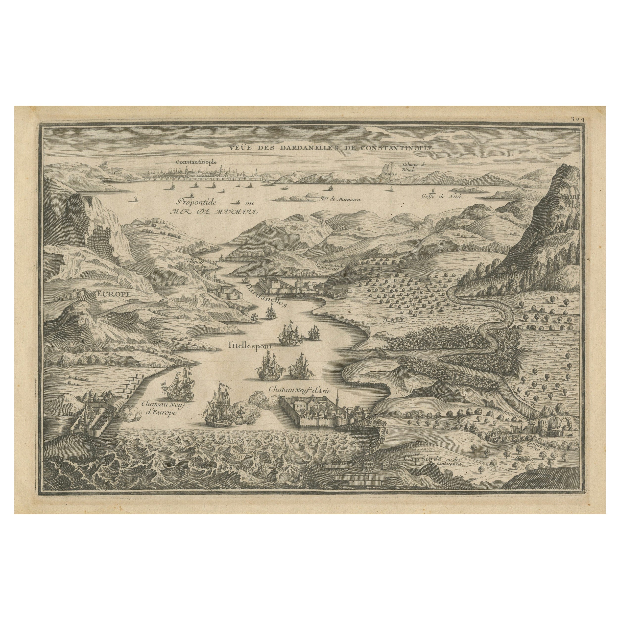
Dardanelles Strait, with a Perspective of the City of Constantinople, 1693
Located in Langweer, NL
Title: "Veue des Dardanelles de Constantinople, 1693"
Description: This historical copper engraving, crafted by Nicholas de Fer between 1646 and 1720 in Paris, is a remarkable depic...
Category
Antique 1690s Prints
Materials
Paper

$326 Sale Price
20% Off
You May Also Like
19th Century Reprint of 16th Century Harbor Map of Copenhagen
Located in Haddonfield, NJ
This reprint of 1587 antique map of Copenhagen, Denmark retains its original mid-century mat and has been recently reframed in classic wood frame. The muted sepia colored map is a wo...
Category
Antique 1880s Danish Baroque Maps
Materials
Wood, Paper

Lithograph View on Nieuw Amsterdam J . Vingboons 1660s
Located in Den Haag, NL
Afther a gouache by J Vingboons 1660s Beautiful Lithograph from 1910/20
Nieuw Amsterdam ofte nue nieuw Lorx opt Teyland Man .
Very nice fresh colors . Comes with a old label on the...
Category
Antique 1650s Dutch American Colonial Prints
Materials
Paper
Early 18th Century Engraving of the Northern Whale Fishery, circa 1720
Located in Nantucket, MA
Very early 18th century Dutch woodblock engraving of the Northern Whale Fishery, circa 1720, a hand colored engraving illustrating the Dutch whaling flee...
Category
Antique 1720s Dutch Baroque Prints
Materials
Paper
Framed Print, English Harbor Views, Early 19th Century
Located in Chappaqua, NY
Framed print of English Harbor views, early 19th century, "View of Greenwich in Kent and View of Deptford in Kent." Custom frame and mat.
Category
Antique Early 19th Century English Prints
Materials
Paper
A View of Cape Rouge, Quebec, Canada, Mazell after Capt. Hervey Smyth, c.1760s
Located in Savannah, GA
A View of Cape Rouge, or Carouge, on the Saint Lawrence River, north of Quebec.
Engraving by Peter Mazell after a drawing by Captian Hervey Smyth, published c.1760's, London.
T...
Category
Antique 1760s Canadian British Colonial Prints
Materials
Paper
Antique Voc Print Holland Malaysia Old Map Melaka History, 1663
Located in Amsterdam, Noord Holland
From my own collection I offer this impressive Antique print of the city of Malakka
A very interesting piece for collectors . It is an museum piece from the Dutch Institute of Orien...
Category
Antique 17th Century European Paintings
Materials
Paper

$293 Sale Price
20% Off
More Ways To Browse
White Cockatoo
White Elephant Sculpture
White Lacquer Asian
White Marble Top Commode
White Queen Anne
White Tara
Wide Chest Drawers
Wood And Painted Elephant
Wood Caryatids
Wood Skeleton Skeleton
Wooden Monkeys
Yukimi Lanterns
16th Century Tudor
17th Century Pearl
18th Century Russian Icon
1920s Wicker Furniture
1968 Desk
1970s Mirrored Bar