Want more images or videos?
Request additional images or videos from the seller
1 of 5
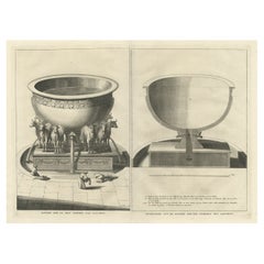
Original Antique Plan of the Temple of Solomon, Jerusalem, Israel, 1725
Price:$297.19
$404.17List Price
About the Item
- Dimensions:Height: 15.56 in (39.5 cm)Width: 19.1 in (48.5 cm)Depth: 0 in (0.02 mm)
- Materials and Techniques:
- Period:1720-1729
- Date of Manufacture:1725
- Condition:Wear consistent with age and use. Condition: Very good, please study image carefully.
- Seller Location:Langweer, NL
- Reference Number:Seller: BGI-00865 1stDibs: LU3054327047602
About the Seller
5.0
Recognized Seller
These prestigious sellers are industry leaders and represent the highest echelon for item quality and design.
Platinum Seller
Premium sellers with a 4.7+ rating and 24-hour response times
Established in 2009
1stDibs seller since 2017
2,828 sales on 1stDibs
Typical response time: 1 hour
Authenticity Guarantee
In the unlikely event there’s an issue with an item’s authenticity, contact us within 1 year for a full refund. DetailsMoney-Back Guarantee
If your item is not as described, is damaged in transit, or does not arrive, contact us within 7 days for a full refund. Details24-Hour Cancellation
You have a 24-hour grace period in which to reconsider your purchase, with no questions asked.Vetted Professional Sellers
Our world-class sellers must adhere to strict standards for service and quality, maintaining the integrity of our listings.Price-Match Guarantee
If you find that a seller listed the same item for a lower price elsewhere, we’ll match it.Trusted Global Delivery
Our best-in-class carrier network provides specialized shipping options worldwide, including custom delivery.You May Also Like
Original Antique Map of The World by Thomas Clerk, 1817
Located in St Annes, Lancashire
Great map of The Eastern and Western Hemispheres
On 2 sheets
Copper-plate engraving
Drawn and engraved by Thomas Clerk, Edinburgh.
Published by Mackenzie And Dent, 1817
...
Category
Antique 1810s English Maps
Materials
Paper

$90 / set
Free Shipping
H 10.25 in W 8.25 in D 0.07 in
Original Antique Map of Europe, Arrowsmith, 1820
Located in St Annes, Lancashire
Great map of Europe
Drawn under the direction of Arrowsmith.
Copper-plate engraving.
Published by Longman, Hurst, Rees, Orme and Brown, 1820
...
Category
Antique 1820s English Maps
Materials
Paper

Original Antique Map of Hungary, Arrowsmith, 1820
Located in St Annes, Lancashire
Great map of Hungary
Drawn under the direction of Arrowsmith.
Copper-plate engraving.
Published by Longman, Hurst, Rees, Orme and Brown, 1820
Unframed.
Category
Antique 1820s English Maps
Materials
Paper

Original Antique Map of Ireland- Kerry. C.1840
Located in St Annes, Lancashire
Great map of Kerry
Steel engraving
Drawn under the direction of A.Adlard
Published by How and Parsons, C.1840
Unframed.
Category
Antique 1840s English Maps
Materials
Paper

Original Antique Map of China, Arrowsmith, 1820
Located in St Annes, Lancashire
Great map of China
Drawn under the direction of Arrowsmith
Copper-plate engraving
Published by Longman, Hurst, Rees, Orme and Brown, 1820
Unfr...
Category
Antique 1820s English Maps
Materials
Paper

Original Antique Map of South America. C.1780
Located in St Annes, Lancashire
Great map of South America
Copper-plate engraving
Published C.1780
Two small worm holes to left side of map
Unframed.
Category
Antique Early 1800s English Georgian Maps
Materials
Paper

Original Antique Map of South Africa, Arrowsmith, 1820
Located in St Annes, Lancashire
Great map of South Africa.
Drawn under the direction of Arrowsmith.
Copper-plate engraving.
Published by Longman, Hurst, Rees, Orme and Br...
Category
Antique 1820s English Maps
Materials
Paper

Original Antique Print of Relics of Bonnie Prince Charlie. C.1880
Located in St Annes, Lancashire
Great image of relics belonging to Charles Edward Stuart, Bonnie Prince Charlie
Fine steel engraving by Charles Lawrie
Published by Blackie, Ed...
Category
Antique 1880s English Prints
Materials
Paper
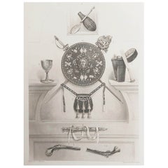
$35
Free Shipping
H 12 in W 8.25 in D 0.07 in
Catalogue of Engraved Views, Plans, Etc., Of New York City, 1st Ed
Located in valatie, NY
A catalogue of engraved views, plans, etc., Of New York City, (The Collection of Percy R. Pyne II). Privately Printed by The De Vinne Press, New York, 1912. Limited to 100 copies. Gr...
Category
Early 20th Century American Books
Materials
Paper

Original Antique Map of Ancient Greece, Achaia, Corinth, 1786
Located in St Annes, Lancashire
Great map of Ancient Greece. Showing the region of Thessaly, including Mount Olympus
Drawn by J.D. Barbie Du Bocage
Copper plate engraving by P.F Tardieu
Original hand color...
Category
Antique 1780s French Other Maps
Materials
Paper

$35
Free Shipping
H 10 in W 14 in D 0.07 in
More From This Seller
View AllAntique Engraving of the Brass Laver in Solomon
s Temple, Jerusalem, ca.1725
Located in Langweer, NL
Antique religion print titled 'Het kopere Waschvat, Tusschen de Tente der t'zamenkomst en den altaar'.
Antique print of the Brass Laver in Solomon's Tem...
Category
Antique 1720s Prints
Materials
Paper
$228 Sale Price
20% Off
Antique Engraving of One of the Ten Brass Lavers in Solomon
s Temple, 1725
Located in Langweer, NL
Antique religion print titled 'Een der tien Kopere Waschvaten in den Tempel van Salomon'.
This print depicts one of the ten Brass Lavers in Solomon's Temple. This print originate...
Category
Antique 1720s French Prints
Materials
Paper
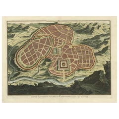
Antique Map of Ancient Jerusalem, depicting The Temple of Solomon, c.1725
Located in Langweer, NL
Antique map titled 'Nieuwe Plattegrond van het Oude Jeruzalem Volgens den Schryver.'
Bird's-eye view of the ancient city of Jerusalem shows its divisions with prominent depictions ...
Category
Antique 18th Century French Maps
Materials
Paper
The
Brazen Sea
in Solomon
s Temple and a Cross Section of the Brazen Sea, 1725
Located in Langweer, NL
Two religious images on one sheet titled 'Kopere Zee in den Tempel van Salomon' and 'Doorsnede van de Kopere Zee des Tempels van Salomon'.
The 'Brazen Sea' in Solomon's Temple an...
Category
Antique 1720s Dutch Prints
Materials
Paper
Spectacular Antique Original Engraving of a Town Plan of Jerusalem, 1708
Located in Langweer, NL
Description: Antique map titled 'Erster Abriss der Stadt Jerusalem wie sie Furnemblich zur Zeit des Hernn Christi beschaffen (..).'
Spectacular town plan...
Category
Antique Early 1700s Maps
Materials
Paper

Antique Bible Plan of Ancient Jerusalem, 1743
Located in Langweer, NL
This plan originates from ‘Biblia Sacra, dat is, de H. Schriftuer van het Oude, en het Nieuwe Testament, naer de laetste Roomsche keure der gemeine Latijnsche overzettinge, in nederd...
Category
Antique Mid-18th Century Maps
Materials
Paper

$819 Sale Price
37% Off
Still Thinking About These?
All Recently ViewedMore Ways To Browse
Shepard Fairey 2001
Sonny Zoback
Stained Glass Fairy
Superstudio Lithograph
Tretchikoff Vintage Prints
Trowbridge Gallery Print
Victor Ostrovsky
Vintage Maio Prints
Vintage Puppet Theater
Volkamer Prints
W Dendy Sadler
Werner Graeff
Woodblock Crow
Woodville Prints
Empire Library
Flame Maple
Flower Vanity
Folk Art Rabbit