Items Similar to Original Antique Street Plan of Peking, Beijing, China

Want more images or videos?
Request additional images or videos from the seller
1 of 6
Original Antique Street Plan of Peking, Beijing, China
$557.68
$697.1020% Off
£413.09
£516.3720% Off
€464
€58020% Off
CA$762.89
CA$953.6120% Off
A$831.51
A$1,039.3920% Off
CHF 439.61
CHF 549.5220% Off
MX$10,009.81
MX$12,512.2620% Off
NOK 5,579.77
NOK 6,974.7220% Off
SEK 5,115.51
SEK 6,394.3920% Off
DKK 3,535.42
DKK 4,419.2820% Off
About the Item
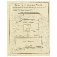
Antique print titled 'Plan topographique de Péking'. Plan of the city of Beijing, Peking, China. Published by Formentin
Cie, circa 1830.
- Dimensions:Height: 10.52 in (26.7 cm)Width: 9.06 in (23 cm)Depth: 0.02 in (0.5 mm)
- Materials and Techniques:
- Period:
- Date of Manufacture:circa 1830
- Condition:Age-related toning. Some wear and soiling, blank verso. Please study image carefully.
- Seller Location:Langweer, NL
- Reference Number:Seller: BG-13379-311stDibs: LU3054333407602
About the Seller
5.0
Recognized Seller
These prestigious sellers are industry leaders and represent the highest echelon for item quality and design.
Platinum Seller
Premium sellers with a 4.7+ rating and 24-hour response times
Established in 2009
1stDibs seller since 2017
2,813 sales on 1stDibs
Typical response time: 1 hour
- ShippingRetrieving quote...Shipping from: Langweer, Netherlands
- Return Policy
More From This Seller
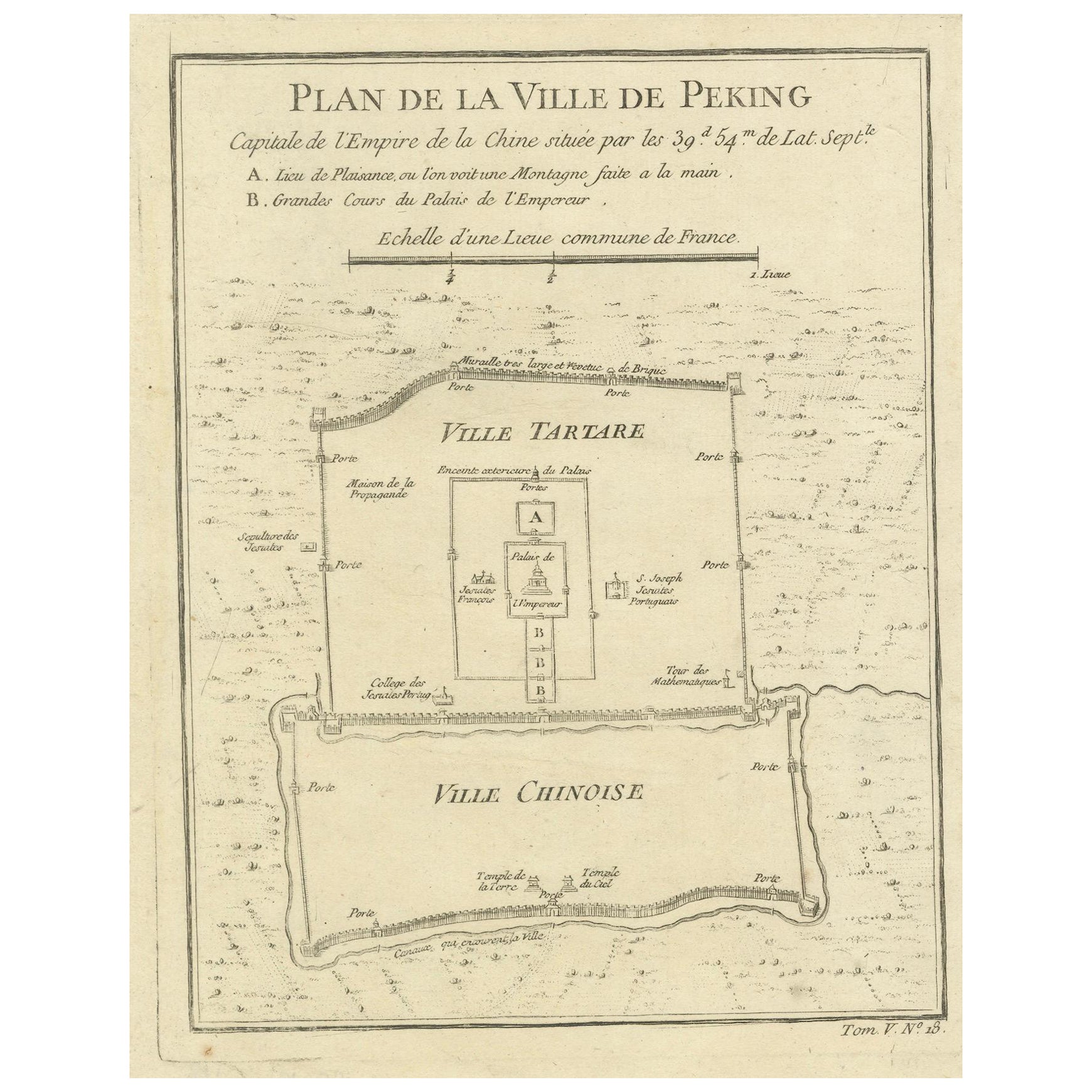
View AllBeijing (Peking) Map with Tartar and Chinese Divisions
Jesuit Missions, 1754
Located in Langweer, NL
An antique map by Jacques Nicolas Bellin titled "Plan de la Ville de Peking Capitale de l'Empire de la Chine," published in Paris in 1754.
This finely engraved plan shows the detailed layout of the city of Peking (now known as Beijing), the capital of China. The map distinctly divides the city into the "Ville Tartare" (Tartar City) and "Ville Chinoise" (Chinese City), indicating the segregated living areas during that period. Notable features on the map include the Emperor's Palace and the French Jesuit and Portuguese Jesuit missions located in the Tartar City, as well as the Temples of the Earth and Sky marked in the Chinese City.
This kind of map is a valuable historical document, offering insight into the urban planning and social geography of Beijing in the mid-18th century. It reflects the European interest in the far reaches of the world during the age of exploration...
Category
Antique 1750s French Prints
Materials
Paper
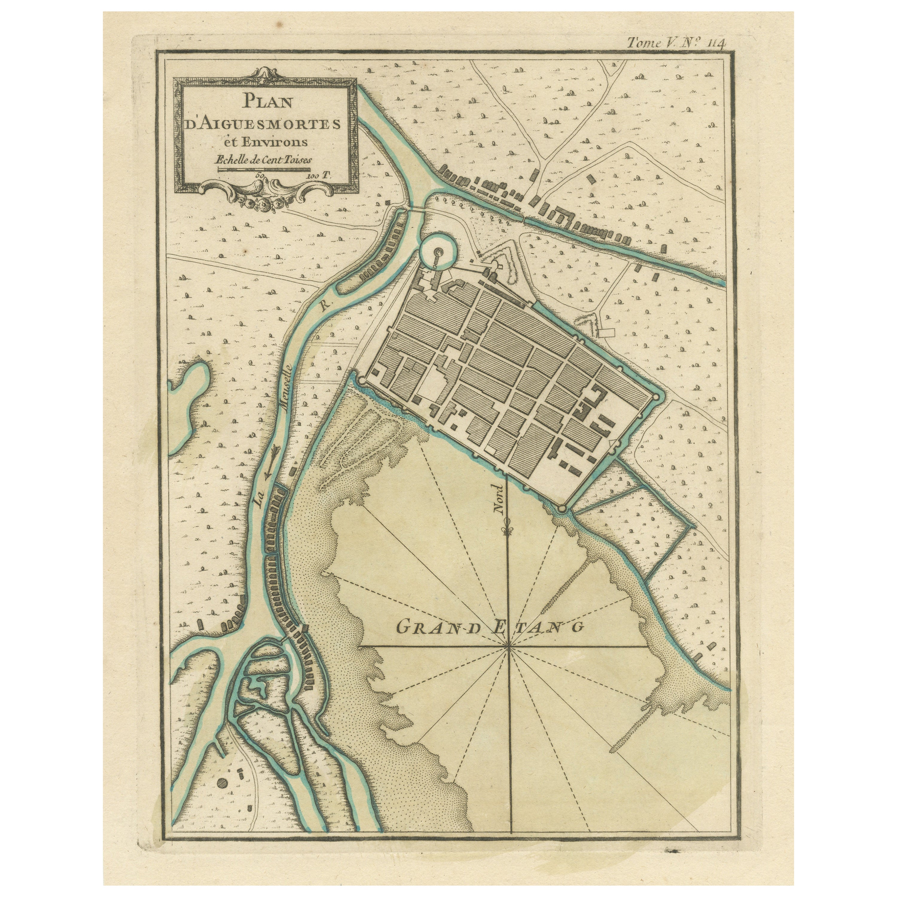
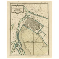
Antique Plan of Aigues-Mortes, France
Located in Langweer, NL
Antique map titled 'Plan d'Aiguesmortes et environs'. Original plan of the region of Aigues-Mortes, France. This map originates from 'Le Petit Atlas Maritime (..)' by J.N. Bellin. Pu...
Category
Antique Mid-18th Century Maps
Materials
Paper
$326 Sale Price
20% Off
Antique Map of Batavia, Nowadays Jakarta, the Capital of Indonesia, 1782
Located in Langweer, NL
Antique map Batavia titled 'Batavia zo als het was in den Jaare 1731'. Old map of the city of Batavia (Jakarta) in Indonesia. Originates from 'Batavia, de Hoofdstad van Neerlands O. ...
Category
Antique 18th Century Maps
Materials
Paper
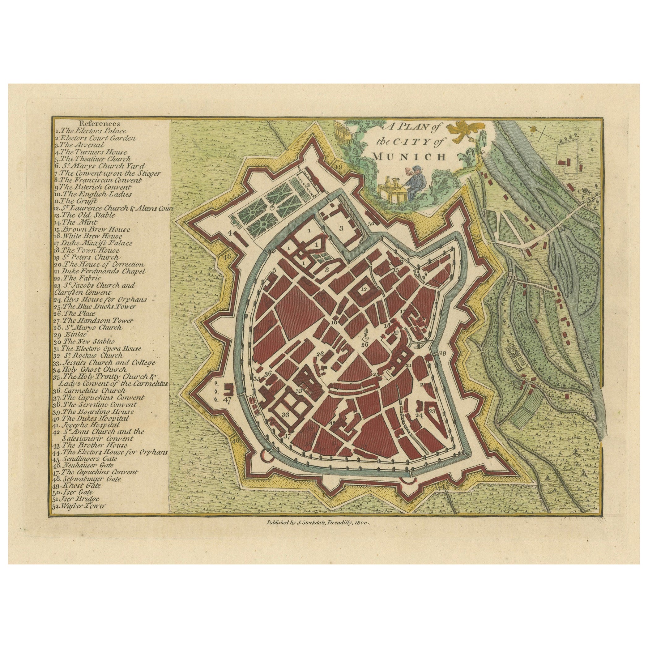
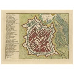
Original Antique Map of Munich, Germany by J. Stockdale, 1800
Located in Langweer, NL
Title: Vintage Map of Munich, Germany by J. Stockdale, 1800
This vintage map, titled "A Plan of the City of Munich," was published by J. Stockdale in Piccadilly, London, in 1800. Th...
Category
Antique Early 1800s Maps
Materials
Paper
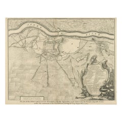
Antique Plan of the Fortifications of Lleida, Spain
Located in Langweer, NL
Antique print titled 'Plan of the Town and Castle of Lerida, with the Approaches Made Before It by the French & Spanish Armies Under the Command of the D. of Orleans During the Siege...
Category
Antique Mid-18th Century Prints
Materials
Paper
$423 Sale Price
20% Off
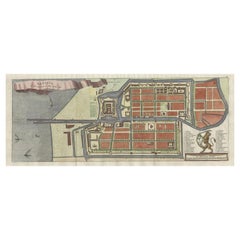
Antique Map of the City of Berlin in Germany,
1847
Located in Langweer, NL
Antique map titled 'Berlin'. Original antique map of the city of Berlin, Germany. This map originates from 'Abrégé de Géographie (..)' by Adrien Balbi. Published 1847.
Category
Antique Mid-19th Century Maps
Materials
Paper

$144 Sale Price
20% Off
You May Also Like
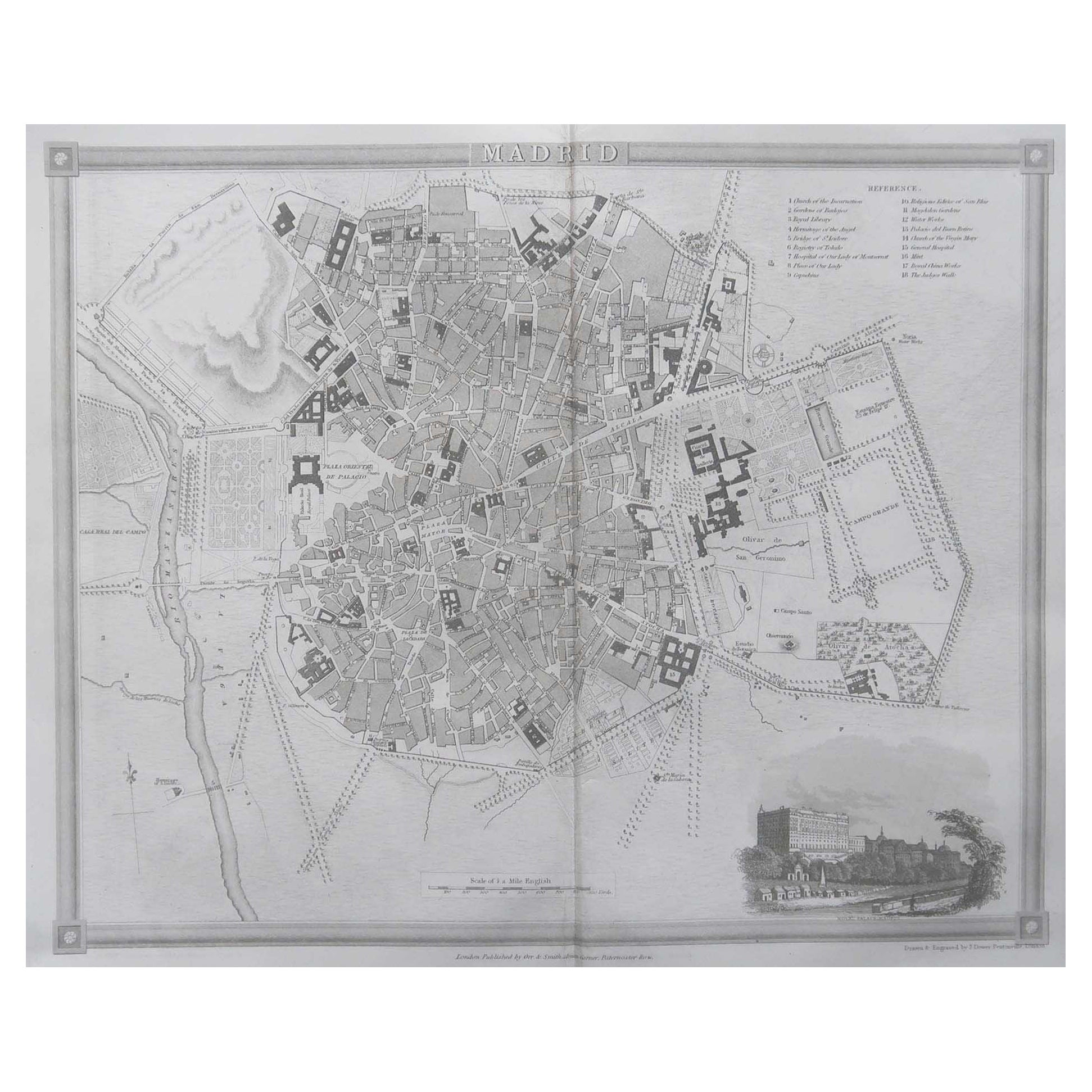
Original Antique Map or City Plan of Madrid, Spain. Circa 1835
Located in St Annes, Lancashire
Nice map of Madrid
Drawn and engraved by J.Dower
Published by Orr & Smith. C.1835
Unframed.
Free shipping
Category
Antique 1830s English Maps
Materials
Paper

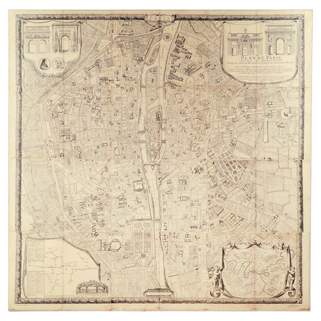
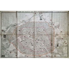
"Plan de Paris" - Antique Recreation of a Map of Paris
Located in New York, NY
Printed in the Early 20th Century, this antique "Plan de Paris" is a recreation of an earlier map from 1710, originally commissioned by Louis XIV. It was an intricately rendered view...
Category
Early 20th Century French Louis XIV Maps
Materials
Linen, Wood, Paper

Original Antique Map or City Plan of Geneva, Switzerland. Circa 1835
Located in St Annes, Lancashire
Nice map of Geneva
Drawn and engraved by J.Dower
Published by Orr & Smith. C.1835
Unframed.
Free shipping
Category
Antique 1830s English Maps
Materials
Paper

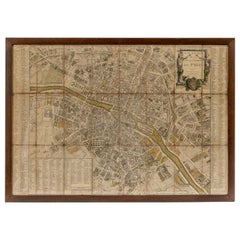
1848 Original map by Maillard - Plan de Paris et ses Fortifications
Located in PARIS, FR
In the realm of cartography, maps serve as both practical tools and artistic representations, encapsulating the essence of a place at a specific moment in time. The 1848 vintage map,...
Category
1840s Prints and Multiples
Materials
Paper, Lithograph, Linen
18th Century Map of Paris
Located in Washington, DC
18th century map of Paris.
Category
Antique Late 18th Century French Prints
Materials
Glass, Wood, Paper
1851 Original map by Maillard - Plan de Paris et ses Fortifications
Located in PARIS, FR
In the world of cartography, maps transcend mere geography; they are historical records and works of art, encapsulating the essence of a place at a specific moment in time. The 1851 ...
Category
1850s Prints and Multiples
Materials
Linen, Paper, Lithograph

More Ways To Browse
Glazed Horses Chinese
Gold Dragon Sculpture
Grain Painted Chest
Grete Jalk For Poul Jeppesen
Gustave Eiffel
Hand Carved Chinese Figures
Hans Wegner Rattan
Hermes Equestrian Silver
Horace Brown
Ice Cream Cone Vintage
Industrial Bin
Inuit Carving
Iran Brass
Iron Bull
Iron Cow
Ironies Furniture
Japanese Bronze Figure
Japanese Cat Art