1 of 7
PRINTS, AMERICA, AFRICA AND THE WEST INDIES, 1768, IN LONDON
$2,527List Price
About the Item
- Dimensions:Height: 16 in (40.64 cm)Width: 20 in (50.8 cm)
- Sold As:Set of 6
- Place of Origin:
- Period:
- Date of Manufacture:Circa 1768
- Condition:excellent antique conditions.
- Seller Location:New York, NY
- Reference Number:Seller: CT49/31stDibs: 0905048485162
Authenticity Guarantee
In the unlikely event there’s an issue with an item’s authenticity, contact us within 1 year for a full refund. DetailsMoney-Back Guarantee
If your item is not as described, is damaged in transit, or does not arrive, contact us within 7 days for a full refund. Details24-Hour Cancellation
You have a 24-hour grace period in which to reconsider your purchase, with no questions asked.Vetted Professional Sellers
Our world-class sellers must adhere to strict standards for service and quality, maintaining the integrity of our listings.Price-Match Guarantee
If you find that a seller listed the same item for a lower price elsewhere, we’ll match it.Trusted Global Delivery
Our best-in-class carrier network provides specialized shipping options worldwide, including custom delivery.You May Also Like
Antique Map of South American, The West Indies
Most of Africa, Ca.1775
Located in Langweer, NL
Antique map titled 'Carte pour Servir a l' Histoire Philosophique et Politique des Etablissemens et du Commerce des Europeens dans les deux Indes'.
This map is roughly centered o...
Category
Antique 1770s Maps
Materials
Paper

$721 Sale Price
20% Off
H 15.04 in W 19.77 in D 0 in
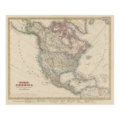
Antique Map of North America Including the West Indies
Located in Langweer, NL
Original antique map titled 'Nord-America'. Old map of North America and the West Indies. Also showing British Overseas Territories and Hudson Bay.
This map originates from Stiel...
Category
Antique Mid-19th Century German Maps
Materials
Paper
$516 Sale Price
25% Off
H 14.65 in W 17.88 in D 0.02 in
Antique Map of the West Indies and Central America by Lowry
1852
Located in Langweer, NL
Antique map titled 'West Indies and Central America'. Original map of the West Indies and Central America. This map originates from 'Lowry's Table Atlas constructed and engraved from...
Category
Antique Mid-19th Century Maps
Materials
Paper

$94 Sale Price
20% Off
H 9.65 in W 12.21 in D 0.02 in
Antique Map of the West Indies and Central America by W. G. Blackie, 1859
Located in Langweer, NL
Antique map titled 'The West India Island & Central America'. Original antique map of the West Indies and Central America, with inset map of Jamaica. Th...
Category
Antique Mid-19th Century Maps
Materials
Paper

$237 Sale Price
20% Off
H 14.57 in W 21.26 in D 0.02 in
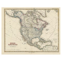
Antique Map with Hand Coloring of North America and the West Indies
Located in Langweer, NL
Original antique map titled 'Nord-America'. Old map of North America and the West Indies.
This map originates from Stielers Handatlas, published circa 1879. Stielers Handatlas (a...
Category
Antique Late 19th Century Maps
Materials
Paper
$551 Sale Price
25% Off
Free Shipping
H 15.08 in W 18.78 in D 0.02 in
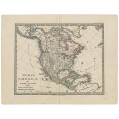
Antique Map of North America and the West Indies by Stieler, circa 1865
Located in Langweer, NL
Antique map titled 'Nord-America und West-Indien'. Old map of North America and the West Indies. This map originates from Stieler's 'Schul-Atlas'.
Category
Antique Mid-19th Century Maps
Materials
Paper
$142
H 9.45 in W 12.21 in D 0.02 in
Antique Map of the Americas and West Indies by Robert de Vaugondy, 1778
Located in Langweer, NL
Antique Map of the Americas and West Indies by Robert de Vaugondy, 1778
This detailed antique map titled "Amérique ou Indes Occidentales" was published in 1778 by the renowned Frenc...
Category
Antique Late 18th Century French Maps
Materials
Paper

$1,335 Sale Price
25% Off
H 20.87 in W 27.56 in D 0.02 in
Cricket Print, England v. West Indies at the Oval, by Arthur Weaver
By Arthur Weaver
Located in Oxfordshire, GB
1990's Arthur Weaver Oval Cricket Ground Print, England v West Indies.
A colourful cricket lithograph signed by the artist, Arthur Weaver, of the 'Final Test' at The Oval Cricket Gr...
Category
1990s English Sporting Art Sports Equipment and Memorabilia
Materials
Paper

$574
Free Shipping
H 25 in W 33.25 in D 0.1 in
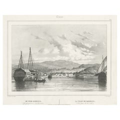
Antique Print of Kupang or Koepang in the East Indies, Now West-Timor, Indonesia
Located in Langweer, NL
Antique print Timor titled 'De Stad Koepang, La Ville de Koepang'. View of the town of Koepang / Concordia / Kupang on the Island of Timor, Indonesia. Originates from 'Gezigten uit Neerlands Indie, naar de natuur geteekend en beschreven.', by C.W.M. van de Velde, published in Amsterdam, Frans Buffa en Zonen (1844-1845).
Artists and Engravers: Charles William Meredith van de Velde (1818-1898) was a Dutch...
Category
Antique 19th Century Prints
Materials
Paper
$486
H 11.62 in W 15.56 in D 0 in
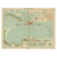
Antique Map of the West Indies in Full Color, 1922
Located in Langweer, NL
Antique map titled 'The West Indies.' A map of the West Indies, the Carribean region. This includes the Greater Antilles (Jamaica, Haiti, Puerto Rico and Cuba) and the Lesser Antille...
Category
20th Century Maps
Materials
Paper