Items Similar to Rare Antique Map of the Imperial Court in Peking China, 1665

Want more images or videos?
Request additional images or videos from the seller
1 of 10
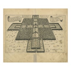
Rare Antique Map of the Imperial Court in Peking China, 1665
$538.53
£403.15
€450
CA$741.36
A$810.45
CHF 428.76
MX$9,698.30
NOK 5,455.39
SEK 4,993.86
DKK 3,428.45
About the Item
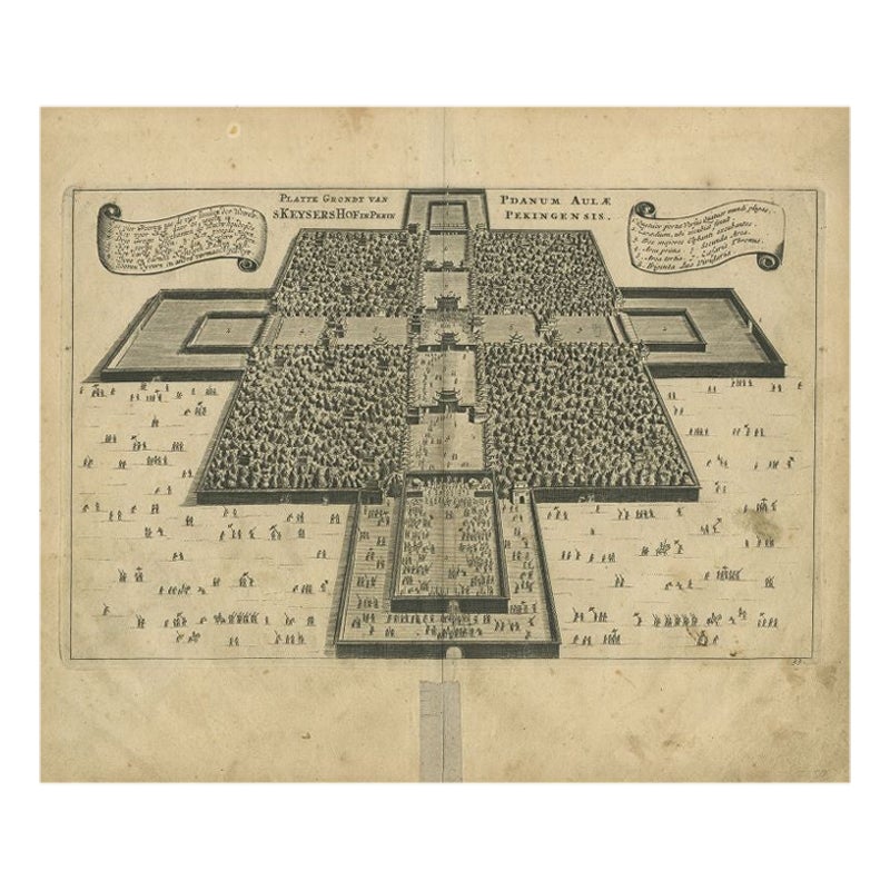
Antique print titled 'Platte Grondt van s Keysers Hof in Pekin. Forme de la Cour Imperiale de Peking'. This print originates from 'Joan Nieuhof, Het Gezandschap Der Neêrlandtsche Oost-Indische Compagnie, aan den grooten Tartarischen Cham.'
- Dimensions:Height: 12.01 in (30.5 cm)Width: 14.61 in (37.1 cm)Depth: 0.02 in (0.5 mm)
- Materials and Techniques:Paper,Engraved
- Place of Origin:
- Period:Mid-17th Century
- Date of Manufacture:1665
- Condition:Minor fading. Please study image carefully.
- Seller Location:Langweer, NL
- Reference Number:Seller: BGI-005641stDibs: LU305439929441
About the Seller
5.0
Recognized Seller
These prestigious sellers are industry leaders and represent the highest echelon for item quality and design.
Platinum Seller
Premium sellers with a 4.7+ rating and 24-hour response times
Established in 2009
1stDibs seller since 2017
2,793 sales on 1stDibs
Typical response time: <1 hour
- ShippingRetrieving quote...Shipping from: Langweer, Netherlands
- Return Policy
More From This Seller
View AllOriginal Antique Print of the Imperial Palace in Beijing, China, 1668
Located in Langweer, NL
Antique print titled 'Platte Grondt van s Keysers Hof in Pekin - Pdanum Aulae Penigensis'. Old print of the Imperial Palace in Beijing, China. Originates from Niehof's Latin edition ...
Category
Antique 17th Century Prints
Materials
Paper
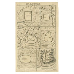
Antique Map of Cities of the Province of Shanxi in China, 1749
By Jacques-Nicolas Bellin
Located in Langweer, NL
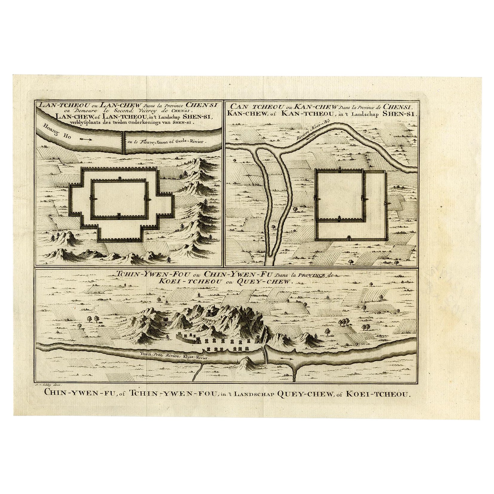
Antique print titled: 'Lan-Tcheou ou Lan-Chew dan la province Chensi; Can Tcheou ou Kan-Chew dan la province de Chensi; Tchin-Ywe-Fou ou Chin-Ywen-Fu dans la province de Koei-Tcheou ...
Category
Antique 18th Century Maps
Materials
Paper

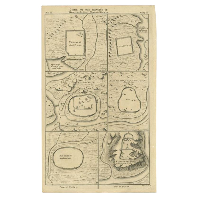
Antique Map of the Cities of the Qing Dynasty Provinces in China, 1738
Located in Langweer, NL
Antique print titled 'Cities of the Province of Kyang-si, Fo-kyen, Shan-Si & Yun-nan'. Old map depicting four walled cities of the Chinese Qing dynasty provinces Yunnan, Shanxi, Fuji...
Category
Antique 18th Century Maps
Materials
Paper
$248 Sale Price
20% Off
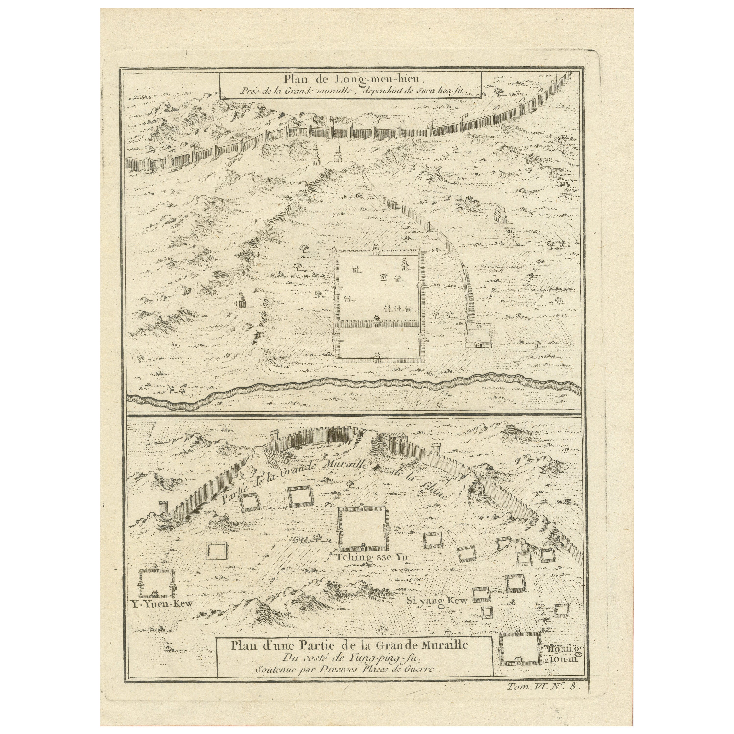
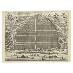
1749 Jacques Nicolas Bellin Map of the Great Wall of China Near Kiang-nan fu
Located in Langweer, NL
This original antique image is an historical map by Jacques Nicolas Bellin, depicting the Great Wall of China as it was understood in the mid-18th century.
The map includes French ...
Category
Antique 1750s Prints
Materials
Paper

$143 Sale Price
20% Off
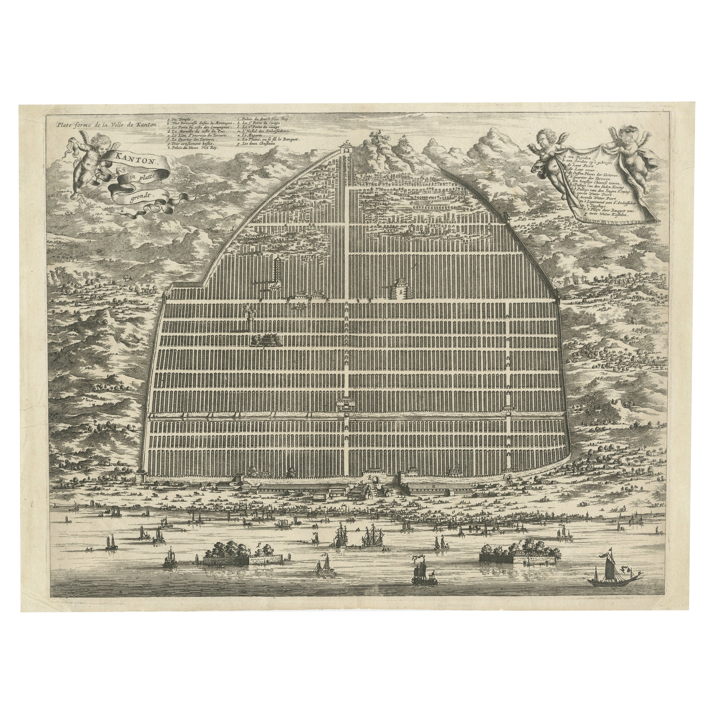
17th Century Cartographic Marvel: A Detailed Engraving of Guangzhou (Kanton)
Located in Langweer, NL
This engraving of Guangzhou ("Kanton") is from a French edition of Olfert Dapper's work. The French edition titled "Description de l’Empire de la Chine" was published in 1674. It is ...
Category
Antique 1670s Maps
Materials
Paper
$1,053 Sale Price
20% Off
Free Shipping
Antique Map of Three Chinese Cities in Chensi and Koei Tcheou, c.1758
Located in Langweer, NL
Antique map titled 'Lan-Tcheou ou Lan-Chew dan la province Chensi; Can Tcheou ou Kan-Chew dan la province de Chensi; Tchin-Ywe-Fou ou Chin-Ywen-Fu dans la province de Koei-Tcheou ou Quey-chew.' Three plans of old Chinese cities...
Category
Antique 18th Century Maps
Materials
Paper

You May Also Like
1627 Hendrik Hondius Map Entitled "Vltoniae Orientalis Pars, " Ric.a009
Located in Norton, MA
1627 Hendrik Hondius map entitled
"Vltoniae orientalis pars,"
Ric.a009
Title:
Vltoniae orientalis : pars
Title (alt.) :
Ultoniae orientalis pars
Creator:
Mercator, Gerh...
Category
Antique 17th Century Dutch Maps
Materials
Paper

1633 Map "La Souverainete De Sedan Et De Raucourt, Et La Prevoste Ric0011
Located in Norton, MA
1653 map entitled
"La Souverainete de Sedan et de Raucourt, et la Prevoste de Doncheri,"
Ric0011
Description:
Lovely map centered on Sedan and Doncheri and the Meuze River fr...
Category
Antique 17th Century Dutch Maps
Materials
Paper

Super Rare Antique French Map of Chine and the Chinese Empire, 1780
Located in Amsterdam, Noord Holland
Super Rare Antique French Map of Chine and the Chinese Empire, 1780
Very nice map of Asia. 1780 Made by Bonne.
Additional information:
Type: Map
...
Category
Antique 18th Century European Maps
Materials
Paper

$438 Sale Price
49% Off
Antique French Map of Asia Including China Indoneseia India, 1783
Located in Amsterdam, Noord Holland
Very nice map of Asia. 1783 Dedie au Roy.
Additional information:
Country of Manufacturing: Europe
Period: 18th century Qing (1661 - 1912)
Condition: Overall Condition B (Good Used)...
Category
Antique 18th Century European Maps
Materials
Paper

$486 Sale Price
40% Off
1635 Willem Blaeu Map of Northern France"Comitatvs Bellovacvm" Ric.a08
Located in Norton, MA
1635 Willem Blaeu map of northern France, entitled.
"Comitatvs Bellovacvm Vernacule Beavvais,"
Colored
Ric.a008
“COMITATVS BELLOVACVM…” Amsterdam: W...
Category
Antique 17th Century Unknown Maps
Materials
Paper

1640 Joan Bleau Map Entitled"Diocecese de rheims et le pais de rethel, " Eic.a011
Located in Norton, MA
1640 Joan Bleau map entitled
"Diocecese de rheims et le pais de rethel,"
Ric.a011
OAN BLAEU
Diocecese de Rheims, et le pais de Rethel.
Handcolored engraving, c.1640.
...
Category
Antique 17th Century Dutch Maps
Materials
Paper
