Items Similar to Sag Harbor Nautical Chart

Want more images or videos?
Request additional images or videos from the seller
1 of 12
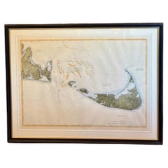
Sag Harbor Nautical Chart
$300
£228.54
€263.54
CA$424.96
A$456.30
CHF 245.53
MX$5,399.84
NOK 3,093.17
SEK 2,821.14
DKK 1,969.14
About the Item
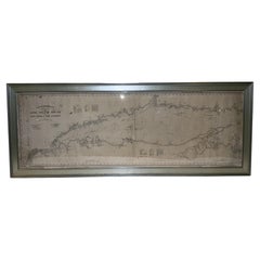
Marine chart of Greenport, Orient, and Sag Harbor New York published by George Eldridge in 1901. Details include the areas of Greenport, Orient, Shelter Island, Hog Neck, Sag Harbor, etc., dated 1901. Chart shows water depths, buoys, lighthouses, etc., This is from 1901. Nicely matted and framed.
Weight: 6 lbs.
Overall Dimensions: 26"H x 22"W
Made: America
Material: Paper
Date: 1901
- Dimensions:Height: 26 in (66.04 cm)Width: 22 in (55.88 cm)Depth: 1 in (2.54 cm)
- Materials and Techniques:
- Period:1900-1909
- Date of Manufacture:1901
- Condition:
- Seller Location:Norwell, MA
- Reference Number:Seller: 85521stDibs: LU1741238240992
About the Seller
5.0
Vetted Professional Seller
Every seller passes strict standards for authenticity and reliability
Established in 1967
1stDibs seller since 2015
440 sales on 1stDibs
Typical response time: 1 hour
- ShippingRetrieving quote...Shipping from: Norwell, MA
- Return Policy
More From This Seller
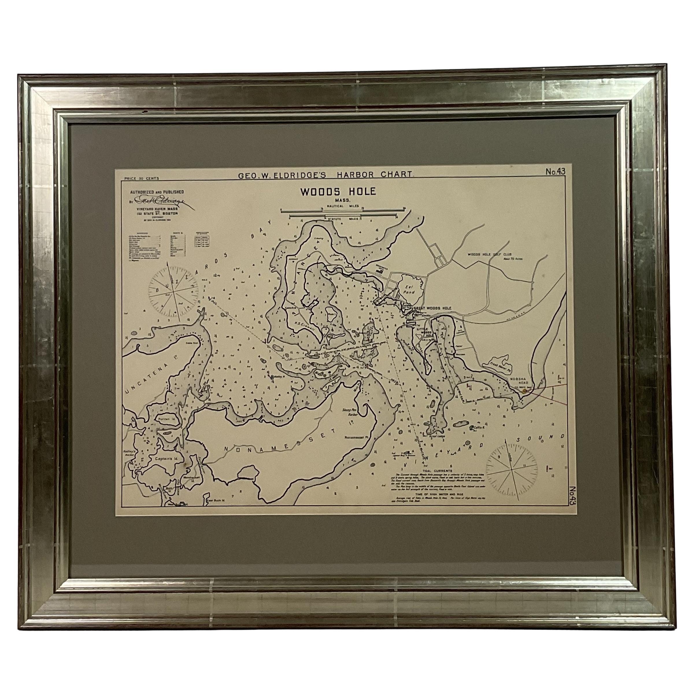
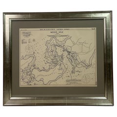
View All1901 Nautical Chart Showing Woods Hole, Mass
Located in Norwell, MA
Rare 1901 chart of Woods Hole, Mass., showing Buzzards Bay, Penzance Point, Nonamesset Island, Downtown Woods Hole, Parker Neck, Nobska Head, Vineyard Sound, Woods Hole Golf Club, Ra...
Category
Antique Early 1900s North American Maps
Materials
Paper
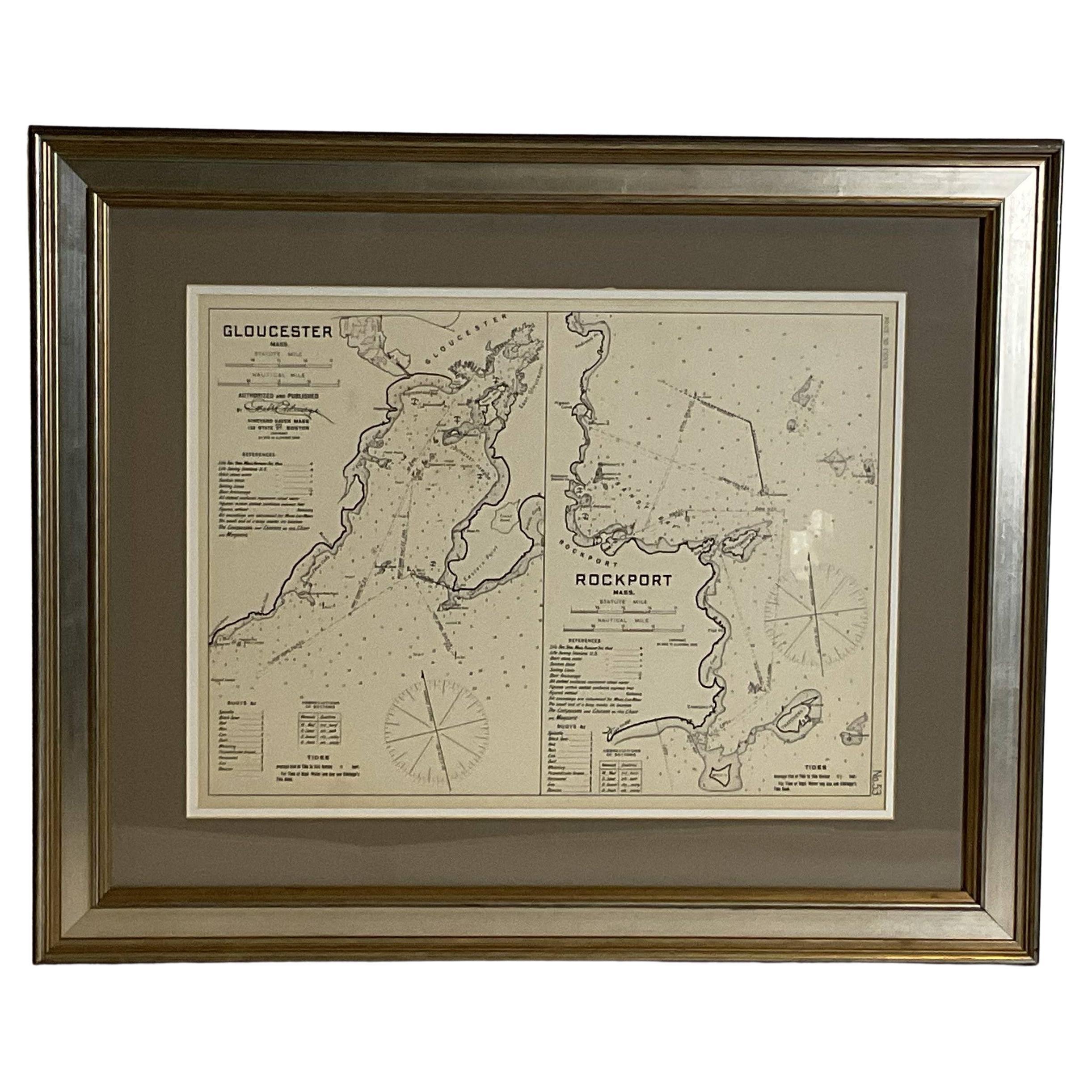
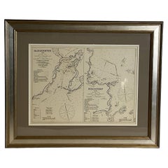
Mariners Chart of Gloucester and Rockport by George Eldridge 1910
Located in Norwell, MA
Nautical chart showing the harbor and local water. The chart display depths buoys, lighthouses, etc., This chart shows Eastern Point, Rocky Neck, Stage head, Thatcher Island, Sandy B...
Category
Vintage 1910s North American Prints
Materials
Paper
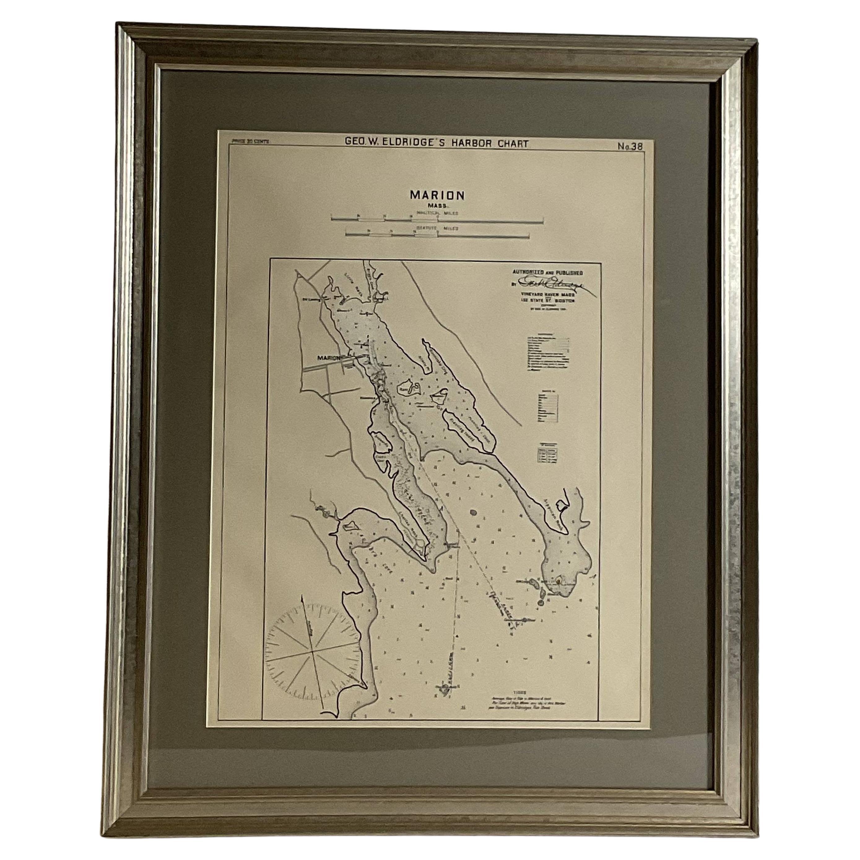
Mariners Chart of Marion Massachussets by George Eldridge 1901
Located in Norwell, MA
Nautical chart showing the harbor and local waters of Marion Harbor., The chart displays depth, buoys, lighthouses, etc., Shown are Planting Island, Ram Island, Sippican Neck, Little...
Category
Antique Early 1900s North American Prints
Materials
Paper

Copy of 1901 Chart of Boston Harbor
Located in Norwell, MA
Later copy after an original Boston Harbor chart by George Eldridge of Vineyard Haven and Boston. Detailed chart of Boston Harbor from the Neponset River in Quincy south down to Kimb...
Category
Vintage 1910s North American Prints
Materials
Paper

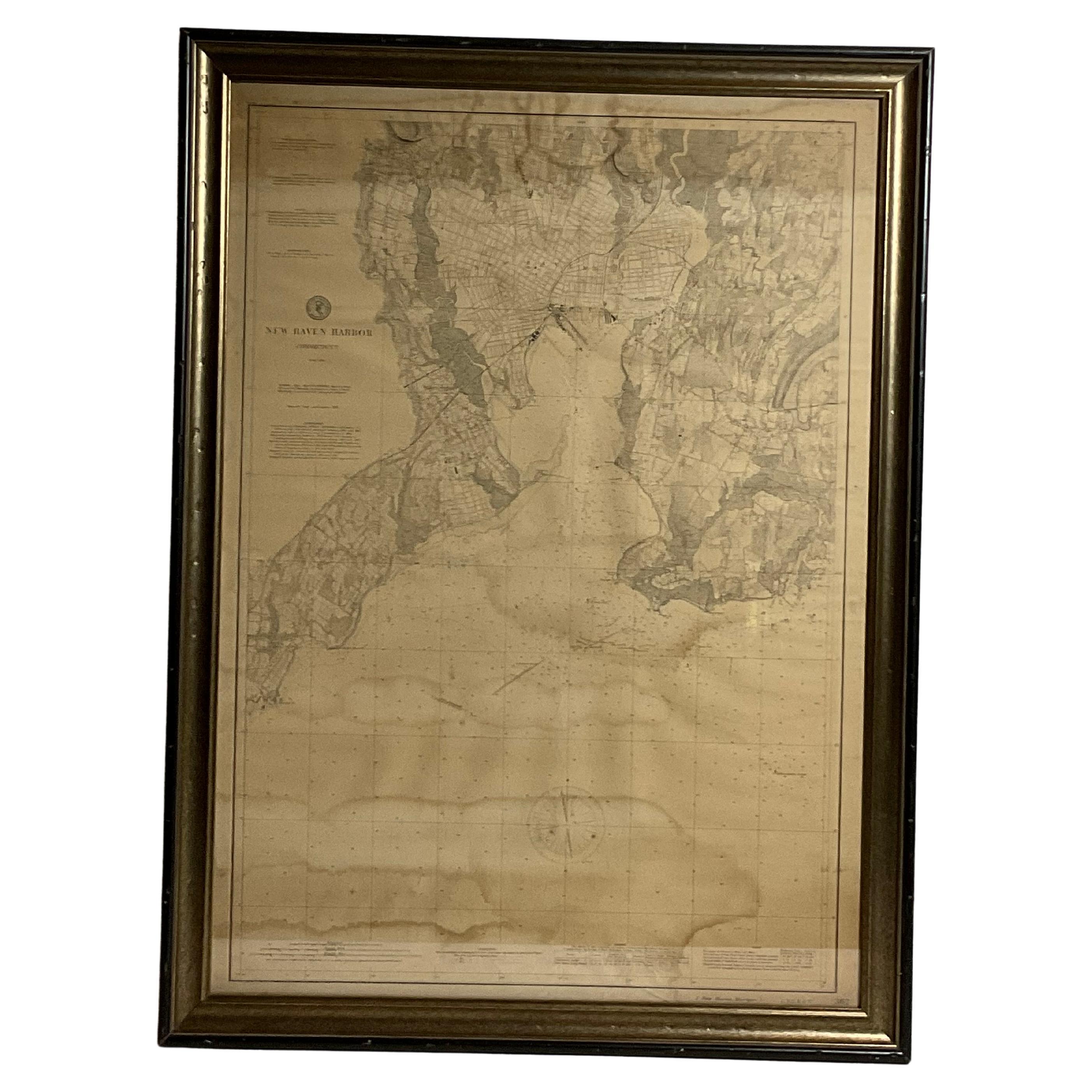
1896 Chart of the New Haven Harbor
Located in Norwell, MA
New Haven Harbor Chart published May 1896 by the United States Coast and geodetic survey. This chart is also a map of the land around the harbor and etc., loaded with detail. Nicely ...
Category
Antique 1890s North American Prints
Materials
Paper

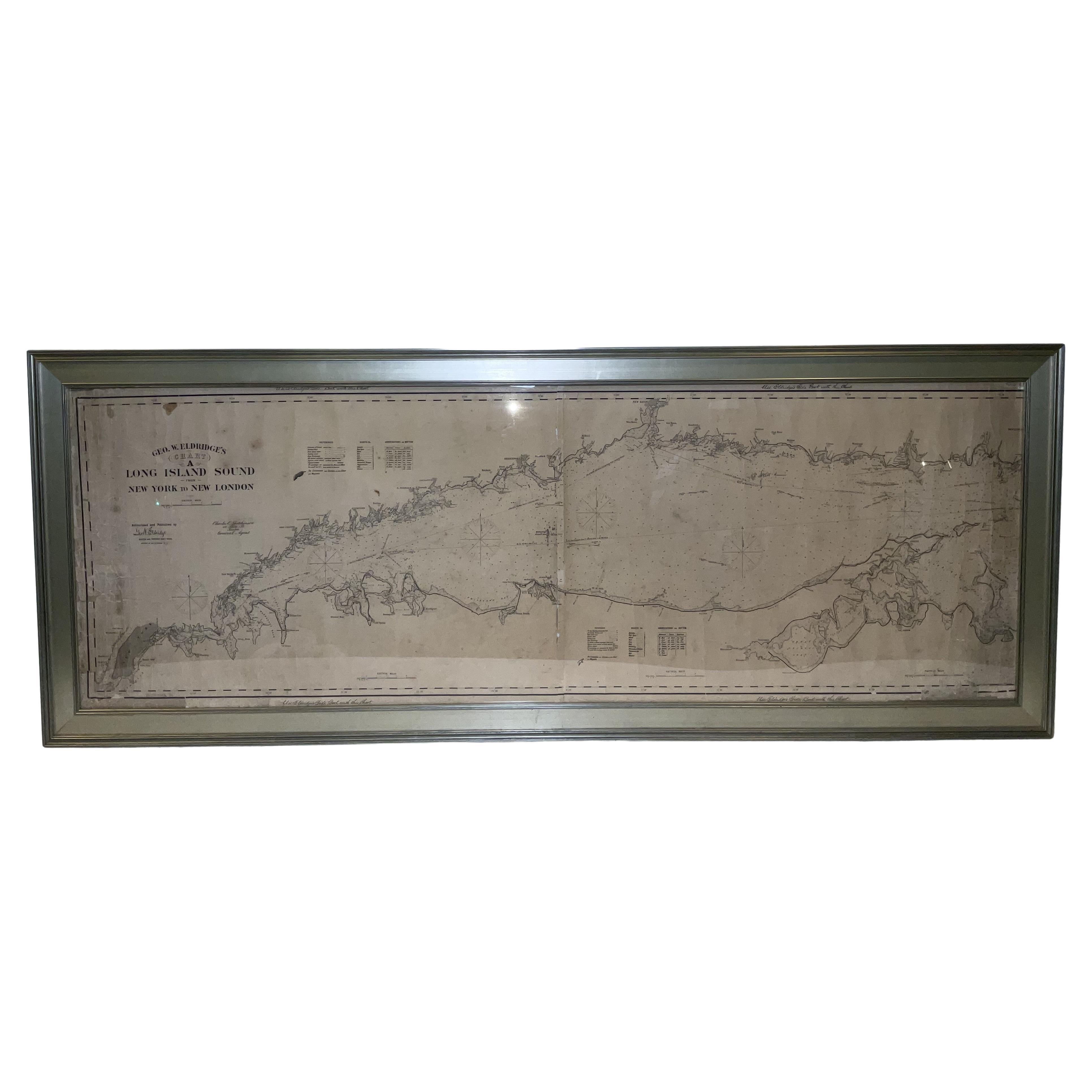
1905 Chart of Long Island Sound by Eldridge
Located in Norwell, MA
Original chart of Long Island Sound by George Eldridge, date-stamped 1905. Also includes the seller's name, Ships Chandler Charles C. Hutchinson, 152 State St., Boston, General Agent...
Category
Antique Early 1900s North American Prints
Materials
Paper
You May Also Like
DesBarres (1776) Chart of Nantucket Island, 1966 Restrike
Located in Nantucket, MA
DesBarres (1776) Chart of Nantucket Island and the Eastern Half of Martha's Vineyard Restrike, published by the Massachusetts Historical Society in association with Haley
Steel...
Category
Vintage 1960s American Other Maps
Materials
Paper
Scarce U.S. Coast Survey Map Depicting Entrance to San Francisco Bay Dated 1856
Located in San Francisco, CA
A fine example of the 1856 U.S. Coast lithographic survey nautical chart of the entrance to San Francisco bay and the city. Published in 1856 by the Office of the Coast Survey the of...
Category
Antique Mid-19th Century American Maps
Materials
Paper

$780 Sale Price
47% Off
Vintage 50s Original Topographical Map of the Florida Keys
Located in West Palm Beach, FL
A fabulous vintage Coastal original topographical map. A view of the Florida Keys and surrounding waters. Part of a trio of three maps. Al three are a...
Category
Mid-20th Century American Decorative Art
Materials
Glass, Wood, Paper

1856 U.S. Coast Survey Map of Chesapeake Bay and Delaware Bay
Located in Colorado Springs, CO
Presented is U.S. Coast Survey nautical chart or maritime map of Chesapeake Bay and Delaware Bay from 1856. The map depicts the region from Susquehanna, Maryland to the northern Outer Banks in North Carolina. It also shows from Richmond and Petersburg, Virginia to the Atlantic Ocean. The map is highly detailed with many cities and towns labeled throughout. Rivers, inlets, and bays are also labeled. Various charts illustrating more specific parts of the region are marked on the map using dotted lines. The lines form boxes, and the corresponding chart number and publication date are given. Extensive triangulation surveys were conducted the length of Chesapeake Bay and are illustrated here. Hampton Roads, Virginia is labeled, along with the James, York, and Rappahannock Rivers, which were all extensively surveyed.
The chart was published under the supervision of A. D. Bache, one of the most influential and prolific figures in the early history of the U.S. Coast Survey, for the 1856 Report of the Superintendent of the U.S. Coast Survey. Alexander Dallas Bache (1806-1867) was an American physicist, scientist, and surveyor. Bache served as the Superintendent of the U.S. Coast Survey from 1843 to 1865. Born in Philadelphia, Bache toured Europe and composed an important treatise on European Education. He also served as president of Philadelphia's Central High School and was a professor of natural history and chemistry at the University of Pennsylvania. Upon the death of Ferdinand Rudolph Hassler, Bache was appointed Superintendent of the United States Coast Survey.
The Office of the Coast Survey, founded in 1807 by President Thomas Jefferson and Secretary of Commerce Albert Gallatin...
Category
Antique 1850s American Maps
Materials
Paper

19th Century Chart of New England Coast, 1847
By U.S. Government
Located in Nantucket, MA
19th Century Chart of New England Coast: the U.S. Coast Survey Sketch A - Section 1, a triangulation chart showing the progress of the survey and details along the New England coas...
Category
Antique 1840s American Other Maps
Materials
Paper

Maps of Nantucket Sound and Harbor Provenance: The Susie Hilfiger Collection
Located in Bristol, CT
Map Sz: 22 1/2"H x 17"W
Frame Sz: 26 1/2"H x 20 3/4"W
*w/ age toning/ slight creasing/ waving to mounted maps*
Provenance: The Susie Hilfiger Collection
From "Point of View", the...
Category
20th Century Drawings and Watercolor Paintings
Materials
Paper
More Ways To Browse
19th Century Damask Chairs
4 Panel Asian Silk Screens
4 Panel Japanese Wall Art
70s Mexican
Adoration Shepherds
African Ebony Wood
Air Du Temps Nina Ricci
Alfredo Barbini Bird
American Federal Chest
Ancient Chinese Ceramics
Antique Bell Stand
Antique Bombay Chest
Antique Bombay Chests
Antique Chinese Hat Stand
Antique Chinese Roof Tile
Antique Copper Scale
Antique Drop Pull Handles
Antique Furniture Feet Styles