Video Loading
Want more images or videos?
Request additional images or videos from the seller
1 of 13
"San Francisco, Upper California” 1851 Antique Map of San Francisco
$1,200List Price
About the Item
- Dimensions:Height: 14.25 in (36.2 cm)Width: 25 in (63.5 cm)Depth: 1 in (2.54 cm)
- Materials and Techniques:
- Place of Origin:
- Period:
- Date of Manufacture:1851
- Condition:Wear consistent with age and use. Lithograph in good condition. Some staining in upper margins, extending into image, but not obscuring image.
- Seller Location:Colorado Springs, CO
- Reference Number:Seller: M1041stDibs: LU909725085002
About the Seller
4.9
Platinum Seller
Premium sellers with a 4.7+ rating and 24-hour response times
Established in 2010
1stDibs seller since 2011
473 sales on 1stDibs
Typical response time: 4 hours
Authenticity Guarantee
In the unlikely event there’s an issue with an item’s authenticity, contact us within 1 year for a full refund. DetailsMoney-Back Guarantee
If your item is not as described, is damaged in transit, or does not arrive, contact us within 7 days for a full refund. Details24-Hour Cancellation
You have a 24-hour grace period in which to reconsider your purchase, with no questions asked.Vetted Professional Sellers
Our world-class sellers must adhere to strict standards for service and quality, maintaining the integrity of our listings.Price-Match Guarantee
If you find that a seller listed the same item for a lower price elsewhere, we’ll match it.Trusted Global Delivery
Our best-in-class carrier network provides specialized shipping options worldwide, including custom delivery.You May Also Like
Antique Map of Belgium by J. Tallis, circa 1851
Located in Langweer, NL
A highly decorative and detailed mid-19th century map of Belgium which was drawn and engraved by J. Rapkin (vignettes by J. Marchant and J. B. Allen) an...
Category
Antique Mid-19th Century British Maps
Materials
Paper

$223 Sale Price
25% Off
H 10.56 in W 14.73 in D 0.02 in
Antique Map of Switzerland by J. Tallis, circa 1851
Located in Langweer, NL
A decorative and detailed mid-19th century map of Switzerland which was drawn and engraved by J. Rapkin (vignettes by A. H. Wray & J. B. Allen) and published in John Tallis's Illustr...
Category
Antique Mid-19th Century British Maps
Materials
Paper

$262 Sale Price
20% Off
H 10.48 in W 14.69 in D 0.02 in
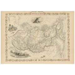
Antique Map of Russia in Asia by Tallis,
1851
Located in Langweer, NL
Antique map titled 'Russia in Asia'. Map of Russia in Asia. Showing vignettes of a polar hunting scene, Skorskarskoi Pagost, Troitsk and Kamchatkan Dogs. Originates from 'The Illustr...
Category
Antique Mid-19th Century Maps
Materials
Paper
Antique Map of Northern Italy by J. Tallis, circa 1851
Located in Langweer, NL
A highly decorative mid-19th century map of Northern Italy which was drawn and engraved by John Rapkin (vignettes by A. H. Wray & J. B. Allen) and published in John Tallis & co.'s Th...
Category
Antique Mid-19th Century British Maps
Materials
Paper

Antique Map of Southern Italy by J. Tallis, circa 1851
Located in Langweer, NL
Decorative and detailed mid-19th century map of Southern Italy which was drawn and engraved by John Rapkin (vignettes by A. H. Wray and J. Rogers...
Category
Antique Mid-19th Century British Maps
Materials
Paper
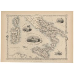
$245 Sale Price
25% Off
H 10.52 in W 14.57 in D 0.02 in
Antique Map of Asia Minor by J. Tallis, circa 1851
Located in Langweer, NL
A highly decorative mid-19th century map of 'Asia Minor' (modern day Turkey) which was drawn and engraved by J. Rapkin and published in John Tallis's Illust...
Category
Antique Mid-19th Century British Maps
Materials
Paper

$262 Sale Price
20% Off
H 10.56 in W 14.65 in D 0.02 in
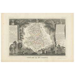
Antique Map of Upper Vienne ‘France’ by V. Levasseur, 1854
By Victor Levasseur
Located in Langweer, NL
Antique map titled 'Dépt. de La Hte. Vienne'. Antique map of Department of Upper Vienne with capital city Limoges, in the region of Limousin. This map originates from ‘Atlas National...
Category
Antique Mid-19th Century Maps
Materials
Paper
Original Antique English County Map, Nottinghamshire, J
C Walker, 1851
Located in St Annes, Lancashire
Great map of Nottinghamshire
Original colour
By J & C Walker
Published by Longman, Rees, Orme, Brown & Co. 1851
Unframed.
Category
Antique 1850s English Other Maps
Materials
Paper

$50
Free Shipping
H 13.75 in W 17.25 in D 0.07 in
Original Antique English County Map, Herefordshire, J
C Walker, 1851
Located in St Annes, Lancashire
Great map of Herefordshire
Original colour
By J & C Walker
Published by Longman, Rees, Orme, Brown & Co. 1851
Unframed.
Category
Antique 1850s English Other Maps
Materials
Paper

$50
Free Shipping
H 13.75 in W 17.25 in D 0.07 in
Original Antique English County Map, Rutland, J
C Walker, 1851
Located in St Annes, Lancashire
Great map of Rutland
Original colour
By J & C Walker
Published by Longman, Rees, Orme, Brown & Co. 1851
Unframed.
Category
Antique 1850s English Other Maps
Materials
Paper

$90
Free Shipping
H 13.75 in W 17.25 in D 0.07 in
More From This Seller
View AllAntique Map of Paris, "Carte Routiere des Environs de Paris" 1841
Located in Colorado Springs, CO
This beautiful hand-colored road map of Paris was published in 1841. The map shows Paris and the surrounding area in a folding pocket map. Organized and detailed for travelers, this ...
Category
Antique 1840s French Maps
Materials
Paper

1915 "San Francisco City and County" Hanging Map by W. Bashford Smith
Located in Colorado Springs, CO
Presented is a rare wall map of San Francisco by W. Bashford Smith. Published in San Francisco in 1915, this map indicates streets and city districts, and, most notably, shows the si...
Category
Vintage 1910s American Art Deco Maps
Materials
Wood, Paper

1847 Antique Map of Mexico, Texas and California by Samuel Augustus Mitchell
By Samuel Augustus Mitchell 1
Located in Colorado Springs, CO
Presented is the second edition of Samuel Augustus Mitchell's Map of Mexico, Including Yucatan & Upper California, an important map showing the progress of the Mexican-American War. ...
Category
Antique 1840s American Maps
Materials
Paper

“A Football Match, Scotland v. England” Antique Engraving, Proof Edition of 100
By Overend and Smythe
Located in Colorado Springs, CO
This is the 1889 William H. Overend (1851-1898) and Lionel Smythe (1839-1918) first edition, photogravure of the Calcutta Cup – a Rugby match between Scotland and England, that has been played over 100 times, the first match...
Category
Antique 19th Century English Prints
Materials
Paper

N.E. View of the United States Capitol, Washington, DC Antique Proof Print 1858
Located in Colorado Springs, CO
This engraved print shows a view of the United States Capitol Building, in Washington, D.C. The print depicts the neoclassical building from the northeast orientation, with a bustling street scene in front. The steel engraving is a proof printing, drawn and engraved by Henry Sartain and published in 1858.
Plans began in May 1854 to build a new cast-iron dome for the United States Capitol. The then-architect of the Capitol Thomas Walter and his team were sold on the aesthetics of a new dome, as well as the utility of a fire-proof one. A year later, on March 3, 1855, President Franklin Pierce...
Category
Antique 1850s American Prints
Materials
Paper

"Lady Washington
s Reception, " Engraved by A. H. Ritchie, Antique Print, 1865
Located in Colorado Springs, CO
This 1865, hand-colored engraving by A. H. Ritchie is entitled Lady Washington's Reception and is based on Daniel F. Huntington's original painting "Th...
Category
Antique 1860s American Prints
Materials
Paper

Still Thinking About These?
All Recently ViewedMore Ways To Browse
Esther Lewis
Fernand Leger Signed Prints
Framed Puck Political Cartoon
G Harvey Prints
Glenn Barr
Grote Bonte Specht
Group Of Seven Canada
Guangzhou Antique Market
H Herrmann Furniture
Harrison Fisher Antique Prints
Herrings Fox Hunting
Ike Ude
Inagaki Nenjiro
J And E Gould
J Harris Engraving
Jack Youngerman Lithograph
Jean Lurcat Zodiac
John Gould Toucans