Items Similar to Very Rare Antique Print of the City of Nice in France, c.1700


Want more images or videos?
Request additional images or videos from the seller
1 of 6
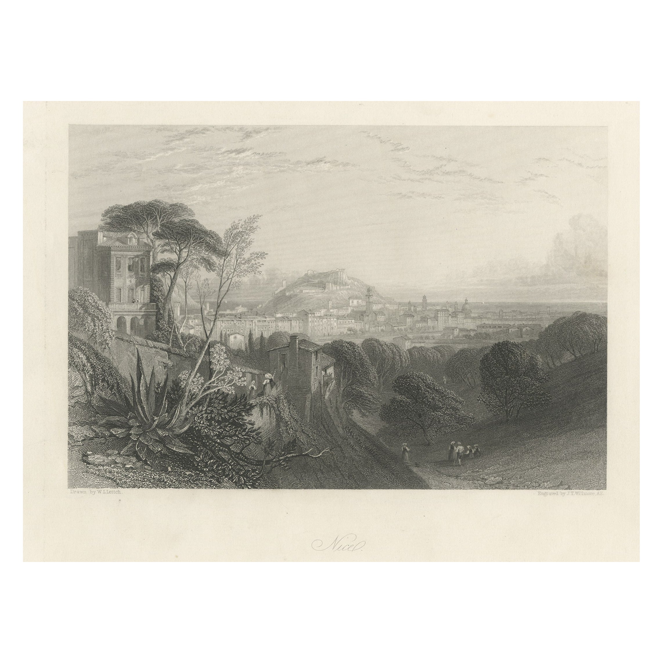
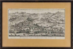
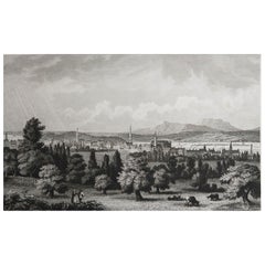
Very Rare Antique Print of the City of Nice in France, c.1700
$693.80
£515.18
€580
CA$953.24
A$1,036.75
CHF 549.44
MX$12,422.49
NOK 6,983.13
SEK 6,397.49
DKK 4,421.98
About the Item
Antique print titled 'Nicaea Civitas'. Original antique print with a view of the city of Nice, France. Rare in this edition. Source unknown, to be determined.
Artists and Engravers: Anonymous.
Condition: Fair/good, general age-related toning. Original folding line, some wear. Shows overall creasing. Blank verso, please study image carefully.
Date: c.1700
Overall size: 38.5 x 30.5 cm.
Image size: 28.5 x 23 cm.
Antique prints have long been appreciated for both their aesthetic and investment value. They were the product of engraved, etched or lithographed plates. These plates were handmade out of wood or metal, which required an incredible level of skill, patience and craftsmanship. Whether you have a house with Victorian furniture or more contemporary decor an old engraving can enhance your living space. We offer a wide range of authentic antique prints for any budget.
- Dimensions:Height: 12.01 in (30.5 cm)Width: 15.16 in (38.5 cm)Depth: 0 in (0.01 mm)
- Materials and Techniques:
- Period:
- Date of Manufacture:circa 1700
- Condition:Condition: Fair/good, general age-related toning. Original folding line, some wear. Shows overall creasing. Blank verso, please study image carefully.
- Seller Location:Langweer, NL
- Reference Number:Seller: BG-12882-191stDibs: LU3054329224622
About the Seller
5.0
Recognized Seller
These prestigious sellers are industry leaders and represent the highest echelon for item quality and design.
Platinum Seller
Premium sellers with a 4.7+ rating and 24-hour response times
Established in 2009
1stDibs seller since 2017
2,823 sales on 1stDibs
Typical response time: 1 hour
- ShippingRetrieving quote...Shipping from: Langweer, Netherlands
- Return Policy
More From This Seller
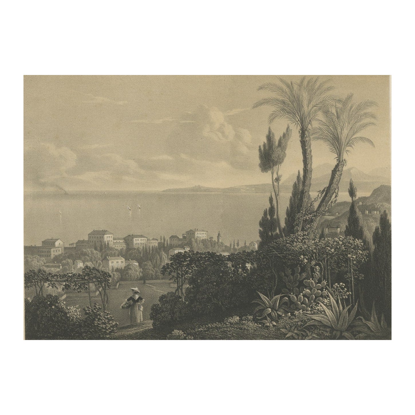
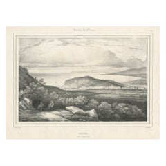
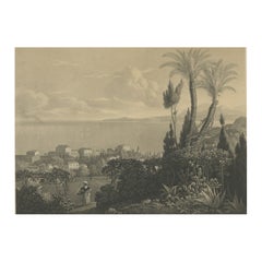
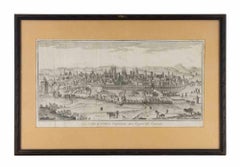
View AllAntique Print of the City of Nice in Southern France, c.1860
Located in Langweer, NL
Antique print titled 'Nice Vue Générale'. View of the city of Nice, France. Source unknown, to be determined.
Artists and Engravers: Lithographed by Villain. Published by Victor D...
Category
Antique 19th Century Prints
Materials
Paper
Antique Print of the City of Japha
Jaffa, Israel
by N. Sanson, 1709
Located in Langweer, NL
Antique print titled 'Joppe; in 't Hebreeusch by ouds Japho; hedendaags Japha of Jaffa; volgens d'aftekening gedan 1668.' This print was published in 1709 by N. Sanson.
Category
Antique Early 18th Century Prints
Materials
Paper
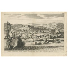
$344 Sale Price
20% Off
Antique Print of the City of Nice in Southern France, 1856
Located in Langweer, NL
Antique print titled 'Nice, Nizza'. View of the city of Nice, France. This print originates from 'Italy, Classical, Historical and Picturesque' by Camillo Mapei.
Artists and Engra...
Category
Antique 19th Century Prints
Materials
Paper
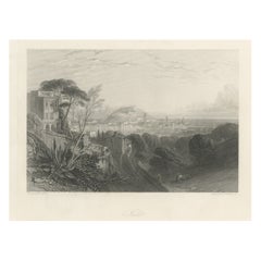
Antique Print of the City of Nice in France, c.1840
Located in Langweer, NL
Antique print titled 'Bei Nizza am Gulf Juan'. Original antique print with a view of Nice, France. This print originates from 'Aus dem König-Ludwigs-Album'. Published circa 1840.
...
Category
Antique 19th Century Prints
Materials
Paper
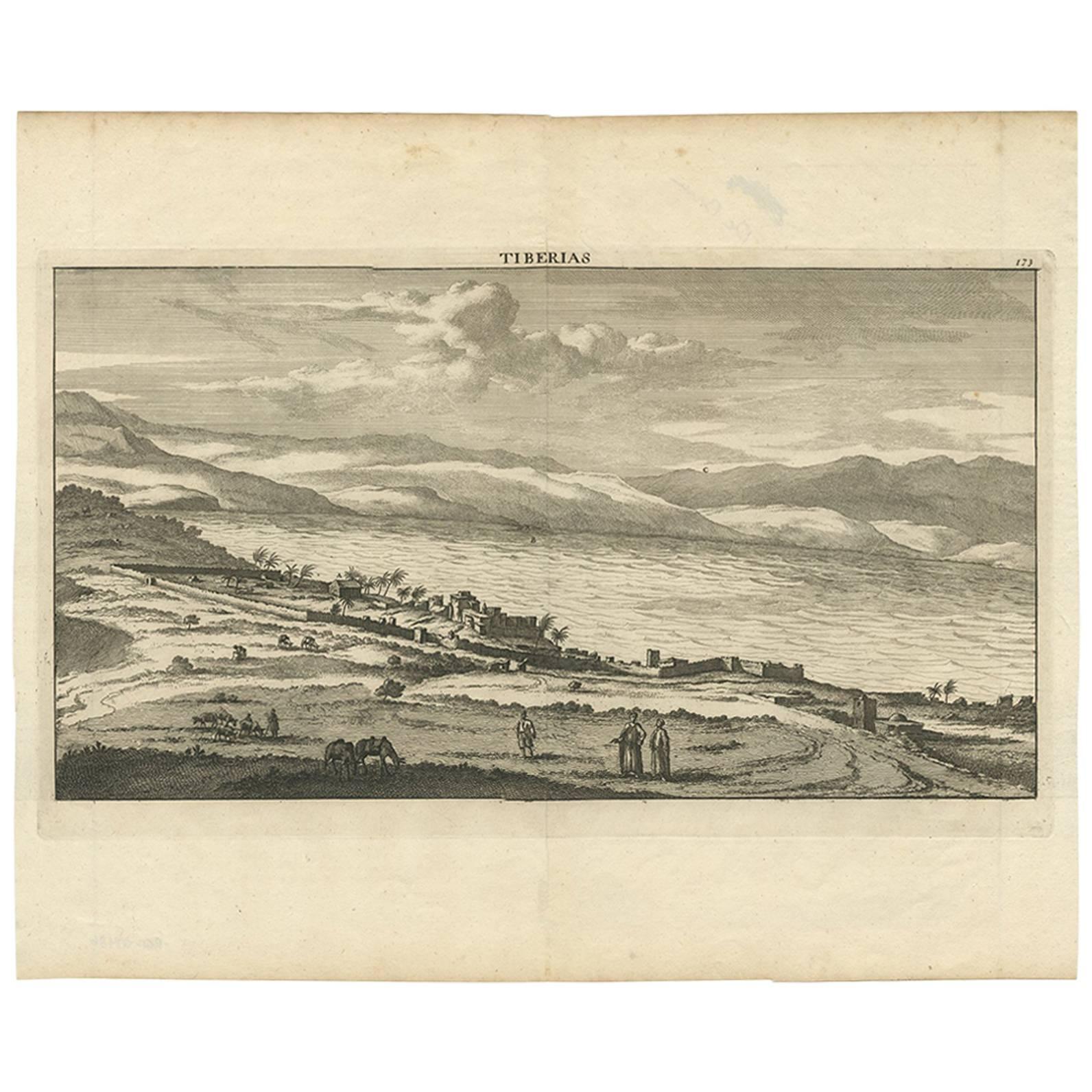
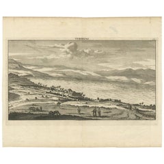
Antique Print of Tiberias
Israel
by C. le Brun, 1700
Located in Langweer, NL
Plate 173: 'Tiberias.' This plate shows a panoramic view of Tiberias on the Sea of Galilee, Israel. This scarse plate originates from: 'Voyage au Levant...
Category
Antique Early 18th Century Prints
Materials
Paper
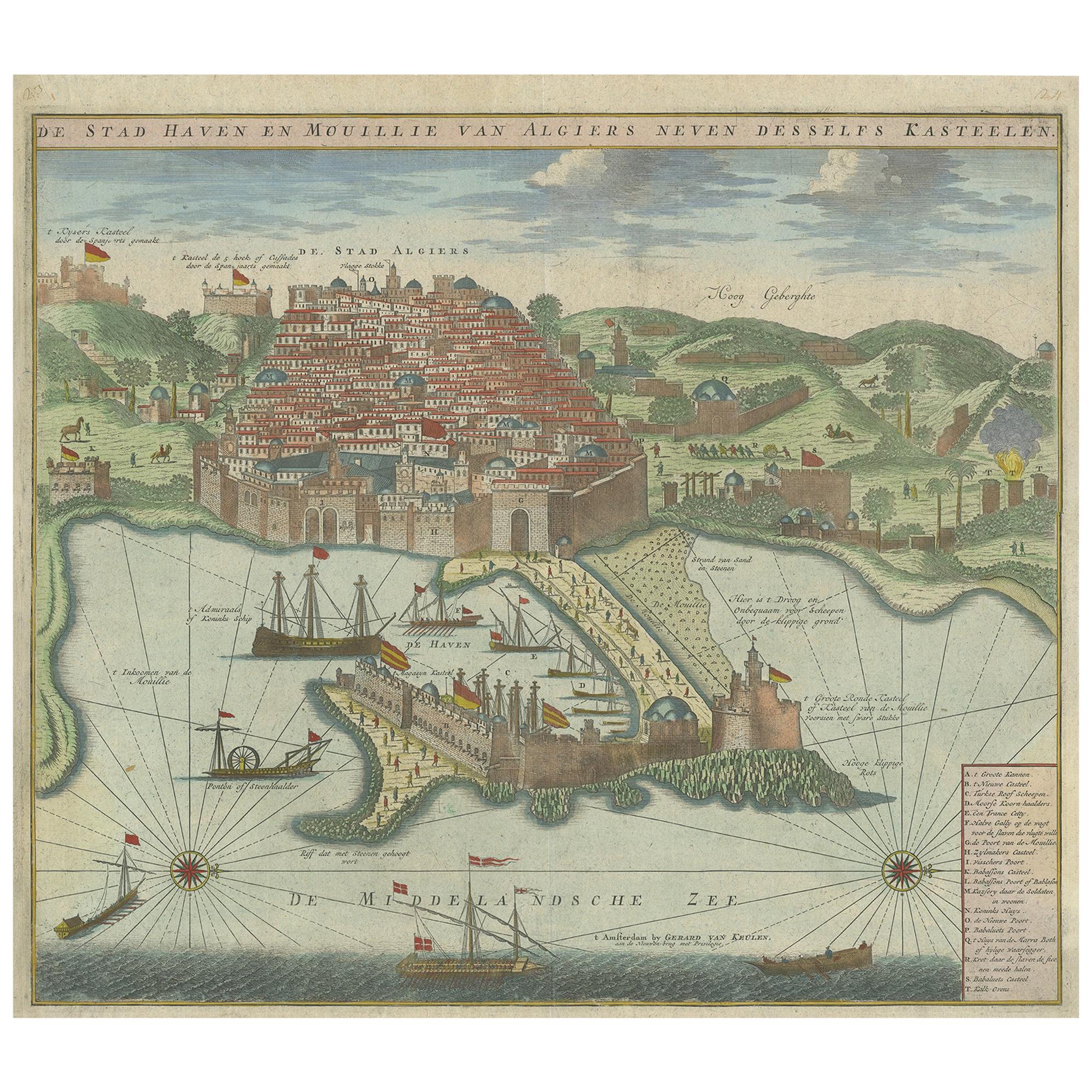
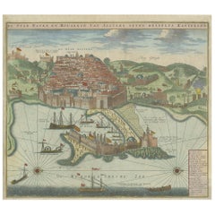
Antique Print of the Port and City of Algiers by Van Keulen, circa 1720
Located in Langweer, NL
Antique print titled 'De Stad Haven en Mouillie van Algiers neven desselfs Kastelen'. Rare double-page bird's-eye view of the port and city of Algiers. With detailed key in the lower right corner. Published by G. van Keulen...
Category
Antique Early 18th Century Dutch Prints
Materials
Paper
$1,345 Sale Price
25% Off
You May Also Like
Ancient View of Lyon - Etching - 1748
Located in Roma, IT
Etching on paper realized in 1748.
Very good condition except for some minor foxing.
Includes a wooden frame cm. 27.5x41.5
Category
1740s Modern Figurative Prints
Materials
Etching
18th Century French Map and City View of Joppe/Jaffa (Tel Aviv) by Sanson
By Nicholas Sanson d
Abbeville
Located in Alamo, CA
An original antique engraving entitled "Joppe; in ’t Hebreeusch by ouds Japho; hedendaags Japha, of Jaffa; volgens d’aftekening gedaan 1668", by Nicholas Sanson d'Abbeville (1600 - 1667). This is a view of the city of Joppe (in Hebrew Japho), now called Japha or Jaffa, the harbor portion of modern day Tel Aviv, Israel as it appeared in 1668 . It depicts a very busy harbor with numerous boats. A large ship on the left appears to be firing its canons and a small ship on the right appears to be sitting very low in the water, either heavily loaded with cargo or sinking. The town is seen on the far shore with a fortress on a hill across in the background. The map is printed from the original Sanson copperplate and was published in 1709 by his descendants.
The map is presented in an ornate brown wood frame embellished by gold-colored leaves and gold inner trim with a double mat; the outer mat is cream-colored and the inner mat is black. There is a central vertical fold, as issued. There are two small spots in the lower margin and one in the upper margin, as well as two tiny spots adjacent to the central fold. 1717 is written below the date 1668 in the inscription. The map is otherwise in very good condition.
Another map of the "Holy Land" (by Claes Visscher in 1663), with an identical style frame and mat is available. This pair of maps would make a wonderful display grouping. Please see Reference #LU117324709892.
Artist: Nicholas Sanson d'Abbeville (1600 - 1667) and his descendents were important French cartographer's active through the 17th century. Sanson started his career as a historian and initially utilized cartography to illustrate his historical treatises. His maps came to the attention of Cardinal Richelieu and then King Louis XIII of France, who became a supporter and sponsor. He subsequently appointed Sanson 'Geographe Ordinaire du Roi' the official map maker to the king. Sanson not only created maps for the king, but advised him on geographical issues and curated his map collection...
Category
Early 1700s Prints and Multiples
Materials
Engraving

Ancient View of Paris - Etching - 1748
Located in Roma, IT
Etching on paper realized in 1748.
Very good condition except for some minor foxing.
Includes a wooden frame cm. 27.5x41.5
Category
1740s Modern Abstract Prints
Materials
Etching
Original Antique Print of Montreal, Canada, circa 1840
Located in St Annes, Lancashire
Wonderful image of Montreal
Fine steel engraving
Published by Thomas Kelly, London circa 1840
Unframed.
Category
Antique 1840s English Prints
Materials
Paper
18th Century French Map and City View of Joppe/Jaffa
Tel Aviv
by Sanson
By Nicolas Sanson
Located in Alamo, CA
An original antique engraving entitled "Joppe; in ’t Hebreeusch by ouds Japho; hedendaags Japha, of Jaffa; volgens d’aftekening gedaan 1668", by Nicholas Sanson d'Abbeville (1600 - 1667). This is a view of the city of Joppe (in Hebrew Japho), now called Japha or Jaffa, the harbor portion of modern day Tel Aviv, Israel as it appeared in 1668 . It depicts a very busy harbor with numerous boats. A large ship on the left appears to be firing its canons and a small ship on the right appears to be sitting very low in the water, either heavily loaded with cargo or sinking. The town is seen on the far shore with a fortress on a hill across in the background. The map is printed from the original Sanson copperplate and was published in 1709 by his descendants.
The map is presented in an ornate brown wood frame embellished by gold-colored leaves and gold inner trim with a double mat; the outer mat is cream-colored and the inner mat is black. There is a central vertical fold, as issued. There are two small spots in the lower margin and one in the upper margin, as well as two tiny spots adjacent to the central fold. 1717 is written below the date 1668 in the inscription. The map is otherwise in very good condition.
Another map of the "Holy Land" (by Claes Visscher in 1663), with an identical style frame and mat is available. This pair of maps would make a wonderful display grouping. Please see Reference #LU5206220653552. A discount is available for the purchase of the pair of maps.
Artist: Nicholas Sanson d'Abbeville (1600-1667) and his descendents were important French cartographer's active through the 17th century. Sanson started his career as a historian and initially utilized cartography to illustrate his historical treatises. His maps came to the attention of Cardinal Richelieu and then King Louis XIII of France, who became a supporter and sponsor. He subsequently appointed Sanson 'Geographe Ordinaire du Roi' the official map maker to the king. Sanson not only created maps for the king, but advised him on geographical issues and curated his map collection...
Category
Antique Early 18th Century French Maps
Materials
Paper

$860 Sale Price
20% Off
17th Century Topographical Map of Cote D
azur, Avignon, Frejus by Iohan Peeters
Located in New York, NY
Fine topographical 17th century map by Iohan Peeters of the towns of Avignon and Frejus in the Cote d'Azur-Provence-Alpes Region of Southeastern France.
Beautifully suited decorativ...
Category
Antique 17th Century Dutch Maps
Materials
Paper

More Ways To Browse
Vertical Wall Art
Vintage Arzberg Porcelain
Vintage Baccarat Bowl
Vintage Built In
Vintage Furniture Regina
Vintage Pink Planter
Vintage Sunroom
Vintage Tiki
Vintage Western Wall Art
Voided Velvet
Water Filter
White Ceramic Fruit
Wood Carved Swags
Wrought Iron Horse
Zani And Zani
18th Century Chest Of Drawers New England
18th Century Silhouette
1960 Surfboard