Want more images or videos?
Request additional images or videos from the seller
1 of 6
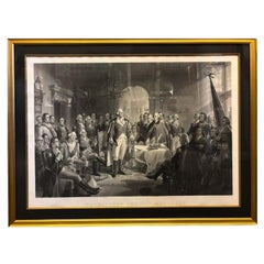
"Washington and His Generals" Antique Engraving by A.H. Ritchie, circa 1870
$6,920List Price
About the Item
- Creator:Alexander Hay Ritchie (Artist)
- Dimensions:Height: 41 in (104.14 cm)Width: 52 in (132.08 cm)Depth: 2 in (5.08 cm)
- Materials and Techniques:
- Place of Origin:
- Period:
- Date of Manufacture:1870
- Condition:Wear consistent with age and use.
- Seller Location:Colorado Springs, CO
- Reference Number:Seller: PR3841stDibs: LU909719369072
About the Seller
4.9
Gold Seller
Premium sellers maintaining a 4.3+ rating and 24-hour response times
Established in 2010
1stDibs seller since 2011
473 sales on 1stDibs
Typical response time: 4 hours
Authenticity Guarantee
In the unlikely event there’s an issue with an item’s authenticity, contact us within 1 year for a full refund. DetailsMoney-Back Guarantee
If your item is not as described, is damaged in transit, or does not arrive, contact us within 7 days for a full refund. Details24-Hour Cancellation
You have a 24-hour grace period in which to reconsider your purchase, with no questions asked.Vetted Professional Sellers
Our world-class sellers must adhere to strict standards for service and quality, maintaining the integrity of our listings.Price-Match Guarantee
If you find that a seller listed the same item for a lower price elsewhere, we’ll match it.Trusted Global Delivery
Our best-in-class carrier network provides specialized shipping options worldwide, including custom delivery.You May Also Like
Antique Map of Italy and Greece by H. Kiepert, circa 1870
By Heinrich Kiepert
Located in Langweer, NL
Antique map titled 'Italiae pars media'. This map originates from 'Atlas Antiquus. Zwölf Karten zur Alten Geschichte' by H. Kiepert. Published in Berlin, circa 187.
Category
Antique Late 19th Century Maps
Materials
Paper

Antique Map of Egypt and Palestina by H. Kiepert, circa 1870
By Heinrich Kiepert
Located in Langweer, NL
Antique map titled 'Aegyptus, Phoenice et Palestina'. With inset maps of Tyrus, Alexandria and Hierosolyma. This map originates from 'Atlas Antiquus. Zwölf Karten zur Alten Geschicht...
Category
Antique Late 19th Century German Maps
Materials
Paper

$153 Sale Price
20% Off
H 14.38 in W 18.31 in D 0.02 in
Antique Map of Spain, Mauritia and Africa by H. Kiepert, circa 1870
By Heinrich Kiepert
Located in Langweer, NL
Antique map titled 'Hispania, Mauretania et Africa'. This map originates from 'Atlas Antiquus. Zwölf Karten zur Alten Geschichte' by H. Kiepert. Published in Berlin, circa 1870.
Category
Antique Late 19th Century Maps
Materials
Paper
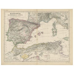
$179
H 14.38 in W 18.31 in D 0.02 in
Antique Map of Western Europe by H. Kiepert, circa 1870
By Heinrich Kiepert
Located in Langweer, NL
Antique map titled 'Gallia, Britannia, Germania'. This map depicts a large part of Western Europe including countries like Germany, France, Great Britain, The Netherlands and more. T...
Category
Antique Late 19th Century German Maps
Materials
Paper

Antique Print of General Elliot and his Troops by Raymond, circa 1787
Located in Langweer, NL
Antique print titled 'General Elliot haranguing his Troops, previous to the Attack (..)'. Engraving of General Elliot and his troops previous to the attack of the gun boats...
Category
Antique 18th Century Prints
Materials
Paper
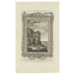
$105 Sale Price
20% Off
H 13.78 in W 8.47 in D 0 in
Antique Map of Spain and Portugal by A
C. Black, 1870
Located in Langweer, NL
Antique map titled 'Spain and Portugal'. Original antique map of General map of Spain and Portugal with inset map of Gibraltar. This map originates from ‘Black's General Atlas of The...
Category
Antique Late 19th Century Maps
Materials
Paper

$197 Sale Price
40% Off
H 17.52 in W 23.63 in D 0.02 in
Antique Map of Washington County
Ohio
by Titus, 1871
Located in Langweer, NL
Antique map titled 'Washington'. Original antique map of Washington, Ohio. This map originates from 'Atlas of Preble County Ohio' by C.O. Titus. Published, 1871.
Category
Antique Late 19th Century Maps
Materials
Paper
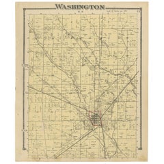
$224 Sale Price
24% Off
H 14.97 in W 12.41 in D 0.02 in
Antique Map of Part of the Roman Empire by H. Kiepert, circa 1870
By Heinrich Kiepert
Located in Langweer, NL
Antique map titled 'Imperia Persarum et Macedonum'. Depicts part of the Roman Empire, from Greece to Eastern India. This map originates from 'Atlas Antiqus. Zwölf Karten zur Alten Ge...
Category
Antique Late 19th Century Maps
Materials
Paper

$179
H 14.38 in W 18.31 in D 0.02 in
Antique Map of The Netherlands and Belgium by A
C, Black, 1870
Located in Langweer, NL
Antique map titled 'Holland & Belgium'. Original antique map of Map of The Netherlands and Belgium. This map originates from ‘Black's General Atlas of The World’. Published by A & C....
Category
Antique Late 19th Century Maps
Materials
Paper
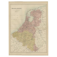
$239 Sale Price
20% Off
H 23.63 in W 17.52 in D 0.02 in
Antique Map of Greece and Ionian Islands by A
C. Black, 1870
Located in Langweer, NL
Antique map titled 'Hellas or Greece'. Original antique map of Greece and Ionian Islands with inset map of Corfu. This map originates from ‘Black's General Atlas of The World’. Publi...
Category
Antique Late 19th Century Maps
Materials
Paper

$167 Sale Price
20% Off
H 13 in W 17.52 in D 0.02 in
More From This Seller
View All"Washington and His Generals" Engraving by A. H. Ritchie, circa 1870
By Alexander Hay Ritchie
Located in Colorado Springs, CO
This is a large, handsome engraving entitled Washington and His Generals by Alexander H. Ritchie, one of the best historical printmakers of the mid-nineteenth century. Ritchie is par...
Category
Antique 1870s American Federal Prints
Materials
Paper
"Lady Washington
s Reception, " Engraved by A. H. Ritchie, Antique Print, 1865
Located in Colorado Springs, CO
This 1865, hand-colored engraving by A. H. Ritchie is entitled Lady Washington's Reception and is based on Daniel F. Huntington's original painting "Th...
Category
Antique 1860s American Prints
Materials
Paper

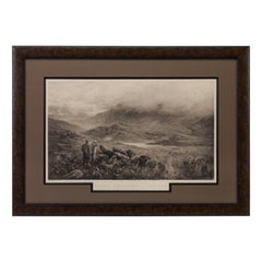
"Rough Shooting" First Edition Antique Engraving by Douglas Adams, circa 1893
By Douglas Adams
Located in Colorado Springs, CO
This is a first edition print of Rough Shooting, signed by the artist, Douglas Adams. The print was published by Thomas McLean and depicts a highlands s...
Category
Antique 1890s British Prints
Materials
Paper
N.E. View of the United States Capitol, Washington, DC Antique Proof Print 1858
Located in Colorado Springs, CO
This engraved print shows a view of the United States Capitol Building, in Washington, D.C. The print depicts the neoclassical building from the northeast orientation, with a bustling street scene in front. The steel engraving is a proof printing, drawn and engraved by Henry Sartain and published in 1858.
Plans began in May 1854 to build a new cast-iron dome for the United States Capitol. The then-architect of the Capitol Thomas Walter and his team were sold on the aesthetics of a new dome, as well as the utility of a fire-proof one. A year later, on March 3, 1855, President Franklin Pierce...
Category
Antique 1850s American Prints
Materials
Paper

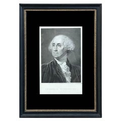
"Georgius Washington" Engraving by Giuseppe Longhi, 1817
Located in Colorado Springs, CO
Presented is a handsome engraved portrait of George Washington by Italian artist Giuseppe Longhi. Titled “Georgius Washington” this engraving was published in Padua, Italy in 1817. The composition is based on a drawing by Longhi himself, but certainly influenced by the Gilbert Stuart and John Trumbull portraits. Washington is depicted in a head and shoulders pose, with his chest to the left but his head angled to the right. He wears a dark coat and vest and a white shirt and ruffled cravat.
The father of our country, George Washington was the commander in chief of the Continental Army during the American Revolutionary War (1775-83) and served two terms as the first United States president...
Category
Antique 1810s Italian Federal Prints
Materials
Paper
“A Football Match, Scotland v. England” Antique Engraving, Proof Edition of 100
By Overend and Smythe
Located in Colorado Springs, CO
This is the 1889 William H. Overend (1851-1898) and Lionel Smythe (1839-1918) first edition, photogravure of the Calcutta Cup – a Rugby match between Scotland and England, that has been played over 100 times, the first match...
Category
Antique 19th Century English Prints
Materials
Paper

Still Thinking About These?
All Recently ViewedMore Ways To Browse
Benjamin Franklin Bust
Franklin Bust
Giovanni Ferraris
Horse Racing Prints
Jesus Healing
Maxfield Parrish Antique Prints
Napoleon And Marie Louise
Rubens Engraving
Signed Louis Icart
Albin Bird
Antique Bird Print Quail
Antique George Washington Print
Antique Korean Prints
Antique Swan Print
Arctic Tern
Biology Prints
Chinese Emperor Print
Edouard Travies