Articoli simili a 1870 "Johnson
s Europe" Map Published by A. J. Johnson


Vuoi altre immagini o video?
Richiedi altre immagini o video al venditore
1 di 10
1870 "Johnson
s Europe" Map Published by A. J. Johnson
1094 €
Informazioni sull’articolo
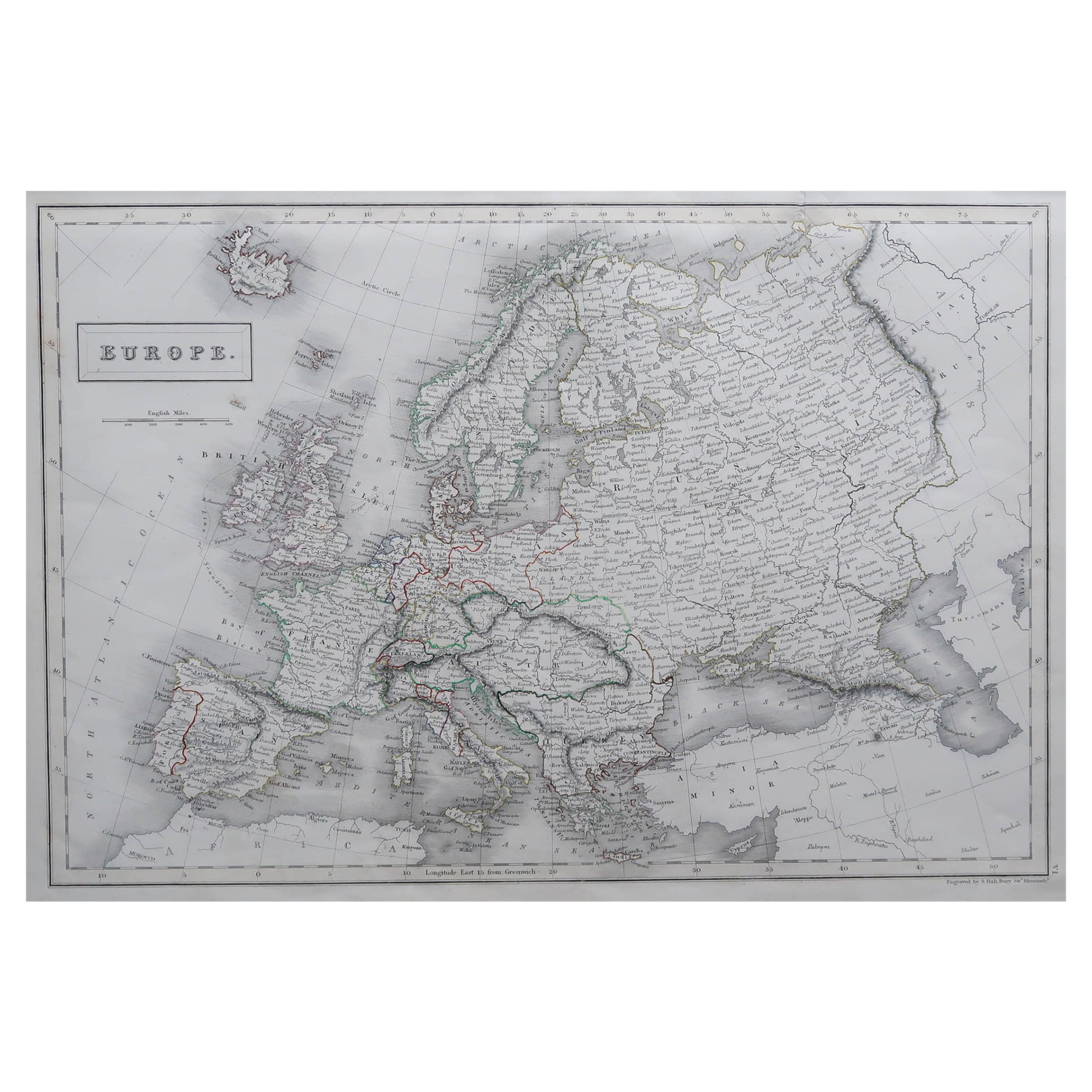
Presented is an original 1870 "Johnson’s Europe" map. First published in 1864, this map was issued as pages 87 and 88 in the 1870 edition of “Johnson's New Illustrated (Steel Plate) Family Atlas.” The map is engraved with attractive hand coloring and a decorative border. The countries of Europe are colored by country, and sometimes further colored by districts or rule. Included are the countries of Iceland, Ireland, England, Wales, Norway, Sweden, Russia, Prussia, Holland, Belgium, Bavaria, Austria, Switzerland, France, Italy, Spain, Portugal, Corsica, Sardinia, Turkey, Greece, and Crete. Russia is very large, divided by provinces, and includes within its borders Finland, Lapland, Baltic Provinces, Poland, West Russia, Little Russia, South Russia, Caucasian Provinces, Astrachan, and Kasan. Depicted but not colored are the border countries and continents of Greenland, Asia, Turkey in Asia, and Africa. The map is beautifully detailed, with cities, towns, railroads, and common roads identified, and mountains, rivers, and lakes depicted.
The publishing company of A.J. Johnson was a successor of Johnson and Ward, a successor to Johnson and Browning, themselves a successor to the famous publishing company, J. H. Colton and Company. A combination of both new plates and older, updated ones, all of the maps in this famous 1870 atlas were compiled, drawn, and engraved under the supervision of A. J. Johnson.
This 1870 publication of “Johnson's New Illustrated (Steel Plate) Family Atlas” is also notable for its inclusion of a treatise on physical geography by Professor A. Guyot, marking the first year his essay appeared and his name featured on the cover. The atlas was recognized with a First Prize Medal at the Universal Exposition of 1867 in Paris.
“Johnson's New Illustrated Family Atlas” was a comprehensive world atlas featuring 60 full-color maps. Designed to be both educational and a decorative addition to a home library, it reflected the 19th-century fascination with detailed and ornate cartographic publications. In addition to maps, the atlas included geographical, statistical, and historical information, as well as a dictionary of religious denominations, a testament to its extensive scope and utility. The treatise on physical geography by A. Guyot further demonstrates that period’s growing interest in scientific inquiry, making the atlas a valuable resource not just for navigation and geography, but also for understanding the natural world.
CONDITION:
Near fine condition. Hand Colored. Page 87 and 88 from “Johnson's New Illustrated (Steel Plate) Family Atlas.” Decorative border. Colored by country or province. Publication line: "Entered according to Act of Congress in the Year 1864, by A.J. Johnson, in the Clerks Office of the District Court of the United States for the Southern District of New York". Toning to paper, full margins, light staining at top.
Artfully framed in a custom-built wooden frame with UV glass and acid-free mats.
Framed Dimensions: 25 3/4"H x 31 3/4"W x 1 1/8"D.
Accompanied by our company's letter of authenticity.
- Dimensioni:Altezza: 65,41 cm (25,75 in)Larghezza: 80,65 cm (31,75 in)Profondità: 2,88 cm (1,13 in)
- Stile:Vittoriano (Del periodo)
- Materiali e tecniche:Carta,Inciso
- Luogo di origine:
- Periodo:
- Data di produzione:1870
- Condizioni:Aggiunte o modifiche apportate all originale: Framed to archival and conservation standards by Artem Art Services in Colorado Springs CO in November of 2025. Usura compatibile con l’età e l’utilizzo. Lieve sbiadimento.
- Località del venditore:Colorado Springs, CO
- Numero di riferimento:Venditore: M4321stDibs: LU909747859962
Informazioni sul venditore
4,9
Venditore Oro
Venditori Premium con valutazione 4,3+ e tempi di risposta entro 24 ore
Fondazione nel 2010
Venditore 1stDibs dal 2011
471 vendite su 1stDibs
Tempo di risposta standard: 5 ore
- SpedizioneRecupero del preventivo…Spedizione da: Colorado Springs, CO
- Politica di reso
Alcune parti di questa pagina sono state tradotte automaticamente. 1stDibs non può garantire che le traduzioni siano corrette. L’inglese è la lingua predefinita del sito.
Altro da questo venditore
Mostra tuttoMappa del 1866 "Johnson
s United States", pubblicata da Johnson and Ward
Viene presentata una mappa dettagliata degli Stati Uniti di A. J. Johnson. La mappa, che copre l'intero territorio continentale degli Stati Uniti e le parti adiacenti del Canada e de...
Categoria
Di antiquariato/d’epoca, Anni 1860, Americano, Vittoriano, Mappe
Materiali
Carta

1870 "Johnson
s World" del Prof. A. Guyot, edito da A. Johnson
Viene presentato un originale "Johnson's World, Showing the Distribution of the Characteristic Forest Trees, Principal Useful Plants and Minerals" del Prof. A. Guyot. Questa mappa è ...
Categoria
Di antiquariato/d’epoca, Anni 1870, Americano, Vittoriano, Mappe
Materiali
Carta
1856 "Mappa degli Stati Uniti" di Ensign, Bridgeman e Fanning
Viene presentata una rara carta murale americana degli Stati Uniti e del Messico pubblicata da Ensign, Bridgman e Fanning nel 1856. Come suggerisce il titolo, la mappa copre tutti gl...
Categoria
Di antiquariato/d’epoca, Anni 1850, Americano, Vittoriano, Mappe
Materiali
Carta

Mappa del Nord America del 1864, Carta geografica antica colorata a mano, di Adolphe Hippolyte Dufour
Viene offerta una mappa del Nord America intitolata Amerique du Nord del 1864. Questa rara mappa murale, pubblicata separatamente, è stata realizzata da Adolphe Hippolyte Dufour. Que...
Categoria
Di antiquariato/d’epoca, Anni 1860, Francese, Mappe
Materiali
Carta

1859 "Mappa degli Stati Uniti d
America..." di J.H. Colton
Di J.H. Colton
Viene presentata una "Mappa degli Stati Uniti d'America, delle Province Britanniche, del Messico, delle Indie Occidentali e dell'America Centrale con parte della Nuova Granada e del ...
Categoria
Di antiquariato/d’epoca, Anni 1850, Americano, Mappe
Materiali
Carta

Mappa "Texas" del 1894
Viene presentata una mappa molto dettagliata del Texas, risalente al 1894. La mappa è molto completa, colorata per contee e delineata in rosso. La mappa mostra la topografia, i fiumi...
Categoria
Di antiquariato/d’epoca, Anni 1890, Americano, Vittoriano, Mappe
Materiali
Carta
Ti potrebbe interessare anche
Carta geografica antica dell
Europa di Johnson, 1872
Carta geografica antica intitolata "L'Europa di Johnson". Mappa originale dell'Europa. Questa mappa proviene da "Johnson's New Illustrated Family Atlas of the World" di J. Johnson. J...
Categoria
Di antiquariato/d’epoca, Fine XIX secolo, Mappe
Materiali
Carta

280 € Prezzo promozionale
20% in meno
Mappa antica del continente europeo, 1882
Carta geografica antica intitolata "Europa". Antica mappa del continente europeo. Questa mappa proviene da "The Royal Atlas of Modern Geography, Exhibiting, in a Series of Entirely O...
Categoria
Di antiquariato/d’epoca, XIX secolo, Mappe
Materiali
Carta

Grande mappa antica originale dell
Europa di Sidney Hall, 1847
Grande mappa dell'Europa
Disegnato e inciso da Sidney Hall
Incisione in acciaio
Schema originale a colori
Pubblicato da A & C Black. 1847
Non incorniciato
Spedizio...
Categoria
Di antiquariato/d’epoca, Anni 1840, Scozzese, Mappe
Materiali
Carta

Mappa antica del continente europeo, 1880
Carta geografica antica intitolata "Europa". Antica mappa del continente europeo. Questa mappa proviene da "Géographie Universelle Atlas-Migeon" di J. Migeon.
Artisti e incisori: ...
Categoria
Di antiquariato/d’epoca, XIX secolo, Mappe
Materiali
Carta

Carta geografica antica dell
Europa di W. G. Blackie, 1859
Carta geografica antica intitolata "Europa". Mappa antica originale dell'Europa. Questa mappa proviene da "The Imperial Atlas of Modern Geography". Pubblicato da W. G. Blackie, 1859.
Categoria
Di antiquariato/d’epoca, Metà XIX secolo, Mappe
Materiali
Carta

200 € Prezzo promozionale
20% in meno
Carta geografica antica dell
Europa da un vecchio atlante scolastico olandese, 1852
Mappa antica intitolata "Europa". Mappa dell'Europa. Questa mappa proviene da "School-Atlas van alle deelen der Aarde" di Otto Petri.
Artisti e incisori: Pubblicato da A. Baedeke...
Categoria
Di antiquariato/d’epoca, XIX secolo, Mappe
Materiali
Carta
