Articoli simili a Ancient Egypt – Nile Valley Map by d’Anville, Classical Antiquity, c.1765


Vuoi altre immagini o video?
Richiedi altre immagini o video al venditore
1 di 9
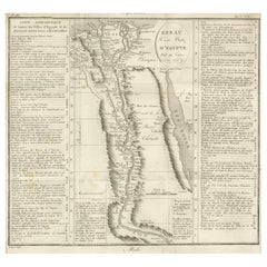
Ancient Egypt – Nile Valley Map by d’Anville, Classical Antiquity, c.1765
570 €IVA inclusa
Informazioni sull’articolo
Ancient Egypt – Nile Valley Map by d’Anville, Classical Antiquity, c.1765
This finely engraved map depicts Ancient Egypt as understood through classical sources, extending along the Nile Valley from the Mediterranean Delta southward into Nubia, with adjacent regions of Arabia Petraea and the Red Sea coast. The map is titled “Ægyptus Antiqua” and was compiled by Jean-Baptiste Bourguignon d’Anville, one of the most influential and scholarly cartographers of the 18th century.
D’Anville’s approach marked a decisive shift away from speculative geography. Drawing on ancient Greek and Roman authors such as Herodotus, Strabo, Pliny, and Ptolemy, he sought to reconstruct the geography of antiquity with critical rigor. Cities, nomes, temples, and classical place names are carefully plotted along the Nile, offering a structured and historically grounded vision of Pharaonic Egypt as interpreted through classical antiquity.
The Nile dominates the composition, rendered as the organizing spine of Egyptian civilization. Branches of the Delta, desert regions, and mountain ranges are delicately engraved, while subtle hand color highlights coastlines and regional boundaries without overwhelming the clarity of the map. To the east, the Red Sea and Arabian Peninsula provide geographical context for ancient trade routes and cultural exchange.
Visually, the map balances scholarship and elegance. The restrained engraving style, generous white space, and vertical format give it a calm, architectural presence, making it particularly attractive for interior display. It works equally well as a collector’s piece or as a refined statement map in both classic and contemporary settings.
This map is highly sought after by collectors of Egyptology, classical history, and Enlightenment cartography, and it pairs beautifully with other 18th-century maps of North Africa, the Mediterranean, or the ancient world.
Condition report
Good condition overall. Light age toning. Original outline hand color. Plate mark visible. Margins intact. Right margin tight. Strong paper.
Framing tips
A wide off-white or light sand-colored mat enhances the vertical composition and emphasizes the Nile’s flow through the map. A medium to dark wood frame or softly ebonized frame gives the piece a refined, museum-style appearance, suitable for both residential and hospitality interiors.
Technique: Copper engraving with contemporary outline hand color
Maker: Jean-Baptiste Bourguignon d’Anville, France, c.1765
- Dimensioni:Altezza: 55,7 cm (21,93 in)Larghezza: 37,5 cm (14,77 in)Profondità: 0,2 mm (0,01 in)
- Materiali e tecniche:Carta,Inciso
- Luogo di origine:
- Periodo:
- Data di produzione:circa 1765
- Condizioni:Good condition overall. Light age toning. Original outline hand color. Plate mark visible. Margins intact. Right margin tight. Strong paper.
- Località del venditore:Langweer, NL
- Numero di riferimento:Venditore: BG-14128-161stDibs: LU3054348017302
Informazioni sul venditore
5,0
Venditore riconosciuto
Questi venditori prestigiosi sono leader del settore e rappresentano il massimo in termini di qualità e design.
Venditore Platino
Venditori Premium con valutazione 4.7+ e tempi di risposta entro 24 ore
Fondazione nel 2009
Venditore 1stDibs dal 2017
2813 vendite su 1stDibs
Tempo di risposta standard: 1 ora
- SpedizioneRecupero del preventivo…Spedizione da: Langweer, Paesi Bassi
- Politica di reso
Alcune parti di questa pagina sono state tradotte automaticamente. 1stDibs non può garantire che le traduzioni siano corrette. L’inglese è la lingua predefinita del sito.
Altro da questo venditore
Mostra tuttoEgypt
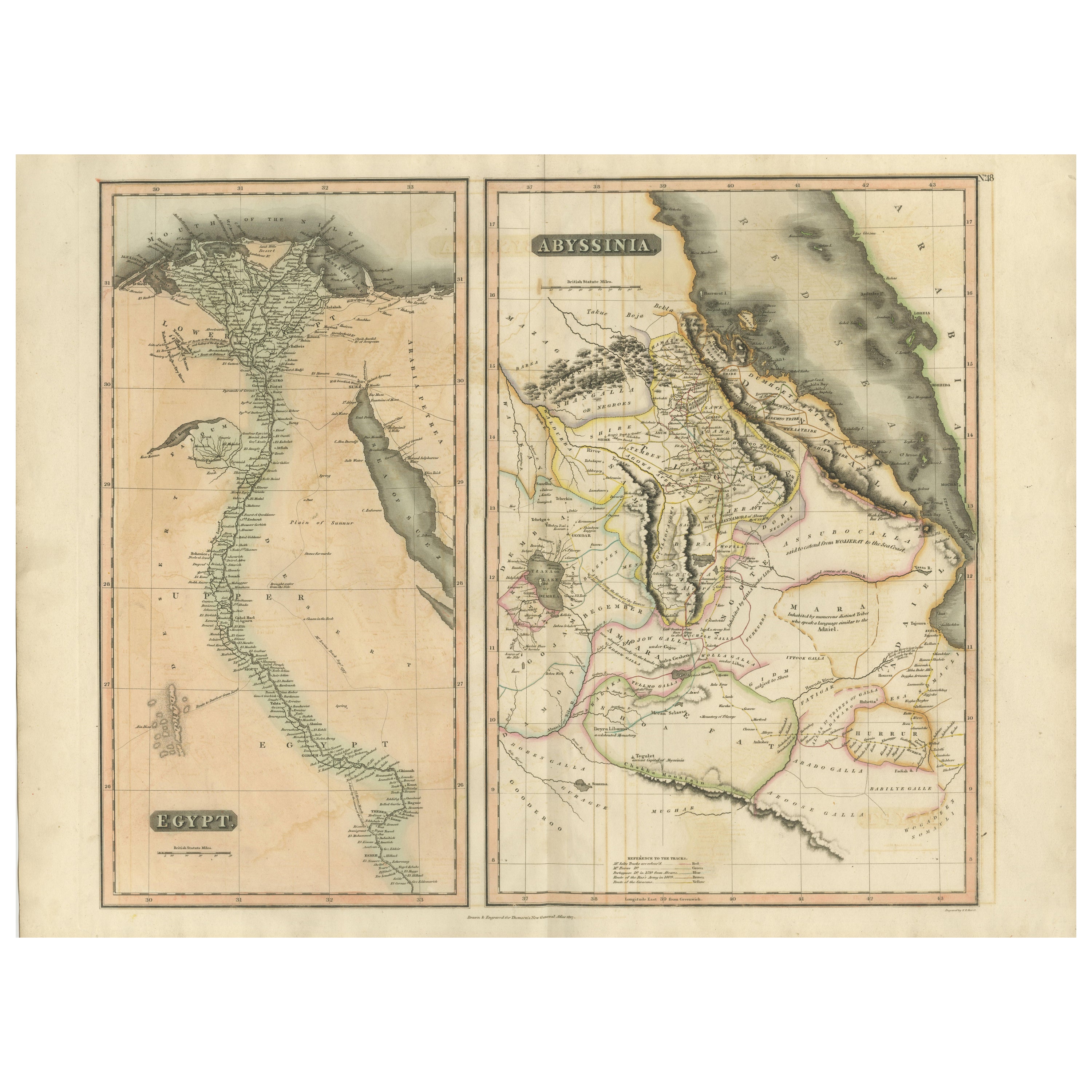
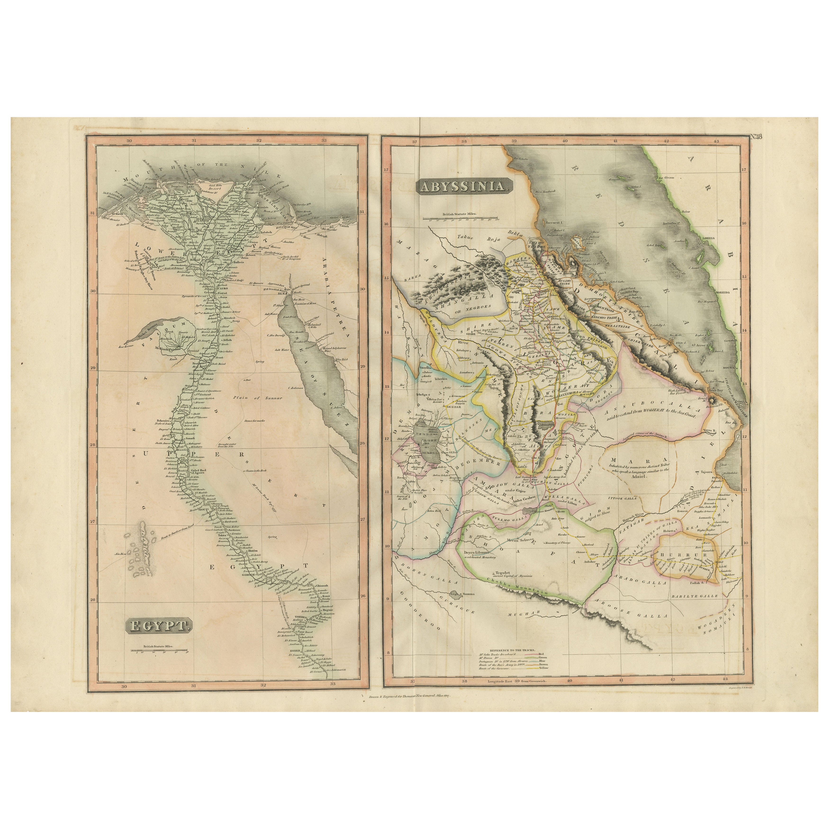
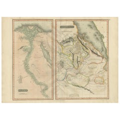
Abyssinia – Original Nile Valley and Horn of Africa Maps, c.1817
Egypt & Abyssinia – Nile Valley and Horn of Africa Maps, c.1817–1820
This refined early 19th-century map composition presents two related geographic views of Northeast Africa: Egypt...
Categoria
Di antiquariato/d’epoca, Anni 1810, Britannico, Mappe
Materiali
Carta
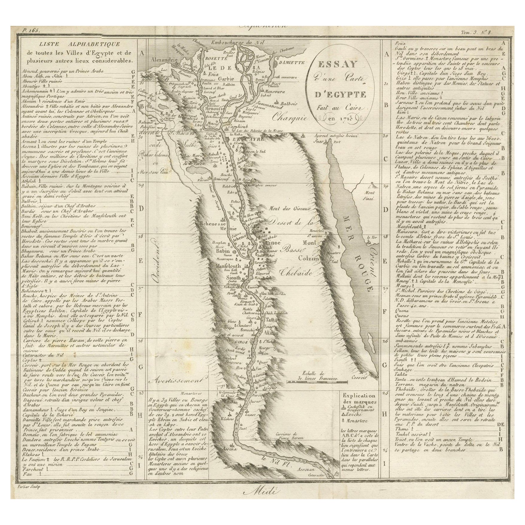
Carta geografica antica dell
Egitto e della Valle del Nilo con indice delle città, 1715
Carta geografica antica dell'Egitto, intitolata "Essay d'une Carte d'Égypte Fait au Caire en 1715".
Questa mappa finemente incisa presenta una rappresentazione dettagliata dell'Egi...
Categoria
Di antiquariato/d’epoca, Inizio XVIII secolo, Francese, Mappe
Materiali
Carta
Egypt and Abyssinia – Nile Valley
Horn of Africa Maps, c.1817–1820
Egypt and Abyssinia – Nile Valley & Horn of Africa Maps, c.1817–1820
This refined early 19th-century paired map presents Egypt and Abyssinia (Ethiopia) as two complementary geograph...
Categoria
Di antiquariato/d’epoca, Anni 1810, Britannico, Mappe
Materiali
Carta
Mappa antica dell
Egitto con inserto dettagliato del Delta del Nilo, 1799 ca.
Mappa antica dell'Egitto con inserto dettagliato del Delta del Nilo, 1799 ca.
Questa mappa antica finemente incisa, intitolata Carte Physique et Politique de l'Égypte, presenta una ...
Categoria
Di antiquariato/d’epoca, Inizio Ottocento, Francese, Mappe
Materiali
Carta

Carta geografica antica del Nilo, dell
Egitto e del Mar Rosso di Bachiene, 1765
Carta geografica antica intitolata "De XIde Landkaart verbeeldende Egypte en de Woestyne der Schelf-Zee (...)". Mappa dell'Egitto biblico e del Mar Rosso. Con cartiglio del titolo, r...
Categoria
Di antiquariato/d’epoca, XVIII secolo, Mappe
Materiali
Carta

Carta geografica antica dell
Antico Egitto raffigurante anche il fiume Nilo e il Mar Rosso, 1845
Carta geografica antica dell'Egitto intitolata "General Karte von Alt Aegypten von H. H.". Brué'. Grande mappa dell'Egitto che raffigura anche il fiume Nilo e il Mar Rosso. Fonte sco...
Categoria
Di antiquariato/d’epoca, XIX secolo, Mappe
Materiali
Carta

Ti potrebbe interessare anche
Mappa della Nubia e dell
Abissinia - Incisione originale di Antonio Zatta - 1784
Questa Mappa della Nubia e dell'Abissinia è un'incisione realizzata da Antonio Zatta a Venezia nel 1784.
Lo stato di conservazione dell'opera d'arte è buono, a parte la carta usurat...
Categoria
Anni 1770, Stampe (paesaggio)
Materiali
Acquaforte

Mappa antica originale dell
antica Grecia - Beozia, Tebe, 1787
Grande mappa dell'Antica Grecia. Mostra la regione della Beozia, compresa Tebe
Disegnato da D. & J. Barbie Du Bocage
Incisione su lastra di rame di P. A. I. P.
Profilo origi...
Categoria
Di antiquariato/d’epoca, Anni 1780, Francese, Altro, Mappe
Materiali
Carta

Mappa antica originale dell
Antica Grecia, Acaia, Corinto, 1786
Grande mappa dell'Antica Grecia. Mostra la regione della Tessaglia, compreso il Monte Olimpo
Disegnato da D. & J. Barbie Du Bocage
Incisione su lastra di rame di P. A. I. P.
...
Categoria
Di antiquariato/d’epoca, Anni 1780, Francese, Altro, Mappe
Materiali
Carta

Africa. Part One. Atlante del secolo antica mappa d
epoca
L'Atlante del Secolo. Africa. Parte Nord-Est".
Mappa antica originale, 1903.
Mappa interna di "Delta del Nilo e Canale di Suez".
Piega centrale come da edizione. Nome e numero dell...
Categoria
Inizio XX secolo, Vittoriano, Altre stampe
Materiali
Litografia

Mappa della Terra Santa "Carte de la Syrie et de l
Egypte" di Pierre Lapie
Di Pierre M. Lapie
Si tratta di una mappa dell'antico Egitto e della Siria risalente agli inizi del XIX secolo e intitolata "Carte de la Syrie et de l'Egypte anciennes/dressée par M. Lapie, Colonel d'E...
Categoria
Anni 1830, Stampe (paesaggio)
Materiali
Incisione

537 € Prezzo promozionale
20% in meno
Mappa antica originale dell
Africa di Dower, 1835 circa
Bella mappa dell'Africa
Disegnato e inciso da J.Dower
Pubblicato da Orr & Smith. C.1835
Senza cornice.
Spedizione gratuita
Categoria
Di antiquariato/d’epoca, Anni 1830, Inglese, Mappe
Materiali
Carta
