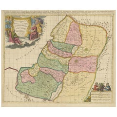
Articoli simili a Antique Holy Land Map, Twelve Tribes of Israel – Covens
Mortier, c.1700


Vuoi altre immagini o video?
Richiedi altre immagini o video al venditore
1 di 10
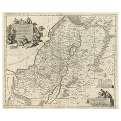
Antique Holy Land Map, Twelve Tribes of Israel – Covens
Mortier, c.1700
1200 €IVA inclusa
Informazioni sull’articolo
Antique Holy Land Map, Twelve Tribes of Israel – Covens
Mortier, c.1700
Description:
This finely engraved early 18th-century map depicts the Holy Land divided according to the Twelve Tribes of Israel. Titled Het Heylige Land verdeeld in de Twaalf Stammen Israëls, it presents biblical Palestine as understood through scripture and classical sources, rather than as a contemporary political geography. The map was published in Amsterdam around 1700 by the renowned firm Covens
Mortier and engraved by Johannes van Luchtenburgh.
The territories of the Twelve Tribes are clearly defined and densely labeled, covering Judaea, Samaria, Galilee, and Transjordan. Major biblical landmarks such as the Jordan River, the Dead Sea, and the Sea of Galilee structure the composition, while surrounding regions including Arabia, Phoenicia, and parts of Egypt provide geographical context. Mountains, rivers, settlements, and place names associated with Old Testament history are carefully engraved throughout, making the map both informative and visually rich.
Decorative engraving enhances the map’s devotional and scholarly character. An elaborate allegorical cartouche at upper left shows biblical figures gathered around the Tablets of the Law, emphasizing the sacred foundation of the subject. At lower right, a seated scholar engaged in study reinforces the map’s role as a tool for biblical learning and interpretation. These elements reflect the strong Protestant interest in biblical geography in Northern Europe around 1700, when such maps were widely used for teaching, study, and display.
Produced to a high standard typical of Dutch mapmaking at the turn of the 18th century, this map balances detailed scholarship with restrained ornament. It was intended not for navigation, but for theological reference and visualizing scripture, and today it remains highly desirable among collectors of Holy Land maps, biblical cartography, and early Dutch engravings.
Condition report:
Good overall condition with a strong, clear impression. Light age toning and minor surface wear consistent with age. Margins present.
Framing tips:
This map frames beautifully in a classic black or dark walnut frame with an ivory or parchment-colored mat to emphasize the fine engraving. A slightly wider mat allows the decorative cartouches to breathe and enhances the map’s presence as a wall piece.
Technique: engraving
Maker: Johannes van Luchtenburgh, Netherlands (published by Covens
Mortier, Amsterdam, c.1700)
- Dimensioni:Altezza: 40 cm (15,75 in)Larghezza: 47 cm (18,51 in)Profondità: 0,2 mm (0,01 in)
- Materiali e tecniche:Carta,Inciso
- Luogo di origine:
- Periodo:
- Data di produzione:circa 1700
- Condizioni:Good overall condition with a strong, clear impression. Light age toning and minor surface wear consistent with age. Margins present.
- Località del venditore:Langweer, NL
- Numero di riferimento:Venditore: BG-14152-11stDibs: LU3054348068952
Informazioni sul venditore
5,0
Venditore riconosciuto
Questi venditori prestigiosi sono leader del settore e rappresentano il massimo in termini di qualità e design.
Venditore Platino
Venditori Premium con valutazione 4.7+ e tempi di risposta entro 24 ore
Fondazione nel 2009
Venditore 1stDibs dal 2017
2811 vendite su 1stDibs
Tempo di risposta standard: 1 ora
- SpedizioneRecupero del preventivo…Spedizione da: Langweer, Paesi Bassi
- Politica di reso
Alcune parti di questa pagina sono state tradotte automaticamente. 1stDibs non può garantire che le traduzioni siano corrette. L’inglese è la lingua predefinita del sito.
Altro da questo venditore
Mostra tuttoAntique French Map of the Holy Land, Twelve Tribes of Israel, c.1750
Antique Holy Land Map, Twelve Tribes of Israel – Robert de Vaugondy, c.1750
Description
This finely engraved and hand-colored map depicts Judea, or the Holy Land, divided according ...
Categoria
Di antiquariato/d’epoca, Metà XVIII secolo, Francese, Mappe
Materiali
Carta
Mappa antica altamente dettagliata della Terra Santa con le 12 tribù di Israel, 1720 ca.
Carta geografica antica intitolata "Heylige Land verdeeld in de Twaalf Stammen Israel (...)".
Mappa altamente dettagliata della Terra Santa divisa nelle 12 tribù di Israel. Con b...
Categoria
Di antiquariato/d’epoca, Anni 1720, Mappe
Materiali
Carta

384 € Prezzo promozionale
20% in meno
Spedizione gratuita
Holy Land Map of the Twelve Tribes of Israel, After Sanson, Paris c.1798
Holy Land, Twelve Tribes of Israel – After Nicolas Sanson, De Vaugondy / Delamarche, c.1798
Description:
Holy Land. De Vaugondy (G. R.), Carte de la Terre des Hébreux ou Israélites,...
Categoria
Di antiquariato/d’epoca, Fine XVIII secolo, Francese, Mappe
Materiali
Carta

Mappa della Terra Santa divisa in 12 tribù, i viaggi di Gesù Cristo, 1700
Carta geografica antica intitolata "Het Heylige Land verdeeld in de Twaalf Stammen Israel (...)".
Mappa decorativa e dettagliata della Terra Santa divisa in 12 Tribù, che mostra ...
Categoria
Di antiquariato/d’epoca, Inizio Settecento, Mappe
Materiali
Carta
392 € Prezzo promozionale
20% in meno
Judaea or Terra Sancta, Twelve Tribes of Israel – Sanson Map, c.1680
Judaea or Terra Sancta, Twelve Tribes of Israel – Sanson Map, c.1680
This antique map depicts Judaea or the Holy Land divided among the Twelve Tribes of Israel, based on biblical ge...
Categoria
Di antiquariato/d’epoca, Fine XVII secolo, Olandese, Mappe
Materiali
Carta
Carta geografica antica della Terra Santa di Van Luchtenburg, 1720 ca.
Mappa antica intitolata "Heylige Land verdeeld in de Twaalf Stammen Israel (...)". Mappa altamente dettagliata della Terra Santa divisa nelle 12 tribù di Israel. Con bel cartiglio de...
Categoria
Di antiquariato/d’epoca, XVIII secolo, Mappe
Materiali
Carta

Ti potrebbe interessare anche
Mappa Terra Santa La Terre Sainte Incisa van Loon Pubblicata N de Fer 1703 Francese
La Terre Sainte, La Terra Santa, Tiree Des Memoires De M.De.La Rue. Par N. de Fer. Geographe de Sa Majeste Catoliq et de Monseigneur le Dauphin. Avec Privil du Roi 1703
Mappa dett...
Categoria
Di antiquariato/d’epoca, Inizio Settecento, Francese, Luigi XIV, Mappe
Materiali
Carta

1657 Carta di Janssonius di Vermandois e Cappelle, Ric. A-004
1657 Mappa di Janssonius di
Vermandois e Cappelle
Ric.a004
Descrizione: Carta geografica antica della Francia intitolata "Descriptio Veromanduorum - Gouvernement de la Cappell...
Categoria
Di antiquariato/d’epoca, XVII secolo, Sconosciuto, Mappe
Materiali
Carta

Mappa olandese del XVII secolo della Terra Santa al tempo di Gesù di Visscher
Di Nicolaus Visscher
Questa dettagliata mappa olandese intitolata "Het Beloofe de Landt Canaan door wandelt van onsen Salichmaecker Iesu Christo, nessens syne Apostelen" di Nicolaes Visscher (1610-1679),...
Categoria
Anni 1660, Stampe e riproduzioni
Materiali
Incisione

Nicolaus VisscherMappa olandese del XVII secolo della Terra Santa al tempo di Gesù di Visscher, 1663
882 € Prezzo promozionale
20% in meno
"Nova Barbariae Descriptio", una mappa del Nord Africa colorata a mano del XVII secolo
Di Johannes Janssonius
Questa attraente mappa del Nord Africa originale del XVII secolo, colorata a mano e intitolata "Nova Barbariae Descriptio" di Johannes Janssonius, fu pubblicata a Parigi nel 1635. Co...
Categoria
Di antiquariato/d’epoca, Metà XVII secolo, Olandese, Mappe
Materiali
Carta

882 € Prezzo promozionale
20% in meno
1714 Henri Chatelain "Nouvelle Carte Des Etatas Du Grand.Duc De Mos Moscovie Eur
Una mappa di Henri Chatelain del 1714, intitolata
"Nouvelle Carte Des Etatas Du Grand Duc De Moscovie En Europe".
Ricb001
Henri-Abraham Chatelain (1684-1743) era un pastore ugo...
Categoria
Di antiquariato/d’epoca, Inizio XVIII secolo, Olandese, Mappe
Materiali
Carta

1640 Carta di Joan Bleau intitolata "Diocecese de rheims et le pais de rethel, " Eic.a011
1640 Mappa di Joan Bleau intitolata
"Diocecese di Reims e il paese di Rethel".
Ric.a011
OAN BLAEU
Diocecese di Reims e il paese di Rethel.
Incisione colorata a mano, 1...
Categoria
Di antiquariato/d’epoca, XVII secolo, Olandese, Mappe
Materiali
Carta
