Articoli simili a Antique Map of the Peloponnese – Peloponnesus, Morea, by Cluver, ca.1697

Vuoi altre immagini o video?
Richiedi altre immagini o video al venditore
1 di 9
Antique Map of the Peloponnese – Peloponnesus, Morea, by Cluver, ca.1697
470 €IVA inclusa
Informazioni sull’articolo
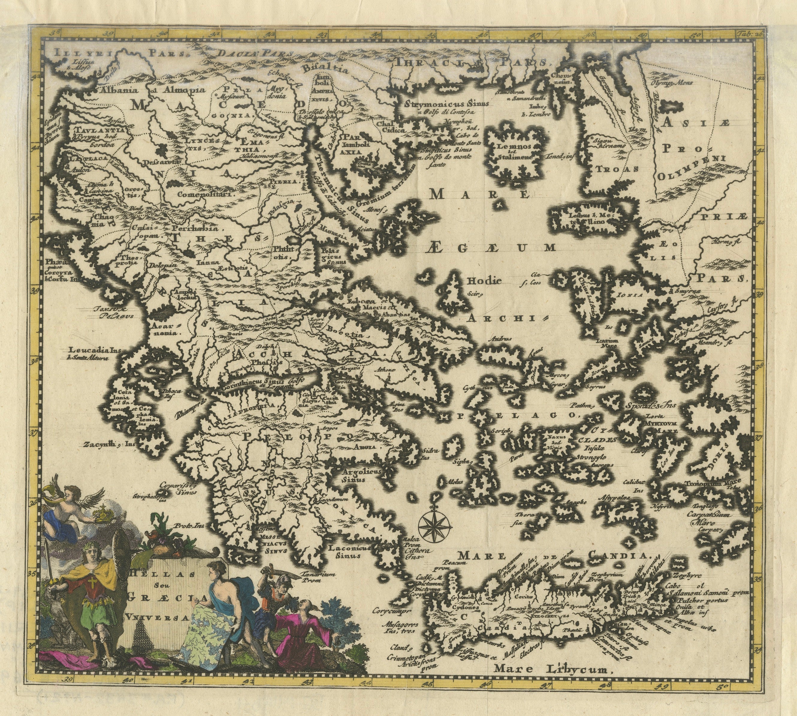
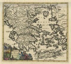
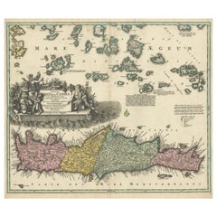
Hellas seu Graecia Universa is a finely detailed late-17th-century map of Greece and the Aegean world, issued by Philipp Cluver around 1697 (possibly 1694). The map was published in Introductio in Universam Geographiam, Cluver’s influential geographical handbook that shaped European understanding of classical and contemporary geography for more than a century.
The map presents a comprehensive view of the Greek mainland, the Peloponnese, Crete (Candia), and the densely articulated island world of the Aegean Sea. Ancient regional names—such as Thessalia, Macedonia, Epirus, Achaia, and Laconia—are prominently shown, reflecting Cluver’s pioneering approach of combining classical sources with modern geographic knowledge. This synthesis made his work particularly valued by scholars of antiquity, historians, and educated collectors throughout Europe.
Cartographically, the engraving is rich and precise, with deeply indented coastlines, clearly engraved mountain ranges, and an intricate hydrographic network. The Aegean archipelago is rendered with exceptional density, giving the map strong visual rhythm and decorative appeal. A compass rose provides orientation, while the allegorical title cartouche—populated by classical figures—reinforces the learned, humanist character of the work and anchors it firmly within the intellectual traditions of the Dutch Golden Age of cartography.
This example is attractively hand colored, adding warmth and depth to the engraved lines without obscuring detail. Issued in numerous editions across major European publishing centers such as Amsterdam, Nuremberg, and London, Cluver’s Introductio became one of the most widely disseminated geographic works of the 17th century, and maps such as this were central to its success.
Today, Hellas seu Graecia Universa is appreciated both as a scholarly map of classical Greece and as a highly decorative wall piece. It appeals equally to collectors of antique maps, classicists, and interior designers seeking an image that conveys learning, history, and visual complexity.
Condition report: Generally good for a 17th-century engraving. Light age toning and minor handling wear, consistent with age. Plate mark visible.
Framing tips: A dark walnut or ebonized frame with a warm ivory or parchment mat emphasizes the engraving and hand color; alternatively, an antique gold frame with a narrow profile enhances the classical character of the cartouche.
Technique: Copper engraving with hand color
Maker: Philipp Cluver, published in Europe, ca. 1697
- Dimensioni:Altezza: 22,5 cm (8,86 in)Larghezza: 27,3 cm (10,75 in)Profondità: 0,2 mm (0,01 in)
- Materiali e tecniche:Carta,Inciso
- Luogo di origine:
- Periodo:Fine XVII secolo
- Data di produzione:circa 1697
- Condizioni:Condition report: Generally good for a 17th-century engraving. Light age toning and minor handling wear, consistent with age. Plate mark visible.
- Località del venditore:Langweer, NL
- Numero di riferimento:Venditore: BG-14196-21stDibs: LU3054348065792
Informazioni sul venditore
5,0
Venditore riconosciuto
Questi venditori prestigiosi sono leader del settore e rappresentano il massimo in termini di qualità e design.
Venditore Platino
Venditori Premium con valutazione 4.7+ e tempi di risposta entro 24 ore
Fondazione nel 2009
Venditore 1stDibs dal 2017
2811 vendite su 1stDibs
Tempo di risposta standard: 1 ora
- SpedizioneRecupero del preventivo…Spedizione da: Langweer, Paesi Bassi
- Politica di reso
Alcune parti di questa pagina sono state tradotte automaticamente. 1stDibs non può garantire che le traduzioni siano corrette. L’inglese è la lingua predefinita del sito.
Altro da questo venditore
Mostra tuttoAntique Classical Greece Map – Aegean Sea
Crete, ca.1697
Hellas seu Graecia Universa is a finely detailed late-17th-century map of Greece and the Aegean world, issued by Philipp Cluver around 1697 (possibly 1694). The map was published in ...
Categoria
Di antiquariato/d’epoca, Fine XVII secolo, Mappe
Materiali
Carta
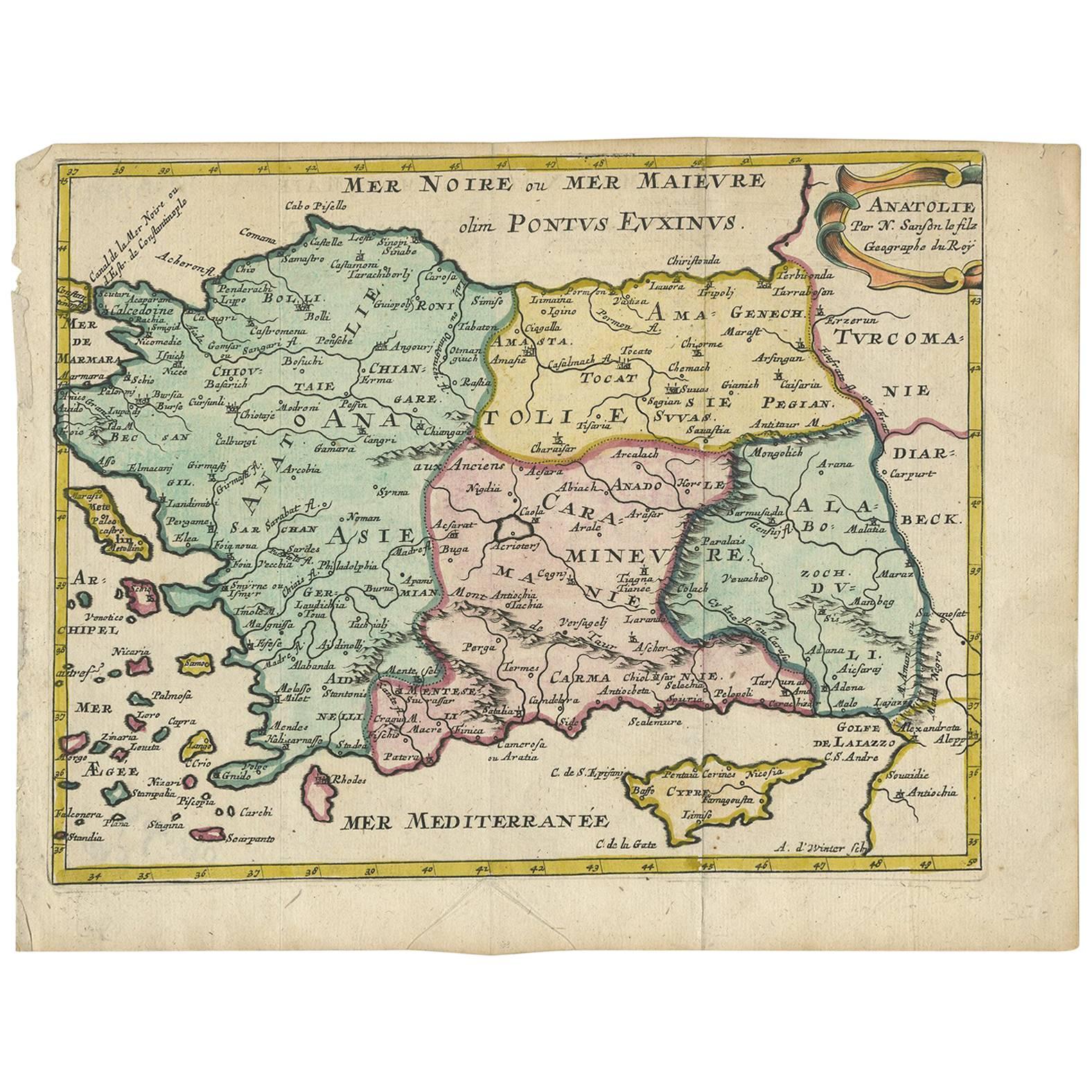
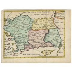
Carta geografica antica della Turchia con le isole di Cipro e della Grecia di N. Sanson, 1652 ca.
Carta geografica antica della Turchia, dell'Anatolia con Cipro e le isole della Grecia. Attraente cartiglio con titolo a volute nell'angolo superiore destro. Verso vuoto.
Categoria
Di antiquariato/d’epoca, Metà XVII secolo, Mappe
Materiali
Carta
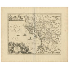
Carta geografica antica dell
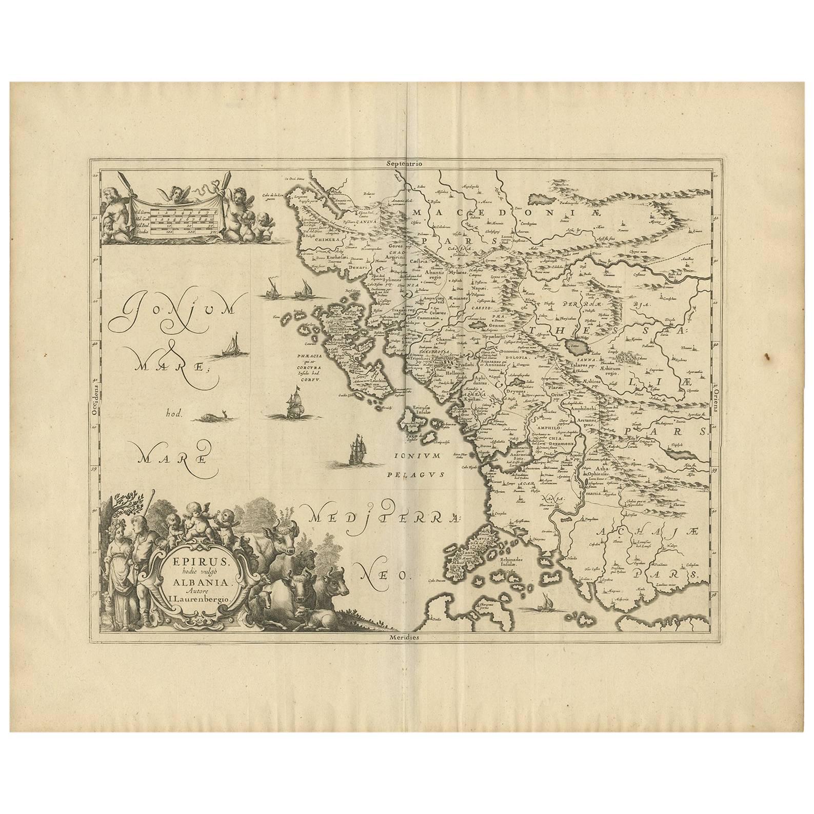
Epiro
Albania, Grecia
di J. Janssonius, 1650 ca.
Questa mappa copre la costa nord-occidentale della Grecia e parte dell'attuale Albania. La mappa è stata disegnata da Johannes Wilhelm Laurenberg, un matematico e storico che ha prod...
Categoria
Di antiquariato/d’epoca, Metà XVII secolo, Mappe
Materiali
Carta
670 €
Spedizione gratuita
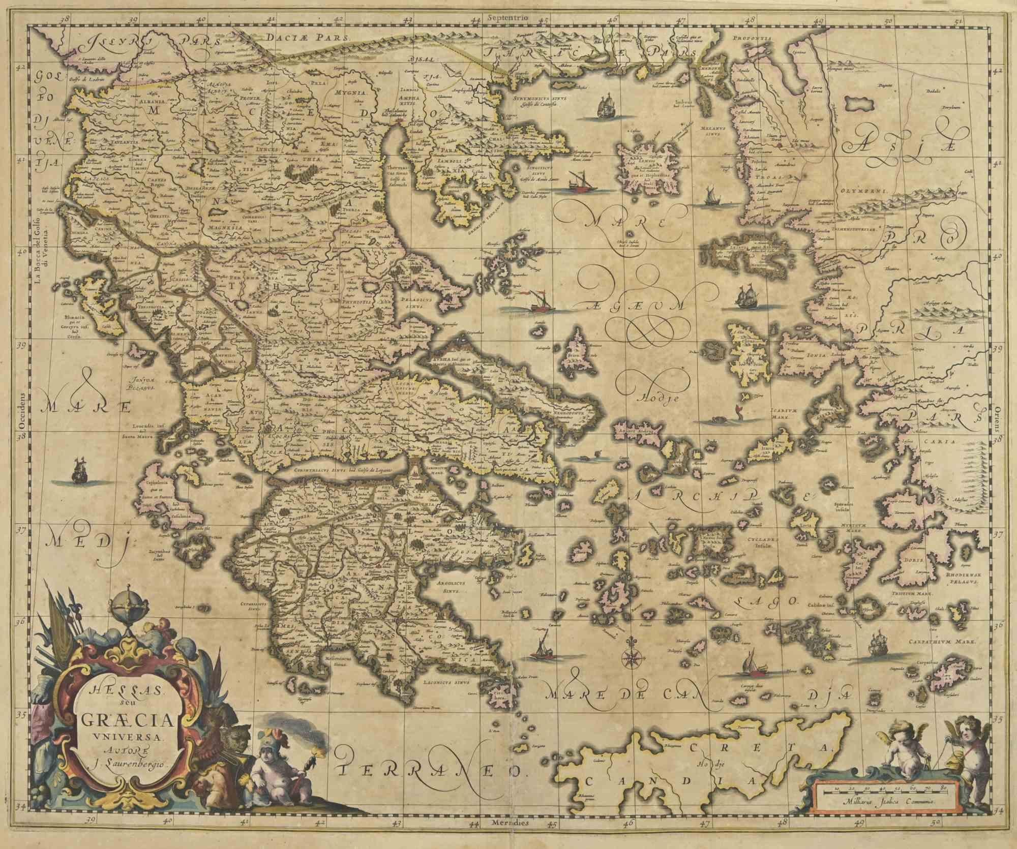
Carta geografica antica della Grecia di Allard (1698 ca.)
Mappa antica intitolata "Hellas seu Graecia Universa" Mappa dettagliata della Grecia, con Creta, le isole dell'Egeo e parte della Turchia. Con due cartigli, rosa dei venti e scala. C...
Categoria
Di antiquariato/d’epoca, Fine XVII secolo, Mappe
Materiali
Carta

784 € Prezzo promozionale
20% in meno
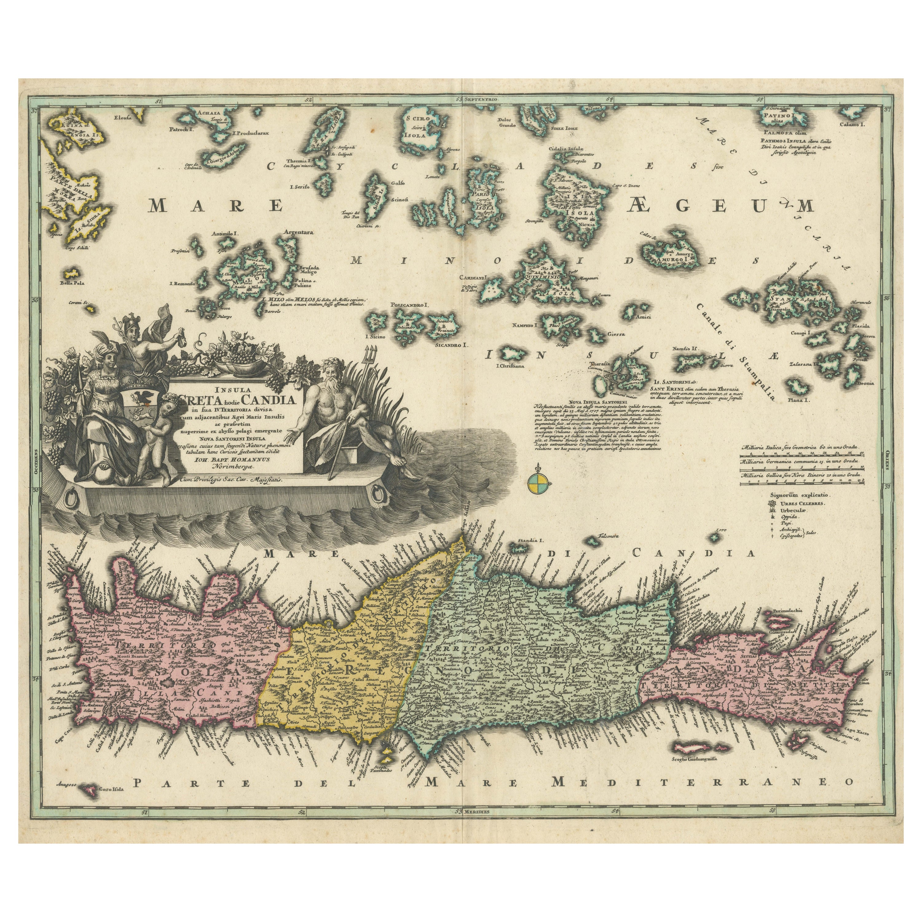
Mappa di Creta 1749 - Incisione di Homann Heirs di Candia con le isole del Mar Egeo
Crete Map 1749 – Homann Heirs Engraving of Candia with Aegean Islands
This fine 1749 map titled 'Insula Creta hodie Candia' presents an 18th-century cartographic portrait of the isl...
Categoria
Di antiquariato/d’epoca, Anni 1740, Tedesco, Mappe
Materiali
Carta
Carta geografica antica dell
Italia meridionale di Janssonius, 1650 ca.
"Carta geografica antica intitolata 'Itala nam tellus Graecia Maior erat Ovidio. IV. Fastor. Haec Italiae pars nunc primum de prica aerugine est abstersa (...)". Bellissima mappa del...
Categoria
Di antiquariato/d’epoca, XVII secolo, Mappe
Materiali
Carta

592 € Prezzo promozionale
20% in meno
Ti potrebbe interessare anche
Carta geografica antica - Mappa della Grecia - Incisione di Johannes Janssonius - Anni 1650
Di Johannes Janssonius
Mappa antica della Grecia - Graecia Vniversa è una mappa antica realizzata nel 1650 da Johannes Janssonius (1588-1664).
La mappa è un'acquaforte colorata a mano, con acquerello coe...
Categoria
Anni 1650, Moderno, Stampe figurative
Materiali
Acquaforte

Grecia meridionale: Una grande mappa colorata a mano del XVII secolo di Sanson e Jaillot
Di Nicholas Sanson d
Abbeville
Questa grande mappa originale incisa a mano su rame della Grecia meridionale e della Penisola Pelopponese, intitolata "La Moree Et Les Isles De Zante, Cefalonie, Ste. Marie, Cerigo &...
Categoria
Anni 1690, Stampe (paesaggio)
Materiali
Incisione

1367 € Prezzo promozionale
20% in meno
Mappa della Grecia - Incisione originale di Antonio Zatta - XVIII secolo
Questa mappa della Grecia è un'incisione realizzata da Antonio Zatta, cartografo, editore e tipografo.
Lo stato di conservazione dell'opera d'arte è buono, ad eccezione della carta ...
Categoria
Anni 1780, Stampe figurative
Materiali
Acquaforte

Carta geografica antica - Macedonia - Acquaforte di Johannes Janssonius - 1650
Di Johannes Janssonius
La Macedonia è un'antica mappa realizzata nel 1650 da Johannes Janssonius (1588-1664).
La mappa è un'acquaforte colorata a mano, con acquerello coevo.
Buone condizioni con leggero ...
Categoria
Anni 1650, Moderno, Stampe figurative
Materiali
Acquaforte

Carta geografica antica - Mar Di Athiopia - Acquaforte di Johannes Janssonius - 1650
Di Johannes Janssonius
Mappa antica - Marli Di Athiopia è una mappa antica realizzata nel 1650 da Johannes Janssonius (1588-1664).
La mappa è un'acquaforte colorata a mano, con acquerello coevo.
Buone co...
Categoria
Anni 1650, Moderno, Stampe figurative
Materiali
Acquaforte

Grecia meridionale: Una grande mappa colorata a mano del XVII secolo di Sanson e Jaillot
Di Nicolas Sanson
Questa grande mappa originale incisa a mano su rame della Grecia meridionale e della Penisola Pelopponese, intitolata "La Moree Et Les Isles De Zante, Cefalonie, Ste. Marie, Cerigo &...
Categoria
Di antiquariato/d’epoca, Anni 1690, Francese, Mappe
Materiali
Carta

1367 € Prezzo promozionale
20% in meno