Articoli simili a Holy Land Map of the Twelve Tribes of Israel, After Sanson, Paris c.1798


Vuoi altre immagini o video?
Richiedi altre immagini o video al venditore
1 di 9
Holy Land Map of the Twelve Tribes of Israel, After Sanson, Paris c.1798
480 €IVA inclusa
Informazioni sull’articolo
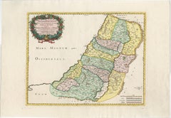
Holy Land, Twelve Tribes of Israel – After Nicolas Sanson, De Vaugondy / Delamarche, c.1798
Description:
Holy Land. De Vaugondy (G. R.), Carte de la Terre des Hébreux ou Israélites, partagée selon l’Ordre de Dieu aux Douze Tribus descendantes des Douze Fils de Jacob. Paris, published by Charles-François Delamarche, circa 1798.
Large engraved biblical map of the Holy Land showing the division of the land among the Twelve Tribes of Israel, based on the cartography of Nicolas Sanson (1600–1667). The map depicts the territories west and east of the River Jordan, including Judah, Benjamin, Ephraim, Manasseh, Dan, Issachar, Zebulon, Asher, Naphtali, Reuben, and Gad, with cities, deserts, mountain ranges, and waterways carefully delineated.
This late 18th-century issue was published by Delamarche, successor to the Sanson and De Vaugondy cartographic tradition, and reflects continued European interest in biblical geography. The map is engraved on copper and finished with contemporary outline hand-coloring to distinguish the tribal boundaries. Decorative elements include an elaborate baroque cartouche and an inset map illustrating the lands east of the Jordan.
Condition:
Fair condition. Some creasing and surface wear. Old worming affecting the central fold, repaired from the verso. Tape and old reinforcements on the back. Light to moderate overall toning. No major loss to the engraved image.
Dimensions: 490 × 690 mm (approx. 19.3 × 27.2 inches)
Technique: Copper engraving with contemporary outline hand-coloring
Maker: After Nicolas Sanson; published by Charles-François Delamarche, Paris, circa 1798
- Dimensioni:Altezza: 49 cm (19,3 in)Larghezza: 69 cm (27,17 in)Profondità: 0,2 mm (0,01 in)
- Materiali e tecniche:Carta,Inciso
- Luogo di origine:
- Periodo:
- Data di produzione:circa 1798
- Condizioni:Riparato: Old worming affecting the central fold, repaired from the verso. Tape and old reinforcements on the back. Fair condition. Some creasing and surface wear. Old worming affecting the central fold, repaired from the verso. Tape and old reinforcements on the back. Light to moderate overall toning. No major loss to the engraved image.
- Località del venditore:Langweer, NL
- Numero di riferimento:Venditore: BG-14152-31stDibs: LU3054348101602
Informazioni sul venditore
5,0
Venditore riconosciuto
Questi venditori prestigiosi sono leader del settore e rappresentano il massimo in termini di qualità e design.
Venditore Platino
Venditori Premium con valutazione 4.7+ e tempi di risposta entro 24 ore
Fondazione nel 2009
Venditore 1stDibs dal 2017
2813 vendite su 1stDibs
Tempo di risposta standard: 1 ora
- SpedizioneRecupero del preventivo…Spedizione da: Langweer, Paesi Bassi
- Politica di reso
Alcune parti di questa pagina sono state tradotte automaticamente. 1stDibs non può garantire che le traduzioni siano corrette. L’inglese è la lingua predefinita del sito.
Altro da questo venditore
Mostra tuttoAntique French Map of the Holy Land, Twelve Tribes of Israel, c.1750
Antique Holy Land Map, Twelve Tribes of Israel – Robert de Vaugondy, c.1750
Description
This finely engraved and hand-colored map depicts Judea, or the Holy Land, divided according ...
Categoria
Di antiquariato/d’epoca, Metà XVIII secolo, Francese, Mappe
Materiali
Carta
Antique Holy Land Map, Twelve Tribes of Israel – Covens
Mortier, c.1700
Antique Holy Land Map, Twelve Tribes of Israel – Covens
Mortier, c.1700
Description:
This finely engraved early 18th-century map depicts the Holy Land divided according to the...
Categoria
Di antiquariato/d’epoca, Inizio XVIII secolo, Francese, Mappe
Materiali
Carta

Mappa della Terra Santa del 1718 - Dodici tribù, sei province, colorata a mano, Mappa antica
Titolo: Terra Sancta in XII olim Tribus nunc VI Provincias Dispertita
Cartografo: Christoph Weigel il Vecchio (1654-1725)
Editore: Johann Ernst Adelbulner
Luogo e anno di pubbl...
Categoria
Di antiquariato/d’epoca, Anni 1710, Tedesco, Mappe
Materiali
Carta

Judaea or Terra Sancta, Twelve Tribes of Israel – Sanson Map, c.1680
Judaea or Terra Sancta, Twelve Tribes of Israel – Sanson Map, c.1680
This antique map depicts Judaea or the Holy Land divided among the Twelve Tribes of Israel, based on biblical ge...
Categoria
Di antiquariato/d’epoca, Fine XVII secolo, Olandese, Mappe
Materiali
Carta
Mappa antica altamente dettagliata della Terra Santa con le 12 tribù di Israel, 1720 ca.
Carta geografica antica intitolata "Heylige Land verdeeld in de Twaalf Stammen Israel (...)".
Mappa altamente dettagliata della Terra Santa divisa nelle 12 tribù di Israel. Con b...
Categoria
Di antiquariato/d’epoca, Anni 1720, Mappe
Materiali
Carta

384 € Prezzo promozionale
20% in meno
Spedizione gratuita
Holy Land Map of the Twelve Tribes of Israel – Sanson, Hand Colored, 1696
Holy Land Map of the Twelve Tribes of Israel – Sanson, Hand Colored, 1696
Description:
This impressive and richly hand-colored map of the Holy Land depicts the biblical territories ...
Categoria
Di antiquariato/d’epoca, Fine XVII secolo, Francese, Mappe
Materiali
Carta
Ti potrebbe interessare anche
Mappa Terra Santa La Terre Sainte Incisa van Loon Pubblicata N de Fer 1703 Francese
La Terre Sainte, La Terra Santa, Tiree Des Memoires De M.De.La Rue. Par N. de Fer. Geographe de Sa Majeste Catoliq et de Monseigneur le Dauphin. Avec Privil du Roi 1703
Mappa dett...
Categoria
Di antiquariato/d’epoca, Inizio Settecento, Francese, Luigi XIV, Mappe
Materiali
Carta

Antique French Map of Asia Including China Indoneseia India, 1783
Mappa dell'Asia molto bella. 1783 Dedie au Roy.
Informazioni aggiuntive:
Paese di produzione: Europa
Periodo: XVIII secolo Qing (1661 - 1912)
Condit: Condizioni generali B (buon usa...
Categoria
Di antiquariato/d’epoca, XVIII secolo, Europeo, Mappe
Materiali
Carta

421 € Prezzo promozionale
40% in meno
Antica mappa pieghevole della Francia del 1765, Bordeau, ecc.
Strada delle Carosse de Bordeaux, part de Paris tous les Mardis a 11 matin. a et pafse 1765 è una mappa completa con due percorsi attraverso la Francia vinicola che parte da Parigi...
Categoria
Anni 1760, Altro stile artistico, Stampe (paesaggio)
Materiali
Acquaforte

Grecia meridionale: Una grande mappa colorata a mano del XVII secolo di Sanson e Jaillot
Di Nicolas Sanson
Questa grande mappa originale incisa a mano su rame della Grecia meridionale e della Penisola Pelopponese, intitolata "La Moree Et Les Isles De Zante, Cefalonie, Ste. Marie, Cerigo &...
Categoria
Di antiquariato/d’epoca, Anni 1690, Francese, Mappe
Materiali
Carta

1367 € Prezzo promozionale
20% in meno
Mappa del Regno di Sardegna e di parte del Regno di Genova, Roma
Di Giovanni Maria Cassini
Mappa del XVIII secolo dell'incisore italiano Giovanni Maria Cassini (Italia 1745-1824). Mappa di parte del Regno di Sardegna e di parte del Regno di Genova: Roma. Si tratta di una s...
Categoria
Di antiquariato/d’epoca, XVIII secolo, Italiano, Mappe
Materiali
Carta

688 € Prezzo promozionale
36% in meno
Mappa Homann del Mar Nero, della Turchia e dell
Asia Minore colorata a mano del XVIII secolo
Di Johann Baptist Homann
Un'attraente mappa originale del Mar Nero e della Turchia colorata a mano dell'inizio del XVIII secolo intitolata "Carte de L'Asie Minevre ou de la Natolie et du Pont Evxin Tiree des...
Categoria
Di antiquariato/d’epoca, Inizio XVIII secolo, Tedesco, Mappe
Materiali
Carta

605 € Prezzo promozionale
20% in meno