Articoli simili a Judaea or Terra Sancta, Twelve Tribes of Israel – Sanson Map, c.1680


Vuoi altre immagini o video?
Richiedi altre immagini o video al venditore
1 di 9
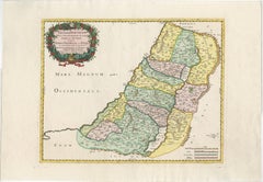
Judaea or Terra Sancta, Twelve Tribes of Israel – Sanson Map, c.1680
790 €IVA inclusa
Informazioni sull’articolo
Judaea or Terra Sancta, Twelve Tribes of Israel – Sanson Map, c.1680
This antique map depicts Judaea or the Holy Land divided among the Twelve Tribes of Israel, based on biblical geography as described in the Old Testament. Titled Judæa seu Terra Sancta quæ Hebræorum sive Israelitarum Terra, in suas duodecim tribus divisa, the map presents the tribal territories both west and east of the River Jordan, including Judah, Benjamin, Simeon, Ephraim, Manasseh, Issachar, Zebulon, Asher, Naphtali, Reuben, and Gad. Major cities, deserts, mountain ranges, and waterways are carefully delineated, with the Dead Sea, River Jordan, and Mediterranean coast prominently shown.
The map was engraved after the work of Guillaume Sanson (1633–1703), son of Nicolas Sanson, the founder of French scientific cartography. This example was issued in Amsterdam around 1680, reflecting the continued popularity of Sanson’s biblical cartography in the Dutch Republic. The geography follows biblical tradition rather than modern surveying, emphasizing scriptural divisions and historical interpretation.
Decoratively, the map is distinguished by a large allegorical cartouche in the upper left, featuring classical figures presenting the title within drapery, as well as an additional decorative vignette in the lower right. The map is finely engraved on copper and finished with contemporary wash coloring to differentiate the tribal boundaries, lending both clarity and visual appeal. The combination of detailed engraving, rich iconography, and restrained coloring makes this an attractive example of late 17th-century Holy Land cartography.
This map is well suited to collectors of early biblical maps, Sanson family cartography, or 17th-century engraved maps of the Holy Land. It also works well as a decorative interior piece, particularly in a study, library, or gallery setting.
Condition:
Fair to good condition. Engraved map with original horizontal and vertical folds as issued. Occasional marginal closed tears, some light creasing, and general age-related toning. No major loss to the engraved image.
Framing tips:
This map frames well with a warm off-white or light parchment mat to complement the period paper tone. A dark wood or gilt frame enhances the allegorical cartouche and reinforces the late 17th-century character. UV-protective glazing is recommended.
Technique: Copper engraving with contemporary wash coloring
Maker: Guillaume Sanson, Amsterdam, circa 1680
- Dimensioni:Altezza: 48,5 cm (19,1 in)Larghezza: 58 cm (22,84 in)Profondità: 0,2 mm (0,01 in)
- Materiali e tecniche:Carta,Inciso
- Luogo di origine:
- Periodo:Fine XVII secolo
- Data di produzione:circa 1680
- Condizioni:Fair to good condition. Engraved map with original horizontal and vertical folds as issued. Occasional marginal closed tears, some light creasing, and general age-related toning. No major loss to the engraved image.
- Località del venditore:Langweer, NL
- Numero di riferimento:Venditore: BG-14153-11stDibs: LU3054348101662
Informazioni sul venditore
5,0
Venditore riconosciuto
Questi venditori prestigiosi sono leader del settore e rappresentano il massimo in termini di qualità e design.
Venditore Platino
Venditori Premium con valutazione 4.7+ e tempi di risposta entro 24 ore
Fondazione nel 2009
Venditore 1stDibs dal 2017
2811 vendite su 1stDibs
Tempo di risposta standard: 1 ora
- SpedizioneRecupero del preventivo…Spedizione da: Langweer, Paesi Bassi
- Politica di reso
Alcune parti di questa pagina sono state tradotte automaticamente. 1stDibs non può garantire che le traduzioni siano corrette. L’inglese è la lingua predefinita del sito.
Altro da questo venditore
Mostra tuttoHoly Land Map of the Twelve Tribes of Israel, After Sanson, Paris c.1798
Holy Land, Twelve Tribes of Israel – After Nicolas Sanson, De Vaugondy / Delamarche, c.1798
Description:
Holy Land. De Vaugondy (G. R.), Carte de la Terre des Hébreux ou Israélites,...
Categoria
Di antiquariato/d’epoca, Fine XVIII secolo, Francese, Mappe
Materiali
Carta

Antique Holy Land Map, Twelve Tribes of Israel – Covens
Mortier, c.1700
Antique Holy Land Map, Twelve Tribes of Israel – Covens
Mortier, c.1700
Description:
This finely engraved early 18th-century map depicts the Holy Land divided according to the...
Categoria
Di antiquariato/d’epoca, Inizio XVIII secolo, Francese, Mappe
Materiali
Carta

Mappa colorata a mano della Terra Santa divisa tra le dodici tribù, 1720 ca.
Mappa colorata a mano della Terra Santa divisa tra le dodici tribù, 1720 ca.
Questa splendida mappa antica, intitolata "Iudaea seu Palaestina ob Sacratissima Redemtoris Vestigia Hod...
Categoria
Di antiquariato/d’epoca, Inizio XVIII secolo, Tedesco, Mappe
Materiali
Carta

Mappa antica della Terra Santa e del Paradiso - Mappa Terrae Canaan, 1720 ca.
Mappa antica della Terra Santa e del Paradiso di François Halma, 1720 ca.
Bellissima mappa del Medio Oriente dei primi del XVIII secolo, colorata a mano, che si estende dal Mar Medi...
Categoria
Di antiquariato/d’epoca, Inizio XVIII secolo, Olandese, Mappe
Materiali
Carta

Antique French Map of the Holy Land, Twelve Tribes of Israel, c.1750
Antique Holy Land Map, Twelve Tribes of Israel – Robert de Vaugondy, c.1750
Description
This finely engraved and hand-colored map depicts Judea, or the Holy Land, divided according ...
Categoria
Di antiquariato/d’epoca, Metà XVIII secolo, Francese, Mappe
Materiali
Carta
Holy Land Map of the Twelve Tribes of Israel – Sanson, Hand Colored, 1696
Holy Land Map of the Twelve Tribes of Israel – Sanson, Hand Colored, 1696
Description:
This impressive and richly hand-colored map of the Holy Land depicts the biblical territories ...
Categoria
Di antiquariato/d’epoca, Fine XVII secolo, Francese, Mappe
Materiali
Carta
Ti potrebbe interessare anche
Grecia meridionale: Una grande mappa colorata a mano del XVII secolo di Sanson e Jaillot
Di Nicholas Sanson d
Abbeville
Questa grande mappa originale incisa a mano su rame della Grecia meridionale e della Penisola Pelopponese, intitolata "La Moree Et Les Isles De Zante, Cefalonie, Ste. Marie, Cerigo &...
Categoria
Anni 1690, Stampe (paesaggio)
Materiali
Incisione

1367 € Prezzo promozionale
20% in meno
Grecia meridionale: Una grande mappa colorata a mano del XVII secolo di Sanson e Jaillot
Di Nicolas Sanson
Questa grande mappa originale incisa a mano su rame della Grecia meridionale e della Penisola Pelopponese, intitolata "La Moree Et Les Isles De Zante, Cefalonie, Ste. Marie, Cerigo &...
Categoria
Di antiquariato/d’epoca, Anni 1690, Francese, Mappe
Materiali
Carta

1367 € Prezzo promozionale
20% in meno
"Nova Barbariae Descriptio", una mappa del Nord Africa colorata a mano del XVII secolo
Di Johannes Janssonius
Questa attraente mappa del Nord Africa originale del XVII secolo, colorata a mano e intitolata "Nova Barbariae Descriptio" di Johannes Janssonius, fu pubblicata a Parigi nel 1635. Co...
Categoria
Di antiquariato/d’epoca, Metà XVII secolo, Olandese, Mappe
Materiali
Carta

882 € Prezzo promozionale
20% in meno
Mappa Terra Santa La Terre Sainte Incisa van Loon Pubblicata N de Fer 1703 Francese
La Terre Sainte, La Terra Santa, Tiree Des Memoires De M.De.La Rue. Par N. de Fer. Geographe de Sa Majeste Catoliq et de Monseigneur le Dauphin. Avec Privil du Roi 1703
Mappa dett...
Categoria
Di antiquariato/d’epoca, Inizio Settecento, Francese, Luigi XIV, Mappe
Materiali
Carta

Carta geografica antica - Mar Di Athiopia - Acquaforte di Johannes Janssonius - 1650
Di Johannes Janssonius
Mappa antica - Marli Di Athiopia è una mappa antica realizzata nel 1650 da Johannes Janssonius (1588-1664).
La mappa è un'acquaforte colorata a mano, con acquerello coevo.
Buone co...
Categoria
Anni 1650, Moderno, Stampe figurative
Materiali
Acquaforte

Mappa del Regno di Sardegna e di parte del Regno di Genova, Roma
Di Giovanni Maria Cassini
Mappa del XVIII secolo dell'incisore italiano Giovanni Maria Cassini (Italia 1745-1824). Mappa di parte del Regno di Sardegna e di parte del Regno di Genova: Roma. Si tratta di una s...
Categoria
Di antiquariato/d’epoca, XVIII secolo, Italiano, Mappe
Materiali
Carta

688 € Prezzo promozionale
36% in meno