Articoli simili a Monomotapa Empire Map – East Africa, French Cartography, c.1740

Vuoi altre immagini o video?
Richiedi altre immagini o video al venditore
1 di 10
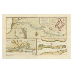
Monomotapa Empire Map – East Africa, French Cartography, c.1740
570 €IVA inclusa
Informazioni sull’articolo
Monomotapa Empire Map – East Africa, French Cartography, c.1740
This important French map depicts the legendary Empire of Monomotapa and the surrounding regions of southeastern Africa, encompassing present-day Mozambique, Zimbabwe, and inland southern Africa. The map is titled “Empire du Monomotapa et États Voisins” and was engraved after the work of Guillaume Delisle and other French authorities. It was published in Paris around 1740 as part of the official French geographical corpus.
The map reflects early European attempts to understand and delineate the political geography of interior southern Africa, a region long associated in European thought with gold wealth, powerful inland kingdoms, and ancient trade networks. Monomotapa, often linked by Europeans to biblical Ophir, appears prominently, alongside neighboring states, river systems, mountain ranges, and coastal trading centers connected to the Indian Ocean world.
The Zambezi river system is carefully traced inland, linking coastal Mozambique to the interior, while named kingdoms, territories, and ethnographic regions are distinguished through subtle hand coloring. Coastal areas show Portuguese trading posts and forts, underscoring the strategic and commercial rivalry between European powers in East Africa. The cartography blends empirical coastal knowledge with speculative interior geography, making the map a compelling document of 18th-century European geographic thought.
Decoratively, the map balances clarity and elegance. A large engraved title cartouche anchors the lower right, while the coastline, rivers, and political boundaries are highlighted with contemporary hand color. Latitude and longitude markings provide a scientific framework, reflecting the influence of Delisle’s reformist cartographic approach, which emphasized accuracy and critical source comparison.
This map is particularly desirable for collectors of African cartography, early colonial history, and maps illustrating the transition from myth-based geography to empirically grounded mapping. It also serves as a powerful contextual counterpart to more focused coastal and harbor charts of Mozambique and the Indian Ocean.
Condition report
Good condition overall. Light age toning consistent with period. Central vertical fold as issued. Minor scattered spots and light surface marks. Original hand coloring. Plate mark visible. Margins intact.
Framing tips
This map benefits from a generous off-white or light sand-colored mat to visually separate the detailed interior geography from the frame. A medium to dark wood frame complements the hand coloring and gives the piece a scholarly, museum-style presence. Particularly effective when displayed as the central piece in an East Africa cartographic grouping.
Technique: Copper engraving with contemporary hand color
Maker: After Guillaume Delisle, France, c.1740
- Dimensioni:Altezza: 24,5 cm (9,65 in)Larghezza: 32,5 cm (12,8 in)Profondità: 0,2 mm (0,01 in)
- Materiali e tecniche:Carta,Inciso
- Luogo di origine:
- Periodo:1740-1749
- Data di produzione:circa 1740
- Condizioni:Good condition overall. Light age toning consistent with period. Central vertical fold as issued. Minor scattered spots and light surface marks. Original hand coloring. Plate mark visible. Margins intact.
- Località del venditore:Langweer, NL
- Numero di riferimento:Venditore: BG-14128-41stDibs: LU3054348016812
Informazioni sul venditore
5,0
Venditore riconosciuto
Questi venditori prestigiosi sono leader del settore e rappresentano il massimo in termini di qualità e design.
Venditore Platino
Venditori Premium con valutazione 4.7+ e tempi di risposta entro 24 ore
Fondazione nel 2009
Venditore 1stDibs dal 2017
2820 vendite su 1stDibs
Tempo di risposta standard: 1 ora
- SpedizioneRecupero del preventivo…Spedizione da: Langweer, Paesi Bassi
- Politica di reso
Alcune parti di questa pagina sono state tradotte automaticamente. 1stDibs non può garantire che le traduzioni siano corrette. L’inglese è la lingua predefinita del sito.
Altro da questo venditore
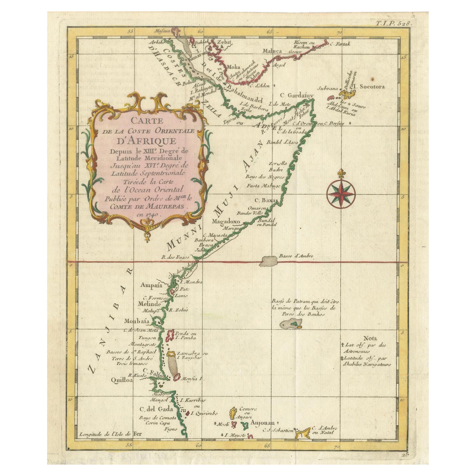
Mostra tuttoEast African Coast – French Map by Bellin, Zanzibar to Arabia, 1740
East African Coast – French Map by Bellin, Zanzibar to Arabia, 1740
This important French map depicts the eastern coast of Africa from Mozambique and Zanzibar northward to the Horn ...
Categoria
Di antiquariato/d’epoca, Anni 1740, Francese, Mappe
Materiali
Carta
Mappa antica dei dintorni di CAP-Français, Saint-Domingue, 1760 ca.
Mappa antica dei dintorni di CAP-Français, Saint-Domingue, 1760 ca.
Questa dettagliata incisione su rame del XVIII secolo, intitolata Carte des Environs du Cap Français et des Paroi...
Categoria
Di antiquariato/d’epoca, Inizio XVIII secolo, Francese, Mappe
Materiali
Carta
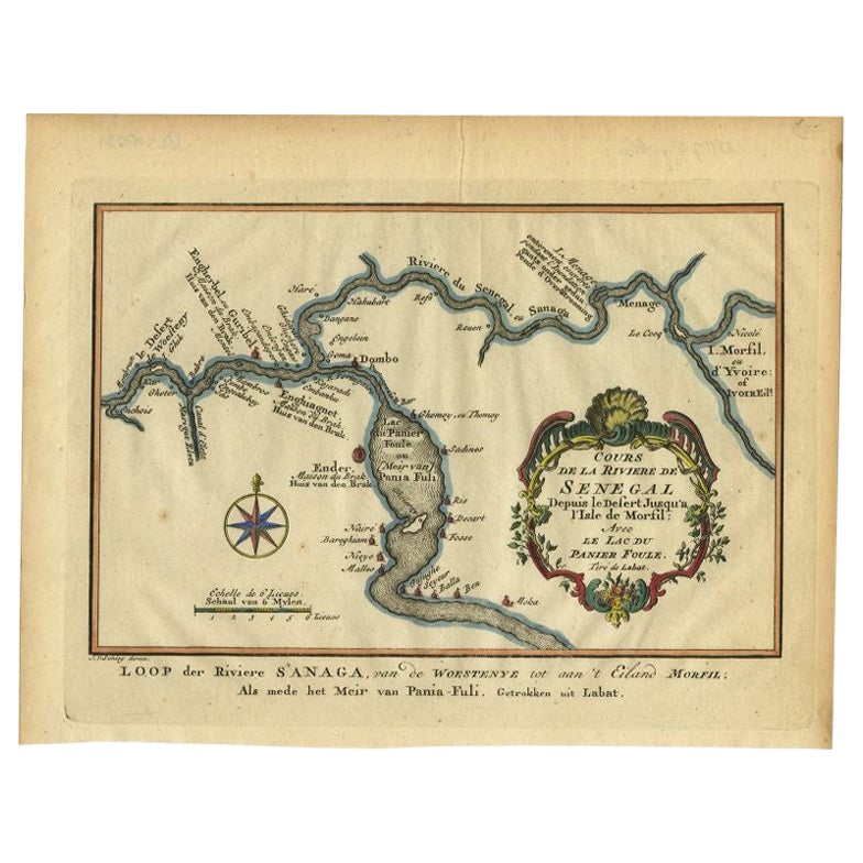
Carta antica del corso del fiume Sanaga di Van Schley, 1747
Carta geografica antica intitolata "Cours de la Riviere de Senegal (..) - Loop der Riviere Sanaga (..)". Mappa antica originale del corso del fiume Sanaga che forma il confine tra Se...
Categoria
Di antiquariato/d’epoca, XVIII secolo, Mappe
Materiali
Carta
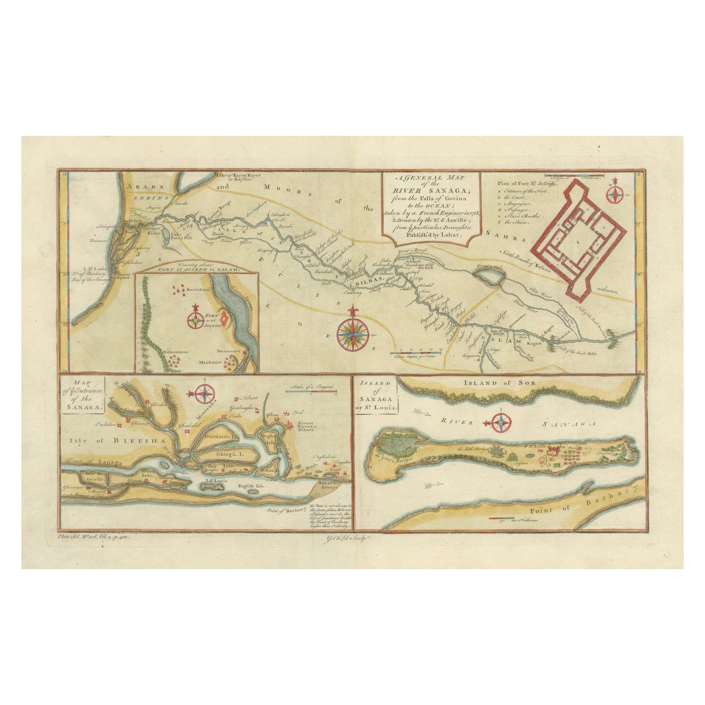
River Sanaga, West Africa – Elegant French Exploration Map, c.1750
Nubia and Abyssinia – Venetian Map of Northeast Africa, Zatta, 1784
This detailed late-18th-century map depicts Nubia and Abyssinia, covering large parts of present-day Sudan, Ethio...
Categoria
Di antiquariato/d’epoca, Anni 1750, Italiano, Mappe
Materiali
Carta
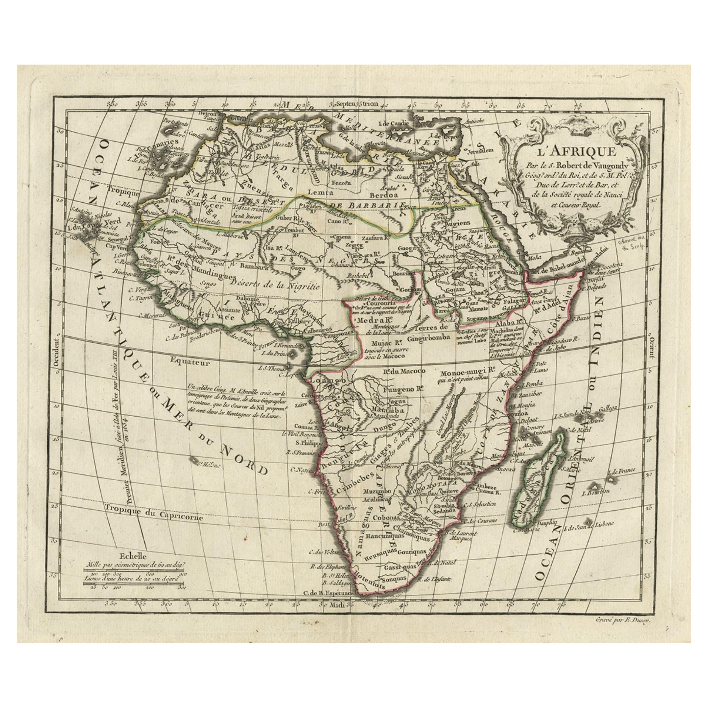
Carta geografica dell
Africa con cartiglio francese e scala, 1780 ca.
Carta geografica antica intitolata 'L'Afrique'. Mappa antica originale dell'Africa. Con bel cartiglio e scala del titolo. Fonte sconosciuta, da determinare.
Artisti e incisori: Gi...
Categoria
Di antiquariato/d’epoca, XVIII secolo, Mappe
Materiali
Carta
280 € Prezzo promozionale
20% in meno
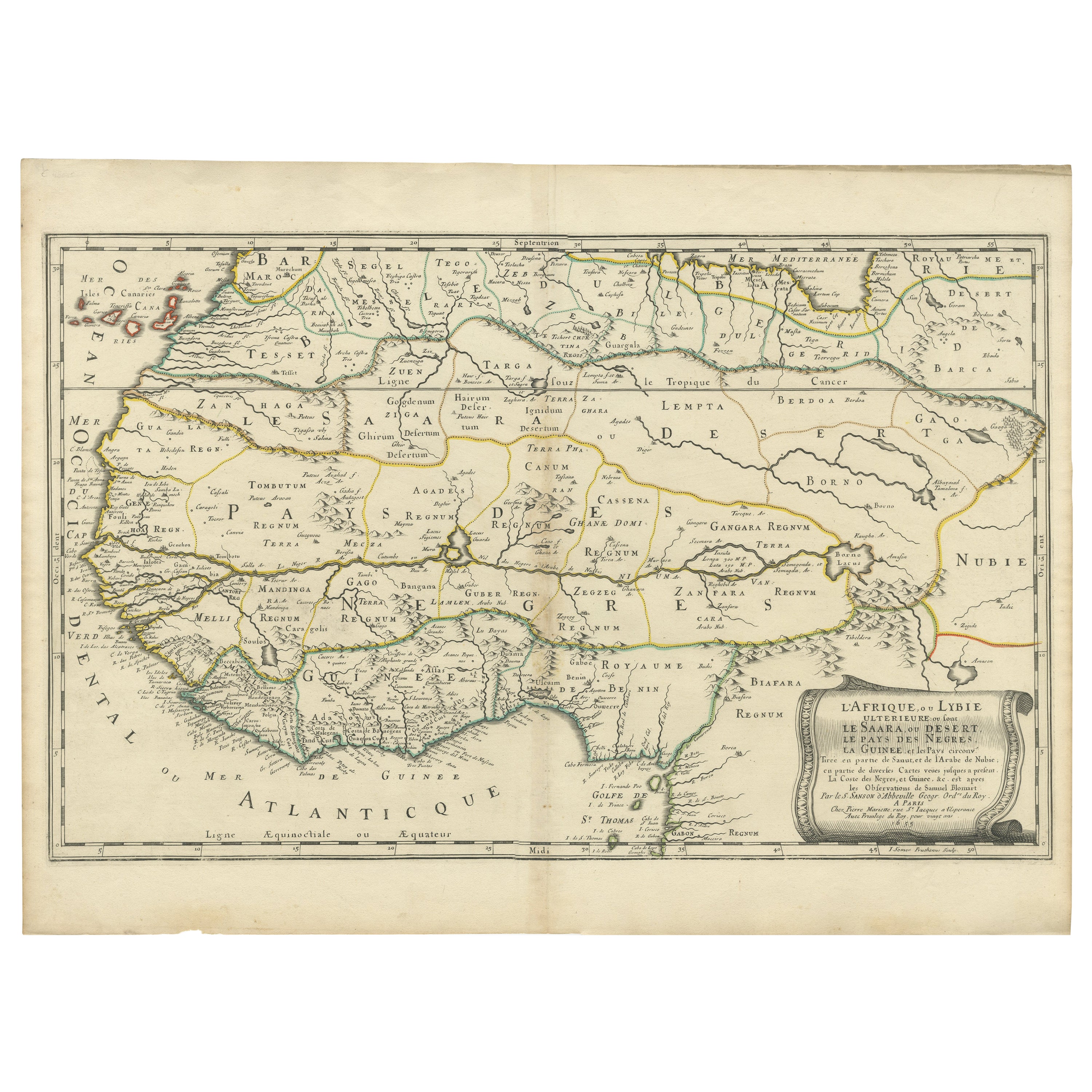
Attraente mappa antica dell
Africa occidentale con molti dettagli sulla costa, 1655
Titolo: "L'Afrique, ou Lybie ulterieure ou sont le Saara, ou Desert, le pays des negres, la Guinee, et les Pays circonv. Tirée en partie de Sanut, et de l'Arabe de Nubie; en partie d...
Categoria
Di antiquariato/d’epoca, Anni 1650, Mappe
Materiali
Carta
Ti potrebbe interessare anche
Africa occidentale intitolata "Guinea Propria": Una mappa di Homann colorata a mano del XVIII secolo
Di Johann Baptist Homann
Si tratta di una rara mappa dell'Africa incisa su lastra di rame riccamente colorata a mano intitolata "Guinea Propria, nec non Nigritiae vel Terrae Nigrorum Maxima Pars" di Johann B...
Categoria
Di antiquariato/d’epoca, Metà XVIII secolo, Tedesco, Mappe
Materiali
Carta

Africa occidentale intitolata "Guinea Propria": Una mappa di Homann colorata a mano del XVIII secolo
1304 € Prezzo promozionale
20% in meno
Africa Occidentale: Mappa di Homann del 18° secolo colorata a mano intitolata "Guinea Propria
Di Johann Baptist Homann
Si tratta di una rara mappa dell'Africa incisa su lastra di rame riccamente colorata a mano intitolata "Guinea Propria, nec non Nigritiae vel Terrae Nigrorum Maxima Pars" di Johann B...
Categoria
Anni 1740, Altro stile artistico, Stampe e riproduzioni
Materiali
Incisione

1304 € Prezzo promozionale
20% in meno
Antique French Map of Asia Including China Indoneseia India, 1783
Mappa dell'Asia molto bella. 1783 Dedie au Roy.
Informazioni aggiuntive:
Paese di produzione: Europa
Periodo: XVIII secolo Qing (1661 - 1912)
Condit: Condizioni generali B (buon usa...
Categoria
Di antiquariato/d’epoca, XVIII secolo, Europeo, Mappe
Materiali
Carta

422 € Prezzo promozionale
40% in meno
Africa: Una grande mappa colorata a mano del XVII secolo di Sanson e Jaillot
Di Nicholas Sanson d
Abbeville
Questa grande mappa originale dell'Africa incisa su rame e colorata a mano intitolata "L'Afrique divisee suivant l'estendue de ses principales parties ou sont distingues les uns des ...
Categoria
Anni 1690, Stampe (paesaggio)
Materiali
Incisione

1512 € Prezzo promozionale
20% in meno
Africa: Una grande mappa colorata a mano del XVII secolo di Sanson e Jaillot
Di Nicolas Sanson
Questa grande mappa originale dell'Africa incisa su rame e colorata a mano intitolata "L'Afrique divisee suivant l'estendue de ses principales parties ou sont distingues les uns des ...
Categoria
Di antiquariato/d’epoca, Anni 1690, Francese, Mappe
Materiali
Carta

1512 € Prezzo promozionale
20% in meno
"Africa Vetus": Una mappa colorata a mano del XVII secolo di Sanson
Di Nicholas Sanson d
Abbeville
Questa mappa originale dell'Africa incisa su rame e colorata a mano, intitolata "Africa Vetus, Nicolai Sanson Christianiss Galliar Regis Geographi", fu originariamente creata da Nich...
Categoria
Anni 1690, Stampe (paesaggio)
Materiali
Incisione

Nicholas Sanson d
Abbeville"Africa Vetus": Una mappa colorata a mano del XVII secolo di Sanson, 1696
956 € Prezzo promozionale
20% in meno