Articoli simili a Mozambique Bay – French Naval Sea Chart by Bellin, c.1765


Vuoi altre immagini o video?
Richiedi altre immagini o video al venditore
1 di 9
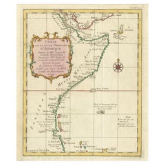
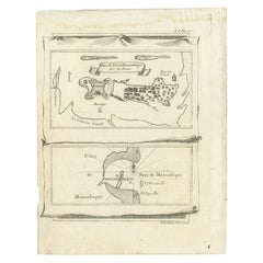
Mozambique Bay – French Naval Sea Chart by Bellin, c.1765
385 €IVA inclusa
Informazioni sull’articolo
Mozambique Bay – French Naval Sea Chart by Bellin, c.1765
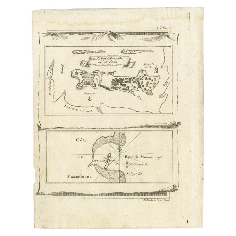
This detailed French sea chart depicts the Bay of Mozambique and the strategically vital island settlement of Mozambique, shown with its fortifications, anchorages, and surrounding islands. The map is titled “Carte de la Baye de Mosambique” and was engraved under the direction of Jacques-Nicolas Bellin, Hydrographer to the French King. It was published in Paris as part of Bellin’s hydrographic work for the Dépôt des cartes et plans de la Marine, circa 1760–1770.
Compiled from multiple manuscript sources, as stated directly in the cartouche (“Dressée sur divers Manuscrits”), the chart reflects the French navy’s effort to refine and correct earlier English and Portuguese mapping of the East African coast. Bellin explicitly notes that this chart differs significantly from English versions previously published, underscoring its role as an authoritative French alternative.
The map focuses on navigational precision. Soundings are carefully plotted throughout the bay, with shoals, reefs, and sandbanks clearly indicated. The fortified island of Mozambique is shown in detail, including the fort, town layout, batteries, and older fortifications. Surrounding islands such as St. George, St. Jacques, and Isle de Luchaque are identified, along with named channels and passes suitable for navigation.
A large compass rose dominates the lower right quadrant, reinforcing the chart’s maritime purpose. Coastal profiles, river mouths, and interior relief are rendered with clarity and restraint, typical of Bellin’s clean and highly legible engraving style. The overall composition balances technical accuracy with visual elegance.
This chart is an important document of 18th-century Indian Ocean navigation and colonial competition. Mozambique was a key hub linking East Africa with Arabia, India, and European trade networks, and Bellin’s charts of the region are increasingly sought after for both their historical relevance and decorative appeal.
Condition report
Good condition overall. Light, even age toning. Minor scattered spots and faint handling marks consistent with period. Plate mark visible. Full margins.
Framing tips
A light warm mat (ivory or pale sand) works well with the soft paper tone and monochrome engraving. A dark wood or black-stained frame enhances the strong graphic contrast of the coastline and compass rose, giving the map a refined, museum-style presentation. Ideal as a stand-alone piece or paired with Indian Ocean island charts.
Technique: Copper engraving
Maker: Jacques-Nicolas Bellin, France, c.1765
- Dimensioni:Altezza: 25,5 cm (10,04 in)Larghezza: 18,9 cm (7,45 in)Profondità: 0,2 mm (0,01 in)
- Materiali e tecniche:Carta,Inciso
- Luogo di origine:
- Periodo:
- Data di produzione:circa 1765
- Condizioni:Good condition overall. Light, even age toning. Minor scattered spots and faint handling marks consistent with period. Plate mark visible. Full margins.
- Località del venditore:Langweer, NL
- Numero di riferimento:Venditore: BG-14128-21stDibs: LU3054348016572
Informazioni sul venditore
5,0
Venditore riconosciuto
Questi venditori prestigiosi sono leader del settore e rappresentano il massimo in termini di qualità e design.
Venditore Platino
Venditori Premium con valutazione 4.7+ e tempi di risposta entro 24 ore
Fondazione nel 2009
Venditore 1stDibs dal 2017
2836 vendite su 1stDibs
Tempo di risposta standard: 1 ora
- SpedizioneRecupero del preventivo…Spedizione da: Langweer, Paesi Bassi
- Politica di reso
Alcune parti di questa pagina sono state tradotte automaticamente. 1stDibs non può garantire che le traduzioni siano corrette. L’inglese è la lingua predefinita del sito.
Altro da questo venditore
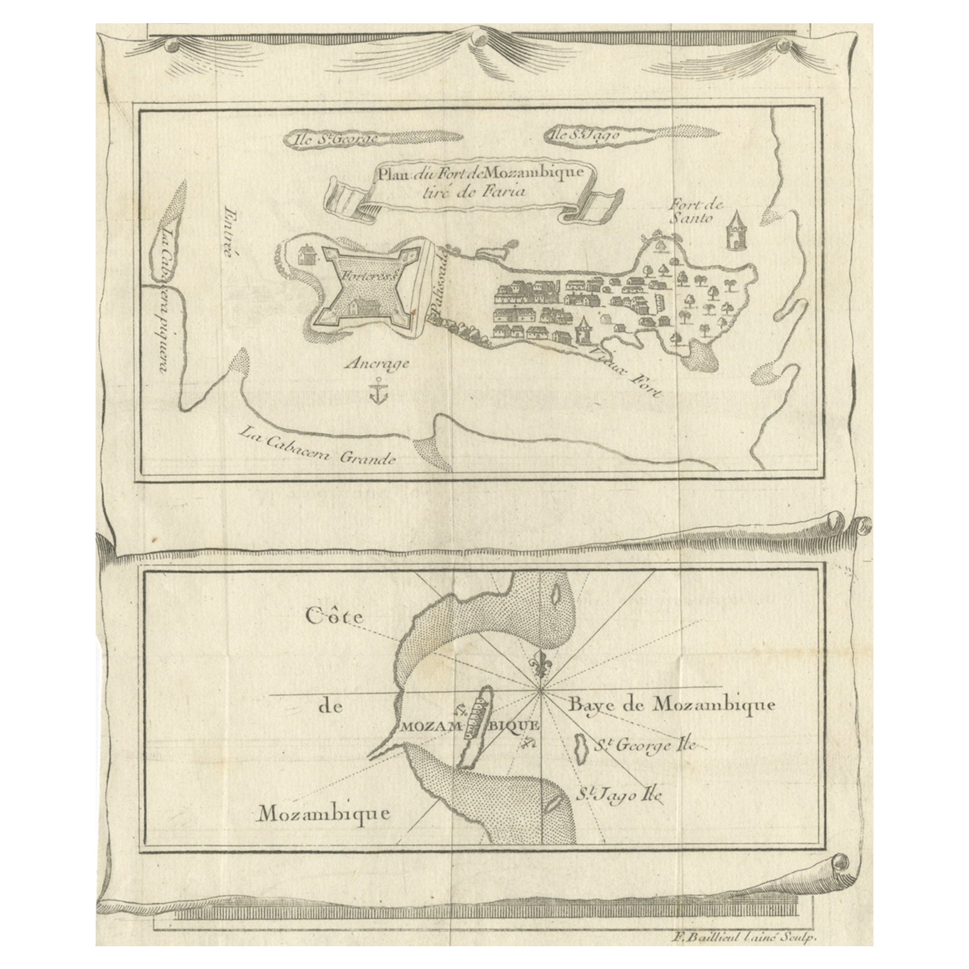
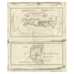
Mostra tuttoMappa antica di Fort Mozambique e della Baia di Mozambico in Africa, 1759 ca.
Due mappe antiche su un unico foglio. La mappa antica superiore è intitolata "Plan du Fort de Mozambique tiré de Faria" e raffigura l'isola di Mozambico con il suo forte, l'insediame...
Categoria
Di antiquariato/d’epoca, XVIII secolo, Mappe
Materiali
Carta
Canale di Mozambico e Madagascar - Carta del mare africano antica, Bonne c1780
Canale di Mozambico e Madagascar - Carta del mare africano antica, Bonne c1780
Descrizione:
Questa carta marittima finemente incisa della fine del XVIII secolo raffigura il Canale d...
Categoria
Di antiquariato/d’epoca, Fine XVIII secolo, Francese, Mappe
Materiali
Carta
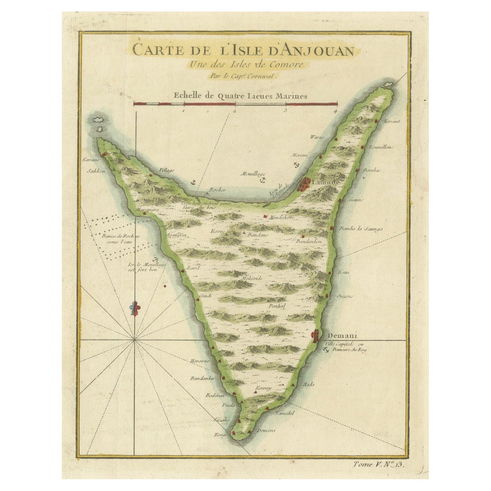
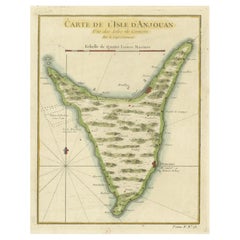
Anjouan Island, Comoros – French Naval Sea Chart by Bellin, c.1765
Anjouan Island, Comoros – French Naval Sea Chart by Bellin, c.1765
This finely engraved French sea chart depicts the island of Anjouan (Ndzuwani), one of the Comoros Islands in the ...
Categoria
Di antiquariato/d’epoca, Anni 1760, Francese, Mappe
Materiali
Carta
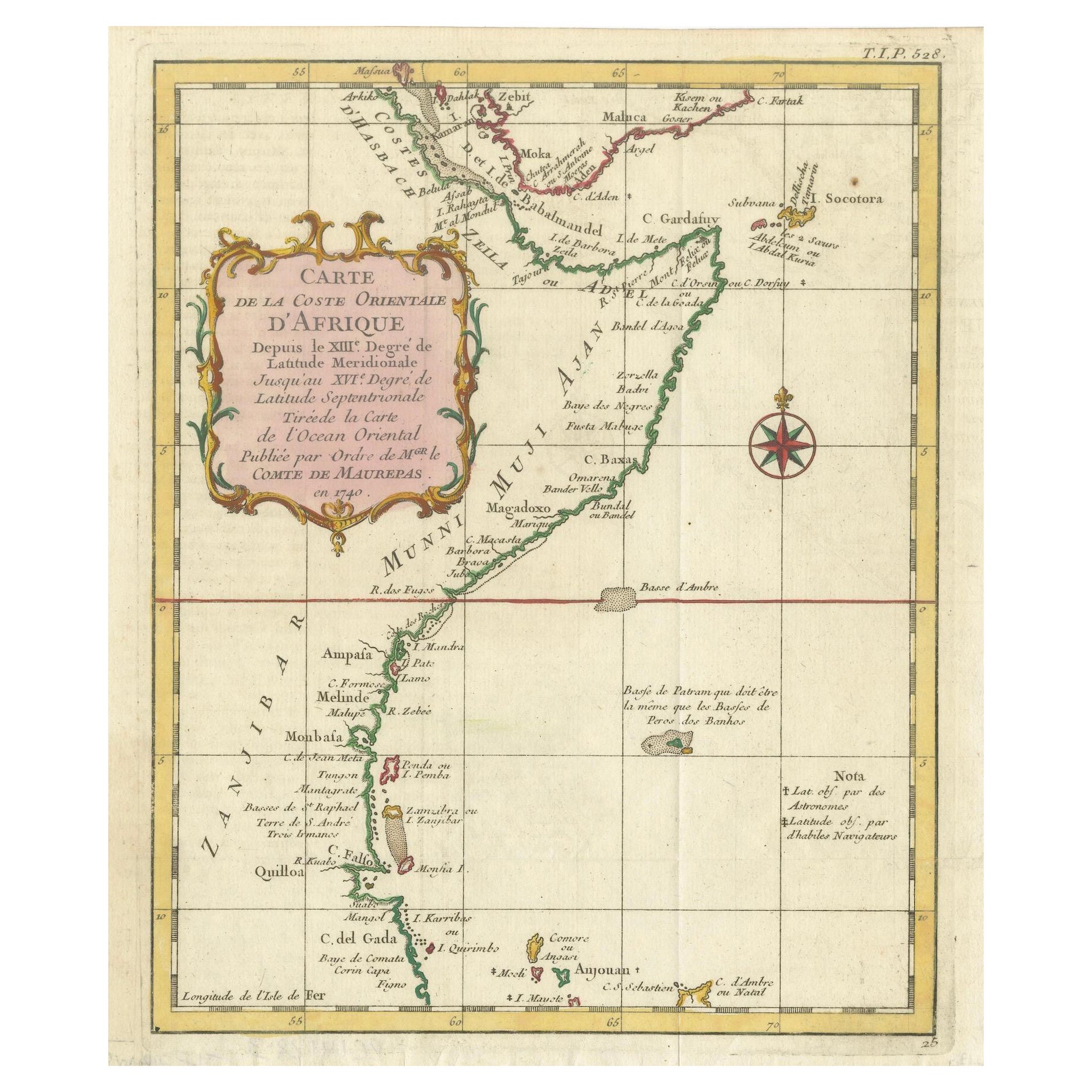
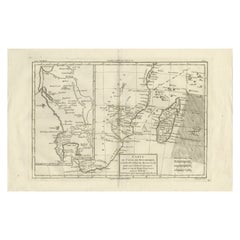
East African Coast – French Map by Bellin, Zanzibar to Arabia, 1740
East African Coast – French Map by Bellin, Zanzibar to Arabia, 1740
This important French map depicts the eastern coast of Africa from Mozambique and Zanzibar northward to the Horn ...
Categoria
Di antiquariato/d’epoca, Anni 1740, Francese, Mappe
Materiali
Carta
Mappa antica della baia di Mozambico e mappa di Fort de Mozambique, 1759 ca.
Due mappe antiche su un unico foglio. La mappa antica superiore è intitolata "Plan du Fort de Mozambique tiré de Faria" e raffigura l'isola di Mozambico con il suo forte, l'insediame...
Categoria
Di antiquariato/d’epoca, XVIII secolo, Mappe
Materiali
Carta
Mappa della Martinica di Rigobert Bonne - Mappa antica francese, 1768 ca.
Mappa della Martinica di Rigobert Bonne, 1768 circa
Questa è un'antica mappa dettagliata della Martinica intitolata "Isle de la Martinique", incisa da Rigobert Bonne intorno al 1768...
Categoria
Di antiquariato/d’epoca, Anni 1760, Francese, Mappe
Materiali
Carta

Ti potrebbe interessare anche
Costa occidentale dell
Africa; Guinea e Sierra Leone: Mappa di Bellin del 18° secolo
Si tratta di una mappa in rame di Jacques Bellin intitolata "Partie de la Coste de Guinee Dupuis la Riviere de Sierra Leona Jusquau Cap das Palmas", raffigurante la costa della Guine...
Categoria
Anni 1740, Antichi maestri, Stampe (paesaggio)
Materiali
Incisione

Costa occidentale dell
Africa, Guinea e Sierra Leone: Una mappa del XVIII secolo di Bellin
Di Jacques-Nicolas Bellin
La mappa in rame di Jacques Bellin intitolata "Partie de la Coste de Guinee Dupuis la Riviere de Sierra Leona Jusquau Cap das Palmas", che raffigura la costa della Guinea e della Sie...
Categoria
Di antiquariato/d’epoca, Metà XVIII secolo, Francese, Mappe
Materiali
Carta

Mappa dell
isola di Cuba - Guillaume Thomas Raynal (1711-1796)
Questa mappa storica dell'isola di Cuba è stata realizzata alla fine del XVIII secolo ed è tratta da un'edizione dell'"Atlas de toutes les parties connues du globe terrestre" dello s...
Categoria
Di antiquariato/d’epoca, XVIII secolo, Stampe
Materiali
Vetro, Carta

131 € Prezzo promozionale
50% in meno
Spedizione gratuita
Antica mappa pieghevole della Francia del 1765, Bordeau, ecc.
Strada delle Carosse de Bordeaux, part de Paris tous les Mardis a 11 matin. a et pafse 1765 è una mappa completa con due percorsi attraverso la Francia vinicola che parte da Parigi...
Categoria
Anni 1760, Altro stile artistico, Stampe (paesaggio)
Materiali
Acquaforte

Isola di Cadice: Una mappa incorniciata del XVII secolo colorata a mano dall
Atlante Maggiore di Blaeu
Di Joan (Johannes) Blaeu
Questa è una mappa colorata a mano del XVII secolo intitolata "Insula Gaditana Isla de Cadiz" tratta dall'Atlas Maior di Joan (Johannes) Blaeu, pubblicato ad Amsterdam nel 1662.
La ...
Categoria
Metà XVII secolo, Antichi maestri, Stampe (paesaggio)
Materiali
Incisione

Carta geografica antica - Mare Pacificum - Acquaforte di Johannes Janssonius - 1650
Di Johannes Janssonius
Il Mare Pacificum è un'antica mappa realizzata nel 1650 da Johannes Janssonius (1588-1664).
La mappa è un'acquaforte colorata a mano, con acquerello coevo.
Buone condizioni con leg...
Categoria
Anni 1650, Moderno, Stampe figurative
Materiali
Acquaforte
