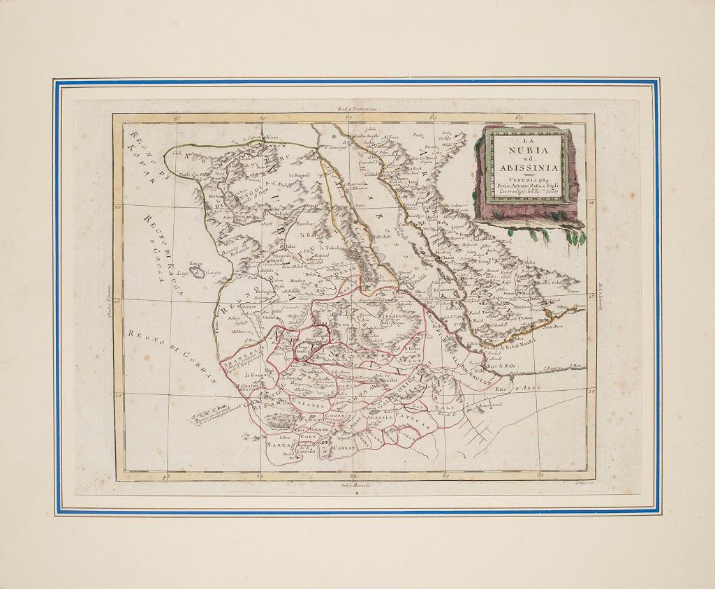
Articoli simili a Nubia and Abyssinia – Venetian Map of Northeast Africa, Zatta, 1784

Vuoi altre immagini o video?
Richiedi altre immagini o video al venditore
1 di 9
Nubia and Abyssinia – Venetian Map of Northeast Africa, Zatta, 1784
630 €IVA inclusa
Informazioni sull’articolo
Nubia and Abyssinia – Venetian Map of Northeast Africa, Zatta, 1784
This detailed late-18th-century map depicts Nubia and Abyssinia, covering large parts of present-day Sudan, Ethiopia, Eritrea, and the Horn of Africa. The map is titled “La Nubia ed Abissinia” and was published in Venice in 1784 by Antonio Zatta, one of the most important Italian map publishers of the period. It forms part of Zatta’s monumental Atlante Novissimo, produced with the privilege of the Venetian Senate.
The map presents the Nile basin in exceptional detail, tracing the river from its upper reaches through Nubia toward Egypt, while also mapping the Red Sea coast, inland mountain ranges, deserts, and regional kingdoms. Political and regional boundaries are outlined in contemporary hand color, distinguishing Nubia, Abyssinia, and neighboring territories. Numerous towns, tribal regions, rivers, and topographical features are carefully named, reflecting the synthesis of classical sources, Jesuit reports, and more recent travel accounts available to European geographers in the late Enlightenment period.
Zatta’s cartography represents the Italian continuation of the scientific mapping tradition pioneered by Delisle and d’Anville, emphasizing clarity, proportional accuracy, and critical compilation of sources. While interior Africa remained imperfectly known, this map shows a marked departure from earlier speculative geography, replacing legend with measured structure and comparative reasoning.
The decorative title cartouche, engraved in a restrained architectural style, anchors the upper right and reflects the sober elegance characteristic of Venetian Enlightenment cartography. Latitude and longitude lines, clean engraving, and balanced composition give the map strong visual presence without excess ornamentation.
This map is particularly appealing to collectors of African cartography, Nile exploration history, Ethiopian history, and Enlightenment-era geography. It also serves as an excellent intellectual counterpart to earlier French coastal and regional charts of Africa, illustrating the progression of European geographic knowledge during the 18th century.
Condition report
Good condition overall. Central vertical fold as issued. Light age toning and some mild discoloration, more noticeable along the fold. Minor scattered spots and faint handling marks. Original outline hand color. Plate mark visible. Margins intact.
Framing tips
A wide off-white or light sand-colored mat is recommended to balance the dense interior detail and preserve visual calm. A medium to dark wood frame enhances the engraved line work and complements the restrained hand coloring. Particularly effective as a scholarly centerpiece or paired with Indian Ocean or Nile-related maps.
Technique: Copper engraving with contemporary outline hand color
Maker: Antonio Zatta, Venice, 1784
Keywords: Nubia map, Abyssinia map, Ethiopia antique map, Northeast Africa cartography, Nile map, Blue Nile, White Nile, Red Sea map, Horn of Africa, Ethiopian Highlands, Kingdom of Nubia, Kingdom of Abyssinia, Gondar, Axum, Aksum, Sennar, Dongola, Suakin, Massawa, Zeila, Bab el Mandeb, Red Sea trade routes, Mecca, Mekka, Meca, Arabian Peninsula, African exploration map, 18th century map Africa, Venetian map, Antonio Zatta, Atlante Novissimo, Enlightenment cartography, antique engraved map
- Dimensioni:Altezza: 38,5 cm (15,16 in)Larghezza: 49,6 cm (19,53 in)Profondità: 0,2 mm (0,01 in)
- Materiali e tecniche:Carta,Inciso
- Luogo di origine:
- Periodo:1780-1789
- Data di produzione:circa 1784
- Condizioni:Good condition overall. Central vertical fold as issued. Light age toning and some mild discoloration, more noticeable along the fold. Minor scattered spots and faint handling marks. Original outline hand color. Plate mark visible. Margins intact.
- Località del venditore:Langweer, NL
- Numero di riferimento:Venditore: BG-14128-71stDibs: LU3054348016972
Informazioni sul venditore
5,0
Venditore riconosciuto
Questi venditori prestigiosi sono leader del settore e rappresentano il massimo in termini di qualità e design.
Venditore Platino
Venditori Premium con valutazione 4.7+ e tempi di risposta entro 24 ore
Fondazione nel 2009
Venditore 1stDibs dal 2017
2813 vendite su 1stDibs
Tempo di risposta standard: 1 ora
- SpedizioneRecupero del preventivo…Spedizione da: Langweer, Paesi Bassi
- Politica di reso
Alcune parti di questa pagina sono state tradotte automaticamente. 1stDibs non può garantire che le traduzioni siano corrette. L’inglese è la lingua predefinita del sito.
Altro da questo venditore
Mostra tuttoMappa antica originale dell
Abissinia, del Sudan e del Mar Rosso, 1749
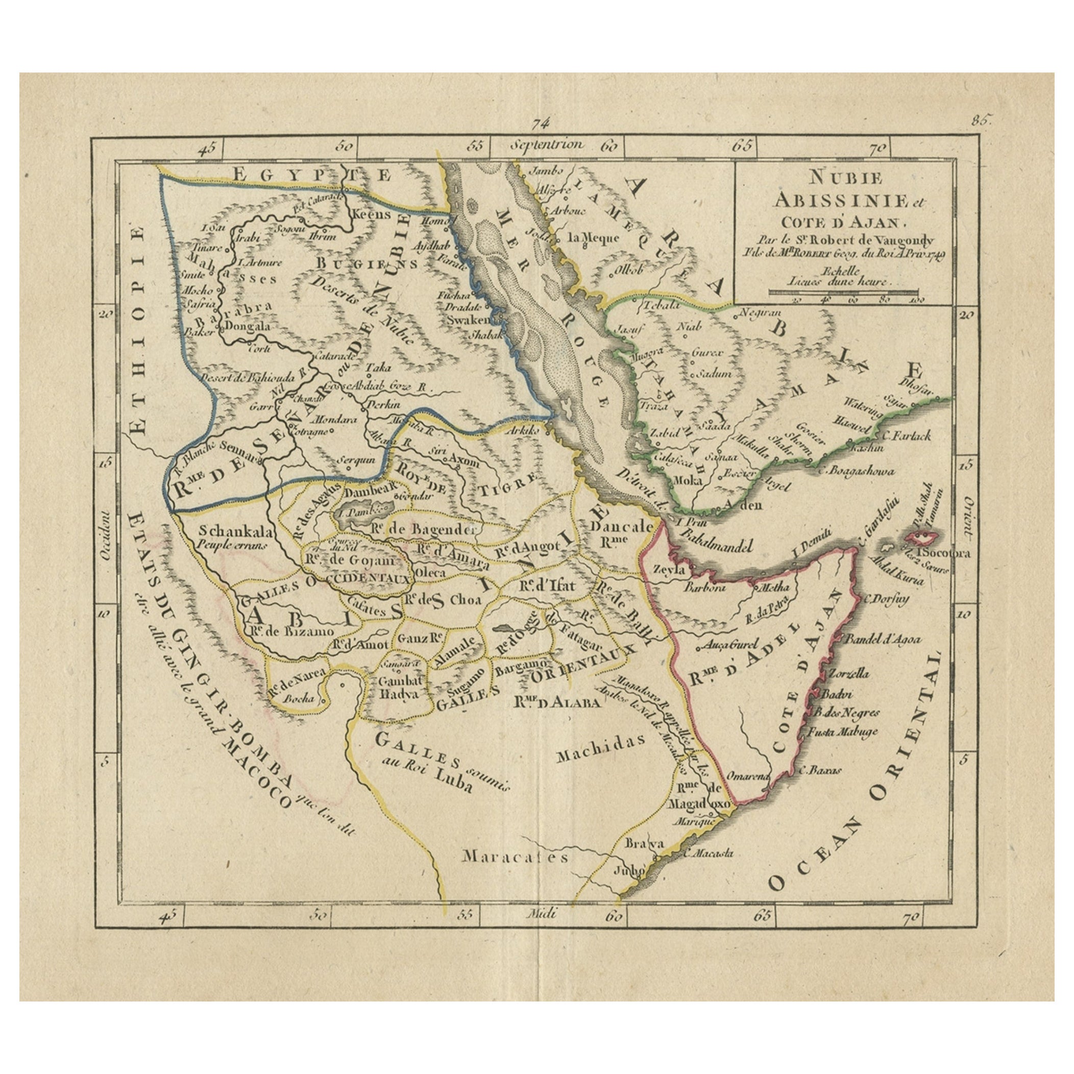
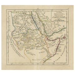
Carta geografica antica intitolata "Nubie, Abissinie et Cote d'Ajan".
Mappa dell'Abissinia, del Sudan e del Mar Rosso di Robert Vaugondy. Si estende dall'Arabia e dall'Egitto a sud...
Categoria
Di antiquariato/d’epoca, Anni 1740, Mappe
Materiali
Carta
272 € Prezzo promozionale
20% in meno
Carta geografica antica dell
Arabia che include la Nubia e l
Abissinia e mostra anche il Mar Rosso
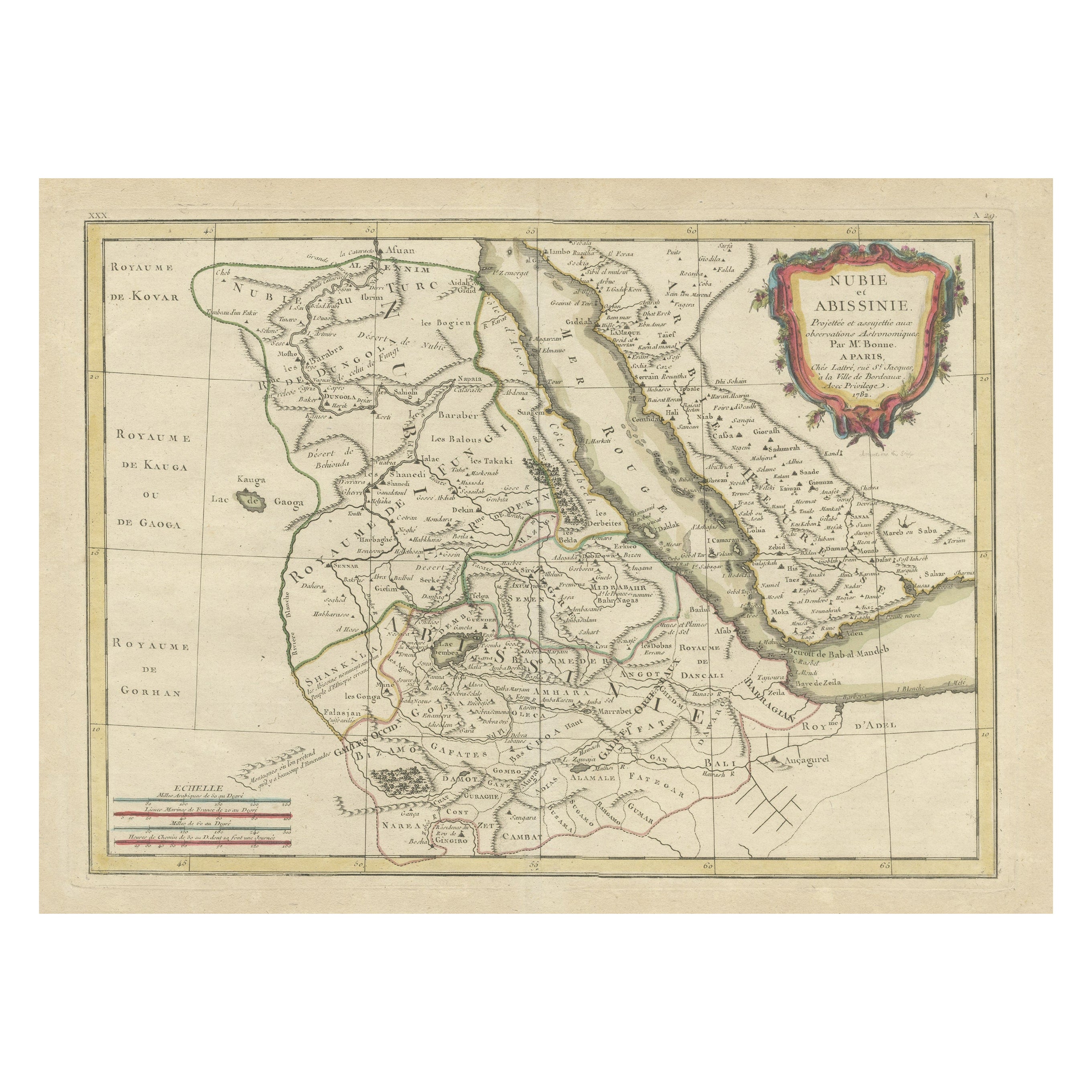
Carta geografica antica intitolata 'Nubie et Abissinie'. Mappa antica originale della Nubia, una regione lungo il fiume Nilo, e dell'Abissinia o Impero Etiopico. Questa mappa provien...
Categoria
Di antiquariato/d’epoca, Fine XVIII secolo, Mappe
Materiali
Carta

688 € Prezzo promozionale
20% in meno
Egypt
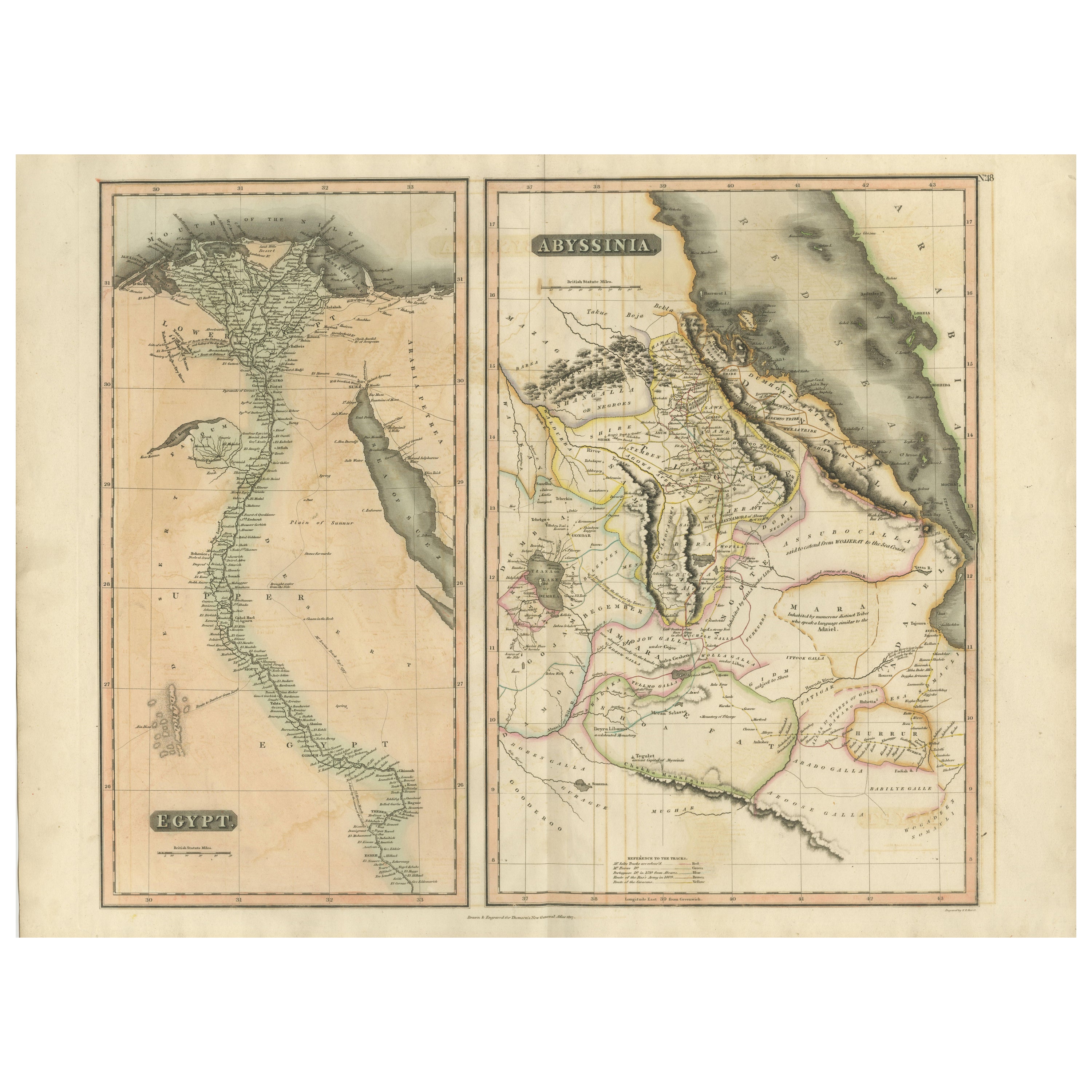
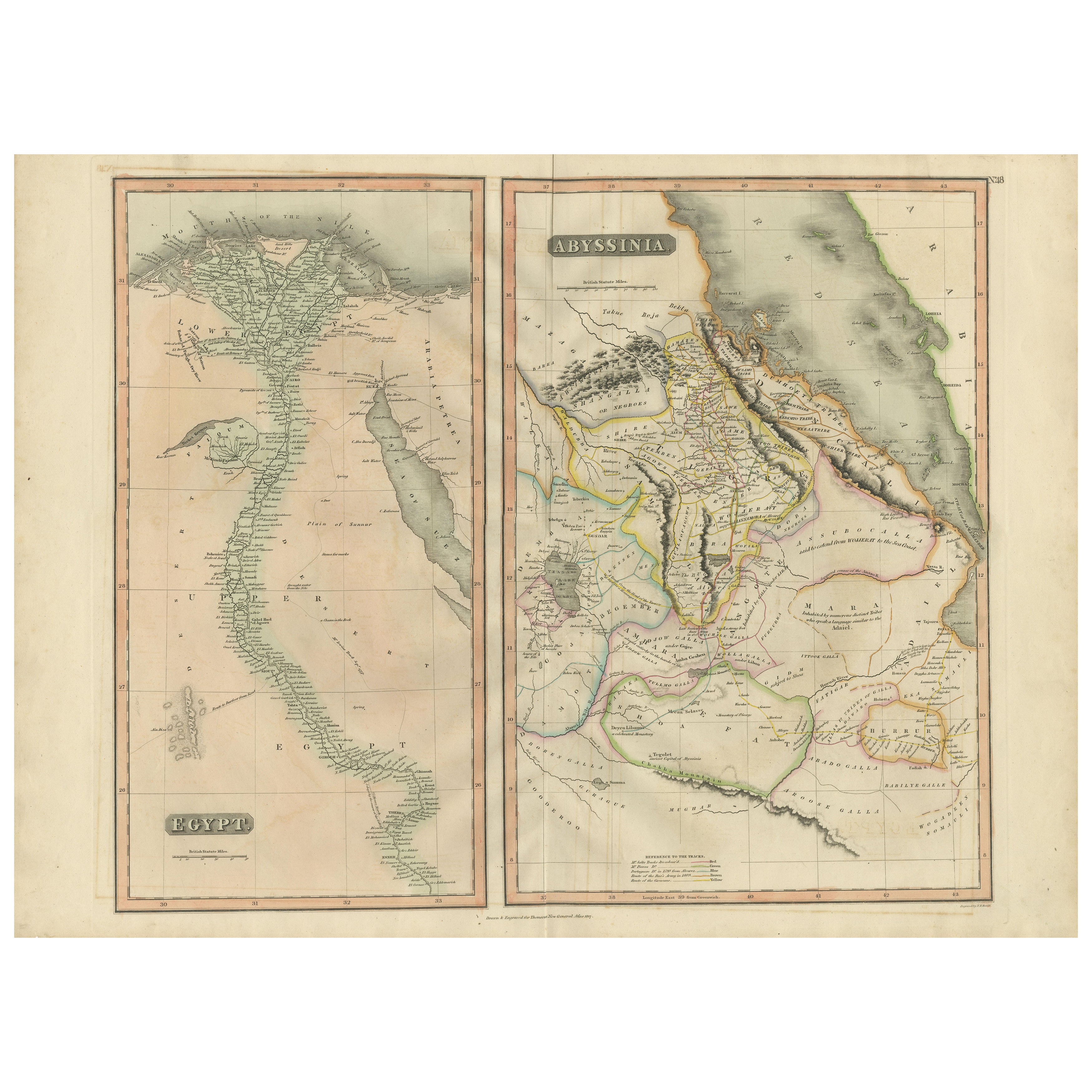
Abyssinia – Original Nile Valley and Horn of Africa Maps, c.1817
Egypt & Abyssinia – Nile Valley and Horn of Africa Maps, c.1817–1820
This refined early 19th-century map composition presents two related geographic views of Northeast Africa: Egypt...
Categoria
Di antiquariato/d’epoca, Anni 1810, Britannico, Mappe
Materiali
Carta
Egypt and Abyssinia – Nile Valley
Horn of Africa Maps, c.1817–1820
Egypt and Abyssinia – Nile Valley & Horn of Africa Maps, c.1817–1820
This refined early 19th-century paired map presents Egypt and Abyssinia (Ethiopia) as two complementary geograph...
Categoria
Di antiquariato/d’epoca, Anni 1810, Britannico, Mappe
Materiali
Carta
Mappa antica dell
Egitto con inserto dettagliato del Delta del Nilo, 1799 ca.
Mappa antica dell'Egitto con inserto dettagliato del Delta del Nilo, 1799 ca.
Questa mappa antica finemente incisa, intitolata Carte Physique et Politique de l'Égypte, presenta una ...
Categoria
Di antiquariato/d’epoca, Inizio Ottocento, Francese, Mappe
Materiali
Carta

Carta geografica antica del Nilo, dell
Egitto e del Mar Rosso di Bachiene, 1765
Carta geografica antica intitolata "De XIde Landkaart verbeeldende Egypte en de Woestyne der Schelf-Zee (...)". Mappa dell'Egitto biblico e del Mar Rosso. Con cartiglio del titolo, r...
Categoria
Di antiquariato/d’epoca, XVIII secolo, Mappe
Materiali
Carta

Ti potrebbe interessare anche
Mappa della Nubia e dell
Abissinia - Incisione originale di Antonio Zatta - 1784
Questa Mappa della Nubia e dell'Abissinia è un'incisione realizzata da Antonio Zatta a Venezia nel 1784.
Lo stato di conservazione dell'opera d'arte è buono, a parte la carta usurat...
Categoria
Anni 1770, Stampe (paesaggio)
Materiali
Acquaforte

"Africa Vetus": una mappa colorata a mano di Sanson del XVII secolo
Di Nicolas Sanson
Questa mappa originale dell'Africa incisa su rame e colorata a mano, intitolata "Africa Vetus, Nicolai Sanson Christianiss Galliar Regis Geographi", fu originariamente creata da Nich...
Categoria
Di antiquariato/d’epoca, Fine XVII secolo, Francese, Mappe
Materiali
Carta

952 € Prezzo promozionale
20% in meno
Africa occidentale intitolata "Guinea Propria": Una mappa di Homann colorata a mano del XVIII secolo
Di Johann Baptist Homann
Si tratta di una rara mappa dell'Africa incisa su lastra di rame riccamente colorata a mano intitolata "Guinea Propria, nec non Nigritiae vel Terrae Nigrorum Maxima Pars" di Johann B...
Categoria
Di antiquariato/d’epoca, Metà XVIII secolo, Tedesco, Mappe
Materiali
Carta

Africa occidentale intitolata "Guinea Propria": Una mappa di Homann colorata a mano del XVIII secolo
1299 € Prezzo promozionale
20% in meno
Mappa antica originale dell
Africa di Dower, 1835 circa
Bella mappa dell'Africa
Disegnato e inciso da J.Dower
Pubblicato da Orr & Smith. C.1835
Senza cornice.
Spedizione gratuita
Categoria
Di antiquariato/d’epoca, Anni 1830, Inglese, Mappe
Materiali
Carta

Africa: Una grande mappa colorata a mano del XVII secolo di Sanson e Jaillot
Di Nicolas Sanson
Questa grande mappa originale dell'Africa incisa su rame e colorata a mano intitolata "L'Afrique divisee suivant l'estendue de ses principales parties ou sont distingues les uns des ...
Categoria
Di antiquariato/d’epoca, Anni 1690, Francese, Mappe
Materiali
Carta

1507 € Prezzo promozionale
20% in meno
Costa occidentale dell
Africa, Guinea e Sierra Leone: Una mappa del XVIII secolo di Bellin
Di Jacques-Nicolas Bellin
La mappa in rame di Jacques Bellin intitolata "Partie de la Coste de Guinee Dupuis la Riviere de Sierra Leona Jusquau Cap das Palmas", che raffigura la costa della Guinea e della Sie...
Categoria
Di antiquariato/d’epoca, Metà XVIII secolo, Francese, Mappe
Materiali
Carta

398 € Prezzo promozionale
20% in meno