Articoli simili a River Sanaga, West Africa – Elegant French Exploration Map, c.1750


Vuoi altre immagini o video?
Richiedi altre immagini o video al venditore
1 di 9
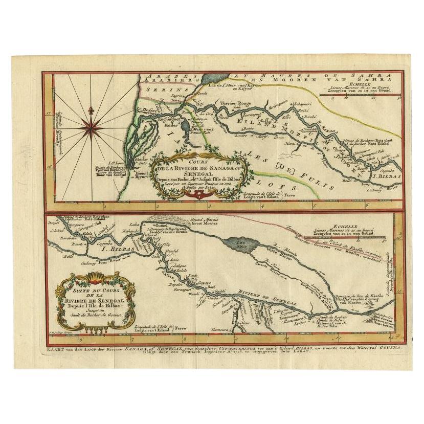
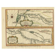
River Sanaga, West Africa – Elegant French Exploration Map, c.1750
630 €IVA inclusa
Informazioni sull’articolo
Nubia and Abyssinia – Venetian Map of Northeast Africa, Zatta, 1784
This detailed late-18th-century map depicts Nubia and Abyssinia, covering large parts of present-day Sudan, Ethiopia, Eritrea, and the Horn of Africa. The map is titled “La Nubia ed Abissinia” and was published in Venice in 1784 by Antonio Zatta, one of the most important Italian map publishers of the period. It forms part of Zatta’s monumental Atlante Novissimo, produced with the privilege of the Venetian Senate.
The map presents the Nile basin in exceptional detail, tracing the river from its upper reaches through Nubia toward Egypt, while also mapping the Red Sea coast, inland mountain ranges, deserts, and regional kingdoms. Political and regional boundaries are outlined in contemporary hand color, distinguishing Nubia, Abyssinia, and neighboring territories. Numerous towns, tribal regions, rivers, and topographical features are carefully named, reflecting the synthesis of classical sources, Jesuit reports, and more recent travel accounts available to European geographers in the late Enlightenment period.
Zatta’s cartography represents the Italian continuation of the scientific mapping tradition pioneered by Delisle and d’Anville, emphasizing clarity, proportional accuracy, and critical compilation of sources. While interior Africa remained imperfectly known, this map shows a marked departure from earlier speculative geography, replacing legend with measured structure and comparative reasoning.
The decorative title cartouche, engraved in a restrained architectural style, anchors the upper right and reflects the sober elegance characteristic of Venetian Enlightenment cartography. Latitude and longitude lines, clean engraving, and balanced composition give the map strong visual presence without excess ornamentation.
This map is particularly appealing to collectors of African cartography, Nile exploration history, Ethiopian history, and Enlightenment-era geography. It also serves as an excellent intellectual counterpart to earlier French coastal and regional charts of Africa, illustrating the progression of European geographic knowledge during the 18th century.
Condition report
Good condition overall. Central vertical fold as issued. Light age toning and some mild discoloration, more noticeable along the fold. Minor scattered spots and faint handling marks. Original outline hand color. Plate mark visible. Margins intact.
Framing tips
A wide off-white or light sand-colored mat is recommended to balance the dense interior detail and preserve visual calm. A medium to dark wood frame enhances the engraved line work and complements the restrained hand coloring. Particularly effective as a scholarly centerpiece or paired with Indian Ocean or Nile-related maps.
Technique: Copper engraving with contemporary outline hand color
Maker: Antonio Zatta, Venice, 1784
Keywords: Nubia map, Abyssinia map, Ethiopia antique map, Northeast Africa cartography, Nile map, Blue Nile, White Nile, Red Sea map, Horn of Africa, Ethiopian Highlands, Kingdom of Nubia, Kingdom of Abyssinia, Gondar, Axum, Aksum, Sennar, Dongola, Suakin, Massawa, Zeila, Bab el Mandeb, Red Sea trade routes, Mecca, Mekka, Meca, Arabian Peninsula, African exploration map, 18th century map Africa, Venetian map, Antonio Zatta, Atlante Novissimo, Enlightenment cartography, antique engraved map
- Dimensioni:Altezza: 34,7 cm (13,67 in)Larghezza: 43,7 cm (17,21 in)Profondità: 0,2 mm (0,01 in)
- Materiali e tecniche:Carta,Inciso
- Luogo di origine:
- Periodo:1750-1759
- Data di produzione:circa 1750
- Condizioni:Good condition overall. Central vertical fold as issued. Light age toning and some mild discoloration, more noticeable along the fold. Minor scattered spots and faint handling marks. Original outline hand color. Plate mark visible. Margins intact.
- Località del venditore:Langweer, NL
- Numero di riferimento:Venditore: BG-14128-61stDibs: LU3054348017042
Informazioni sul venditore
5,0
Venditore riconosciuto
Questi venditori prestigiosi sono leader del settore e rappresentano il massimo in termini di qualità e design.
Venditore Platino
Venditori Premium con valutazione 4.7+ e tempi di risposta entro 24 ore
Fondazione nel 2009
Venditore 1stDibs dal 2017
2821 vendite su 1stDibs
Tempo di risposta standard: 1 ora
- SpedizioneRecupero del preventivo…Spedizione da: Langweer, Paesi Bassi
- Politica di reso
Alcune parti di questa pagina sono state tradotte automaticamente. 1stDibs non può garantire che le traduzioni siano corrette. L’inglese è la lingua predefinita del sito.
Altro da questo venditore
Mostra tuttoMappa antica del fiume Sanaga, Senegal, 1747
Carta geografica antica intitolata "Cours De La Riviere De Sanaga Ou Senegal (..) - Kaart van den Loop der Riviere Sanaga (..)". Attraente mappa doppia del fiume Sanaga, Senegal, Afr...
Categoria
Di antiquariato/d’epoca, XVIII secolo, Mappe
Materiali
Carta
Mappa antica del fiume Gambia di J. Van Schley, 1750 circa
"Carte de la Riviere de Gambra ou Gambie. Depuis son Embouchure Jusqu a Eropina". Incisione in rame originale dopo il Cap. J. Mappa della regione di Leach del 1732. Con cartiglio orn...
Categoria
Di antiquariato/d’epoca, Metà XVIII secolo, Mappe
Materiali
Carta

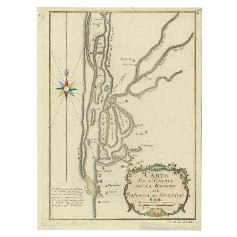
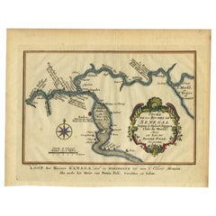
Mappa antica del fiume Senegal di Bellin, 1746
Carta geografica antica intitolata "Carte de l'Entrée de la Rivière de Sanaga ou Senegal". Mappa della foce del fiume Senegal. Questa mappa proviene dalla "Histoire Generale des Voya...
Categoria
Di antiquariato/d’epoca, XVIII secolo, Mappe
Materiali
Carta
188 € Prezzo promozionale
20% in meno
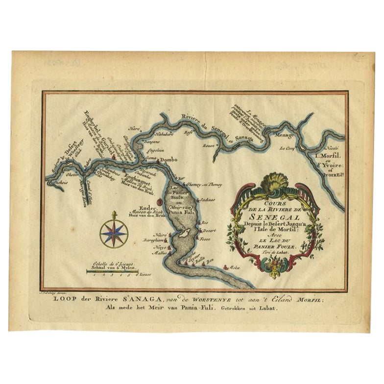
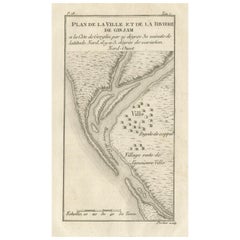
Carta antica del corso del fiume Sanaga di Van Schley, 1747
Carta geografica antica intitolata "Cours de la Riviere de Senegal (..) - Loop der Riviere Sanaga (..)". Mappa antica originale del corso del fiume Sanaga che forma il confine tra Se...
Categoria
Di antiquariato/d’epoca, XVIII secolo, Mappe
Materiali
Carta
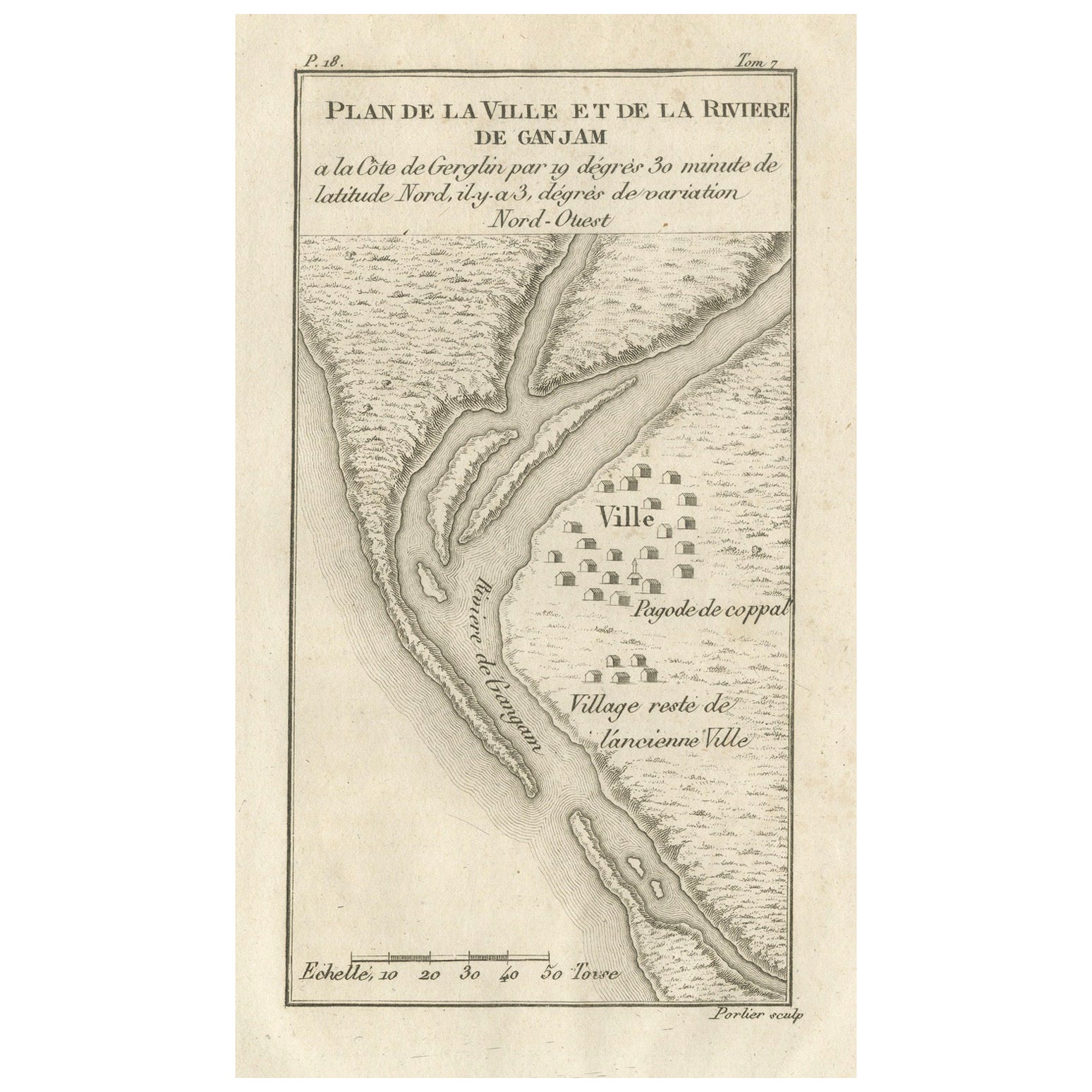
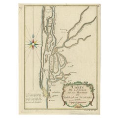
Pianta della città e del fiume di Ganjam, India - Antique French Map by Portier 1790
Pianta della città e del fiume di Ganjam, India - Carta francese antica di Portier, 1790 ca.
Questa antica incisione francese mostra una pianta dettagliata della città e del fiume d...
Categoria
Di antiquariato/d’epoca, Fine XVIII secolo, Francese, Mappe
Materiali
Carta
Carta antica del fiume e della baia di Tunquin, Siam, 1757
Carta geografica antica intitolata "Carte du Cours de la Riviere de Tunquin Depuis Cacho jusqu'à la Mer". Mappa dettagliata del fiume e della baia di Tunquin, che si estende a nord f...
Categoria
Di antiquariato/d’epoca, XVIII secolo, Francese, Mappe
Materiali
Carta

Ti potrebbe interessare anche
Costa occidentale dell
Africa, Guinea e Sierra Leone: Una mappa del XVIII secolo di Bellin
Di Jacques-Nicolas Bellin
La mappa in rame di Jacques Bellin intitolata "Partie de la Coste de Guinee Dupuis la Riviere de Sierra Leona Jusquau Cap das Palmas", che raffigura la costa della Guinea e della Sie...
Categoria
Di antiquariato/d’epoca, Metà XVIII secolo, Francese, Mappe
Materiali
Carta

399 € Prezzo promozionale
20% in meno
Africa occidentale intitolata "Guinea Propria": Una mappa di Homann colorata a mano del XVIII secolo
Di Johann Baptist Homann
Si tratta di una rara mappa dell'Africa incisa su lastra di rame riccamente colorata a mano intitolata "Guinea Propria, nec non Nigritiae vel Terrae Nigrorum Maxima Pars" di Johann B...
Categoria
Di antiquariato/d’epoca, Metà XVIII secolo, Tedesco, Mappe
Materiali
Carta

Africa occidentale intitolata "Guinea Propria": Una mappa di Homann colorata a mano del XVIII secolo
1301 € Prezzo promozionale
20% in meno
Costa occidentale dell
Africa; Guinea e Sierra Leone: Mappa di Bellin del 18° secolo
Si tratta di una mappa in rame di Jacques Bellin intitolata "Partie de la Coste de Guinee Dupuis la Riviere de Sierra Leona Jusquau Cap das Palmas", raffigurante la costa della Guine...
Categoria
Anni 1740, Antichi maestri, Stampe (paesaggio)
Materiali
Incisione

399 € Prezzo promozionale
20% in meno
Africa Occidentale: Mappa di Homann del 18° secolo colorata a mano intitolata "Guinea Propria
Di Johann Baptist Homann
Si tratta di una rara mappa dell'Africa incisa su lastra di rame riccamente colorata a mano intitolata "Guinea Propria, nec non Nigritiae vel Terrae Nigrorum Maxima Pars" di Johann B...
Categoria
Anni 1740, Altro stile artistico, Stampe e riproduzioni
Materiali
Incisione

1301 € Prezzo promozionale
20% in meno
1640 Carta di Joan Bleau intitolata "Diocecese de rheims et le pais de rethel, " Eic.a011
1640 Mappa di Joan Bleau intitolata
"Diocecese di Reims e il paese di Rethel".
Ric.a011
OAN BLAEU
Diocecese di Reims e il paese di Rethel.
Incisione colorata a mano, 1...
Categoria
Di antiquariato/d’epoca, XVII secolo, Olandese, Mappe
Materiali
Carta

Mappa Terra Santa La Terre Sainte Incisa van Loon Pubblicata N de Fer 1703 Francese
La Terre Sainte, La Terra Santa, Tiree Des Memoires De M.De.La Rue. Par N. de Fer. Geographe de Sa Majeste Catoliq et de Monseigneur le Dauphin. Avec Privil du Roi 1703
Mappa dett...
Categoria
Di antiquariato/d’epoca, Inizio Settecento, Francese, Luigi XIV, Mappe
Materiali
Carta
