Articoli simili a Geological Map of Europe by A.K. Johnston – Mountains and Valleys 1852


Vuoi altre immagini o video?
Richiedi altre immagini o video al venditore
1 di 10
Geological Map of Europe by A.K. Johnston – Mountains and Valleys 1852
260 €per articolo|IVA inclusa
Quantità
Informazioni sull’articolo
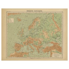
Geological Map of Europe by A.K. Johnston – Mountains and Valleys 1852
This elegant 1852 map titled "The Mountains, Table Lands, Plains
Valleys of Europe" was designed by the acclaimed Scottish geographer Alexander Keith Johnston and published by William Blackwood
Sons, Edinburgh and London. Issued as Plate 5 in Johnston’s pioneering work *The Physical Atlas of Natural Phenomena*, this map presents a physical topographic view of Europe with a focus on land elevation and terrain structure, rather than political borders.
Rendered in soft shades of beige, green, and blue, the map clearly delineates Europe’s major mountain ranges, including the Alps, Pyrenees, Carpathians, Apennines, and the Scandinavian Mountains. Valleys, upland plateaus, and lowlands are carefully shaded and labeled, giving a three-dimensional sense of the landscape. The careful use of hachuring and color gradients creates a tactile impression of Europe’s relief, from the Scottish Highlands to the Ural Mountains.
Rather than showing countries, the map categorizes the land by geological and geomorphological features. The title and key in the lower right explain the distinctions between highlands, tablelands, and low plains, emphasizing natural geography over human boundaries. This approach reflects the 19th-century scientific movement toward thematic cartography—maps made not to navigate or govern, but to understand physical phenomena.
Alexander Keith Johnston (1804–1871), Geographer in Ordinary to the Queen for Scotland, was one of the most respected mapmakers of the Victorian era. His *Physical Atlas* was a groundbreaking work in visual science, and among the first to systematically map climate, geology, hydrology, and landforms across the globe.
This plate is a beautifully executed example of early data visualization and remains highly relevant for collectors of antique scientific prints, students of European geography, or those seeking refined decorative maps for libraries, studies, or offices.
Condition and framing tips:
Very good antique condition with minor toning and slight edge wear. The print retains sharp detail and gentle original coloring. Best displayed in a black or walnut frame with a warm ivory or soft grey mat to highlight the topographic textures and historic typographic style. Ideal for natural history interiors or scholarly settings.
- Dimensioni:Altezza: 27,4 cm (10,79 in)Larghezza: 34,5 cm (13,59 in)Profondità: 0,2 mm (0,01 in)
- Materiali e tecniche:
- Luogo di origine:
- Periodo:
- Data di produzione:1852
- Condizioni:Very good condition. Light overall toning near the margins. The paper remains strong and well-preserved. Folding line as issued.
- Località del venditore:Langweer, NL
- Numero di riferimento:Venditore: BG-13207-51stDibs: LU3054345386522
Informazioni sul venditore
5,0
Venditore riconosciuto
Questi venditori prestigiosi sono leader del settore e rappresentano il massimo in termini di qualità e design.
Venditore Platino
Venditori Premium con valutazione 4.7+ e tempi di risposta entro 24 ore
Fondazione nel 2009
Venditore 1stDibs dal 2017
2810 vendite su 1stDibs
Tempo di risposta standard: <1 ora
- SpedizioneRecupero del preventivo…Spedizione da: Langweer, Paesi Bassi
- Politica di reso
Alcune parti di questa pagina sono state tradotte automaticamente. 1stDibs non può garantire che le traduzioni siano corrette. L’inglese è la lingua predefinita del sito.
Altro da questo venditore
Mostra tuttoMappa dell
Atlante in rilievo dell
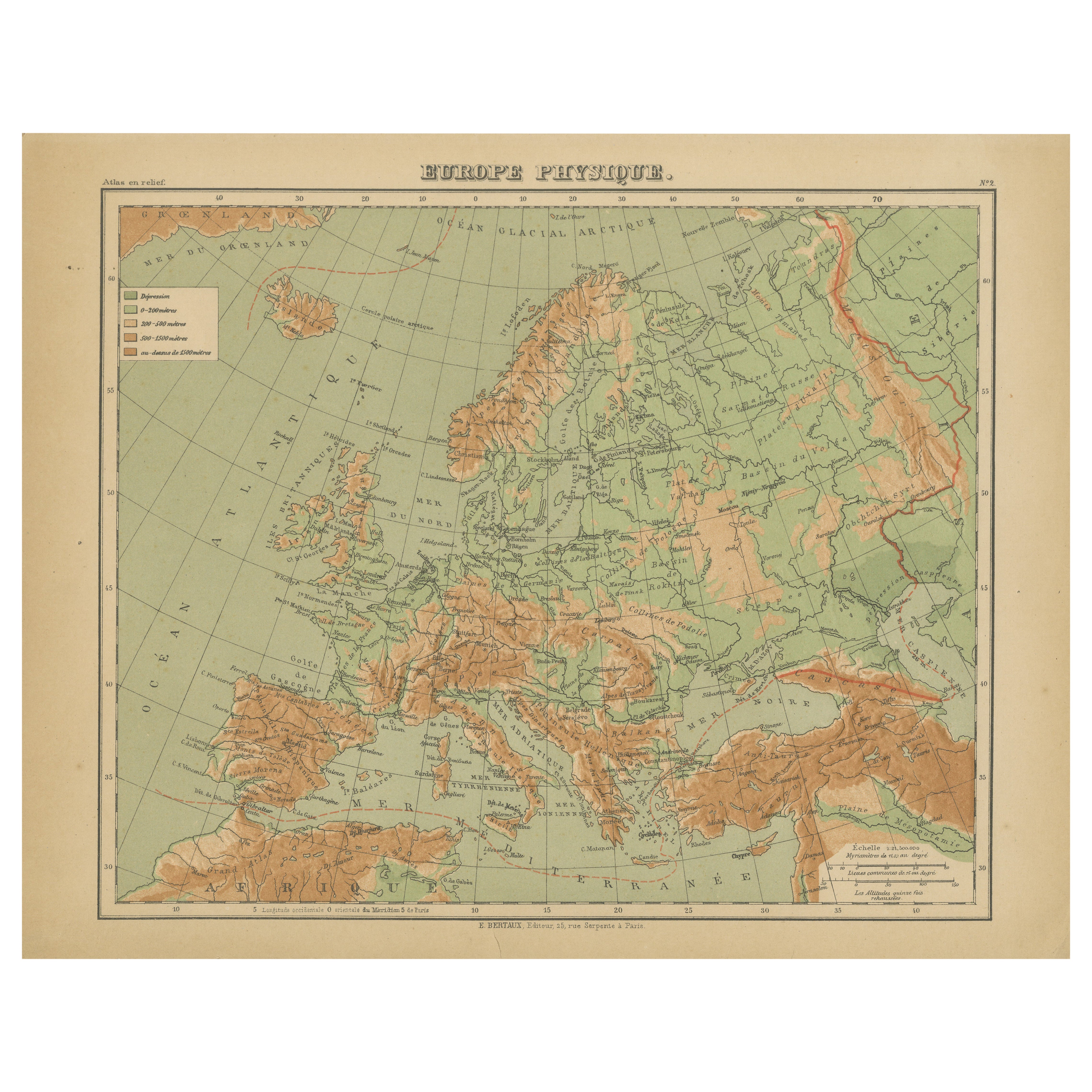
Europa di Hachette - Antique French Map c.1883
Carta geografica antica dell'Europa - Carta fisica in rilievo di Hachette, 1883 circa
Descrizione:
Questa mappa antica intitolata "Europe Physique" è stata pubblicata da Hachette a ...
Categoria
Di antiquariato/d’epoca, Fine XIX secolo, Francese, Mappe
Materiali
Carta
Mappa dell
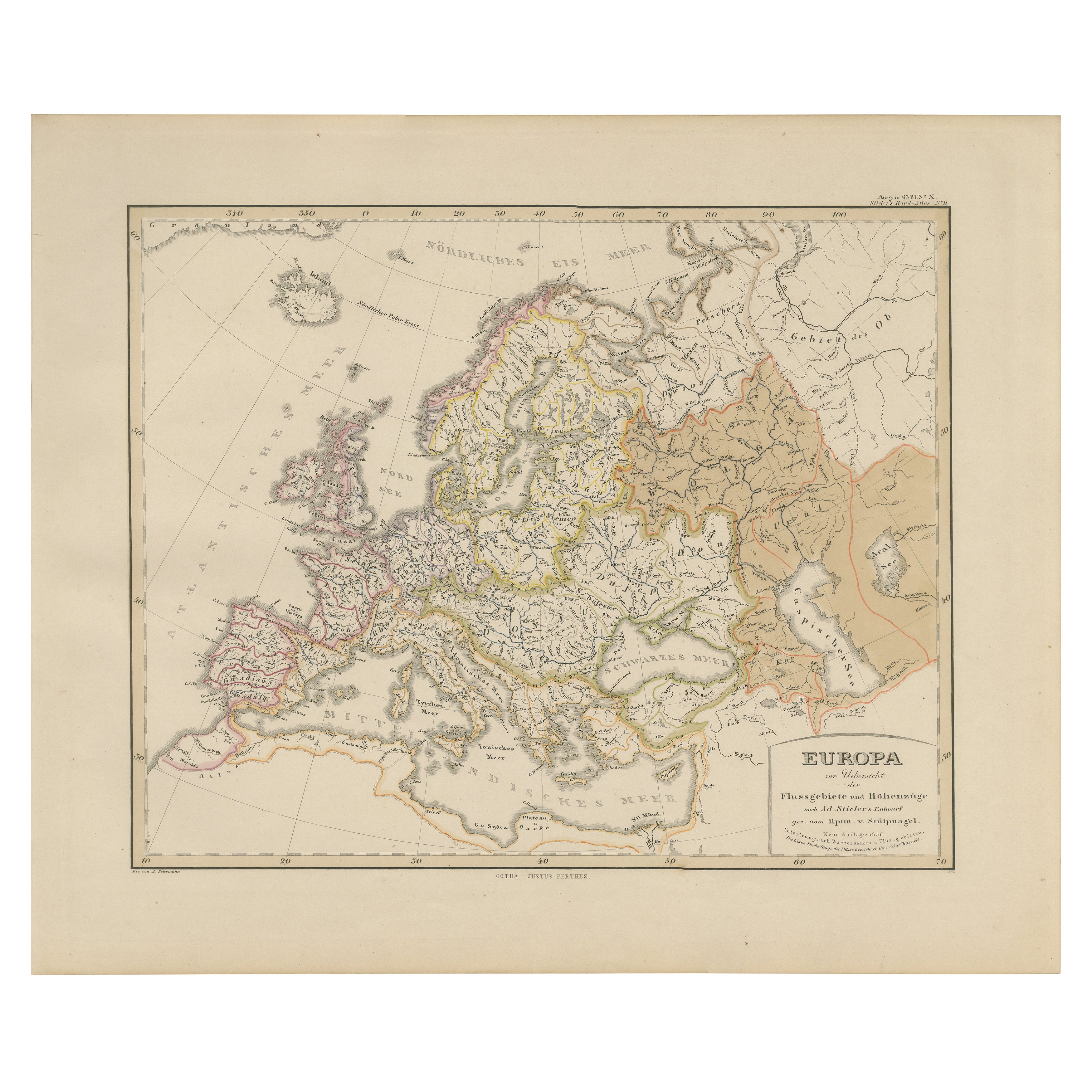
Europa - Fiumi, spartiacque ed elevazioni, pubblicata nel 1857
Mappa dell'Europa - Fiumi, spartiacque ed elevazione 1857
Questa bella stampa antica mostra l'Europa con i suoi sistemi fluviali e le sue regioni spartiacque, intitolata "Europa zur...
Categoria
Di antiquariato/d’epoca, Metà XIX secolo, Tedesco, Mappe
Materiali
Carta
Carta geografica antica dell
Europa, 1903, con confini politici intricati e ricchi dettagli
Titolo: Carta geografica antica dell'Europa, 1903, con confini politici intricati e ricchi dettagli
Descrizione:
Questa mappa antica, intitolata "Europa", è un capolavoro cartografi...
Categoria
Inizio XX secolo, Mappe
Materiali
Carta

Carta geografica antica dell
Europa di W. G. Blackie, 1859
Carta geografica antica intitolata "Europa". Mappa antica originale dell'Europa. Questa mappa proviene da "The Imperial Atlas of Modern Geography". Pubblicato da W. G. Blackie, 1859.
Categoria
Di antiquariato/d’epoca, Metà XIX secolo, Mappe
Materiali
Carta

200 € Prezzo promozionale
20% in meno
Mappa dell
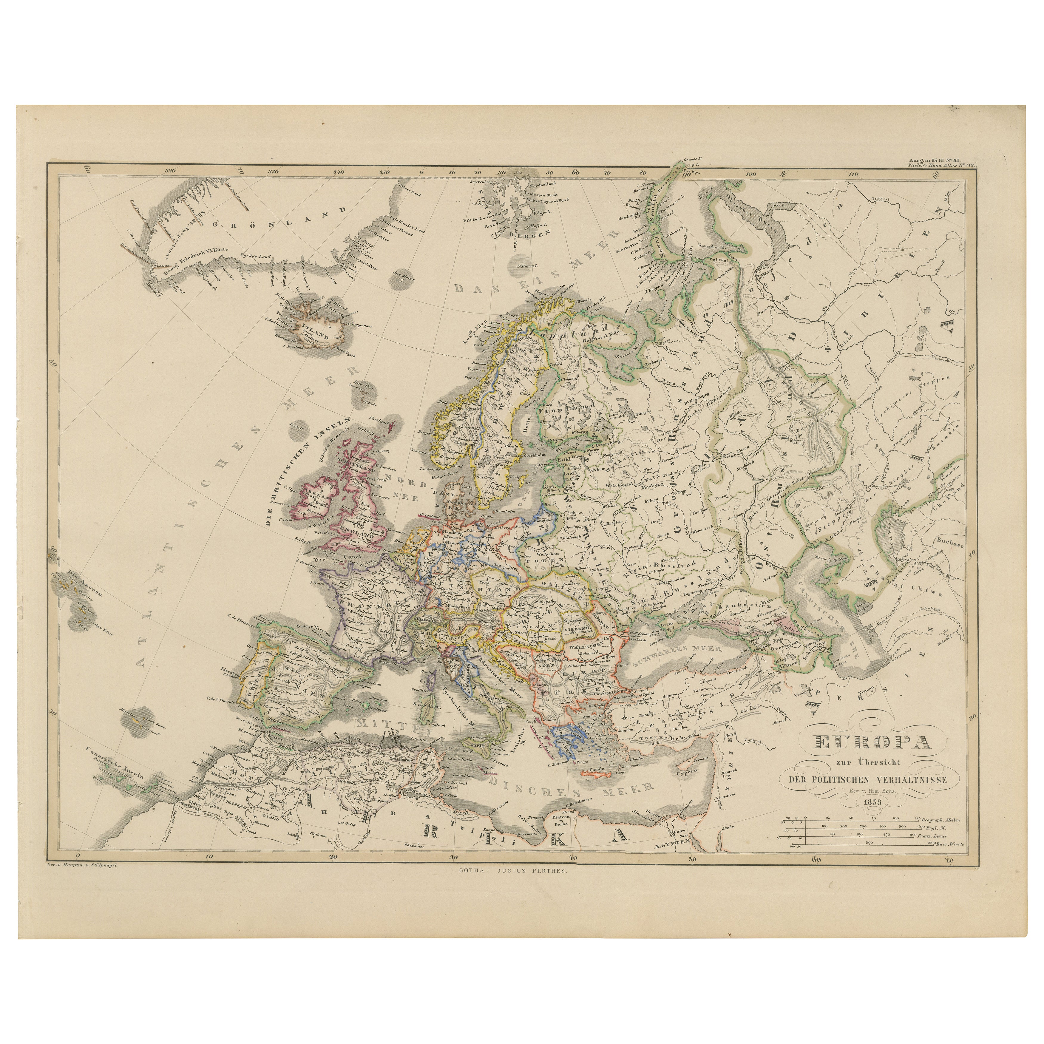
Europa - Divisioni politiche e confini, pubblicata nel 1858
Mappa dell'Europa - Divisioni politiche e confini 1858
Questa bella stampa antica mostra l'Europa con le sue divisioni politiche, intitolata "Europa zur Übersicht der politischen Ve...
Categoria
Di antiquariato/d’epoca, Metà XIX secolo, Tedesco, Mappe
Materiali
Carta
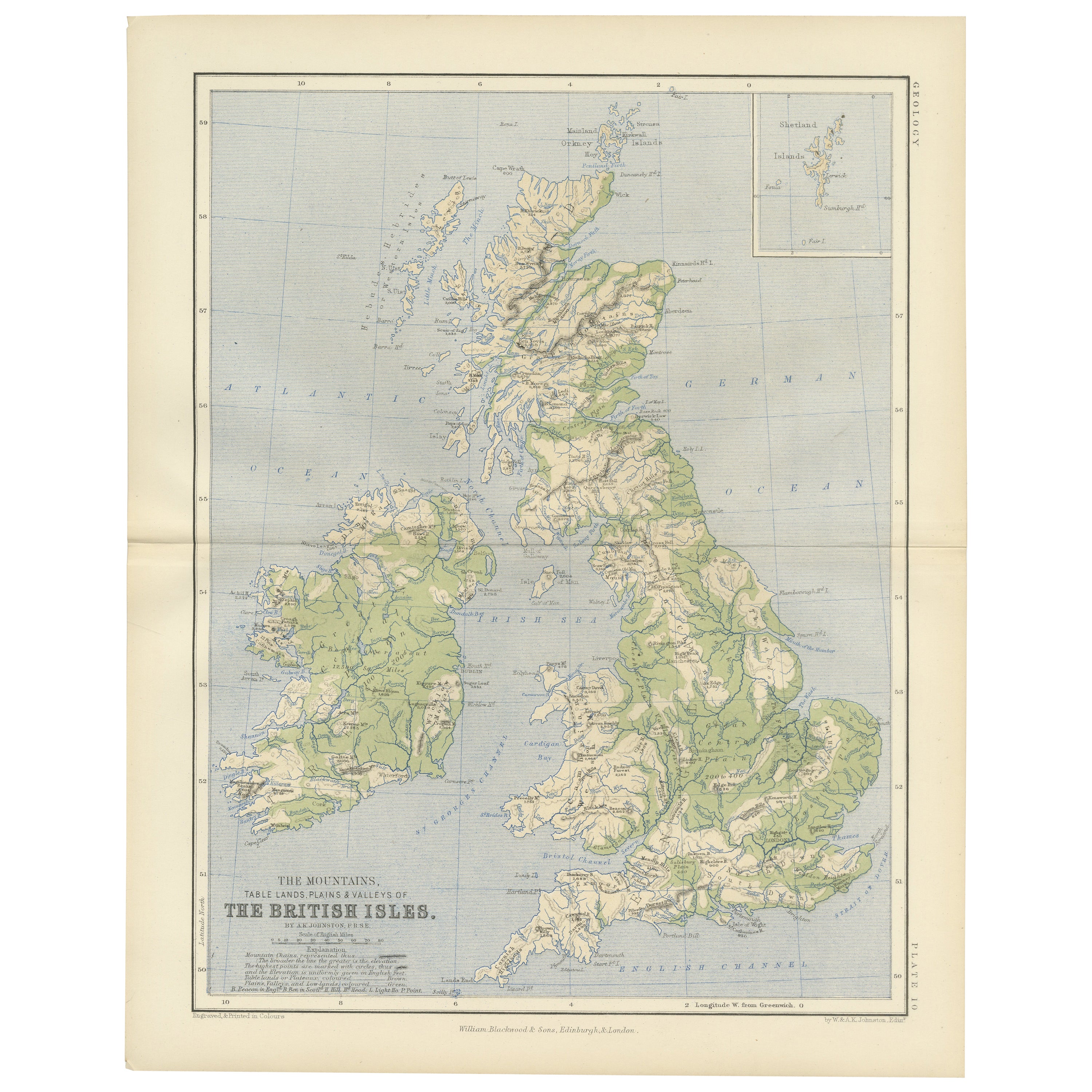
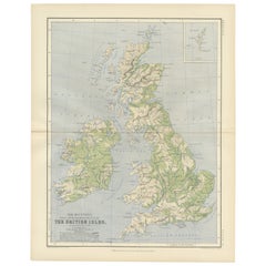
Geological Map of the British Isles by A.K. Johnston – Highlands
Valleys 1852
Geological Map of the British Isles by A.K. Johnston – Highlands & Valleys 1852
This antique topographic map titled "The Mountains, Table Lands, Plains & Valleys of the British Isle...
Categoria
Di antiquariato/d’epoca, Metà XIX secolo, Scozzese, Stampe
Materiali
Carta
Ti potrebbe interessare anche
Mappa dell
Europa, 1844
Mappa dell'Europa incisa da Olney nel 1844, risalente a oltre 150 anni fa. Colore originale a mano. Mostra l'Europa del Nord, la Prussia e la Germania.
Mappa antica originale su...
Categoria
Anni 1840, Altre stampe
Materiali
Inchiostro, Acquarello, Carta fatta a mano

Grande mappa antica originale dell
Europa di Sidney Hall, 1847
Grande mappa dell'Europa
Disegnato e inciso da Sidney Hall
Incisione in acciaio
Schema originale a colori
Pubblicato da A & C Black. 1847
Non incorniciato
Spedizio...
Categoria
Di antiquariato/d’epoca, Anni 1840, Scozzese, Mappe
Materiali
Carta

Mappa antica originale dell
Europa, Arrowsmith, 1820
Grande mappa dell'Europa
Disegnato sotto la direzione di Arrowsmith.
Incisione su rame.
Pubblicato da Longman, Hurst, Rees, Orme, & Brown, 1820
Senza cornice.
Categoria
Di antiquariato/d’epoca, Anni 1820, Inglese, Mappe
Materiali
Carta

Mappa dell
Europa colorata a mano in due parti del 1798
Di Thomas Kitchin
Mappa dell'Europa stampata su due fogli separati da A New Universal Atlas di Thomas Kitchin. Pubblicato a Londra da Laurie & Whittle, 1798. Incisioni originali colorate a mano al mom...
Categoria
Anni 1790, Altra arte
Materiali
Carta

1479 € Prezzo promozionale
33% in meno
Mappa di Thomas Stackhouse del 1790, intitolata "Russia in Europa", Ric.a004
Mappa di Thomas Stackhouse del 1790, intitolata
"Russia in Europa
Ric.a004
Stackhouse, Thomas
La Russia in Europa [mappa]
Londra: T. Stackhouse, 1783. Mappa. Incisione in ra...
Categoria
Di antiquariato/d’epoca, XVII secolo, Sconosciuto, Mappe
Materiali
Carta

Francia, Part One. Mappa antica Century Atlas
L'Atlante del Secolo. Francia, parte settentrionale".
Mappa antica originale, 1903.
Cartine di "Francia in Province" e "Parigi e dintorni".
Piega centrale come da edizione. Nome e ...
Categoria
Inizio XX secolo, Vittoriano, Altre stampe
Materiali
Litografia
