Articoli simili a Geological Map of the British Isles by A.K. Johnston – Highlands
Valleys 1852


Vuoi altre immagini o video?
Richiedi altre immagini o video al venditore
1 di 10
Geological Map of the British Isles by A.K. Johnston – Highlands
Valleys 1852
260 €per articolo|IVA inclusa
Quantità
Informazioni sull’articolo
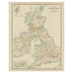
Geological Map of the British Isles by A.K. Johnston – Highlands
Valleys 1852
This antique topographic map titled "The Mountains, Table Lands, Plains
Valleys of the British Isles" was created by Alexander Keith Johnston and published in 1852 by William Blackwood
Sons in Edinburgh and London. It forms Plate 10 in Johnston’s landmark *Physical Atlas of Natural Phenomena*, one of the most influential works of thematic cartography of the 19th century.
The map offers a clear and scientific representation of the physical geography of Great Britain and Ireland, highlighting major mountain ranges, highlands, plains, river valleys, and tablelands using fine engraved detail and hand-applied color washes. Rather than depicting political boundaries, this plate focuses entirely on natural landforms and their elevations, providing insight into the geological character of the region.
Key physical features include the Highlands and Grampians of Scotland, the Pennines in northern England, the Cambrian Mountains of Wales, and the Cumbrian Fells. Ireland is shown with its central lowlands ringed by uplands, and an inset in the upper right corner details the Shetland Islands. Rivers such as the Thames, Shannon, Severn, and Clyde are precisely mapped, and lowland basins like those surrounding the Wash and the Fens are delicately shaded in green.
This map reflects the mid-19th century shift from political and colonial maps to scientific and thematic cartography. Alexander Keith Johnston (1804–1871), Geographer in Ordinary to Queen Victoria in Scotland, was one of the leading cartographic figures of his time. His *Physical Atlas* was the first to systematically visualize natural phenomena on a global scale through beautifully engraved and colored maps. This map is part of that series and stands as a testament to the combination of precision, clarity, and aesthetic quality in Victorian scientific publishing.
Highly collectible and still relevant today, this plate is perfect for historians, educators, or anyone with an interest in British natural history and geography.
Condition and framing tips:
Very good antique condition with minor age toning and a clean printed surface. Original centerfold as issued.
Ideal for framing in walnut, oak, or black wood with a warm ivory or cool grey mat to complement the greens and earth tones. A beautiful addition to a study, library, or historically inspired interior.
- Dimensioni:Altezza: 34,5 cm (13,59 in)Larghezza: 27,4 cm (10,79 in)Profondità: 0,2 mm (0,01 in)
- Materiali e tecniche:
- Luogo di origine:
- Periodo:
- Data di produzione:1852
- Condizioni:Very good condition. Light overall toning near the margins. The paper remains strong and well-preserved. Folding line as issued.
- Località del venditore:Langweer, NL
- Numero di riferimento:Venditore: BG-13207-101stDibs: LU3054345388152
Informazioni sul venditore
5,0
Venditore riconosciuto
Questi venditori prestigiosi sono leader del settore e rappresentano il massimo in termini di qualità e design.
Venditore Platino
Venditori Premium con valutazione 4.7+ e tempi di risposta entro 24 ore
Fondazione nel 2009
Venditore 1stDibs dal 2017
2809 vendite su 1stDibs
Tempo di risposta standard: 1 ora
- SpedizioneRecupero del preventivo…Spedizione da: Langweer, Paesi Bassi
- Politica di reso
Alcune parti di questa pagina sono state tradotte automaticamente. 1stDibs non può garantire che le traduzioni siano corrette. L’inglese è la lingua predefinita del sito.
Altro da questo venditore
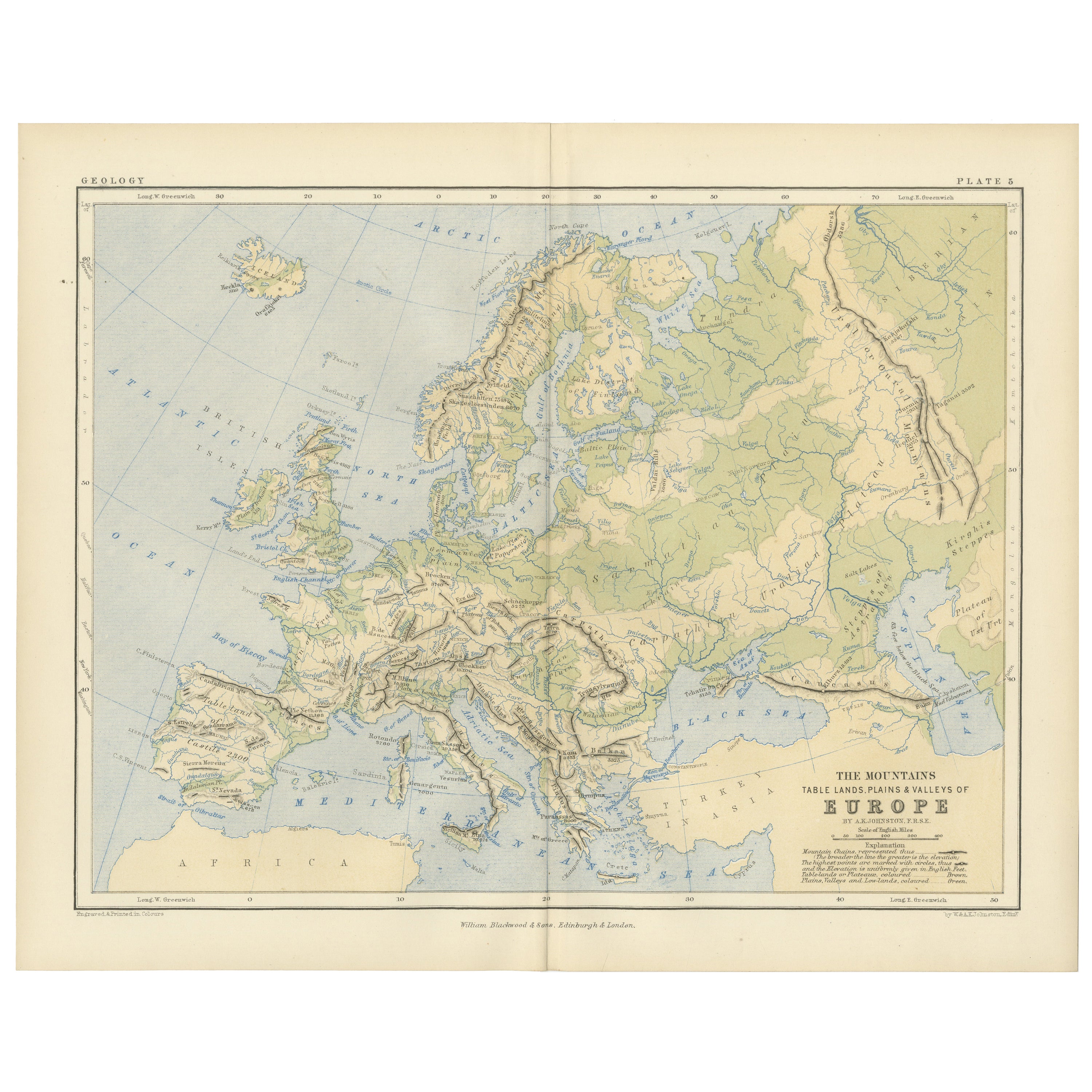
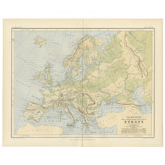
Mostra tuttoGeological Map of Europe by A.K. Johnston – Mountains and Valleys 1852
Geological Map of Europe by A.K. Johnston – Mountains and Valleys 1852
This elegant 1852 map titled "The Mountains, Table Lands, Plains & Valleys of Europe" was designed by the accl...
Categoria
Di antiquariato/d’epoca, Metà XIX secolo, Scozzese, Stampe
Materiali
Carta
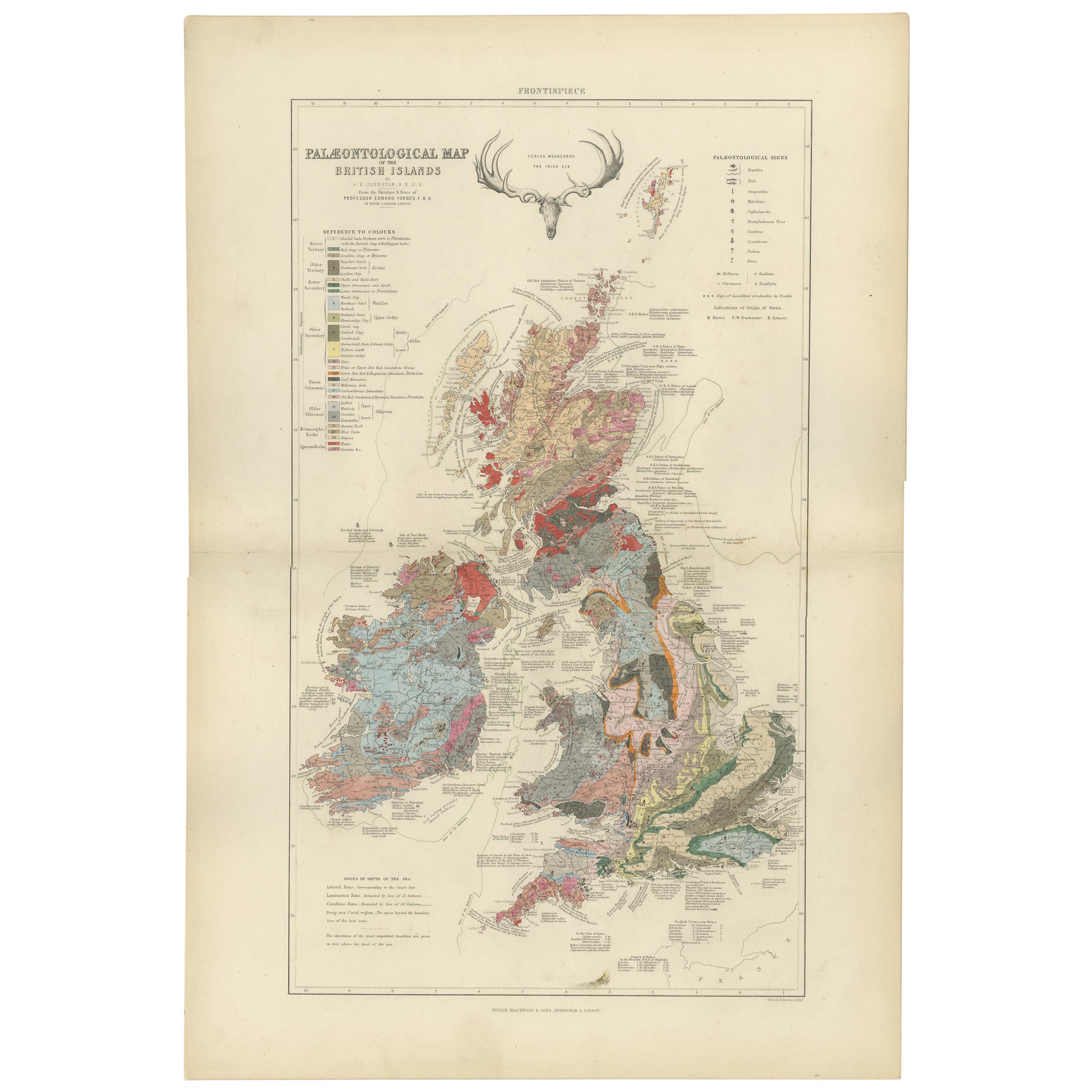
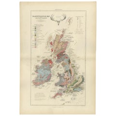
Mappa antica della paleontologia delle isole britanniche di Johnston del 1850
Mappa antica intitolata "Mappa paleontologica delle isole britanniche". Mappa originale d'epoca che mostra la paleontologia delle isole britanniche. Questa mappa proviene da 'The Phy...
Categoria
Di antiquariato/d’epoca, Metà XIX secolo, Mappe
Materiali
Carta
360 € Prezzo promozionale
20% in meno
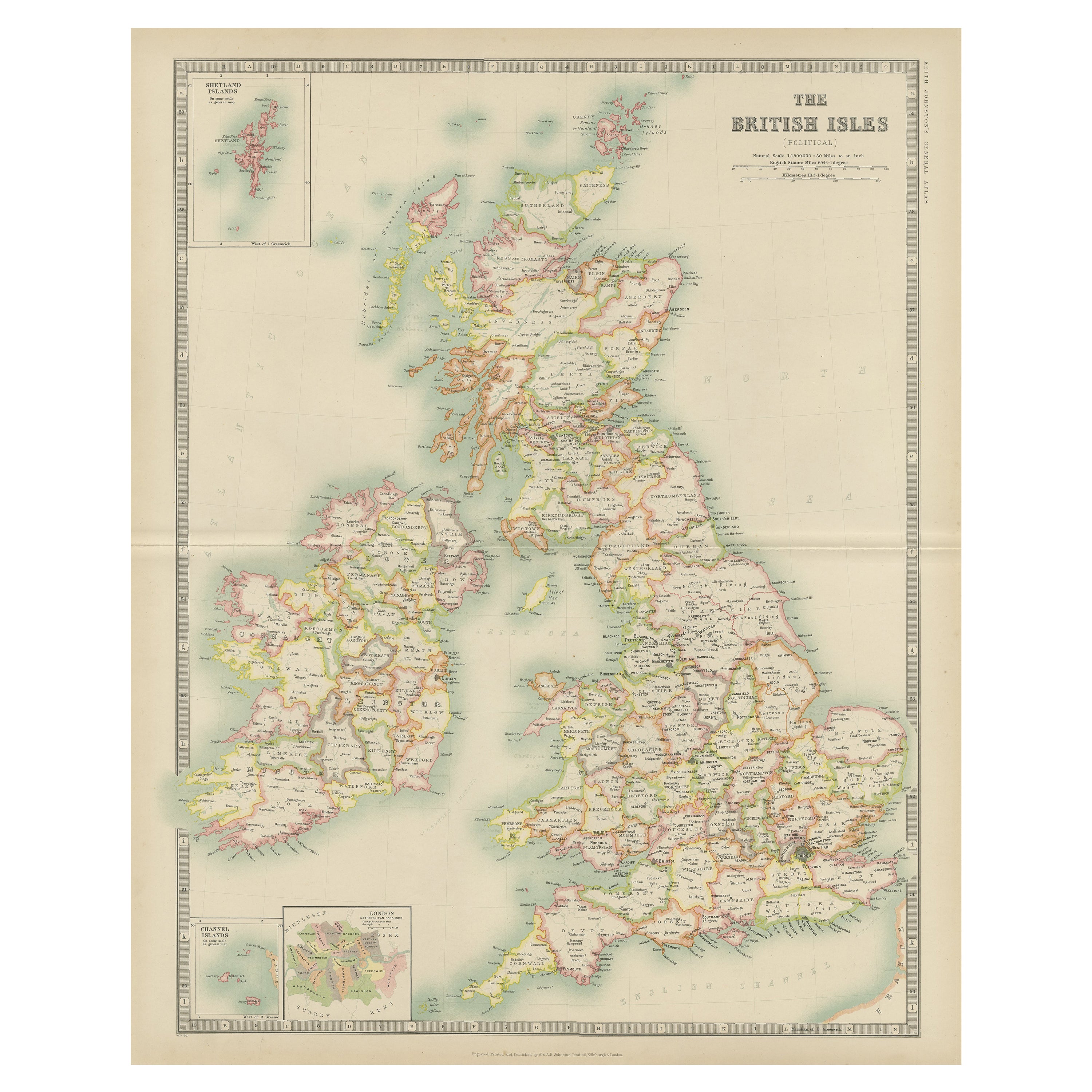
Mappa antica delle Isole Britanniche di Johnston del 1909
Mappa antica intitolata "Le isole britanniche". Mappa antica originale delle isole britanniche. Con mappe aggiuntive delle Isole Shetland, delle Isole Chanel e di Londra. Questa mapp...
Categoria
Inizio XX secolo, Mappe
Materiali
Carta
200 € Prezzo promozionale
20% in meno
Mappa antica delle Isole Britanniche di Balbi del 1847
Carta geografica antica intitolata "Iles Britanniques". Mappa antica originale delle isole britanniche. Questa mappa proviene da "Abrégé de Géographie (..)" di Adrien Balbi. Pubblica...
Categoria
Di antiquariato/d’epoca, Metà XIX secolo, Mappe
Materiali
Carta

120 € Prezzo promozionale
20% in meno
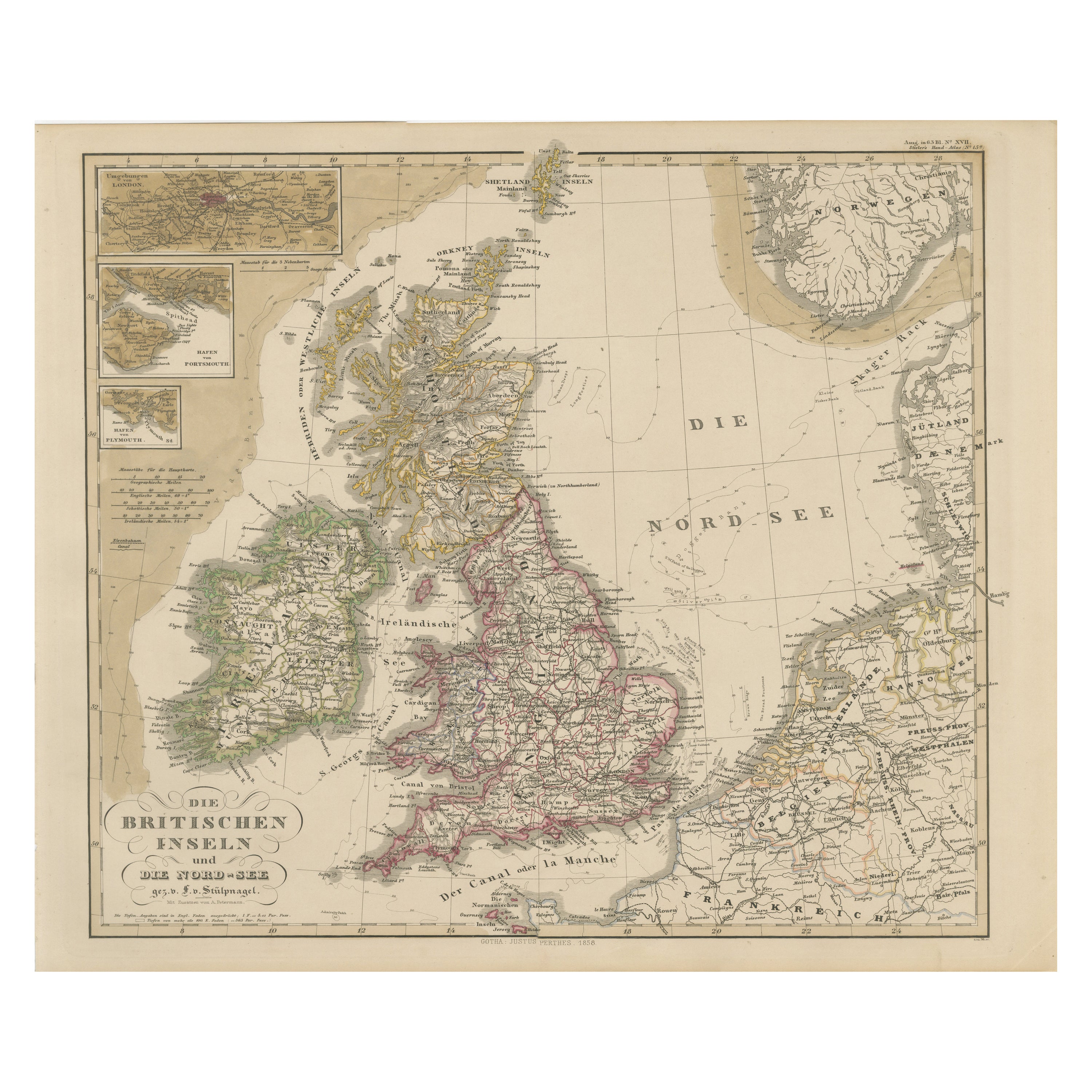
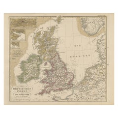
Carta geografica antica della Gran Bretagna e dell
Irlanda con dettaglio del Mare del Nord - 1856 Stülpnagel
Mappa antica delle Isole Britanniche e del Mare del Nord di Stülpnagel, 1856
Questa mappa del 1856, splendidamente dettagliata, intitolata *"Die Britischen Inseln und die Nord-See "...
Categoria
Di antiquariato/d’epoca, Metà XIX secolo, Tedesco, Mappe
Materiali
Carta
Carta geografica antica dell
Inghilterra e del Galles "Nord" di A.K. Johnston, 1865
Carta geografica antica intitolata "England and Wales (Northern Sheet)". Questa mappa proviene dal "Royal Atlas of Modern Geography" di Alexander Keith Johnston. Pubblicato da Willia...
Categoria
Di antiquariato/d’epoca, Metà XIX secolo, Scozzese, Mappe
Materiali
Carta

Ti potrebbe interessare anche
Mappa antica originale della Scozia di Dower, 1835 circa
Bella mappa della Scozia
Disegnato e inciso da J.Dower
Pubblicato da Orr & Smith. C.1835
Senza cornice.
Spedizione gratuita
Categoria
Di antiquariato/d’epoca, Anni 1830, Inglese, Mappe
Materiali
Carta

Inghilterra e Galles, Nord. Atlante del secolo antica mappa d
epoca
L'Atlante del Secolo. Inghilterra e Galles, Part One".
Mappa antica originale, 1903.
Piega centrale come da edizione. Nome e numero della mappa stampati sugli angoli del retro.
Fog...
Categoria
Inizio XX secolo, Vittoriano, Altre stampe
Materiali
Litografia

Grande mappa originale d
epoca del Regno Unito, 1920 circa
Grande mappa del Regno Unito
Non incorniciato
Colore originale
Da John Bartholomew and Co. Istituto Geografico di Edimburgo
Pubblicato, circa 1920
Spedizione gratuita....
Categoria
Vintage, Anni 1920, Britannico, Mappe
Materiali
Carta

Inghilterra, Scozia e Irlanda: Una mappa della Gran Bretagna colorata a mano di Tirion
Di Isaak Tirion
Si tratta di una mappa in rame a doppia pagina colorata a mano della Gran Bretagna intitolata "Nieuwe Kaart van de Eilanden van Groot Brittannien Behelzende de Koningryken Engeland, ...
Categoria
Di antiquariato/d’epoca, Metà XVIII secolo, Olandese, Mappe
Materiali
Carta

609 € Prezzo promozionale
20% in meno
Vecchia mappa orizzontale dell
Inghilterra
Di Tasso
ST/520 - Antica e rara carta italiana dell'Inghilterra, datata 1826-1827 - di Girolamo Tasso, editore a Venezia, per l'atlante di M.r Le-Sage.
Categoria
Di antiquariato/d’epoca, Inizio XIX secolo, Italiano, Altro, Stampe
Materiali
Carta

L
Inghilterra e le isole britanniche: Una grande mappa del XVII secolo colorata a mano da de Wit
Di Frederick de Wit
Questa è una grande mappa del XVII secolo dell'Inghilterra e delle isole britanniche colorata a mano da Frederick de Wit, intitolata "Accuratissima Angliæ Regni et Walliæ Principatus...
Categoria
Fine XVII secolo, Altro stile artistico, Stampe (paesaggio)
Materiali
Incisione
